
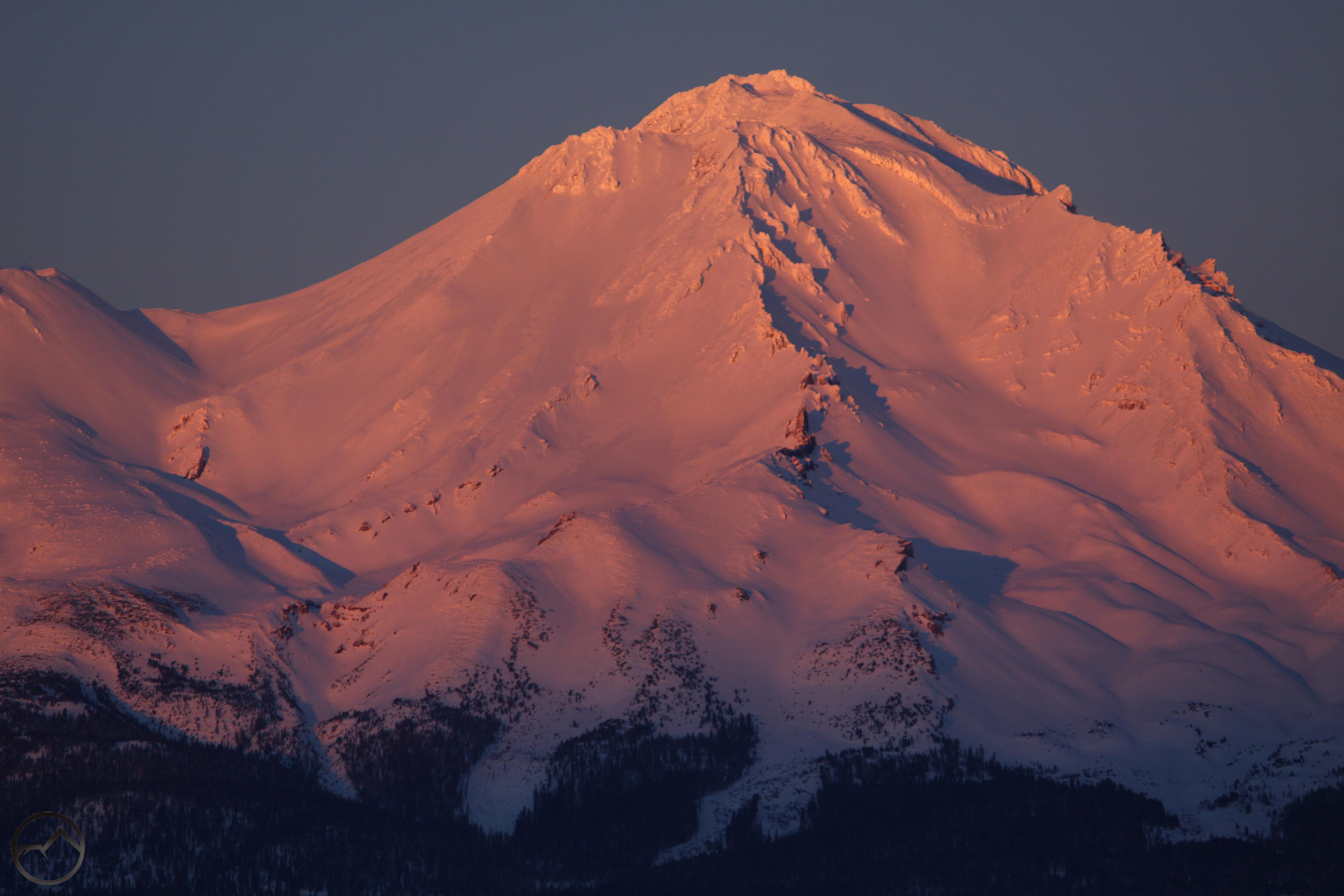
 At a lofty 14,179 feet, Mount Shasta is one of the tallest mountains in the American West. It is a grand volcano, soaring over 5,000 feet above the tallest neighbor, and presides majestically over northern California. Flanked by the Klamath Mountains on the west and the Cascade Crest to the east, the Mount Shasta region offers numerous exceptional hiking opportunities, both on the great mountain and in the ranges that surround it. Whether one is looking for wild hikes with crashing waterfalls and massive glaciers or the quiet solitude of alpine lakes and meadows, the Mount Shasta region offers spectacular hikes that will challenge and satisfy hikers of all skill levels.
Hikemtshasta.com strives to be the most exhaustive, complete resource for hiking trails in the Mount Shasta area. I hope that you will find it useful for planning a trip to the area or that it will lure you to explore the area further! Please feel free to leave comments on the appropriate trail pages if you have hiked the trail and enjoyed it or if conditions have changed and the page needs to be updated!
The purpose of Hike Mt. Shasta is to provide quality information about the trails and landscape of the Mount Shasta region. It is my hope that this site will enable anyone to explore and enjoy the majestic vistas and spectacular geography found throughout the area. If I can offer any more advice on questions large and small or you have a suggestion about how the site can be improved, please email me at:
bubba.suess(at)hikemtshasta(dot)com
Please visit hikemtshasta’s Facebook page to receive updates on new trails added and other material being added to the site.
**I am still very happy to answer questions of any reasonable type. However, due to the volume of queries I get, hiking questions will be prioritized over those concerning camping. I may not be able to address all inquiries regarding where to camp or things of that nature. Hopefully this will not significantly inconvenience anyone.

Thanks for visiting my blog (livingwithmyancestors.wordpress.com) and liking! What a beautiful region Mt. Shasta is and you have a great site for those able and willing to hike it! 🙂
Hello! I’ve loved reading your site. I have one day (driving down from Medford, OR on Thursday) and would love to do a hike that let’s me experience the mountain best in 3-6 mile range. I’ve done the paradise loop trail at rainier and if you’re familiar with it, it’s one of my favorites. I’m 31 and 160 lbs if this helps. I love hiking to views.
Wow, what a great local hiking website! Congrats and best wishes on your soon to be released hiking guide for the Mt. Shasta region. And thanks for dropping by my site too (http://tucsonhikes.wordpress.com/). Take care and enjoy the beauty of your region of the country, as I do the Southwest.
I appreciate your kind words. I would love to publish all this stuff, but who knows. I am a huge fan of the southwest and I am always glad to find good sites on that part of the country so I can travel vicariously. I love Cafe Poca Cosa too, for what it is worth. Best Mexican food I have ever eaten.
Hi Bubba, I wish to be able to use a copy of your photo, “Looking West from the Center of Charon’s Garden Wilderness, Wichita Mountains, Ok in a autobiography I want to publish about a college trip I took their in a geology field trip. How do I get permission and will gladly pay a fee and of course give credit as author. Thanks, Graham
What a great site you have put together. I hike all over the North State and now have a new place to find hikes. Your photos are beautiful too. One question – are the total miles round trip or each way? Thank you for all your hard work!
Thank you very much for the comment. It is sincerely appreciated! Regarding the mileage, it is all given round trip. I hope the site helps you find some awesome place you haven’t been to before!
thanks for giving it all away!!!
What exactly are you concerned about being given away?
Typical siskiyou county native who resents or doesn’t want any or many people in Their outdoors.
Though I frequently feel same way when I grew up about Sierra’s. Also was hiking n backpacking at early age only was early 60’s. People would jump out at this girl leading midget mule when we come out from week trip. Was very few people that now are popular. Wagon creek had few no trespassing signs. One clearly meant it.
What a wonderful asset you have built here! I do weekly day hikes around the DC/MD/VA area and in the Shenandoah Mountains, and thanks for visiting my blog to read about one of them. They are nowhere near as serious an undertaking as hiking around Mount Shasta would be! If I ever travel to the Mount Shasta area to do some hiking, this is definitely THE go-to site to prepare for the expedition! Thanks again & all the best!
Best website I’ve found, by far, for Northern Ca hiking trails. I’m so glad it came up in my search results. My husband and I are always looking for local hikes. Thank you for this great resource!
Please add a link on your Gravatar page that leads readers to your blog. I had to Google you, and then I found you in a WP support forum. And, here I am. Thanks for visiting my blog!
Thanks for the effort to find my site, it is much appreciated! I thought that I had a link on the gravatar. I went back and added it again, so I think it should work now.
From my phone, I was linked straight to your blog from your Gravatar icon in my notifications. Last night, I was on my laptop.
When the distance says “total distance” do you mean one way, or round trip?
The whole thing, whether it is a loop or out and back. Total at the end of the hike.
Thank you for this amazing resource. We will follow your site and definitely use it when hiking the area. Will add Mt. Shasta to our itinerary when we return from AK this year!
Thanks for stopping by my site and leaving your message. I was also banned from the forums. As Winston Churchill once said, “You have enemies? Good, that means you stood up for something in your life.” Bottom line is, i don’t need any social, political or religious issue shoved in front of my face like that. WordPress has lost my respect.
Did they tell you why you were banned? I got no explanation other the “you violated community standards”. I have asked for elaboration and gotten none. I was not even making an issue about the rainbow banner. I was largely complaining about their response. Watch out for totalitarians!
I am assuming it was because i posted to often about the same subject. Funny that they don’t like “spam”, but they are okay with putting up the rainbow banner on everyone’s site. Is that not “spam”? Bunch of hypocrites if you ask me.
Man, I only posted two or three times. They are seriously behaving like fascists. This is a scary new age we are moving into. I hope sanity will prevail and end this type of cultural authoritarianism.
You are right. I find it unnerving that the young generation these days seems to jump on any “social bandwagon” out there and don’t think hard about what they are actually supporting. If it’s on social media and the flavor of the day, let’s jump on it. If you run contrary to what they believe, you are labelled with such words as bigot. It seems like going against the mainstream and traditions is the norm these days. I simply don’t want my site politicized in any way.
I am not excited about where this leads. Watch your back, and I guess watch what you say.
Hey, thanks for finding me & liking my post about Great Basin Nat’l Park. We have passed through Shasta many times. One of my favorite plant nurseries is at the entrance to the city park with Sacramento River headwaters coming from the rock. Now I know where to look for day hikes, am looking forward to going there again.
Spring Hill nursery!
Great site! However, the directions to Gateway Trail are wrong; they took us to the Black Butte trailhead. But Google Maps set us on the right path.
Are all of these trails open in the winter time? I am looking to hike the Brewer Creek and Ash Creek Falls trails this weekend and just wanted to make sure all of the roads to them and the trails themselves are accessible. Thank you!
Definitely not open. There may be only a little snow out there, but those trailheads are not accessible this time of the year.
Do you know if Sheep Rock near A12/Highway 97 has a trail?
It does not, but the route is pretty easy to follow. Most of it is on BLM land.
Would you have any information on the route to the elusive Coquille Falls on the northface of Mt Shasta?
There are a couple of ways to get there. Both involve rough roads. The most direct way but more remote and with worse roads is to come from the south. The other option is longer but the roads a bit more reliable, which is to hike in from the North Gate trailhead. Pass the North Gate plugs and continue toward Bolam Creek. It is pretty straightforward. It is a beautiful spot!
Can you create a category of trails by difficulty? Can you suggest any easy trails? We have done the Sacramento River trail near Dunsmuir and the Lake Siskiyou trail. Any other easy ones?
Love this site! We haven’t made it to Shasta yet, but when we get the chance to go, we will definitely reference this.
Thank you! When you come up, let me know if I can help plan or anything like that.
Hi, your photos are spectacular. Is there any possibility to use on a new website I’m working on?
Do you have a license fee? Thanks for letting me know and huge thanks for your site.
Got my PCT start date and launched my blog! Probably going to revamp it over the winter, as I don’t really like the layout, but it’s official! March 23!
http://www.mexicotocanada2020.com
See you in Mt Shasta!
Ian
That’s awesome. If it is an average-to-light winter, that is a perfect start date. Keep me posted and let us know how we can help.
I would like to know more about grizzly falls/ grizzly creek trails. When is good time to go hike at that 14 miles trail? Please call me at 2096173571 and my name is Texan Thungc
Wonderful butterfly wings on your daughter, butterflies represents new life, II Cor. 5:17
How do you get to the hole in the ground geological area?
What a wonderful site! Thank you for sharing your passion. I want to share how I found your site. I was using looking at Google maps in terrain mode, and noticed an area east of Mount Shasta that looked interesting. It was Ash Creek Butte. I clicked on ‘Ash Creek Butte’ to see what it would return, and your page ‘Ash Creek Butte Scramble’ was listed. Now I have so much to explore on your site. I followed you on FB and Feedly as well. Thank you so much!
Hi Ray. I really appreciate you checking the site out. I hope you find it useful in the future and that you are able to make it here to Mount Shasta some time!
Hello, I’ve spent several years exploring the Shasta area with this website and your books as guides. I don’t know whether or not i have met you in the real world on a hike or while working as Horse Camp caretaker. Anyway I am planning on a backpack in South Warner wilderness and am going in from soup springs trailhead on slide creek trail to summit trail and then north to Patterson lake. Hope to make a side trip to climb eagle peak. All the routes I’m seeing come from the east. Do you have any information about climbing eagle peak from the west off of Summit trail? Thanks, Steve Eddy
Nice talking to you Bubba, I was checking out your web site Awesome, I see several trails to try that my fur babies can go running with me!!!
Thanks
Mark Mazzoni
Hi, we are visiting Shasta this week and love your description of the heart lake trail. https://hikemtshasta.com/trinity-divide-trails/heart-lake-trail/. However, the US Forestry website https://www.fs.usda.gov/recarea/stnf/recarea/?recid=6571 seems to says that the trail of the East of the lake (4W02) trespasses on private land. Do you know what the situation is? THANKS! Alan
Hi Alan. The USFS is both correct and incorrect. Here is the situation. The land in question was private property, which is what prompted the note on the USFS site. However, it has been purchased by a non-profit and is in process of being transferred to the USFS. While in the non-profit’s possession, significant trail work has been done and nearly 40% of the Heart Lake trail has been reconstructed or rerouted. This was done in anticipation of the transfer to public land. While owned by the non-profit, the land is open for hiking, with no issues whatsoever. I imagine the USFS website will only be updated once the transfer of ownership is completed.
Hi Bubba – greatly appreciated. Thank you. We hiked the route with no problem.
I am glad to hear it!
I am a writer for Mountain Valley Living Magazine, located in the town of Westwood, CA. I would like to use the photo from your website titled: Collapsed ceiling inside Pluto Cave, with attribution.
Hello Hikemtshasta.com!
I am the owner of CampSiskiyou.com and am very appreciative of all the info yoi have on your website on all of the hiking trails for the area. I also have a trails map but I do not offer any details like you do and I have a reference to your website with link for users to get more information. If it is not too much trouble, I would greatly appreciatr a link to CampSiskiyou.com on your site so that users have a resource for other information about the area. Thanks so much for what you do.
Hello. I’m hoping you can give me some advice as to the best month(s) to do this particular 3 day hike. This will be our groups first time backpacking and we are worried about summer heat, rain and mosquitoes specifically. Our itinerary would be as follows:
Gumboot Saddle trailhead, camp at Porcupine Lake, on to Deadfall Lake with a summit of Mount Eddy.
Thank you in advance for any insight you might have for us!
The photos are breath-taking! I am an artist from Germany – maybe I can paint one of this wonderful Mount Shasta landscapes. Of course only with your permission! – please contat me: s_linke@gmx.de
You can see my paintings on Instagram: sarah_linke_germany
May website unfortunately is not finished yet.
Thanks a lot in advance.
Hi Bubba…I’ve been hiking into Thousand Lakes Wilderness since the 70s, but not in awhile. Just checking if the fire of a few years ago has made it untenable for hiking and camping?
Hi Dave. I have good news for you! The only fire to burn in the 1k Lakes was the Eiler Fire in 2014. Amazingly, it started right on the banks of Eiler Lake and then burned east, leaving the significant majority of the wilderness unburned and pristine. Only the south and eastern shores of Eiler Lake burned, along with Eiler Butte (good view of the crater from the top) and the north side of Freaner Peak really burned. Of course, the fire was large and moved east, burning the route from Hat Creek to the trailheads (especially Cypress) and onward into the valley and Burney Mountain.
You can see the outline of the fires and the wilderness on this map:

All in all, I would say things are in pretty great shape. I was there a couple of years ago and the trails were in good condition. It’s a great spot. Have a good time!
Hi:-) this August 19, 2024 the sun will be setting and the Full moon rising very close together and my husband and I wanted to plan a hike. The same thing was happening in 2020 and we hiked the Lassen Peak Trail. This time we would like to do that in the Mount Shasta area. My husband and I were wondering if heart lake would be a good vantage point. Also, I am not in as good of shape so a shorter hike is also appealing. What do you think? Can we see the moon rise very well from Heart Lake?
Heart Lake is a great place for sunsets but only in so far as you can watch the alpenglow on Mount Shasta. The moon and sun will be behind the cliff and not particularly visible from the lake. Note that from the summit of Lassen you have nothing obscuring your view in any direction, so solar and lunar position was good no matter what. I would hop on mooncalc and suncalc to help you pick a good spot.