
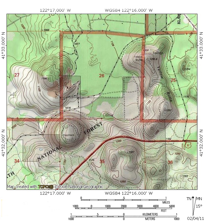
At A Glance
A short, easy hike up a low lava dome boasting excellent views of the Shasta Valley, Klamath Mountains, Cascade Crest and Mount Shasta. This is an excellent winter hike.
Total Length: 2.6 miles
Elevation Gain: 240 feet
Season: All year
The Needle On The Haystack

Sunset from the Haystack.
The Haystack is an all but forgotten volcanic dome in Northern California’s Shasta Valley. Lying in the shadow of mighty Mount Shasta, the valley is an area often overlooked when it comes to outdoor recreation. While the valley has numerous interesting small mountains, most people simply pass on through, intent on getting to the high country to the south. Those looking with interest at the valley’s small mountains are forgiven for assuming they are on private land due to the abundance of cattle ranches visible from the highways. While this is true in most of the Shasta Valley, there are a couple of significant exceptions to the rule. The Haystack, found on the north side of Highway 97, is one of the best of these exceptions. Separated from the rest of the Shasta Valley’s small peaks, the Haystack, along with neighboring Yellow Butte, offer great off-season hiking options with astounding views in all directions. When the high country above the Shasta Valley is still cloaked in snow, a trip to the top of the Haystack will quench the thirst for alpine scenery.
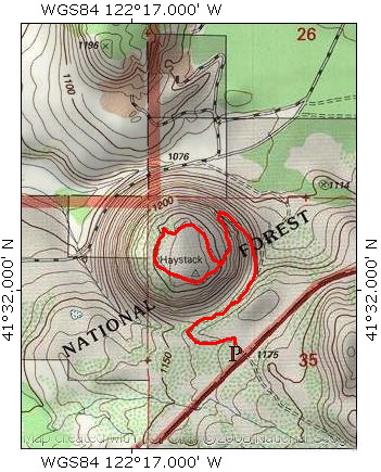
The Trail

Trailhead view of the Haystack.
The Haystack Trail begins at the parking pullout along Highway 97. Initially, the dusty path leads west, through sage and juniper and an occasional ponderosa pine. At one time, there used to be several boxes containing beehives. These have not contained active hives for some time and should not cause concern of numerous bees flying around. However, they undoubtedly have been taken over by wasps and should not be disturbed. After a short distance, the trails turns to the right and enters into a shallow cully formed by the northern slope of the Haystack and the higher ground near the parking area. Gnarled tufa formations protrude from the rocky flank of the Haystack. Tufa is a soft volcanic rock made of compressed ash. This same rock is prevalent in Bandelier National Monument in New Mexico, where the ancient Native Americans built dwellings in the caves formed in the tufa. Some small caves can be found on the sides of the Haystack, though none were ever occupied.

Herd Peak and Sheep Rock from the Haystack Trail.
After 0.3 miles, the trail finally emerges from shallow canyon and turns to the north, staying to the left a fork in the path. The route to the right drops down into the valley below. This is the most interesting section of the trail in terms of routing. Beyond the canyon, the ground falls away steeply, revealing that the Haystack is much taller than it appears from Highway 97. Near the parking area, the Haystack is connected to higher ground near the lava flows coming off of Mount Shasta. On the dome’s three other sides, the higher ground gives way and drops precipitously down into Juniper Valley, a section of the Shasta Valley. As the trail proceeds north, it traverses the flank of the Haystack, slung about 300 feet above the Shasta Valley. Another 0.3 miles further, the trail switchbacks, now turning to the south. The route continues to climb 0.2 miles up the flank of the Haystack.

Haystack view of lenticular clouds forming on Mount Shasta.
Unlike its neighbor Yellow Butte, the Haystack does not have a pointed summit. Instead, the dome has a broad summit plateau covered in sage, dry grasses and junipers. This allows for more hiking, as there is a 0.65 mile loop that circles the perimeter of the plateau. There is no single spot that has the best views, as each directions takes in its own distinct viewshed. The most memorable comes at the beginning of the loop. There is a fantastic view of Mount Shasta from the eastern edge of the plateau. On the west side, there are views of the Trinity Divide, Scott Mountains and Marble Mountains. To the north, the Haystack yields visions of southern Oregon, including such notable peaks as Mount Ashland and Pilot Rock. To the east, the Cascade Crest dominates, especially Herd Peak and the incredibly rugged Sheep Rock.
Directions

Zoom view of Mount Shasta from the Haystack.
From downtown Weed, drive east on Highway 97 for 10.5 miles. A small dirt road blocked by a green gate will be on the left. Park next to the gate. 9.5 miles from Weed, Highway 97 crosses over usually dry Whitney Creek. Visible ahead is the Haystack with Yellow Butte beyond. The dirt road is 0.5 miles beyond Whitney Creek. Be sure to close the gate at the beginning and end of the hike to the Haystack.

Pingback: Off Season Trails: Winter Hiking In The Shasta Valley | Hike Mt. Shasta
We live in Silicon Valley, we get to this area every few years, and we consider ourselves older, cautious hikers. Based on nothing more than the clarity of this description, we decided we’d do this hike after breakfast in Weed and before driving to a dinner date in Eugene.
We are so glad we did. We were a bit nervous about finding such an obscure trailhead off of such a major highway, but the directions were very good (contribution — “about a 40′ side road leading to a faded light-green gate easily visible from the road”). The count off from the bridge over the dry creek put us right on the site, and we got it on the first pass.
The “caution-bees” sign on the gate was further confirmation that we were in the right place, though the bee boxes are long gone and scrub is reclaiming their former area.
The trail, itself, was originally jeep track — though there have been some plant growth and fallen rock, since. It’s clear, safe, and stable. The description was spot-on and enhanced our experience.
The only regret is that we spent so much time photographing stuff along the way that we had to cut the circumnavigation trail short and still ended up half-an-hour late in Eugene. There are lovely details on the way up, magnificent vistas over Juniper Valley, great shots of Shasta, and glorious views from the top.
Well worth the effort, and well-documented here.