
At A Glance
A fairly short but very scenic trail in the Trinity Alps with an extremely steep section that accesses the beautiful South Fork Lakes.
Total Distance: 5 miles
Elevation Gain: 900 feet
Season: Summer, Fall
The Serene South Forks

Upper South Fork Lake.
The northeastern corner of the Trinity Alps is a large knot of watershed divides that separates the waters of the Salmon, Scott and Trinity Rivers. Several lakes lie in beautiful basins along these divides, making great destinations for fairly easy day hikes. Among the best of these lakes are the small South Fork Lakes, which constitute the headwaters of the South Fork of the Scott River. The trail is fairly short but is surprisingly diverse. The lakes themselves are gorgeous, lying in a deep glacial cirque with tall cliffs soaring high overhead. Unfortunately there is a price to pay to get to this gorgeous spot; the trail to the lakes has an extremely steep section that, while not lasting a long time, is as brutal a pitch as found anywhere in the Trinity Alps. Still, the beautiful lakes and great views are worth the effort, whatever the price. In addition to these obvious benefits is the unusual geography of this area. The focal point of the divides between the Salmon, Scott and Trinity watersheds is unnamed peak 7,794. This is a rare example of a triple-divide peak, where the waters flowing off of the peak are separated between three different watersheds. Though this unusual fact is completely unheralded, the rugged peak can still be appreciated via the South Fork Lakes Trail, adding a lot of interest to an already scenic trail.
The Trail

Crossing the South Fork of the Scott River.
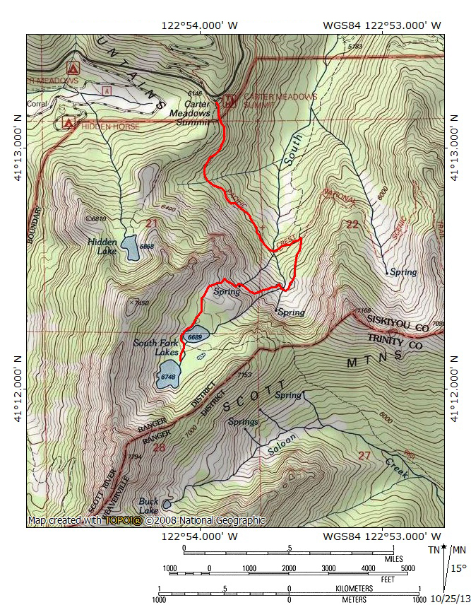
The South Fork Lakes Trail begins at the PCT trailhead at Carter Meadows Summit. This trailhead is without doubt the easiest Trinity Alps trailhead to reach. Only about 30 yards of paved driveway separate the parking area from the Cecilville-Callahan Road. Interestingly, there is also a pave helipad at the compact trailhead as well. The path immediately descends steeply to a four-way junction only a few yards from the beginning of the trail. To the far right the PCT continues north toward the Russian Wilderness, which lies just north of Carter Meadow Summit. Moving to the left, the next trail leads down to Carter Meadows and the Hidden Horse Campground. Continuing left, the next trail is the short and stupendous Hidden Lake Trail, the easiest trail in all of the Trinity Alps, though it does not lack great scenery despite its short duration. Finally, the last trail at the junction is the PCT, heading to the south. Take this trail and begin to descend gradually. The trail crosses the boundary into the Trinity Alps immediately. Though the road is only a short distance away, its influence, including the sound of occasional cars is quickly forgotten. As the trail heads south the views of the South Fork of the Scott River’s headwaters basin improve. Most notable is a tall, craggy peak looming over a deep basin. The trail passes through beautiful forests along this section of trail, punctuated at times by small boulder fields and rocky benches. The views come and go as the trail begins to arc to the west. A small stream is crossed at 0.45 miles. Another 0.4 miles further leads to a series of crossings, the largest of which is the Scott River’s South Fork, newly emerged from its headwaters. The PCT continues another 0.15 miles beyond the crossing to the junction with the South Fork Lakes Trail. The trail actually starts over a mile away down in the basin but taking the PCT is more scenic and makes climbing the 700 feet up to the junction unnecessary.

Yup, the trail climbs to the top of that cliff.
At the PCT’s junction with the South Fork Lakes Trail, turn right, onto the South Fork trail. It begins to climb moderately through dense forest, along the rim of a gully. Soon the path levels off and emerges in a deep basin. The cliffs around the basin are over 1,000 feet high. A small but scenic meadow fills the bottom of the basin. The trail heads south through the lush grass. At first it seems as though the trail is going to climb the extremely steep band of trees at the south end of the basin but it makes a sharp turn to the west, angling toward the steep cliffs on the west side of the basin. Look closely at the cliffs and notice the deep rift through which falls the South Fork in a nearly vertical cataract. The trail crosses the South Fork shortly after it completes its 800 foot tumble down the cliff. Immediately after it crosses the creek (which may be dry late in the season, though springs keep the flow steady by the time it reaches the PCT crossing) the trail begins its extremely steep climb up to the lakes. Fortunately, the trail makes use of switchbacks, moderating the steepness somewhat. Halfway up the climb there is a nice level pitch that cuts across an area with numerous springs flowing across the trail. Be sure to keep looking to the north for good views of the southern end of Scott Valley. Beyond the spring area, the trail resumes its relentless climb.

Lower South Fork Lake.
Finally the trail levels off as it enters the South Fork Lake’s cirque. Crags rise just to the north of the trail. The path maintains a level course through open country for 0.2 miles to the edge of Lower South Fork Lake. From the trail, the lake looks a bit nondescript, deep but with tree-lined shores. Head off the trail to the left, rounding the lake to the east. After passing a couple of small campsites, one arrives at the lake’s outlet. Here one gets a better appreciation of its beauty. The sheer headwall of the cirque can be seen rising high above the lake to the south. However, as attractive as it is from this perspective, it is overshadowed by the awesome upper lake. To reach it, return to the trail and continue south. The path rounds the south shore of the lower lake and then passes through a deep, dark old growth forest. Soon the route deposits hikers at the outlet of Upper South Fork Lake. The grand cliffs rise directly out of the lake’s cold waters and soar over 1,000 feet up to the summit of 7,794, the triple divide peak. It is a gorgeous spot, worth the steep climb.
Directions

Peaceful morning at Lower South Fork Lake.
From Mount Shasta City, drive north on Interstate 5 for 12 miles. Take the Edgewood/Gazelle exit, turn left under the freeway then immediately turn right onto Old Highway 99. Proceed north for 7 miles, entering the small community of Gazelle. Turn left onto the Gazelle-Callahan Road. Drive this scenic road for 24.8 miles, continuing another 2.1 miles after it merges with Highway 3. At the north end of the small village of Callahan, turn left onto the Callahan-Cecilville Road, which is also named Forest Highway 93. Continue for 11.8 miles on this interesting road to the signed turnout for the Carter Meadow Summit Trailhead.

beautiful place went to brimerton in the 80’s was just a picture perfect place would love to a go back one day!
Pingback: The Trinity Alps’ Carter Meadows Area: An Abundance Of Riches | Hike Mt. Shasta
Pingback: Looking For Relief From Smoke? Trinity Alps Might Offer A Chance | Hike Mt. Shasta
Pingback: South Fork Lakes (Trinity Alps Wilderness, CA) | Live and Let Hike
Lower lake is a basin lake. Upper lake is a cirque lake. The place is a park in the sky. The trail in is the steepest ever but on top the topography is almost level. I know of no other place in the Alps with such a meandering topograpy so high up on the mountain. It is epic.