
At A Glance
An easy hike to large, scenic and meadow ringed East Boulder Lake. A long extension links the trail to the Pacific Crest Trail with incredible views and then loops past Middle Boulder Lake and returns to East Boulder Lake.
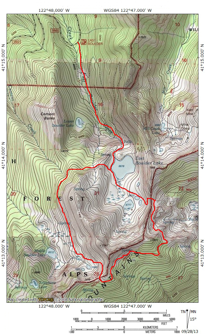
Total Length: 4 miles (to East Boulder Lake), 10 miles (complete loop)
Elevation Gain: 800 feet (to East Boulder Lake), 1,600 feet (complete loop)
Season: Summer, Fall
Big, Bold Boulder Lake

East Boulder Lake.
The East Boulder Lake Loop provides easy access into the interior of the Scott Mountains portion of the Trinity Alps Wilderness. East Boulder Lake is the largest body of water in the Scotts, a range that extends east beyond the Trinity Alps Wilderness before merging with the Trinity Divide. The Scott Mountains form the divide between the Trinity and Scott Rivers. Even though less than a mile separates the waters flowing off of either side of these mountains, it is over 50 air miles before they meet again when the Trinity River flows into the Klamath River. The waters coursing through these two rivers must travel hundreds of winding river miles before this dramatic reunion. The loop trail is routed on both sides of the divide, crossing back in forth between the Scott and Trinity River watersheds. The interesting geography, compounded by the unusual geology that is a highlight of the Scott Mountains and the opportunity to explore numerous lakes makes the East Boulder Lake Loop a fantastic hike and an excellent introduction to the Scott Mountains portion of the Trinity Alps Wilderness.

Big Marshy Lake and the Bear Lake area from the PCT.
The Scott Mountains form the northern most subrange within the Trinity Alps Wilderness and are a quintessential part of the Red Trinities; an area typically constituted by red peridotite or serpentine rock, rather than the granite the typifies the area known as the White Trinities. The Scott Mountains are distinct among other subranges in the Trinity Alps for a few noteworthy reasons. First, they are the only part of the Trinity Alps traversed by the Pacific Crest Trail. The PCT departs the actual Pacific Crest south of Mt. Shasta and follows the crest of the Trinity Divide (a separate mountain range that forms the divide between the Trinity and Sacramento Rivers, which is not to be confused with the Trinity Alps) to Mt. Eddy. North of Eddy the PCT traverses the flanks of China Mountain, the hinge upon which the Trinity Divide merges into the Scott Mountains. The Scotts are bisected by Highway 3. After crossing Highway 3 the PCT enters the Trinity Alps Wilderness. Only 18.9 miles of the 2,400 miles pass through the Trinity Alps along the Scott Mountain Crest. From there it continues north through the Russian, Marble Mountain and Red Butte Wildernesses before crossing into Oregon and rejoining the Cascade Mountains and the true Pacific Crest. Another unique attribute of the Scott Mountains is the presence of sagebrush, particularly on the north side of the range. While numerous explanations for why this plant appears here have been attempted, it remains a mystery. Nonetheless, it is surprising when one emerges from the cool forests below East Boulder Lake and finds this arid plant growing alongside extensive, lush, lakeside meadows. The presence of numerous, large lakes is another excellent (although they certainly does not have a monopoly on this commodity) attribute of the Scott Mountains.

Sage Brush, Garter Snake and Middle Boulder Lakes.
The Scott Mountains portion of the Trinity Alps Wilderness is the best part of the range for day hiking. There are six trails relatively easy trails leading into lake basins on the north side of the Scotts and all of these are great day hikes. This stands in stark contrast to the rest of the Trinity Alps, where most areas require at least one night spent in the wilderness in order to access destinations. Only the northeast corner, along Highway 3, presents a similar opportunity for numerous day hikes. However, unlike the Highway 3 area, the trails in the Scott Mountains portion of the Trinities are connected by the PCT. Consequently these trails can either be done independently or can be linked via the PCT to form longer trips. Of all these trails in the Scott Mountains part of the wilderness, the trail to East Boulder Lake is the best. The main lake is accessed by an easy trail that passes a scenic waterfall. Hikers can opt to stop at the lake, an excellent destination on its own, continue to the lakes in the higher section of the basin, or link to the PCT and loop past Middle Boulder Lake. This loop is an excellent day hike, a great short backpacking trip for those with kids or can easily be extended to longer trips by connecting to numerous trails leading to other destinations.
The Trail

East Boulder Creek Falls.
The East Boulder Lake Loop begins mildly, following East Boulder Creek through a wide, shallow canyon. Craggy Peak, among the highest peaks in the Scott Mountains, can occasionally be observed through the fairly light forest cover. The creek remains on the right hand side of the trail, which passes through intermittent meadows. About 0.5 miles from the trailhead the route crosses the wilderness boundary, entering the Trinity Alps Wilderness. Continuing past the boundary, watch for faint use trails branching off to the right. These lead to Lower Boulder Lake and the Cement Banks area, a geologic formation similar to the Cement Bluff found at the east end of the Scott Mountains, near Mount Eddy and China Mountain. After 0.75 miles from the wilderness boundary, the trail begins to climb a little more earnestly, swinging close to a small waterfall a short distance from the outlet of East Boulder Lake. The rock along this section of the trail is gray granite, a stark contrast to the bright red rock that composes the East Boulder Lake Basin. After climbing above the falls, the trail crosses the creek immediately prior to being deposited at East Boulder Lake’s outlet.

East Boulder Lake.
East Boulder Lake occupies a large glacial basin. At 32 acres, it is one of the Trinity Alps’ largest bodies of water (though still substantially smaller than massive Caribou Lake which is an enormous 72 acres). As noted , the basin is composed of bright red peridotite. The bright red rock is contrasted against the incredibly lush meadows that form a thick carpet throughout the entire basin. Sagebrush, seemingly unlikely in such an alpine setting is abundant, particularly on the slopes of the basin walls. At the lake’s outlet a trail branches off to the east. This route climbs the eastern wall of the basin before descending into the cirque containing Mill Creek Lake. The main route continues south, along the west side of East Boulder Lake. The trail arcs to the east, across the inlet stream. Those who desire to reach Upper Boulder Lake should depart the trail here and continue up the basin. The way is easy, cross country hiking through the thick grass. The inlet creek makes a convenient guide to follow up to the upper lake. Whether heading to Upper Boulder Lake or looking to follow the loop and link up with the PCT, the meadow is particularly thick in this area and the trail may disappear in the meadow. If heading up to the PCT, continue southeast, up a knoll and into a grove of trees. The trail should be easier to pick up in this area.

Upper Boulder Lake and adjacent ponds.
Once through the trees, the route begins to switchback up the basin headwall. Views of Scott Valley and the Russian Wilderness to the north are excellent. The view down into the basin are particularly impressive. East Boulder Lake, Upper Boulder Lake and the two subsidiary ponds are all visible, ringed by thick patches of meadow. At this point the trail has undergone a dramatic change of character. Up to this point the trail had passed through attractive forest alongside a creek. It then passed into the broad, lush, lake basin. Though the red cliffs surrounded the trail, it had mostly crossed meadow and sagebrush alongside the lake. Now, the trail leaves the dense vegetation behind and begins climbing up the stark, red cliffs at the head of the basin. It is a striking change of environment. Continuing on the trail, a low notch is the trail’s destination. This is the pass through which hikers cross between the Scott River and the Trinity River watersheds. For those who headed to Upper Boulder Lake, it is possible to reach the trail that switchbacks up to the notch. Simply head to the two small ponds, pass between them and due east until intersecting the trail. For those who have the time, this is the preferred route because it adds the three additional bodies of water.

Mount Shasta and the Trinity Divide from the PCT.
Once the PCT is reached, an even greater vista than the one witnessed while climbing is revealed. Mount Shasta dominates the horizon to the east. The enormous volcano, 33 miles to the east, is an overbearing presence and seems impossibly large. Just below Shasta, the massive bulk of Mount Eddy is visible. The incredible size of this mountain is often lost, overshadowed by the even greater bulk of Mount Shasta. Though it risks being consumed by the magnitude of Mount Shasta, it still presents an impressive visage from this perspective. Other Trinity Divide peaks, including pyramidal Porcupine Peak, are visible. Immediately to the south is Tangle Blue Canyon and the granite towers ringing Big Bear Lake (which is not visible from here). Tangle Blue Lake itself can not be observed from here but the granite tower that surround it are apparent. Big Marshy Lake lies in a large meadow network immediately below the PCT but over 1,000 feet above Tangle Blue Canyon. The high peaks of the heart of the Trinity Alps are visible farther to the south. In the far distance, one can make out the craggy Grey Rocks, and Crater Peak and Lassen Peak, marking the southern end of the Cascade Range.

Billys Peak beyond a small spring-fed pond on the PCT.
Below the notch marking the divide between the Scott and Trinity watersheds, the trail descends a short distance to the PCT, which can be seen climbing up to this point on the Scott Mountains crest from the east. Another trail descends to Big Marshy Lake and then continues onward to join the Tangle Blue Lake Trail. For those using East Boulder Lake as a basecamp, the hike to Tangle Blue Lake is a fantastic option for a day trip. Beyond the East Boulder Lake Trail’s junction, the PCT is a fairly level trail slung on the rocky slopes of the Scott’s crest. The trail is often built into large talus slopes composed of red boulders. This area is typical of the Scott Mountains and resembles other sections of the PCT further to the east. Though the grade is level trail engineering makes this section of the hike very enjoyable. Of course, views to the south continue to be constant and impressive. The view of Billys Peak are particularly good, as the peak looms mightily behind the nearby Eagle Creek Benches. As the PCT rounds a broad shoulder along the Scott Mountains’ crest, a highlight comes in the form of a small spring-fed lake that is surrounded by a small but verdant meadow. For those through-hiking the PCT this makes a great spot to stop and spend the night. The loop remains on the PCT for nearly 2 miles. It after passing through a forest area, the PCT eventually reaches a high saddle where it intersects the Middle Boulder Lake trail.

Middle Boulder Lake from the loop trail.
From the junction with the Middle Boulder Lake Trail, the view down toward the lake is impressive. Only a portion of Middle Boulder Lake itself is visible but two smaller lakes, known to locals as Sage Brush Lake and Garter Snake Lake are situated on a below the PCT but high above the main lake. Like the lakes in the East Boulder Lake Basin, these are also fringed with dense, lush meadows. In the distance rise the granite peaks of the Russian Wilderness and even further in the distance are the high towers of the vast Marble Mountains. It is an inspiring vista. From this point the PCT continues to the west, heading toward Carter Meadow Summit where it leaves the Trinity Alps and enters the Russian Wilderness. To continue on the East Boulder Lake Loop, take the trail to the right and begin to descend into Middle Boulder Lake Basin. The path traverses open country with great and constantly changing views. The route passes through small patches of meadow. The first such patch marks the point on the trail where hikers can head off to Sage Brush and Garter Snake Lakes. Proceeding downwards on the trail, passes through another, larger meadow. Here there is another trail junction. If hikers head to the left it will lead to Middle Boulder Lake and downward through a canyon along its outlet creek.

Returning to East Boulder Lake.
To return to East Boulder Lake, stay to the right and proceed to the south. The trail passes through dense forest and at times can show evidence of lack of use. However, the route is never difficult to follow. This is the least interesting part of the entire hike. There are no views to speak of, just the forest closing in around the trail. The trail eventually rounds the shoulder of a ridge, reentering the East Boulder Basin. A cross country scramble from this point leads down to the top of the Cement Banks. The Klamath National Forest has set this area aside as the Cement Banks Geologic Area. The trail eventually turns to the east as it rounds the ridge that divides the East Boulder and Middle Boulder Lakes’ basins. It crosses an often dry creek bed and then makes a few lazy switchbacks as East Boulder Lake comes back into view. This is actually the best view of the lake and the only place from the trail where one can get an overhead view of the large body of water. Finally the trail levels off, rejoining the East Boulder Trail near the lake’s outlet. From here, simply retrace one’s steps back to the trailhead, enjoying another view of the waterfall on the way down.
Directions

East Boulder Lake.
From Mount Shasta City, drive north on Interstate 5 for 12 miles. Take the Edgewood/Gazelle exit, turn left under the freeway then immediately turn right onto Old Highway 99. Proceed north for 7 miles, entering the small community of Gazelle. Turn left onto the Gazelle-Callahan Road. Drive this scenic road for 24.8 miles, continuing another 2.1 miles after it merges with Highway 3. At the north end of the small village of Callahan, turn left on South Fork Road. Drive west on South Fork Road to the junction Forest Road 40N17. Continue on 40N17 (sometimes called McKeen Road) to the McKeen Divide. Stay to the right and go south 3 miles to a junction. Turn left on 39N10 and continue a short distance to another junction. This time stay left on Forest Road 39N63 and follow this road to the East Boulder Lake trailhead, a total of 9 miles from Callahan.

Pingback: East Boulder Lake Loop (Trinity Alps Wilderness) 22-Sep-2015 | Boots on the Trail
Pingback: Looking For Relief From Smoke? Trinity Alps Might Offer A Chance | Hike Mt. Shasta
Thanks!
Did this loop burn in the fires a few years ago?
Generally, no. East Boulder Lake basin was essentially untouched by fire. West Boulder had some, but mostly areas not traveled by the loop, except a short section near the end (if going clockwise).