
At A Glance
An easy and scenic trail along large Squaw Valley Creek, passing a couple of small waterfalls. This trail has a great loop option.
Total Distance: 6 miles (out-and-back to second waterfall), 8 miles (loop including PCT and Bear Trap Creek)
Elevation Gain: 300 feet (out-and back option), 1,000 feet (loop option)
Season: Spring, Summer, Fall
A Crashing Creek

Squaw Valley Creek.
The Squaw Valley Creek Trail is the only maintained trail in the McCloud area (with the exception of the Pacific Crest Trail) that does not parallel the McCloud River. That does not mean that there are not similarities between the trails along the McCloud and the trail that follows Squaw Valley Creek. At first, hearing a trail is similar to other trails does not sound like a ringing endorsement. Why bother with the trail if you can find the same things elsewhere? This may be a natural reaction but in the case of the Squaw Valley Creek Trail, the similarities all match the positive attributes of the trails along the McCloud River and it is hard to argue against more of a good thing. In many ways, the Squaw Valley Creek Trail is a smaller version of the McCloud River Trails. The creek, though not as large as the McCloud, is a substantial waterway and has carved an impressive canyon of its own. It is a boisterous creek lined by Indian Rhubarb and boasting numerous small cataracts creating a significant amount of interest along its course. Though they are not nearly as large as the waterfalls on the McCloud River, Squaw Valley Creek does have a couple of pretty little waterfalls. Not all of its charms imitate the creek’s larger neighbor. Squaw Valley Creek crashes through a short but very scenic, rocky gorge. Moreover, unlike any of the other trails in the McCloud area, this trail has the option of being done as a loop.

Mount Shasta beyond Squaw Valley.
Squaw Valley Creek begins its journey high on Mount Shasta, bursting from the mountain in a series of large springs at Squaw / South Gate Meadows (more on the name issue in a minute). It tumbles down the flanks of the massive volcano before finally settling down and winding its way through Squaw Valley, from which the creek gets its name. At the south end of the valley it bends to the west and begins to flow through a deep, heavily forested canyon. After passage through this long canyon, the creek finally contributes its waters to the McCloud River deep in the remote mountains north of Shasta Lake. The springs at the headwaters as well as the passage through the extensive meadows in Squaw Valley mean that the creek has good flow all year, even in the driest parts of the summer, making this a good option when creeks along other trails have dried up or shrunk to insignificance.
Recently Squaw Valley Creek and geographic features related to it have been subjected to efforts to expunge the word “squaw” from the maps. To this end, Squaw Meadow, site of the springs where Squaw Valley Creek begins, has been renamed South Gate Meadow. The name is derived from a pass through which the trail to the meadow passes. This is also done to mirror the similarly named North Gate Trail on the north side of Mount Shasta. However, the name change did not alter the name of the creek born in the meadow. Squaw Valley Creek still emerges from the springs and races down Mount Shasta and flows through Squaw Valley. At the south end of the valley, right at the trailhead of the Squaw Valley Creek Trail, the creek is joined by a short stream named Cabin Creek. Somewhat arbitrarily, it was decided in the last few years that after the confluence of the two creeks that Squaw Valley Creek ceased to be and what had always been Squaw Valley Creek was now designated Cabin Creek. This seems like a real stretch since it is obvious which creek was the larger and which was the minor, insignificant creek. The practical result is that trail signs along Squaw Valley Creek now confusingly refer to the Cabin Creek Trail. In the opinion of this hiker, clarity should always be preferred over confusion. It is an entropic collapse of clarity to introduce two names when there was just one. If the name ought to be changed, that is fine but seek consensus on what it ought to be. As it stands now, Squaw Valley Creek emerges from South Gate Meadows and eventually becomes Cabin Creek just south of the Squaw Valley Creek Trailhead. The trail itself has traditionally been known by the name used on this website. Hopefully the name situation will be corrected in the near future.
The Trail
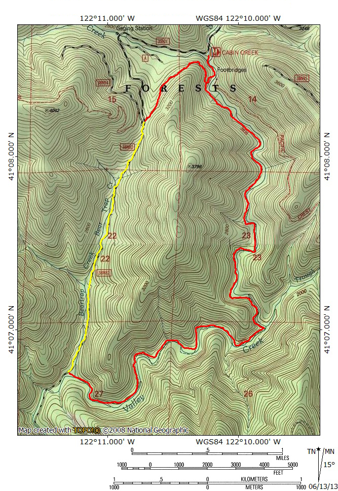
The Squaw Valley Creek Trail proper follows the eponymously named creek for 5 miles to its confluence with Bear Trap Creek. This means, of course, that a simple out-and-back hike can be undertaken. However, there are two better options possible. First is a shorter out-and-back hike is possible covering only the first 3 miles of the trail. All of the essential highlights of the trail come in those first three miles. Beyond this point the creek and its canyon, though certainly scenic, do not produce any new surprises or sights. The other option is to deviate from the trail near the trailhead, follow the Pacific Crest Trail for 1 mile and then hike the remote road that parallels Bear Trap Creek down to its confluence with Squaw Valley Creek. At this point, one can hike the entire Squaw Valley Creek Trail for its entire 5 mile length back to the trailhead, completing a nice 8 mile loop. An added bonus of the loop is that much of the best scenery is near the trailhead and this saves the revelation of these points of interest for the end of the hike, giving the trip a bit of a climax. This description of the trail will start with a brief overview of the first, short option followed by a full treatment of the loop option.
3 mile out-and-back option

A small cataract on Squaw Valley Creek.
For hikers not looking for a lengthy endeavor, the best way to see the highlights of the Squaw Valley Creek Trail is to only hike the first three miles of the trail. This permits hikers to enjoy the first scenic 0.5 miles where the creek flows through a rocky gorge and then tumble through its canyon for the next 1.5 miles. About 2 miles from the trailhead a waterfall becomes audible. Obvious use trails lead down to the small, 10 foot waterfall. There is a nice small pool for swimming in at the base of the falls. This is one of the highlights of the whole trail. Beyond the waterfall, the trail continues for another mile, staying close to the creek nearly the entire time before finally coming within earshot of another small waterfall. Again, obvious use trails lead down to a vantage of the falls. Smaller than the first, the falls is only 4 or 5 feet tall. However, the canyon has narrowed significantly and gotten quite rocky around the falls so that the waterfall is pouring through a fairly tight space. This heightens the drama of the small waterfall significantly. This is a good spot for a picnic. Turn around here and begin the trip back to the trailhead.
8 mile loop option

PCT bridge over the creek.
Hikers looking for a longer and more varied trip, the loop option has is a great choice. By combining the Pacific Crest Trail, the road along Bear Trap Creek and the Squaw Valley Creek Trail a very scenic loop offers a fair amount of variety without having to retrace one’s steps. To begin, hike south from the trailhead, crossing a bridge over diminutive Cabin Creek. From here the trail and Squaw Valley Creek maintain the same course for 0.1 miles until it reaches the junction with the Pacific Crest Trail. At this point the creek drops through a narrow, rocky gorge. The PCT crosses over the gorge on a wooden bridge with interesting construction. It is one of the more memorable sights of the trail. Although it is worth walking onto the bridge and looking down into the creek, do not cross it. Following the PCT in this direction leads to Ah-Di-Na Camp on the McCloud River. Stay straight on the trail and pass the bridge. Another 0.1 miles leads to another junction. This time, the PCT breaks away to the right and the Squaw Valley Creek Trail continues to follow the creek to the left. To take the loop option, turn to the right and follow the PCT as it climbs out of Squaw Valley Creek’s canyon. Soon the trail swings to the left and climbs through the upper reaches of Cabin Creek’s watershed. Eventually the trail widens and follows an old roadbed for a ways.

Dense canopy over Bear Trap Creek.
About 0.9 miles from the junction with the Squaw Valley Creek Trail a sign mounted on a tree indicates the PCT’s arrival at “the Octopus”, a nexus of trails and dirt roads. This is the highest point of the entire hike. Turn to the left and head down the main road. The PCT turns to the left and climbs up a different dirt road for a short distance before reverting back to single track. A short distance from the Octopus a gate blocks vehicles from descending down Bear Trap Creek’s canyon. Simply hike down the road as it stays alongside the creek. The first mile of the road maintains a fairly steep grade and will make hikers glad they tackled this part of the loop first. Notice how there is little to no water in the creek bed at the head of the canyon. As it drops deeper into its canyon seeps and springs feed an increasingly larger creek. About halfway down the road the canyon narrows and the creek is brought right up against the roadbed at a very tight choke point. Shortly after this a significantly tributary joins Bear Trap Creek and increases its size substantially. Throughout the first part of the trip down the road a dense canopy of small tree blocks views of the creek. After the choke point the creek is visible more often. Finally, after 2 miles from the Octopus, the road crosses over the creek. A couple hundred yards further up the road a sign indicating the Cabin Creek Trail is on the left, where the trail joins the road. It is possible to stay on the road a little further to where it crosses over Squaw Valley Creek to see the creek as it heads down toward the McCloud River.

Lower elevation section of Squaw Valley Creek.
Once on the Squaw Valley Creek Trail, it immediately provides the sounds and some views of the creek. The trail passes through oak woodlands with a few conifers adding some variety. It passes through a few grassy areas that are filled with wildflowers in the spring. The wooded canyon is often visible high above the creek. The trail winds its way through the small drainages that feed into the creek, staying in forest cover for the most part. This section of trail is scenic, as it is invariably close to the creek, but it has one enormous drawback: there is a lot of poison oak. The stuff is pretty thick along the trail in places and requires a lot of vigilance to avoid it. The combination of the repetitive nature of the scenery combined with the presence of so much poison oak is why this section of the trail is not essential, despite its proximity to Squaw Valley Creek. Eventually, 2 miles from the junction with Bear Trap Creek Road, the roar of a small waterfall becomes audible. An obvious path leads off to the right and provides access to a vista overlooking the small cataract.

The larger waterfall on Squaw Valley Creek.
Back on the main trail, the path continues to follow the creek. At one point there is a seeming junction with a trail splitting off to the left. The main route straight ahead is now block by wood debris. Stay to the left as it climbs over a small knoll. This recently constructed section of trail is bypassing a section of the Squaw Valley Creek Trail that collapsed into the creek. The collapse is visible from the junction of the original trail and the new detour. Proceeding on the path, the sound of yet another waterfall becomes audible a mile from the first one. Again, an obvious path drops down to the left and leads to an overlook of the waterfall. Though guide books bill the falls at 15 feet, it is closer to 8-10 feet high. It is still an attractive sight and adds a lot of interest to the normal creek scenery. A small pool at the base of the falls is a good spot for a quick dip in hot weather.

Squaw Valley Creek.
After the waterfall, the trail stays close to Squaw Valley Creek for two miles back to the trailhead. There are periodic side trails that lead down to the creek. Typically, the creek is lined with dense bunches of Indian Rhubarb that has attractive pink flowers in the spring. At this point there has been a transition in the type of forest the trail has passed through. When the trial began at Bear Trap Creek it passed through a dominantly oak forest. By the time the route reached the second waterfall, the forest has become dominated by conifers, mostly the usual suspects of ponderosa pine, douglas fir and cedars. However, the trail passes through some of the finest stands of Pacific Yew found in the Mount Shasta area. This type of tree looks like an odd combination of madrone and coast redwood. These trees can also be seen along the trails that follow the Sacramento and McCloud Rivers, though neither have Yews as impressive as those found along Squaw Valley Creek.

The creek passes through a rocky gorge.
As the trail nears the trailhead it veers away from the creek for the first time. After this it approaches the creek again and passes one of the most scenic sections of Squaw Valley Creek. The creek passes through a series of narrow, rocky gorges. At the beginning of the gorge section there is a prominent use trail leading to some viewpoints above the gorges. From here, it is only a short distance back to the junction with the Pacific Crest Trail. As one passes the bridge at the beginning of the trail it becomes apparent that the rocky gorge crossed by the bridge is part of the sequences of rugged little canyons through which the creek passes. Beyond the bridge, it is only a short distance back to the trailhead, completing the 8 mile loop.
Directions
From the main intersection of Highway 89 and Squaw Valley Road in McCloud, drive south for 6 miles. Turn right onto a dirt road signed for Squaw Valley Creek. Proceed for 3 miles on this well-graded road to the large, signed parking area for the Squaw Valley Creek Trailhead.

Pingback: Mount Shasta Area Waterfalls: McCloud River Waterfalls | Hike Mt. Shasta
Pingback: Wild Water: The 5 Best Hikes On Rivers And Creeks | Hike Mt. Shasta
What a sweet hike and pleasant surprise. We actually took the trail toward Squaw Valley Creek instead of up the hill PCT/Trinity Divide. Beautiful walk – until we reached the road going back up. Almost 2 miles of fairly steep road, about 1000 feet climb, to get back to the PCT and to parking! The road is surrounded by amazing forest but the uphill after the easy 5 mile walk along the river was challenging. Excellent work out and most beautiful. Didn’t see one person either!
Pingback: Squaw Creek Hike | escalatorhikers
Pingback: Off Season Trails: Spring Hiking In The Lower McCloud River Area | Hike Mt. Shasta
Pingback: Shasta Spans: 5 Interesting Footbridges | Hike Mt. Shasta
Loved this hike. Thanks to Hike Mt. Shasta for the incentive to check it out. Here’s a summary of our experience on the trail. http://www.themccloudblog.com/portfolio-view/squaw-cabin-creek-trail/
Pingback: Why McCloud Is An Underrated Hiking Destination | Hike Mt. Shasta
Pingback: Five Trails To Avoid Smokey Skies | Hike Mt. Shasta
Pingback: Two Months Until The Old Ski Bowl Opens | Hike Mt. Shasta
We did the out and back years ago and liked it. But we plan to hike the loop version in early June. Any downside to that time, Bubba? Mosquitos? I’m hoping the Umbrella plant (Darmera sp) will be in bloom along the creek, or do you think it’s too late in Spring? Thanks for your thoughts on this.
The lower section of the Squaw Creek Trail is very overgrown with brush and poison oak. If you want to push through it, it easy to go through, but make sure you go home and use alcohol wipes. Memorial weekend had a trailhead full of cars, but almost everyone must have taken the PCT. We saw about 6 people on the whole loop. A good trail for dogs, even off leash.
Pingback: Fall Color Is Very Erratic This Year | Hike Mt. Shasta
Pingback: A Little More On The Wilderness Aesthetic Here In Mount Shasta | Hike Mt. Shasta
Pingback: Mount Shasta Social Distancing Hikes Part I: Waterfalls | Hike Mt. Shasta
I was heading down Bear Trap Creek but saw NO sign or trail going to the left to squaw valley creek. I kept walking and way too far and had to go back the same way I came up that steep road
Hi!
Just FYI, it is now named Cabin Creek at the parking area. Every single other sign refers to it as Squaw Creek.
It’s a ridiculously beautiful walk.