
At A Glance
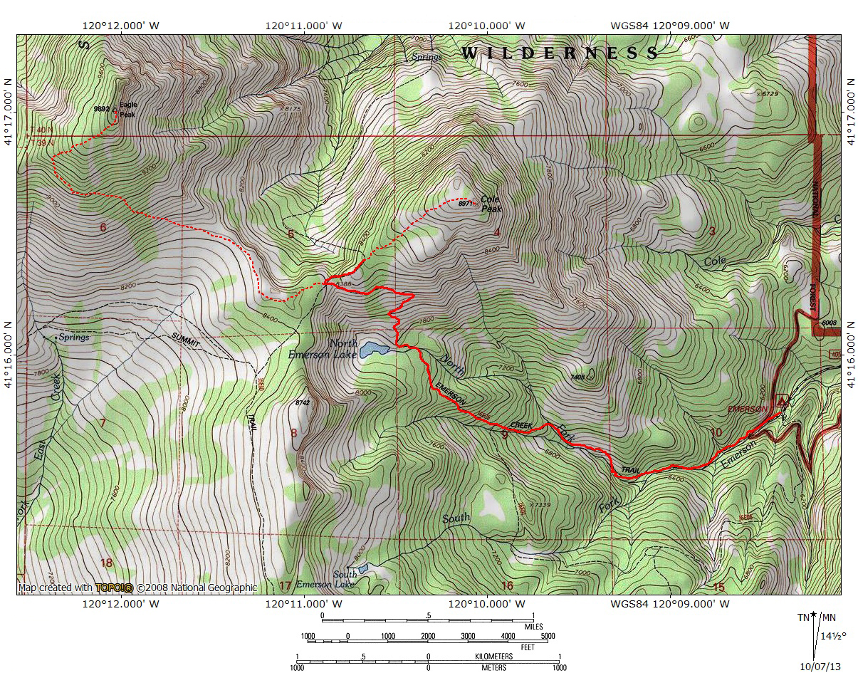
A fairly steep trail that ascends Emerson Creek Canyon on the east side of the Warner Mountains. The trail passes beautiful North Emerson Lake en route to the crest of the Warner Mountains and fantastic views. Peak baggers can continue on to easy Cole Peak or massive Eagle Peak, the highest Point in the Warners.
Total Distance: 4.6 miles (to North Emerson Lake), 6.3 miles (to Warner Crest)
Elevation Gain: 1,880 feet (to North Emerson Lake), 2,500 feet (to Warner Crest)
Season: Summer, Fall
The Lonely Lake

The Warner Crest from the end of the Emerson Creek Trail.
The Warner Mountains are California’s far northeastern mountain redoubt. Blessed with a fair amount of anonymity, it is a range that is usually deemed too far from population centers to attract much attention. Consequently it is seldom used and a haven for those who seek out the places less traveled. The irony is that, while few make it to the Warners, it is not because the range lacks exceptional scenery. Indeed, these are among the finest, most spectacular mountains in California. This is a bold statement in the state of the peerless Sierra Nevada, magnificent Mount Shasta and primeval Klamath Mountains. Yet the Warners, in all of their isolated beauty, still manage to impress even the most jaded of mountain explorers. This is in large measure a result of the Warners’ unique combination of geology and flora. The mountains are located at the nexus of the Great Basin desert ranges, the Cascade Range and even the northern fringes of the Sierra Nevada. The mix of these three influences gives that range a distinct character unlike anything else in the Golden State. As interesting as it is, the flora is really just a complement to the incredible geology. The Warner Mountains are basically a giant fault block range that has been pushed up through an area that experienced a long series of lava flows. Consequently, the range is volcanic but it is not a volcano. The Warners’ tortured, fascinating geologic history makes for incredible hiking and backpacking, a place of tremendous vistas, massive mountains, gorgeous lakes and nourishing meadows. It is a place that both humbles and exhilarates.

North Emerson Lake.
The best place to experience that magic of the Warner Mountains is South Warner Wilderness. This area has both the most exceptional scenery and the most well-developed trail system. The Emerson Creek Trail is a steep ascent into the South Warner Wilderness backcountry. It is the only trail that accesses the wilderness area from the remote east side. The Warner Mountains have a dramatic, sheer eastern escarpment and consequently the Emerson Creek Trail gains elevation swiftly. The trail is attractive and reasonably well maintained. It parallels various forks of Emerson Creek for most of its duration, although views do not really open up until shortly before reaching North Emerson Lake. The lake, though not large, one of the prettiest lakes in the Warners, second only to stunning Patterson Lake and possibly Cottonwood Lake, though the latter comparison is certainly debatable. However one ranks it, North Emerson Lake is a top-notch destination in its own right. Coupled with the astounding views of the Warners at the Emerson Creek Trails’ terminus at the Warner Summit Trail, the trip along Emerson Creek is one of the best trails in the North State, enhanced by the feeling that hiking this trail is truly a journey through territory seldom explored.
The trail is most often used to reach the North Emerson Lake, but it is also the primary means of climbing the summit Cole Peak. The route can also be used to summit Eagle Peak, the Warner Mountain’s highest point. Although the last portion of the ascent is quite steep, it is in many ways preferable to the normal route up Eagle Peak, since the summit is only 5 miles distant from the trailhead. The Poison Flat Trail, the standard route to the summit of Eagle Peak, is 8 miles long, requiring a total distance of 16 miles compared to the Emerson Creek Trail’s 10 miles.
The Trail

Looking back down Emerson Creek Canyon.
The Emerson Creek Trail begins at an elevation of 5,900 feet, just west of the Emerson Creek Campground. The trail follows Emerson Creek, crossing the creek three times in the first 0.5 miles. The trail initially passes through mixed fir and pine forest, occasionally punctuated by aspens. Shortly after the third creek crossing the trail passes out of the woods on a south-facing slope. This area is covered in sage and bunchgrass and dotted with old, gnarled mountain mahogany. The creek is now far below the trail and conifers still abound along its shores and on the north-facing slopes. Views to the south are good, but brief, as the trail crosses the creek again, turning south briefly to round the nose of a ridge. At this point the trail is passing from the North Emerson Creek drainage into the South Emerson Creek Drainage. Almost as soon as the sound of the northern fork fades the crashing waters of the southern fork become audible. The trail continues west, now well above the south fork of Emerson Creek. 0.25 miles from the creek crossing, the trail reaches a junction with the South Emerson Trail. Those wishing to make a loop out of the return trip can take this trail to add an additional 1.5 miles to the total distance. The South Emerson Trial is an attractive trail, though it’s maintenance is spotty in places. Diminutive South Emerson Lake can be reached via a 0.75 mile 800 foot scramble branching off of this route.

North Emerson Lake.
From the trail junction the trail continue to climb the ridge dividing the north and south branches of Emerson Creek. Views of Cole Peak to the north begin to improve, though the trees still obscure any wide-open vistas. As the trail bends north, it levels out, the first real level stretch along the whole route. After another turn to the west, the Emerson Creek Trail finally reaches North Emerson Lake, having climbed almost 1,900 feet in 2.5 miles. Though not as large as some of the lakes found in the northern part of the South Warner Wilderness, the body of water is still a good fishing and swimming destination in a beautiful, rocky cirque basin. The best campsites at the like are found at the eastern end, on the northern and southern sides of the lake’s outlet. At the outlet, note the small dam constructed of large rocks. Though North Emerson Lake is a natural lake, 19th century shepherds constructed the dam to raise the water level. The lake’s large cirque is interestingly diverse. The south side is heavily wooded with white bark pine. The west end of the cirque is a classic, craggy cliffs that rises 1,000 feet above the small lake. This is strangely contrasted against the north side, which is cloaked in more sagebrush and bunchgrass. This landscape in particular seems out of place when contrasted with the lake. The best way to observe the changing landscape is to hike the use-trails that ring the small body of water.

Emerson Peak, North Emerson Lake and distant Nevada.
When it is time to finally depart North Emerson Lake, the Emerson Creek Trail begins climbing out of the cirque just before reaching the outlet. It makes five sweeping switchbacks before leveling off on a long traverse just below the rim of the cirque. The grade is fairly moderate as the trail climbs. Thankfully, this section of the route crosses the open sagebrush and bunchgrass covered slopes on the north side of the lake. Consequently there are excellent views of the lake, Emerson Creek Canyon and rugged Emerson Peak, which looms to the south over the broad Emerson Creek watershed. In the distance, the southern end of the Surprise Valley can be seen far below. The endless folds of the Great Basin’s mountain ranges extend toward the horizon. Finally, about 0.75 miles from the outlet and almost 650 feet above the lake the Emerson Creek Trail terminates at it’s junction with the Warner Summit Trail. From here there are exceptional views of the rugged crest of the Warner Mountains to the north. The striations in the range’s massive eastern escarpment are evidence of successive lava flows. Towering Eagle Peak seems close enough to reach out and grab, while remote Dusenberry Peak is to the north, on the horizon. Far below is the Eagle Creek Basin. The Warner Summit Trail descends into the basin and continues to Owl Creek Basin and finally Cottonwood Basin, where one can either climb up to Patterson Lake or continue northward on the Squaw Peak Trail.

Eagle Peak rises above Cole Peak.
To reach Cole Peak, simply turn east at the trail junction and follow the ridge leading to the summit. There is not trail but travel is easy across the grassy slopes. It is necessary to pass through stunted lodgepole pines, but they are only temporary interruptions to the grassy topography. The route to the top is 0.75 miles long and gains 700 feet in elevation. Spectacular views await. The route to the top of Eagle Peak, the Warner Mountains’ highest peak is much more difficult than the trip up Cole Peak. From the junction with the Emerson Creek Trail, continue south on the Summit Trail for 0.25 miles. Turn west and leave the trail. The desired route follows the base of a low knob, traveling west and then turning to the north, where one reaches the precipice of a cliff, high above Eagle Basin. Follow the rim for a level 0.25 miles to where the mountain begins to rise in earnest. The terrain becomes exceedingly steep from here on. If one desired to simply climb to the summit, it is possible to do so from here. If a more gradual approach is desired, traverse the southern slope of the mountain, traveling in a westerly direction, gaining elevation as one goes. When the western ridge is reached, turn sharply to the east and follow the ridge to the summit. This route is roughly 2 miles long and gains 1,400 feet from Cole Saddle.
Directions

Looking down on North Emerson Lake.
From the intersection of Highways 299 and 395 in Alturas, continue east on Highway395. 5.5 miles from the intersection, veer right onto Highway 299. This road will climb through the Warner Mountains, crossing over Cedar Pass, which has particularly good views of Warren and Squaw Peaks to the south. After descending into the town of Cedarville, turn right onto County Highway 1. Continue south, passing through the small town of Eagleville. 1.3 miles after passing through the town veer right onto Emerson Road. The pavement swiftly fades, but the road is easily traveled by sedans, unless particularly muddy. Stay on Emerson Road for three miles until it dead-ends at the Forest Service campground. The trailhead is west of the campground.
If Eagle Peak is the intended destination, the drive to the Emerson Creek Trailhead is only about ten minutes longer from Alturas than the drive to the Poison Flat trailhead, so if one is willing to make the climb, this is an excellent option.

very good