
At A Glance
A spectacular scramble up a lonely mountain that boasts isolation, fascinating geology, rugged terrain and incredible views of Mount Shasta.
Total distance: 3.3 miles
Elevation gain: 1,550 feet
Season: Summer, Fall
Awesome Obscurity
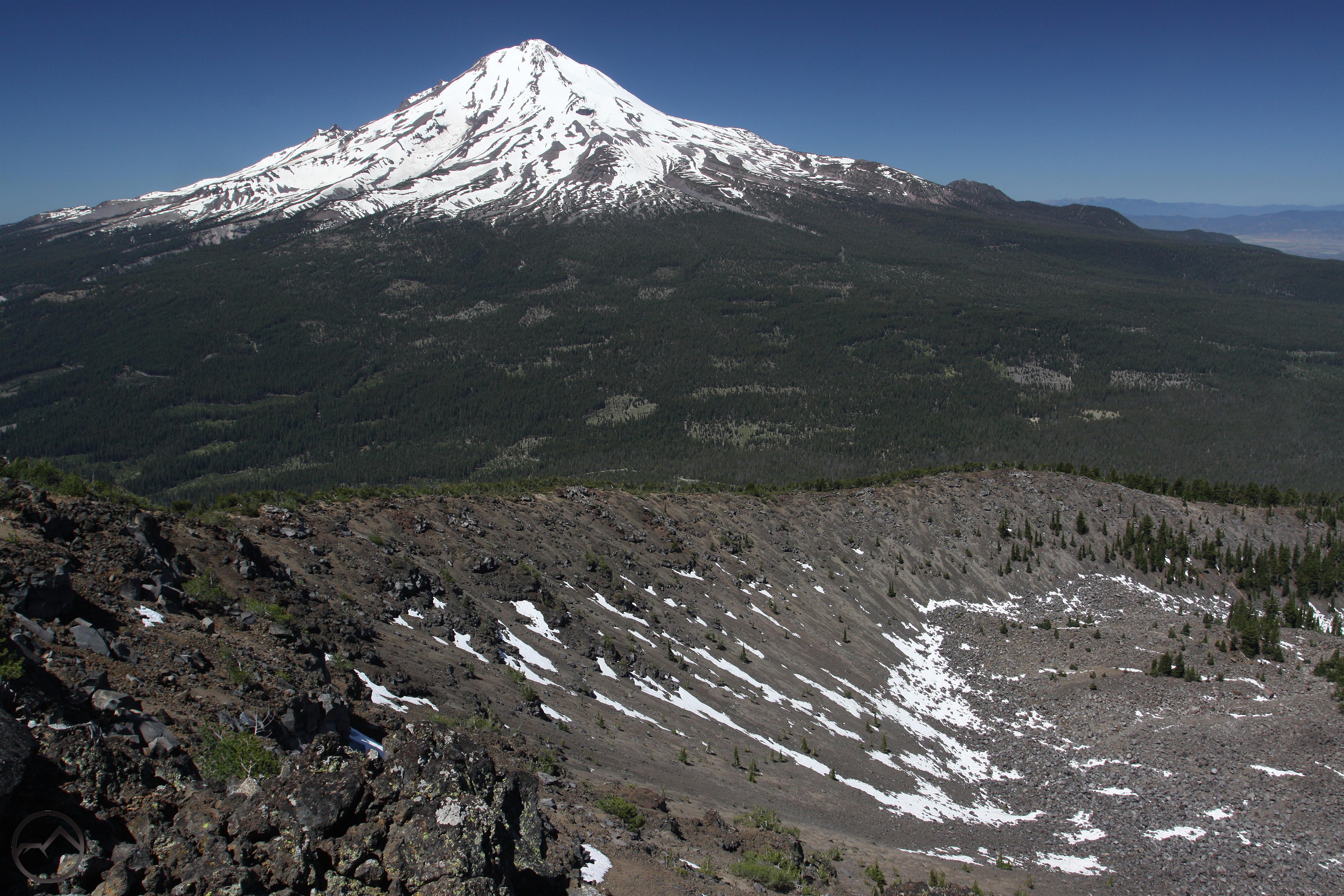
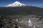
Mount Shasta towers above the Ash Creek Butte rock glacier.
The east side of Mount Shasta is the most remote and forsaken side of the great mountain. Unseen from highway or community, it is often a great blank spot on the mental map of the mountain’s aficionados. Its obscurity extends beyond the Mount Shasta itself and envelopes the surrounding peaks and valleys of the Cascade Range. Rising prominently above this unappreciated tangle of ridges, meadows and deep forests is Ash Creek Butte, one of the tallest and most interesting peaks in the Mount Shasta area. In an area where the mountains are generally rounded summits, Ash Creek Butte is notable for its break with the area’s template. Massive craggy rock outcroppings, tall rocky cliffs and a towering summit jutting into the sky are some of this awesome mountain’s characteristics. Yet, despite the great beauty, fascinating geology and incredible views of the surrounding region, Ash Creek Butte remains off the beaten path. Despite the obscurity, this is classic Cascades terrain, with lots of exposed volcanic layers, tall, rugged peaks, lakes (though these do not lie on the route to the top), hoodoos and views of a gargantuan stratovolcano. This does come as a price though. The trip to the top of Ash Creek Butte has no trail. There is a use-trail, but it is faint and unmaintained. For experienced hikers, these should not pose problems and the scramble to the top of the mountain is one of the finest summit ascents, and best views, in the Mount Shasta area.
The Trail
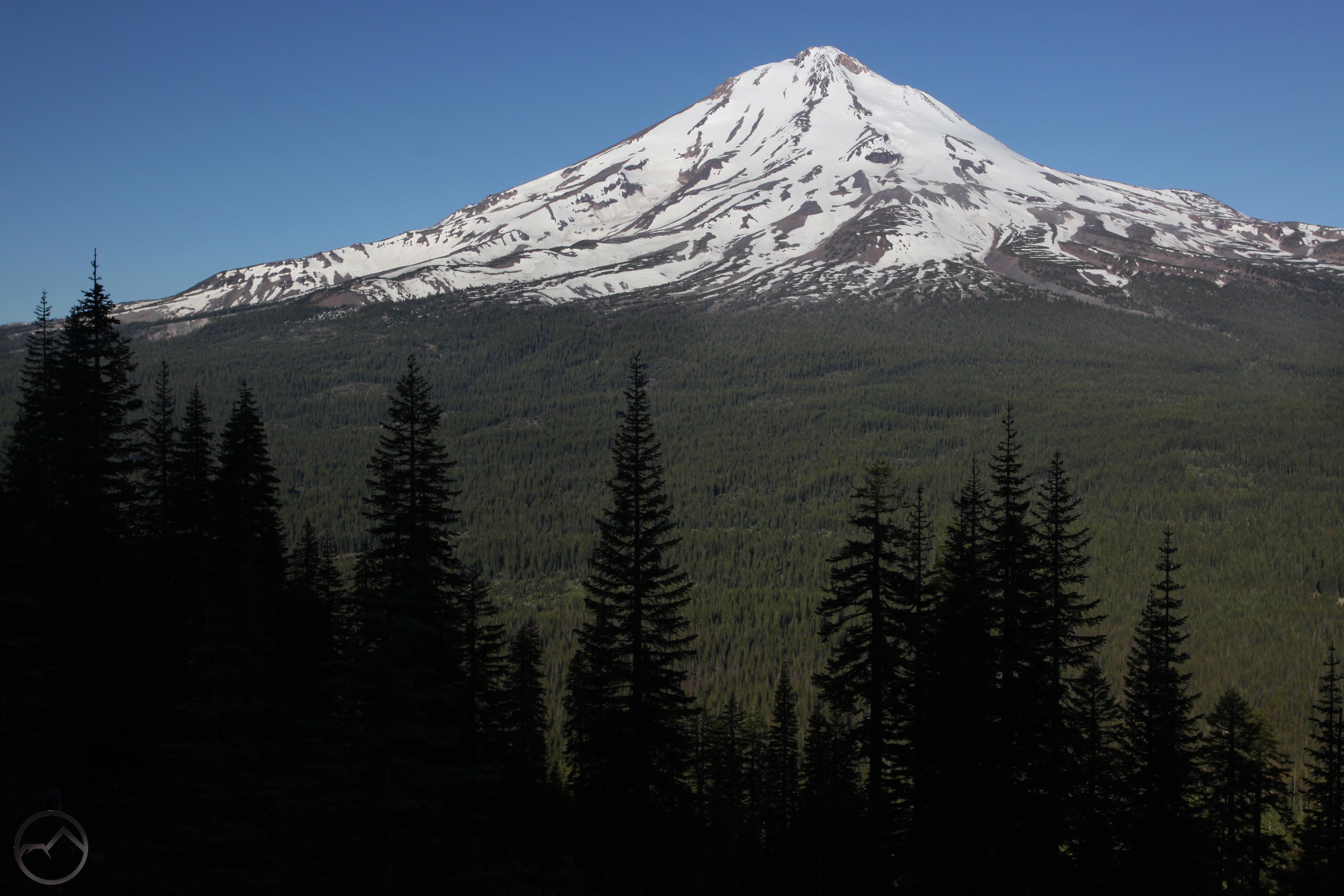
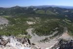
Morning view of Mount Shasta from the logged area.
The hike to Ash Creek Butte begins in the large clearing at the end of the spur off of FR 40N70. For those who did not make the drive all the way to the end of the road, it will be necessary to walk along the road for nearly 1 mile to get the clearing. Once at the clearing take note of a large clear cut that is bordered by a pristine, old growth forest on the ridge rising high overhead immediately to the east. To climb Ash Creek Butte from here, it is necessary to climb to the top of ridge. There are two ways to accomplish this. The most direct route is to simply scramble cross country straight up the ridge. If the goal is to reach the top as quick as possible, this is a slightly better option. Be sure to stay out of clear cut, which is choked with debris from the logging activity. This area was logged a long time ago, but much of the detritus, in the form of broken branches and stumps, remains. The other option for climbing the ridge is to ascend through the logged area, making use of the old paths pushed through the debris by tractors. This may sound like the less pleasant option, but it is actually an excellent route up to the ridge. First it does have discernable track to follow for those who prefer not to go cross country. Second, the clear cut is not hideous, since nature has already started to do what it does: heal. Third, and most important, it boasts a spectacular view of Mount Shasta nearly all the way to the top. The tracks can be a bit confusing, since they form a web climbing up the steep slope. However, remain focused on the top of the ridge and follow the path that seems to make the most progress. The paths will ultimately get there. In the meantime, enjoy the awesome views of Mount Shasta while there is no tree cover in the logged area!
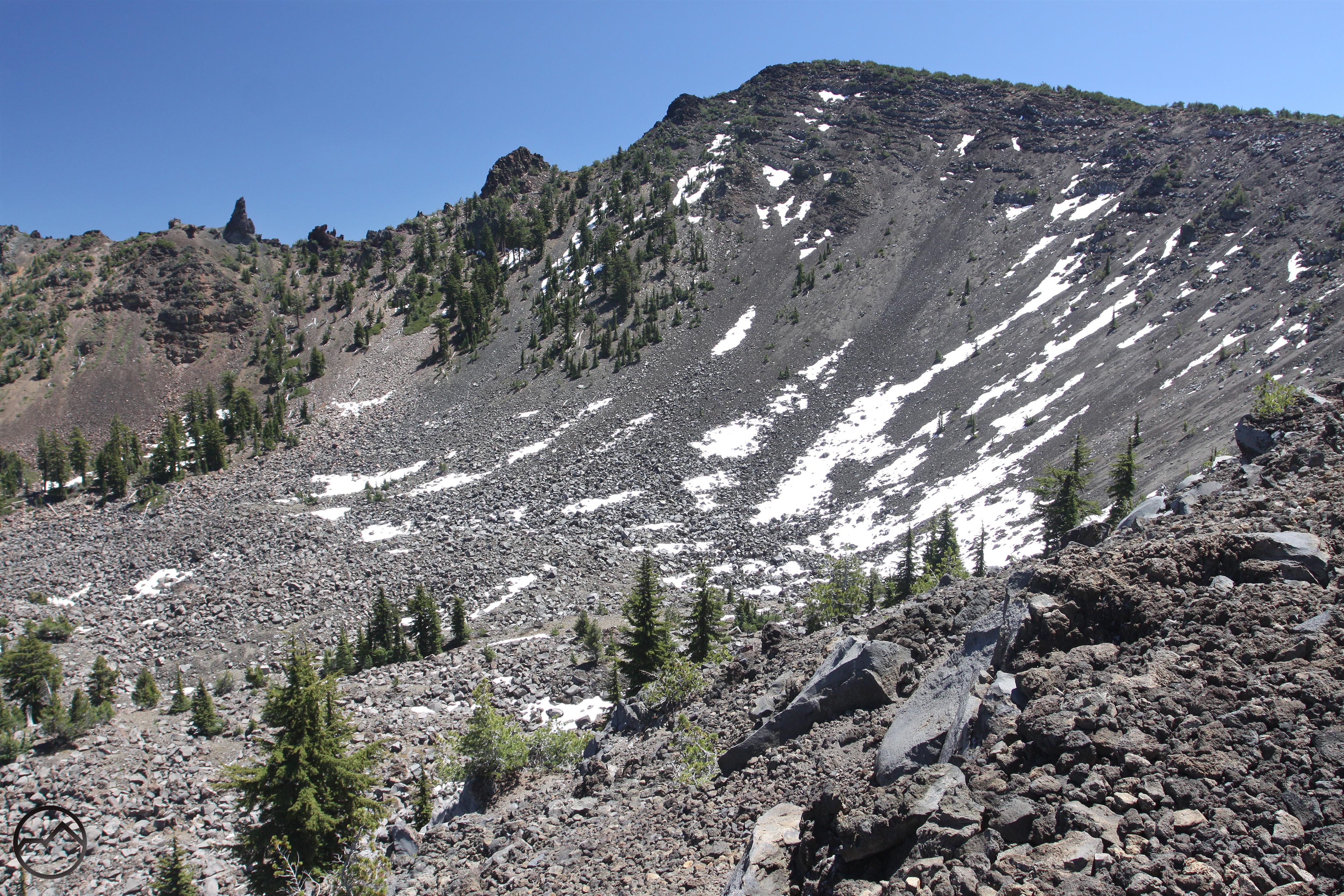
The ridgeline route to the summit of Ash Creek Butte.
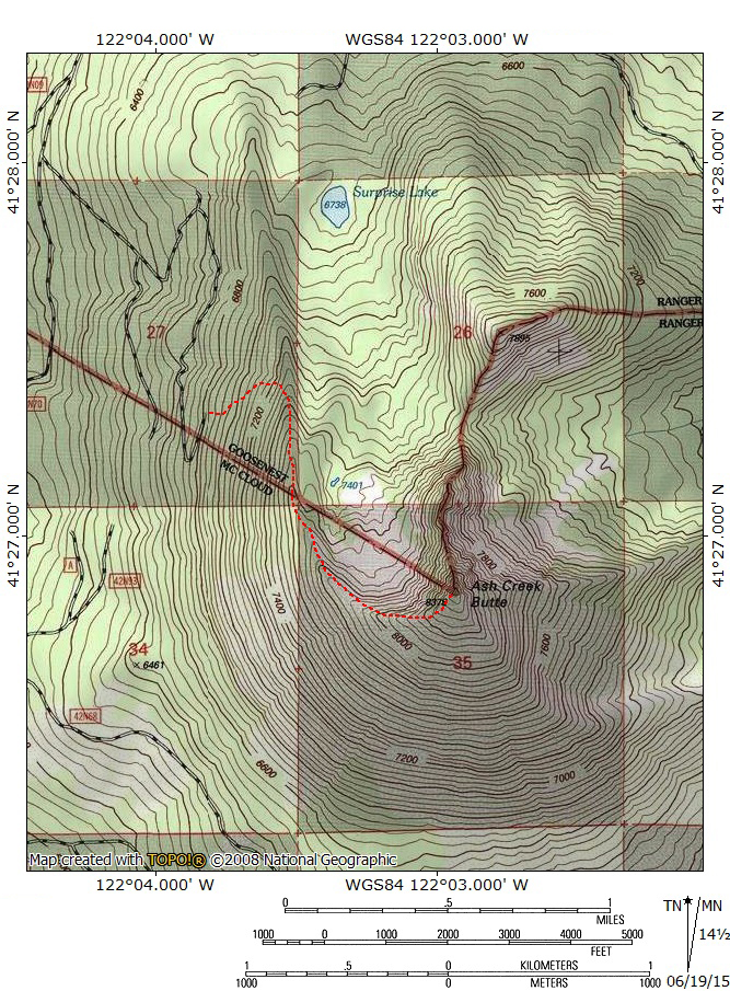
Once on the top of the ridge, the real adventure begins. For those who climbed through the clear cut, there is an old logging road at the top. Turn south and follow it until it fades out. Watch for cairns marking the route beyond the end of the road. If the preferred route was to climb straight up the ridge’s steep slope, it is likely that the route will hit the top of the ridge after the logging road has ended. If this is the case, turn south at the crest and begin climbing. Whichever route was followed, cairns will mark the way south and a faint path will soon be obvious. After a short distance, views into Ash Creek Butte’s massive north-facing cirque will open up and hikers will be able to gaze down onto the giant screefield. Though Ash Creek Butte is volcanic, this is not a crater. It was formed by heavy glaciation. A similar formation exists on the east side, though the cliffs below the summit are much higher and there is less talus. The summit rises impressively to the south, towering high above the rocky basin. The route from here is obvious: follow the ridgeline all the way to the summit.

Good views of Mount Shasta while climbing.
The climb is gradual at first but steepens as it gets closer to the top. This part of the ridge has a high concentration of hemlocks. Be sure to stay right on the edge of the cirque’s rim. It often looks as though there are paths veering away from the rim but these will inevitably run into dense brush and it will be necessary to backtrack. Along the crest of the rim, the route will be clear of brush and there will be constant views into the cirque, as well as of the summit of Ash Creek Butte and to the north, toward the Whaleback and other mountains along the Cascade Crest. Mount Shasta is visible through a thing barrier of white bark pine. It is never much trouble to pause and walk to the other side of the trees to get a view. As the route climbs, it remains close to the edge but the exposure is minimal and there is never a significant danger of falling. Be sure to keep an eye on the crags and the large hoodoo on the far side of the cirque. These are classic Cascade’s features, reminders of the mountains volcanic past. Near the top of the climb, the path cuts southward, away from the edge for the first time. This is because the elevation has finally gotten high enough to get out of the zone that manzanita and other types of brush thrive in. The trees are also shorter since the conditions up here are harsher. Though they are not small, kummholz trees, they do allow great views of Mount Shasta near the end of the hike. Just below the summit, the view south opens up, making for a dramatic panorama as the climb concludes.
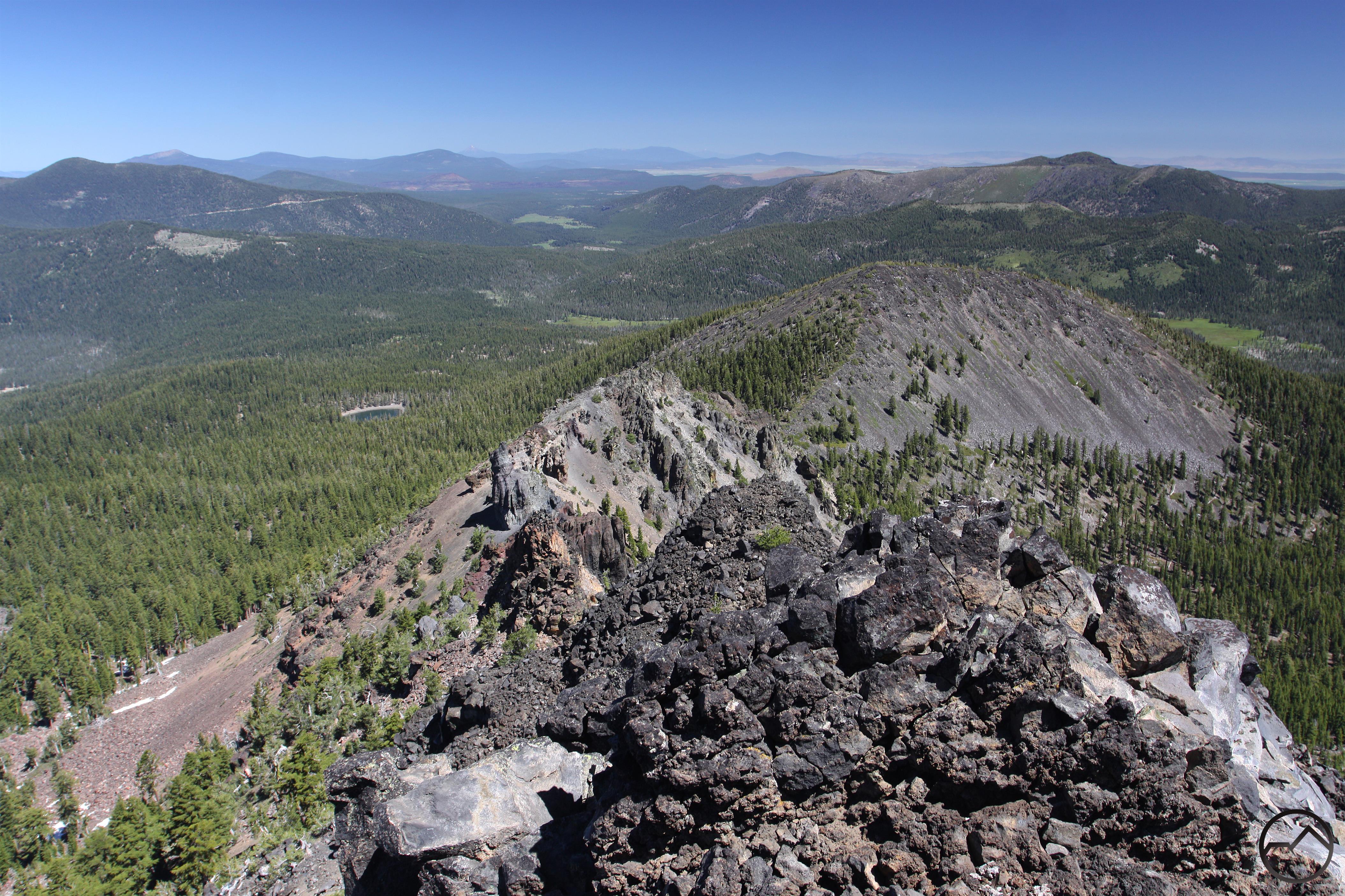
Volcanic geology line the view north from the summit.
The summit vista from Ash Creek Butte is staggering; it is one of the best in the Mount Shasta region. The great bulk of Mount Shasta dominates the horizon but there are an incredible number of other sights that must be examined. First is the view immediately to the east. The east face of Ash Creek Butte falls away precipitously with another rock glacier flowing out from the foot of the cliff. The mountains to the east include rarely seen Dry Creek Peak and Rainbow Mountain. The Medicine Lake Highlands are visible beyond them and even Squaw Peak, Warren Peak and Eagle Peak in the distant Warner Mountains can be made out clearly on the horizon. To the south the southernmost Cascades climb high. Burney Mountain, Crater Peak and all the denizens of the old Mount Tehama’s ruins lies about Lassen Peak. The view north is equally impressive. Much of the Shasta Valley, the Red Buttes, the Marble Mountains and even Preston Peak make an appearance to the west of the Cascade Crest. Due north, the Whaleback and Goosenest are obvious while further still, in Oregon, Mount McLoughlin, the Mountain Lakes Caldera and the Sky Lakes can all be seen. Immediately below the north side of the summit is the large rock glacier, the large crags and the volcanic hoodoo. Even rarely visited Surprise Lake is revealed. Yet it is still Mount Shasta, the great mountain, that draws the eye. Unlike other perspectives of the mountain, the one from Ash Creek Butte shows no hint of Shastina. Consequently, Mount Shasta is rendered a single cone of enormous size. Given the ubiquity of Shastina from almost every other angle, this is the most “unshasta” like perspective of Mount Shasta. Thankfully, many other landmarks are still visible. Chief among them are the enormous Hotlum and Wintun Glaciers. Enjoy the remarkable sight for a while, then return by the same route to the trailhead.
Summit Vistas (click to enlarge)
-
- Summit vista from Ash Creek Butte
-

- Looking down on the large hoodoo on Ash Creek Butte.
-
- The view east from the summit.
Directions
From Weed:
From downtown Weed, drive east on Highway 97 for 11.1 miles. Turn right onto Deer Mountain Road. This is a good, paved road, which is also labeled as FR 19. Proceed 18 miles on FR 19 to the junction with FR 42N70. Though it is initially paved, this road eventually becomes a dirt road but is very well maintained and suitable for all types of vehicles. Once at 42N70, turn right and begin climbing. The road is still in good shape and passenger cars should have no trouble on it. Continue 1.4 miles to an unmarked junction with a road turning sharply right, to the southeast. Turn right and drive up the increasingly rugged road. The road will switchback after 0.5 miles After another 0.25 miles, the road reaches another switchback. The road is easily passable beyond this point for high clearance vehicles. To continue, stay on it for another mile, completing one final switchback before reaching the end of the road at the unmarked trailhead. For those in lower clearance vehicles, park at the second switchback and walk the road for a mile to reach the trailhead.
From McCloud:
Drive east from the main McCloud intersection on Highway 89 for 3 miles. Turn left onto Pilgrim Creek Road and proceed for 7.4 miles. This road will remain paved until it intersects Road 19, which is Military Pass Road. This intersection is signed for North Gate and Brewer Creek. Stay on Road 19 for 7 miles as it twists around the base of Sugar Pine Butte. Though dirt, the road is in pretty good condition and maintained fairly regularly. After 8.5 miles on Road 19, turn right onto FR 42N70 and begin climbing. The road is still in good shape and passenger cars should have no trouble on it. Continue 1.4 miles to an unmarked junction with a road turning sharply right, to the southeast. Turn right and drive up the increasingly rugged road. The road will switchback after 0.5 miles After another 0.25 miles, the road reaches another switchback. The road is easily passable beyond this point for high clearance vehicles. To continue, stay on it for another mile, completing one final switchback before reaching the end of the road at the unmarked trailhead. For those in lower clearance vehicles, park at the second switchback and walk the road for a mile to reach the trailhead.

Pingback: Why McCloud Is An Underrated Hiking Destination | Hike Mt. Shasta
Awesome hike, completely alone, three boys from Michigan on one from AZ. However, bad misprint in the directions. It should read 42N70 for the turn, not 40N70. We spent one hour back and forth on those dirt roads trying to find it before taking a chance and turning up 42N70, which is the correct turn.
Pingback: 5 Trails To Peaks Around Mount Shasta | Hike Mt. Shasta
Pingback: A Major Milestone For Hike Mt Shasta | Hike Mt. Shasta
Pingback: Gazing Into The Heart Of Mount Shasta | Hike Mt. Shasta