
At A Glance
A lonely and scenic hike on the Pacific Crest Trail around a remote high mountain basin. The journey ends at pretty little Bluff Lake and the bizarre formation called the Cement Bluff.
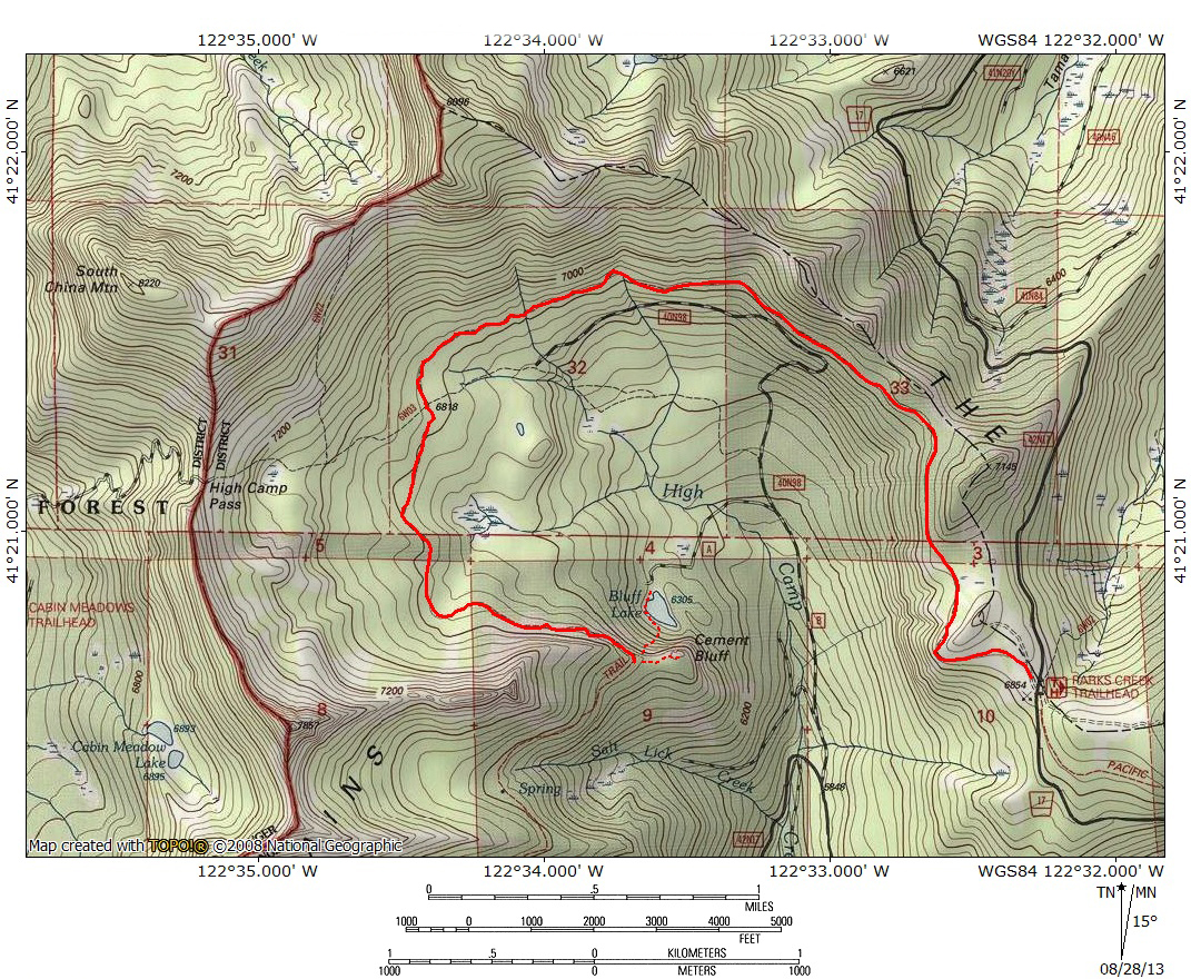
Total Length: 9.2 miles
Elevation Gain: 250 feet
Season: Summer, Fall
Beauty In The Bizarre

China Mountain sits in the distance beyond Bluff Lake.
The Scott Mountains are among the lesser known of the Klamath Mountains’ subranges. They stretch westward from China Mountain (the 4th highest peak in the Mount Shasta area) for nearly 30 miles. While the western half of the range is incorporated into the Trinity Alps Wilderness, the eastern half languishes in obscurity. Just south of China Mountain is Parks Creek Pass, which separates the aforementioned peak with giant Mount Eddy. The pass, which is traversed by the Pacific Crest Trail, serves as a popular trailhead for hikers heading south to the Deadfall Lakes and an ascent of Mount Eddy. The section of the PCT that departs Parks Creek Pass to the north is almost completely unused except by PCT through-hikers. This is surprising because the trail, which is easily accessed at Parks Creek Pass by a paved road, is very scenic, maintains an easy and level grade, and leads to a fine mountain lake and bizarre geological feature. Why such a tremendous hiking opportunity is unexploited is a bit of a mystery but for those who yearn for beautiful backcountry that is deeply isolated, the hike on the PCT to Bluff Lake and the Cement Bluff is sure to satisfy.

Lenticular clouds and Mount Shasta from the PCT.
After departing to the north from Parks Creek Pass, the PCT makes a sweeping arc along the edge of High Camp Basin. The basin is almost completely enclosed; High Camp Creek escapes the giant bowl through a fairly narrow gap at the basin’s southern end. The Cement Bluff, though it lies only 1mile away from the trailhead on the opposite side of the basin, requires a 4.5 mile hike to reach it. This is due to the very wide arc the trail takes while circling the basin. Maintaining a very level course, the trail is exceptionally scenic with great views of the Scott Mountains at the beginning and Mount Eddy near the end. Along the way Mount Shasta makes numerous appearances. The trail passes through open forest as well as treeless terrain with beautiful cliffs towering overhead. At the end of the trip hikers are treated to small Bluff Lake with the great oddity of the Cement Bluff looming overhead. The Cement Bluff is so named because of the unusual composition of the cliff, which is formed of calcite accreted to countless large boulders. The name alludes to the aggregate in the cliff, similar to the aggregate used to make cement. While the hike is certainly worth taking on account of the landscape alone, it is the deep sense of isolation and seclusion found in the rarely visited basin that really enhances the trip. This is especially true later in the hiking season, after the summer’s gaggle of PCT through-hikers have moved on. Once they have passed through, the trail is essentially abandoned and solitude waits for the those who seek it.
The Trail

High Camp Peak and Cement Bluff from across the basin.
Depart north from the PCT trailhead at Parks Creek. Though the trailhead may have many cars, it is almost a surety that they are all there for the hike south toward the Deadfall Lakes and Mount Eddy. The trail passes an old quarry on the left before dropping below the crest of the mountains. The route maintains a level grade, slung high on cliffs above High Camp Creek. The creek combines with Deadfall Creek to form the Trinity River. Consequently, High Camp Creek is the Trinity’s northernmost headwaters. Early in the season the creek can be heard far below. The trail soon rounds a large rocky bluff turning west and then north. Unofficially named High Camp Peak, a large red peak flanked by a rocky ridge, and the Cement Bluff are prominent landmarks across the canyon. A sliver of meadow-rimmed Bluff Lake, at the foot of the Cement Bluff is visible for a short while. China Mountain is visible towering above the end of the canyon.

High Camp Peak from just off of the PCT.
The PCT eventually continues north. After a mile of level hiking, the path passes through a small, lush meadow, only 40 feet or so below the crest of the mountains. The area around the PCT is sparsely forested. At times there are no trees at all and the views to the west remain good. Cement Bluff and High Camp Peak are prominent on the far side of the basin while South China Mountain and China Mountain line the basin’s northern perimeter. Though the northern peaks are attractive, it is the west side of High Camp Basin that will hold hikers’ interest. The track is level and the hiking is easy. Soon the PCT begins to angle toward the northwest. About 1.8 miles from the trailhead the path nears a rocky draw on the right. This is the point one would depart the PCT and begin an ascent of China Mountain. The gully is not very obvious from the trail and is initially under forest cover, getting rockier as one climbs.

Park-like forest at the north end of High Camp Basin.
Staying on the trail, the route now orients due west as it rounds the uppermost part of High Camp Basin. Shortly after passing the rocky draw the trail enters dense forest for the first time. The reason for the increase in the number of trees is the trails passage along more level ground. The first half of the journey the trail was slung high above High Camp Basin. At the north end of the giant bowl the terrain is much more moderate. Though the views all but disappear when the trail enters the deeper forest it is still pleasant hiking. This is because the forest, though denser than before, is still fairly open. The ground is grassy and has a park-like feel to it. Continuing west, the PCT crosses a few small creeks which may be dry latter in the season.

Cliffs above the PCT on the west side of the basin.
After traversing the northern perimeter of High Camp Basin for 1 mile the PCT finally begins to turn south. The forest is still relatively thick but the ground is alternatingly covered with grass or small rock fields. The area is not tremendously brushy. Many of the trees are beautiful old growth giants. Occasional views of Mount Shasta to the southeast filter through the trees and at time the rocky ridge that lines the western side of the basin can be seen climbing up toward High Camp Peak. Another larger creek is crossed, which has a fairly dense fringe of grass. About 50 yards away there is another small meadow area. Here the trail crosses a seep which has turned the path into a thick bog. Steer to the right of the bog to find a bypass trail that has developed as hikers seek to avoid the mud. As the trial continues to the south the trees begin to thin out and the views of the cliffs overhead improve.

Unusual white slabs along the PCT.
After proceeding further south from the bog, the trees get even thinner, especially to the right of the trail as the basin climbs ever higher toward High Camp Peak and the cliffs that radiate out from it. Soon a striking series of white slabs appear just above the trail. Though these smooth-surfaced slabs appear to be composed of sandstone, they are probably one of the rock types related to serpentine or peridotite, which makes up the majority of mountains in this area. These slabs seem particularly out of place, like they are some lost fragment of the cliffs around Zion, Sedona or Moab. However they came to be, they mark a distinct transition in the nature of the PCT. Prior to the white slabs the trail passed through normal forest but beyond them the trees come to an end and the trails crosses onto a steep talus slope composed of bright red rocks. The shift is as dramatic as the scenery is breathtaking.

China Mountain and High Camp Basin above red talus.
With the trail now built into the talus slope and the trees having faded away for the most part, the views increase dramatically. Off to the east the upper portion of Mount Shasta is visible rising above the far side of the basin, near where the trail started. Mount Eddy is visible at times as well. Below the trail the talus drops away steeply toward the bottom of High Camp Basin, which spreads out like a sea of trees. To the north, South China Mountain and China Mountain still rise high above the basin. The trail continues south along the slope. At times there are large, rocky outcroppings poking through the loose rock above the trail. Finally, after having circled all the way around High Camp Basin, Bluff Lake and the Cement Bluff creep into view. The view of Bluff Lake is filtered by trees but the upper portion of the unusual cliff that is the Cement Bluff is clearly visible rising above the lake.

Mount Eddy viewed from the top of the Cement Bluff.
The last portion of the PCT just before reaching the Cement Bluff reenters a thin cluster of trees before reemerging into the open. Here the trail makes a sharp turn to the right, where it continues to follow the Scott Mountains to the west toward the Trinity Alps. Rather than following it take the obvious use trail to the right and hike onto the broad summit of the Cement Bluff. Sweeping views of High Camp Basin greet hikers and eroded gullies in the cliff lead the eye down to Bluff Lake nestled 300 feet below. To the south the enormous bulk of Mount Eddy rise like a giant sienna bubble from a sea of green. It is a fine place to sit and enjoy the mighty view.

The Cement Bluff presides over Bluff Lake.
Unfortunately there is no maintained route down to Bluff Lake and the hillside is steep. The quickest way down is to proceed back down the PCT from the use-trail a few yards. There is an prominent gully through the aggregate rich rock that has observable signs of use. Climbing down this gully will lead to an obvious path worn into the hillside. This route is quite steep and not for the faint of heart. An easier though less direct or apparent route is a little further back down the trail. Nothing marks the spot, but there is a point back up the trail about 0.2 miles or so where the brush has crept nearly up to the PCT for the first time. From here climb down and pick a route through the brush. The way gets more obvious as one proceeds and it should not be necessary to do any bushwhacking. If the route has been negotiated correctly then hikers will reach level ground near a large stack of cut tree trunks. The north edge of the lake is about 70 yards to the right. Though most of Bluff Lake is ringed by trees the northern end has a small lush meadow. There are a few great campsites here with memorable views of the great cliff of the Cement Bluff. The scale is a bit difficult to appreciate but the rocks protruding from the cliffs are several feet across. While not the most spectacular location, Bluff Lake and the Cement Bluff are certainly among the more unusual destinations in the Mount Shasta area.
Directions
From Mount Shasta City, drive north on Interstate 5, through the town of Weed. Exit at the Edgewood/Stewart Springs exit. Turn left and drive under the freeway, then turn right onto Old Stage/ Old 99. Continue north for a couple hundred yards and then turn left onto Stewart Springs Road. After 4 miles, Forest Service Road 17 splits off to the right. Follow this road to the Parks Creek trailhead.

Pingback: Great Scott! Two Scott Mountains Hikes On The PCT | Hike Mt. Shasta
Pingback: Three More (Shorter) Trails For Memorial Weekend | Hike Mt. Shasta
Pingback: Three More (Easier) Trails For Memorial Weekend | Hike Mt. Shasta
Pingback: Gumboot And Parks Creek Passes Open | Hike Mt. Shasta
Pingback: PCT Spotlight – Cement Bluff | Hike Mt. Shasta
Pingback: Cement Banks And Flooding Rivers: A Quick Look At The Geology Of The Sacramento River | Hike Mt. Shasta
Pingback: Wild Concrete: Exploring The Scott Mountains And Trinity Divide’s Cement Formations | Hike Mt. Shasta