

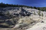
The Hole In The Ground.
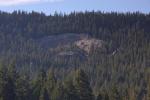
Though it is not obvious from most vantage points, Mount Shasta is not actually on the crest of the Cascades as the range travels from the Lassen region northward into Oregon. The actual crest of the Cascades lies just to the east of the great mountain, running through the area dominated by peaks such as Ash Creek Butte, the Whaleback, the Goosenest and Willow Creek Mountain. Ironically, the truly classic Cascade landscapes are most apparent around the outliers like Mount Shasta, which lies to the west and the Medicine Lake area, which lies well to the east of the crest. Of course, many of the high peaks along the central spine of the range exhibit plenty of volcanic features but for the most part, the core of the range consists of a long series of wooded peaks and ridgelines. Hidden away in these seemingly interminable forested mountains on the east side of the Willow Creek Mountain lies one of the most unique, mysterious and utterly unknown volcanic features to be found in Northern California. The Hole In The Ground Geologic Area, despite its stark and unusual beauty, has managed to stay completely off the radar and rarely sees any visitation. Needless to say, lack of awareness or popularity among the interested public does not necessarily translate into a lack of great beauty and interest.

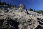
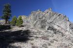
The central tower of the Hole In The Ground.
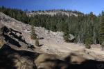
All of this begs the obvious question: what is the Hole In The Ground? The answer to that question is at once easy to describe and yet totally elusive. The formation itself is obviously volcanic in origin. Set in the midst of the great sea of green that is the northern most section of the California Cascades, the Hole In The Ground appears to look like an obliquely angled crater. This is particularly true when viewed from afar and must be the genesis of the formation’s name. When viewed up close, it does not resemble a hole in anyway. On the contrary, it appears to be an exceptionally rugged, rocky amphitheater set against a steep and heavily forested ridge. Dominating the entire formation is an oddly sculpted rock tower that is about 75 feet high. Though its genesis is uncertain, it is strikingly similar to the volcanic necks found throughout the Rio Puerco Valley in New Mexico (though those towers are much larger than the one in the Hold In The Ground). Behind the tower are a series of rocky walls that hem in the formation. Radiating out from the tower are beautifully arid badlands. This aspect of the Hole In The Ground seems particularly out of place compared to the lush forest that surrounds this bizarre feature. Amazingly, a small series of springs emerge immediately adjacent to the badlands. Though often only a trickle, the mossy seeps producing the water stand in stunning contrast to the barren landscape of the rest of the Hole In The Ground formation.

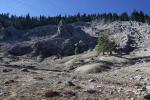
The barren beauty of the Hole In The Ground.
Still, the question regarding the formation of this beautiful anomaly lingers. Just how did this striking and strange volcanic feature come to be? What little information on the Hole In The Ground comes through the Forest Service. Surprisingly, the Forest Service implies that the creation of the Hole In The Ground is a mystery. They do believe that the original foundation comes from successive lava flows at some point in the past. It is suggested that this particular spot had lava with a different chemical makeup that made the cooled lava more susceptible to decay. It is also claimed that the Hole In The Ground experienced significant mud slides that helped contribute to both the current shape of the formation and to its being revealed in the general. Once the lava was exposed, it is believed that erosion and other mechanical actions like freezing and unfreezing of water shaped the area into its present form. Whether or not that answer is satisfying, the experience of being there is magnificent. The tremendously unusual nature of the place enhances its beauty tremendously.

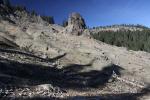
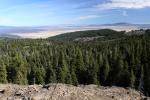
View of the Butte Valley from the Hole In The Ground.
Indicative of its anonymity, visiting the Hole In The Ground is an utterly primitive experience. Though it is not hard to get to, one must know precisely where to go because there is no signage alerting adventurers they have arrived at the formation. One must park along a seemingly random dirt road and bushwhack through the forest before reaching the outskirts of the formation. Hiking around the Hole In The Ground should be done cautiously due to the fragility and sensitivity of the badlands and other geologic features. Still, for those who do venture into this fascinating area, the experience has many rewards. The Hole In The Ground itself is tremendously beautiful and has a strong sense of mystery running through it. Great views of Butte Valley and southern Oregon during the hike in and some rarely visited meadows add to the enjoyment of exploring this unusual area.
As always, if anyone is curious about details in getting to the Hole In The Ground, feel free to send me an email.
-
- The Hole In The Ground Geologic Area

Thanks for sharing! This is indeed an unusual and very interesting geological find.
Wow, that is awesome. Another spot for my ever growing list of places to go!
I think you and I have a similar interest in the things that are not often seen. If you ever head over this way, feel free to give me a holler! My wife and I have a cabin across the street from our house that we use as a guest house. You are welcome to use it if you want to make a base camp to explore this area. Just file that away…
I will thanks!
Would love to have more details getting there. Would one be able to ride around it on horseback?
Or best to just hike it
Shoot me an email if you would like directions how to get there. As far as horses, I don’t think they could get there as it takes a bit of scrambling to reach it. Nothing hard, but not horse friendly. That said, I think even people should tread carefully there. Horses would be rough on the place.
Hi–I would like to go there this week. How do I get there??
Thanks for visiting my blog ColoradoTravelingDucks.com. I love your blog! Fantastic photos. Thanks for showing and telling about the Hole in the Ground Geological area. I never knew. I will visit your site often. Love the mountains and Mt. Shasta is perfect
It reminds me of a plug and rim, sort of similar to Panum Crater near Mono Lake. Good article, and great pictures. I will definitely be checking this place out, when I go to Redding next year.
Pingback: Year One of Hike Mt Shasta | Hike Mt. Shasta
Pingback: Mount Shasta Area’s Seldom Seen Round Up | Hike Mt. Shasta
Pingback: Mount Shasta Seldom Seen Round Up 2015 | Hike Mt. Shasta
Pingback: A Mount Shasta “Seldom Seen” Round Up | Hike Mt. Shasta
Trout lake I know how to get to Montague but once there how can we get to lake? Also SissonCallahan trail that starts off Barr rd on sac river headwaters but where? I’ve had locals here try to find it and have problems. End up cross country walking which is too hard on arthritis ankles. Can you help there as well? Or if you have book or site with more detailed info let us know please. Thought lakes are open year round in calif? Thanks l
Everything you want to know is in this book:
http://amzn.to/2umMafm
ITS PLAINLY A METEOR CRATER , JUST LOOK AT THE MOON , I LIVE ON THE OTHER SIDE OF WILLOW CREEK MOUNTAIN , ON WILLOW CREEK