
At A Glance
A gorgeous trail that passes through lush meadows and aspen groves at the north end of the South Warner Wilderness. Views abound along the entire trail and the highlight is verdant Cottonwood Basin, which boasts a beautiful waterfall. A steep climb out of the basin traverses wildflower covered slopes en route to spectacular Patterson Lake.
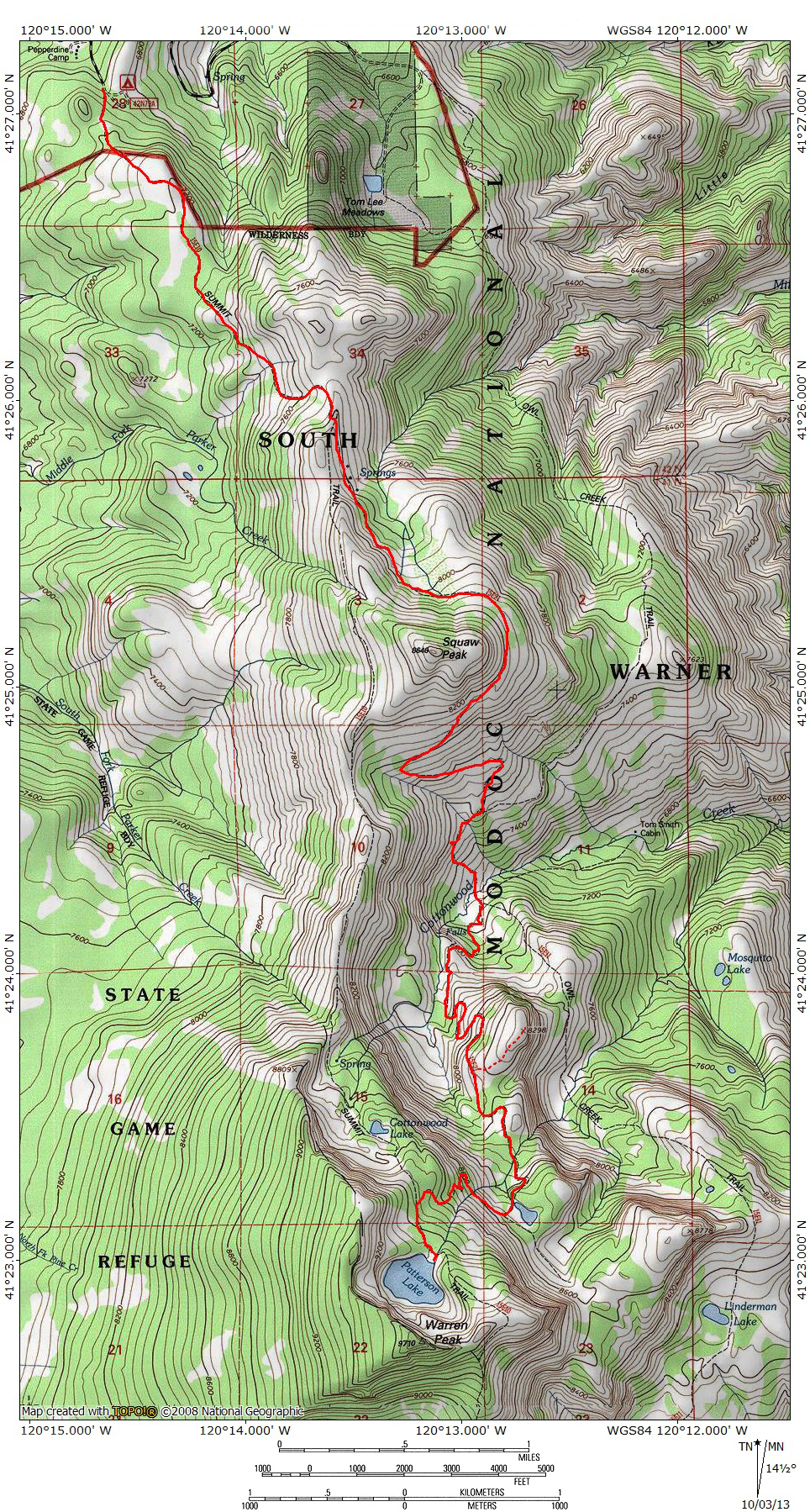
All statistics include the initial part of the Warner Summit Trail which leads to the Squaw Peak Trail. Mileage assumes round trip to destination.
Total Distance: 10 miles (to Cottonwood Basin), 17.35 miles (to Patterson Lake & return via Summit Trail)
Elevation Gain: 1,425 feet (to Cottonwood Basin), 3,104 feet (to Patterson Lake)
Season: Summer, Fall
Aspen Extreme (and vistas, meadows and waterfalls too!)

Squaw Peak looks down on Cottonwood Meadow.
The Squaw Peak Trail is one of the most scenic trails in Northern California. It has spectacular scenery nearly every step of its entire length and accesses some of the prettiest sections of the Warner Mountains, one of California’s remotest mountain ranges. Ironically, the Squaw Peak Trail does not actually climb its namesake mountain. Instead, it travels around three of the four sides of the peak, passing from the north side to the south side. Beyond Squaw Peak, the Squaw Peak Trail climbs up the terraced flanks of the Warner Mountains before emerging on the shores of Patterson Lake, one of the most the most fantastic destinations in the northern part of California. Along the way, the trail passes through several verdant meadows and along numerous creeks tumbling down the Warner Mountain’s remarkably rugged eastern escarpment. The trail begins and ends at junctions on the Warner Summit Trail, so it can be used to form a striking loop, covering some of the most attractive parts of the Warner Mountains. The Squaw Peak Trail is also one of the three trails, along with the Warner Summit Trail and the Owl Creek Trail that combine to form the epic circuit around the South Warner Wilderness.
The Trail

Approaching the junction with the Squaw Peak Trail.
The Summit Trail begins at Pepperdine Camp, which has rudimentary facilities including corrals for horseback riders. The elevation is 6,830 and the forest is typical of the trees of that elevation. Initially the trail climbs through a forest of mixed pine and fir before entering a large clearing. The trail will remain open for most of the rest of the journey, passing through isolated groves periodically. After 0.25 miles, the Summit Trail passes a sign marking the boundary of the South Warner Wilderness. At the boundary the conifers recede and the trail passes through a grove of mountain mahogany. Beyond the wilderness boundary the route continues to climb, passing strange rock formations. The formations are the first indication that Warners are volcanic in origin. The twisted and eroded rock is composed of tufa, hardened volcanic ash that is easily eroded by wind and water. A mile past the wilderness boundary the trail begins to climb more steeply, up a broad grassy slope. Views of Squaw Peak to the south and the Modoc Plateau to the west are excellent. Another 0.50 miles deposits one on the crest of the Warner Mountains for the first time. Views in all directions are glorious. After hiking 0.25 miles along the crest one reaches the junction with the Squaw Peak Trail.

Looking down on the first part of the Squaw Peak Trail.
Once on the Squaw Peak Trail proper, the path drops below the crest of the Warner Mountains as it continues south. After passing some springs and an increasingly deep canyon, the trail briefly enters a thick group of pine and aspen. On the far side of the small wood, the trail again enters open terrain. Below the route is a broad flat bench occupied by a very large meadow. The meadow is the source of Milk Creek, which cascades down into the Surprise Valley far below. The summit of Squaw Peak is visible high above. The route rounds the southern fringe of the meadow before making a broad arc around the eastern flank of Squaw Peak. The terrain is grassy and the views are superb throughout. Once the trail has reached the south side of the mountain, it begins to drop quickly. After 0.5 miles, the path reaches a switchback, turning sharply to the east. As good as the views have been, they are now an order of magnitude greater. The cliffs of Warren Peak and “Cottonwood Butte”, with Cottonwood Creek cascade down them are staggering. Another 0.5 miles results in another switchback, the trail now heading west. Soon the route begins to drop at a faster rate, passing the intersection with the Owl Creek Trail as it makes the final descent into Cottonwood Meadow. The trail finally levels off as it reaches the bottom of the Cottonwood Basin.

Cottonwood Falls.
Cottonwood Meadow is nestled into the bottom of Cottonwood Basin. Lush, grassy meadows are interspersed with clumps of willows and other shrubs. Groves of aspens line the perimeter of the meadow and climb higher up the slopes above the bottom of the basin. Steep cliffs soar vertically above the west side of the basin, rising over 1,600 feet above the meadow. Initially the cliffs are covered with grass and sagebrush, broken up at times by dark rock outcroppings. Higher up, the vegetation gives way to the striated reddish rock along the rim of the escarpment, giving the area a classic Warner Mountains appearance. To the north, the great dome of Squaw Peak lines the horizon while to the south the giant block of “Cottonwood Butte” hems in the northern side of Cottonwood Basin. Through all of this flows tranquil Cottonwood Creek, which meanders through the meadow. The creeks entrance to the basin is not tranquil, however, as it flows over a 100 foot high, two-tiered waterfall. It is a gorgeous scene and one of the prettiest in all of the Warner Mountains. This is a fantastic place to set up camp.

Cottonwood Butte rises above Cottonwood Meadow.
When it is time to continue on the Squaw Peak Trail, one must cross Cottonwood Creek and pass through more meadow on the far side, reaching the junction where the Owl Creek Trail continues on to the south. “Cottonwood Butte” looms high above the junction. The Squaw Peak Trail turns to the west and begins to switchback up the lower flanks of the butte. After 0.45 miles the trail reaches a meadow filled valley. Proceeding south, it passes along the back side of “Cottonwood Butte”. While the peak can be summited from here, an easier and more open route is possible if one continues along the valley and then climbs another set of switchbacks, a distance of about 1 mile. At this point, the trail has reached the southern slope of “Cottonwood Butte”. Reaching the summit is a simple matter of hiking cross-country across the summit plateau to the precipice on the east end of the butte.

Squaw Peak seen from the climb out of the basin.
Resuming the trail, it proceeds south another 0.5 miles before crossing Patterson Creek. Beyond the crossing, the trail skirts an unnamed and sometimes dry lake. Once past the lake, the Squaw Peak Trail begins its final push up the cliffs below Patterson Lake. Wildflowers are profuse throughout this section of trail. At times there are vast swaths of lupine covering small basins and clinging to the cliffs as the trail climbs. It crosses Patterson Creek again and begins switchbacking in earnest through more flower filled meadows. The switchbacks are tight and climb steeply up the cliff. A short distance away Patterson Creek tumbles noisily downward. It is not quite a vertical waterfall but adds a lot of charm to this section of the trail. It finally tops out at the top of the cliff and a short distance away it intersects the Summit Trail, about 0.75 miles from the dry lake. Once on the Summit Trail, it is an easy 0.2 miles to the shore of Patterson Lake, easily the most spectacular spot in the Warner Mountains.

Patterson Lake.
Patterson Lake is the highlight of the Warner Mountains. It is one of the finest lakes in all of Northern California. Conveniently, it is accessed by two other trails in addition to the Squaw Peak Trail. The Warner Summit Trail begins at the same trailhead as the Squaw Peak Trail. From the south, the Pine Creek Trail links up with the Summit Trail just south of Patterson Lake. A pair of short, incredible loops can be pieced together with all of these trails. The longer of the two would involve heading in on the Pine Creek Trail, passing Patterson Lake en route to the Summit Trail’s junction with the Squaw Peak Trail. From there, it is a matter of following the Squaw Peak Trail back to Patterson Lake and Pine Creek Basin. The other option is to start at Pepperdine Camp and access Patterson Lake via the Squaw Peak Trail and then returning via the Summit Trail. Though the former has the benefit of enjoying Pine Creek Basin, the latter loop is more efficient in terms of time spent on the trail and no backtracking. Furthermore, if one has the time to do the longer loop, one might as well do the entire Summit Trail. The Summit Trail-Squaw Peak Loop makes a great introductory trip into the Warner Mountains.
Directions

Along the Squaw Peak Trail.
From the junction of Highway 299 and Highway 395 in Alturas, head south on Highway 395. At the south end of downtown, turn left (east) on County Road 56, which is also named E. McDowell. The road winds for several miles, climbing up to a levee and passing a reservation casino before dropping into a shallow canyon. Views of the west slope of the Warners are excellent. Eagle, Warren and Squaw Peaks are prominently visible. Eventually the road enters Modoc National Forest and becomes Forest Road 31. Although the pavement ends the road is in excellent condition and is passable by sedans. After climbing a few more miles through the forest turn right onto Forest Road 42N79. Look for signs marking Pepperdine Camp. Do not turn left to go to the horse camp but continue straight a short distance to the parking lot at the marked trailhead.

Pingback: Year One of Hike Mt Shasta | Hike Mt. Shasta