
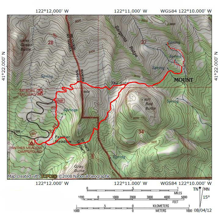
At A Glance
A fantastic trip through Mount Shasta’s barren volcanic landscape ending at the largest meadow complex on the mountain. A wonderful loop is possible on this route.
Total Distance: 4.7 miles (Panther Meadow option), 4 miles (Old Ski Bowl option), 5 miles (loop option)
Elevation Gain: 875 feet (Panther Meadow option), 400 feet (Old Ski Bowl option), 1,275 feet )loop option)
Season: Summer, Fall
The Grand Garden
South Gate Meadow
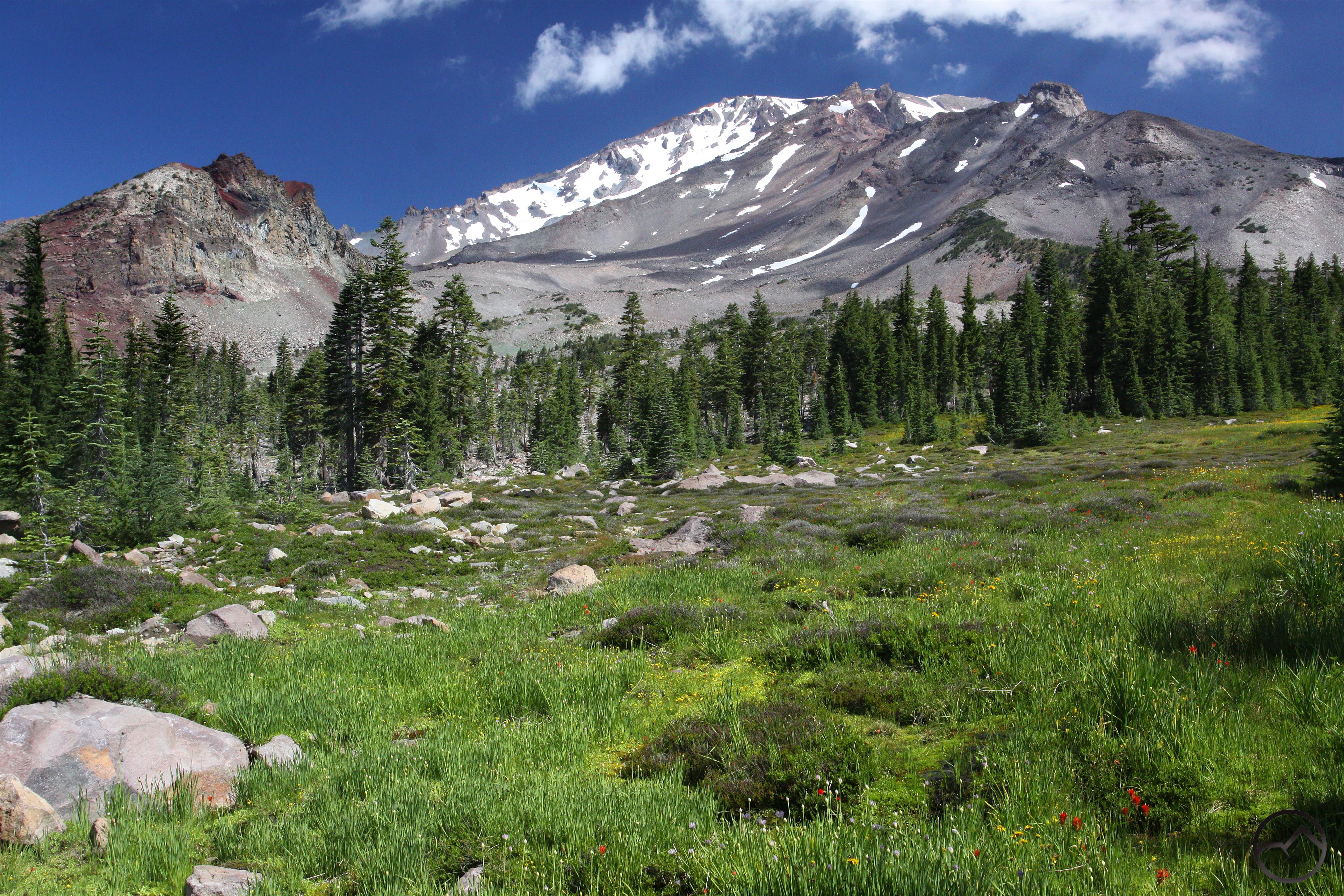
The Squaw/South Gate Meadow Trail is one of the most scenic and interesting trails on Mount Shasta. For a mountain of such epic size and so close to both communities and lines of travel, it is surprising how few developed trails there on Mount Shasta. There are many excellent destinations on the mountain but few are reached by maintained trials. Of the trails that do exist on the mountain, most follow old roads up to tree line and then fade into unmaintained routes used by climbers. The Squaw/South Gate Meadow area is probably the finest destination that is reached by a maintained trail on the mountain. Numerous spring fed creeks beset the verdant meadow. Presiding over this idyllic scene are Shastarama Point, Thumb Rock and the Konwakiton Glacier.

The meadow’s name is the source of some confusion. The creek birthed at the springs responsible for the meadow is Squaw Valley Creek, which flows off of Mount Shasta, through the town of McCloud and into Squaw Creek Valley, beyond which it courses its way into the McCloud River. Consequently, the meadow has traditionally been known as Squaw Meadow. The recent effort to realign names along politically correct sensitivities gave rise to an effort to rename the meadow. Therefore, the name was changed to South Gate Meadow, presumably named after the nearby Gate through which the trail to the meadow passes. This is probably intended to mirror the North Gate Trail on the north side of Mount Shasta. Consequently, South Gate Meadow is the source of Squaw Valley Creek. Many longtime visitors to Mount Shasta continue to refer to the meadow by its traditional name, which is why this page refers to both.
The Squaw/South Gate Trail has two trailheads, one found at Panther Meadow and the other at the Old Ski Bowl. Both trails see a fair amount of use, though the Panther Meadow route seems to be more popular. A loop can also be assembled connecting the two trailheads.
The Trail
This description of the route to Squaw/South Gate Meadow will cover both the route beginning at the Old Ski Bowl and at Panther Meadows. The latter is a little more complicated and will receive a bit more attention to accommodate the potential confusion.
Old Ski Bowl Route
Red Butte seen beyond Hummingbird Meadow.
The trail departs to the north from the Old Ski Bowl, towards the summit of Mount Shasta. There are use trails all around the Old Ski Bowl, but the trail to the meadow is marked with an official trailhead display. Once on the primary trail, the route climbs north a ways and then switchbacks up a few hundred feet towards a gap in the ridge ahead. The ridge is a long spur that split off of Sargents Ridge at 10,000 feet. At the gap, the views are good, particularly to the west. At the top of the ridge one crosses into the Mount Shasta Wilderness. Once on the east side of the ridge, the trail descends toward the Gate, a gap between the south end of Sargents Ridge and Red Butte, a large volcanic dome unsurprisingly composed of reddish colored andesite. While descending towards Red Butte, the trail parallels a small creek flowing through an attractive yet diminutive meadow. The creek may dry up towards the end of summer. The trail from the Old Ski Bowl joins the Panther Meadow route right at the beginning of the Gate. One attractive aspect of this route is that it stays above treeline, meaning there are pretty constant views.
Panther Meadow Route

Mount Shasta towers above Panther Meadow.
Though this is the more commonly used route to get to the meadows, it is a bit more confusing than the Old Ski Bowl route. The trail begins at the Panther Meadow campground, about a mile before the road ends at the Old Ski Bowl. After passing through the campground, the route cuts across Panther Meadow. Upon entering the meadow, there is a signed trail that splits off to the north, heading toward the upper section of Panther Meadows. This trail, along with some cross-country hiking or road hiking can combine the Panther Meadow route with the Old Ski Bowl route to form a very attractive loop. Continuing across the meadow, there are great views of Mount Shasta and a couple of small stream crossing before the trail plunges into a forest of Shasta Red Fir.

The Valley of the Moon.
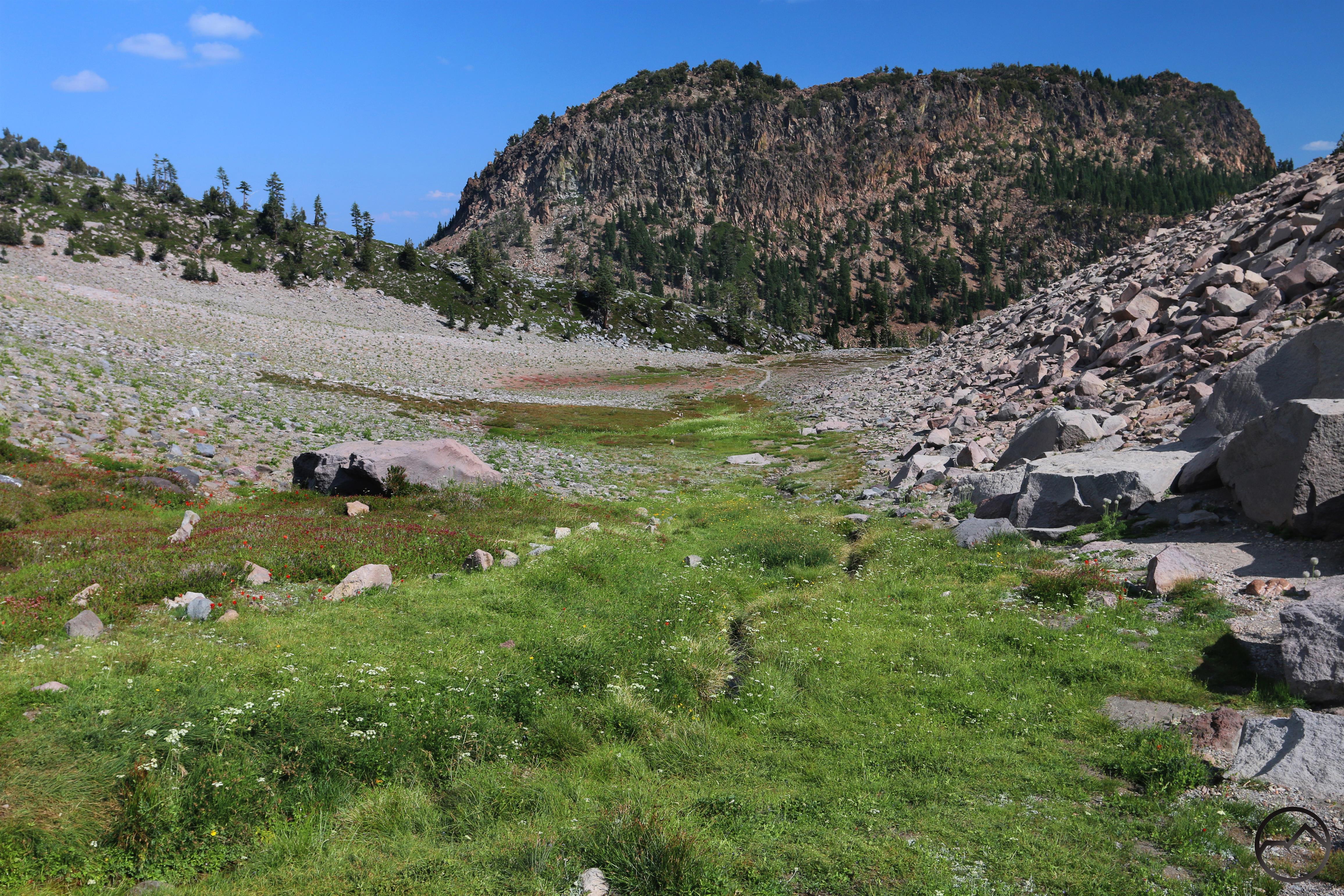
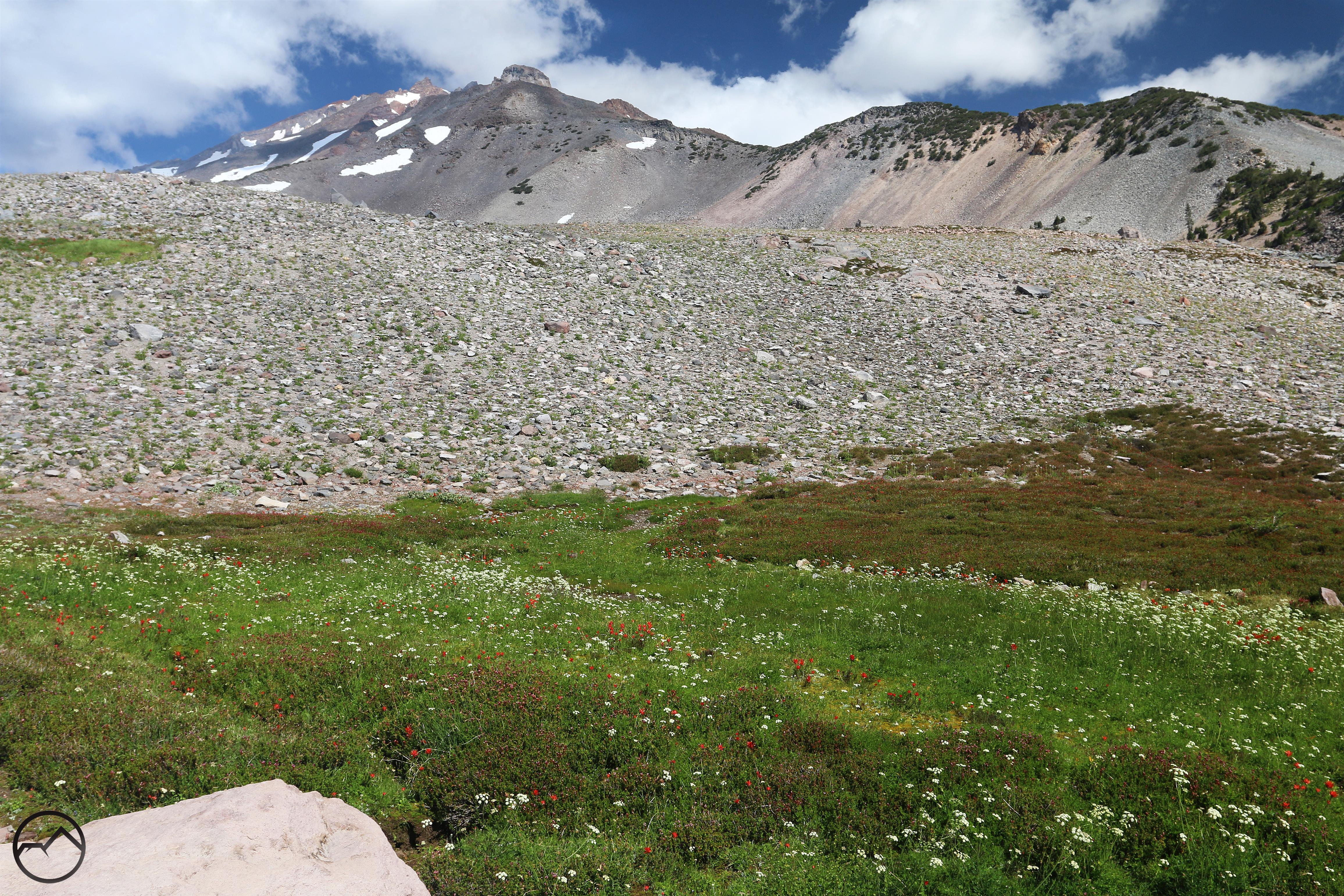
After 0.65 miles, the gradually climbing trail reaches a wooded saddle. Here the trail splits, with the route to the summit of Gray Butte heading off to the south. The Squaw Meadow Trail continues to the northeast. It is at this point that it is possible for confusion to ensue. While the trail is fairly well established, there has been a recent alteration to the route that creates two possibilities to proceed. Originally, the trail reached a set of cliffs that were about 30-40 feet high. Ducks were used to mark multiple route options to climb the cliff and regain an established trail. While this is still an option, a new trail has been developed that heads north, paralleling the base of the cliffs. This route goes about 0.15 miles up the gully before the cliffs subside and the trail is able to climb them easily. From here it is a short distance through the woods before the trail reaches the first really scenic area since departing Panther Meadow. Here, Red Butte rises steeply on the far side of a valley that can only be described as a moonscape. Only isolated clumps of grass and western pasque flower grow here. The trail drops quickly and then cuts through the center of the valley. With the cliffs of Red Butte on the right and Mount Shasta and Green Butte looming on the other side of the valley, it is a barren and memorable scene. On the far side of the valley, the trail climbs briefly to join the trail from the Old Ski Bowl at the mouth of the gate.
South Gate/Squaw Meadow Trail

The cascade that divides the upper and lower meadow.
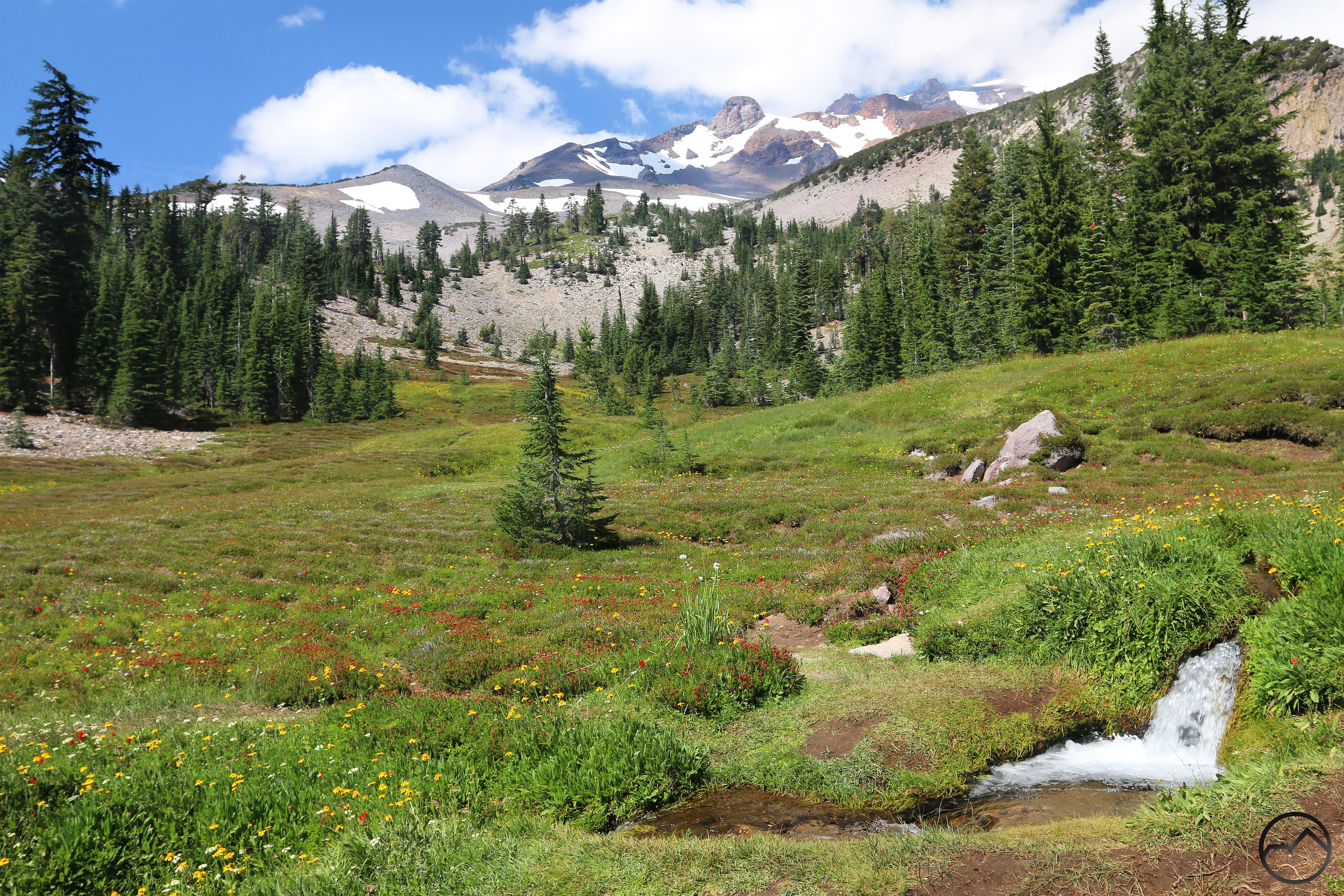
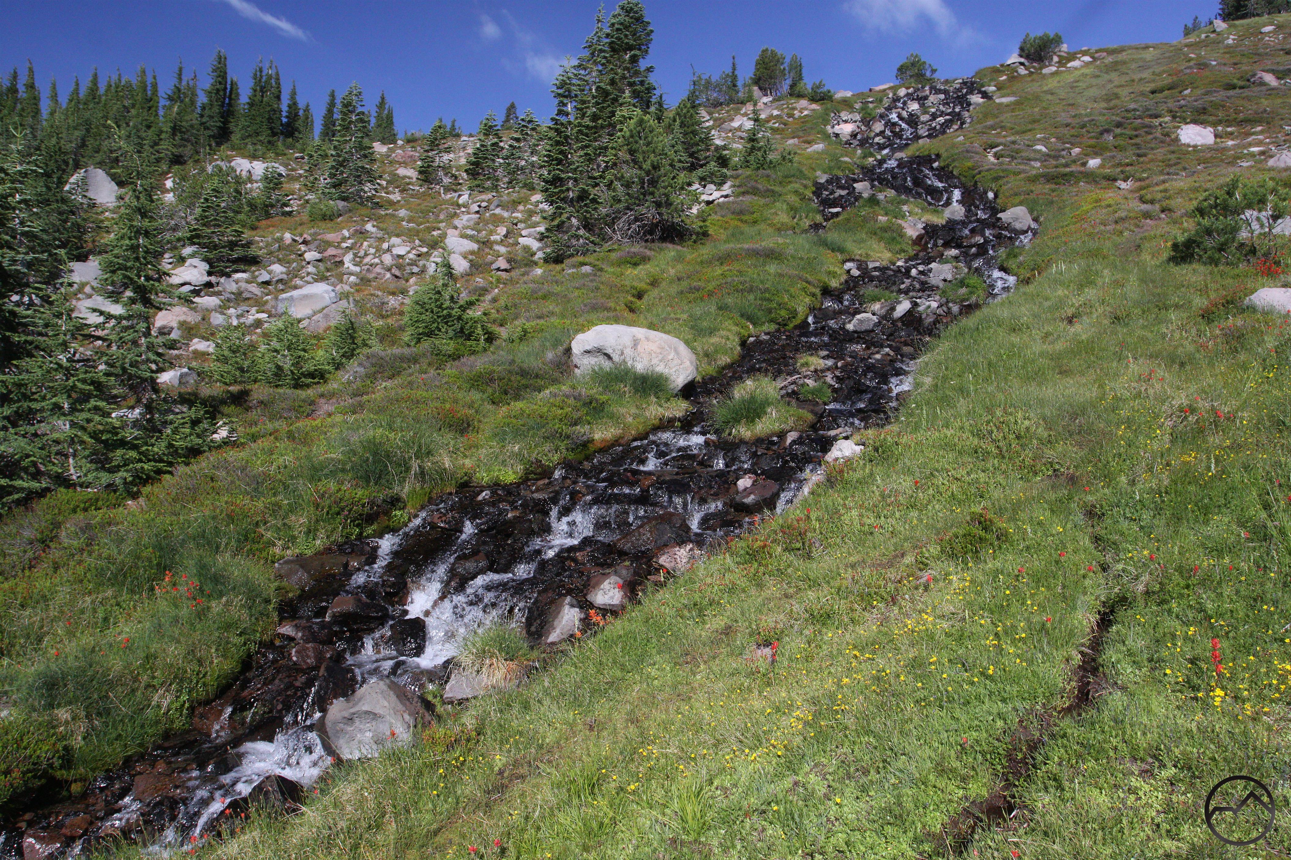
Once the two trails have converged, the combined route descends a short distance into the Gate, a narrow defile between the southern end of Sargents Ridge and Red Butte. At first passing through more level moonscape, the trail soon enters a large boulder field cascading off of Red Butte. Winding through the rocks, the trail begins to gradually drop again. Views to the east are good, and include Black Fox and Buck Mountains. Beyond the boulders the route renters a red fir forest and continues at a fairly level grade for a short distance before finally depositing one at the edge of Squaw/Southgate Meadow. It is an idyllic scene. Prior to this point, the route to the meadow had been under forest canopy or through the spectacularly barren landscape of the Gate. Now lush grass carpets the ground as numerous spring-fed creeks course their way through the meadow. In late July and early August, wildflowers erupt throughout the meadow. Above it all is Sargents Ridge, topped by Shastarama Point, Thumb Rock and the Konwakiton Glacier.
The large cascade in the middle of the meadow.
Although the official trail ends when one reaches the meadow, there are a couple of use trails that head north toward the upper meadow. As much as possible, it is important to stay on these paths in order to avoid impacting the fragile meadow environment. There are two primary routes available. The first, hugging the western fringe of the meadow ultimately fades out when it reaches a small ridge covered by trees. It is possible to bushwhack up the ridge to reach the upper meadow. Instead, follow use trails to the far, eastern side of the meadow. Here a well established use trail follows the main creek through more meadow to a large cascade that descends from the upper meadow. Continue along the trail, paralleling the cascade to reach the upper meadow. Here Shastarama Point looms dramatically over the meadow. It is possible to follow the meadow all the way to the springs that support verdant landscape. Beyond the springs, the ground is barren again, though cross-country travel leads to more dramatic landscapes further up the canyon.

Mount Shasta from the top of the loop.
As previously mentioned, a great loop can be formed by connecting the two trailheads. Although one can start at either trailhead, the Panther Meadow beginning is preferred, since it finishes the loop with a long downhill section and has a climatic conclusion with the massive views to the west while descending down to the Old Ski Bowl and the relaxing passage through Upper Panther Meadow. If returning via Panther Meadow, one must then climb up to the Old Ski Bowl and much of the return is through a dense red fir forest and hemlock. While it is a very nice stretch of trail, it is not quite as fitting a way to end a great hike as the opposite direction.
Mount Shasta and Upper Panther Meadow.
If one starts at the Panther Meadow trailhead end returns via the Old Ski Bowl, there is a fairly well established use trail that descends from the Ski Bowl parking lot to Panther Meadows. On the easternmost side of the parking lot, look for a trail about 10 feet down an embankment. The trail, inside a shallow dry gulch is well established at first, but eventually becomes faint. At this point, follow the dry gulch all the way to the four-way intersection with the Upper Panther Meadow trail. To the left, the trail leads to the springs that supplies the water that sustains the meadow. To the right leads to a small parking area that provides access to the upper meadow. Continue straight through the intersection, passing through a small glade before emerging into the lower portion of Panther Meadow, where it links up with the main trail. Turn right to return to the parking lot.
Directions
Wildflowers at Hummingbird Meadow.
Panther Meadow
From I-5, take the Central Mount Shasta exit. Merge onto Lake St. and head east for 1 mile, passing through the intersection with Mount Shasta Blvd. As the road bends to the north, continue onto Washington Street for 0.1 miles before continuing onto Everitt Memorial Highway. Once on this road, continue for about 12.5 miles to the Panther Meadow Campground for the Panther Meadow trailhead.
Old Ski Bowl
On I-5, take exit 738 for central Mount Shasta. Proceed east on Lake Street, through the intersection of Lake and Mount Shasta Boulevard. The road continues east and bends to the north, reaching an intersection by Mount Shasta High School. Pass through the intersection, which becomes Everitt Memeorial Highway. Stay on the highway for 14 miles to the end of the road, which terminates at the Old Ski Bowl Trailhead.

Pingback: The End Of The Road: Three Hikes In The Old Ski Bowl Area | Hike Mt. Shasta
Pingback: Vistas, Meadows, And Waterfalls: Three Best Hikes On Mount Shasta | Hike Mt. Shasta
I count my fifteen plus camping trips to upper Squaw Meadows over the last twenty years as some of the most enriching and peace-filled days of my 61 years pilgrimmage on this planet. I’ve met many very interesting and spiritually motivated people up there, with only one marginally contentious exception. I behave better than usual up there, too:)
Squaw Meadow is a great place and I hope we all act a little more reverential in a place that beautiful…and that it would cause to carry that out into the rest of our lives.
Have you ever done the hike to the rim of Mud Creek Canyon from Squaw Meadow?
I count my fifteen plus camping trips to upper Squaw Meadows over the last twenty years as some of the most enriching and spiritually motivating times of my 61 year pilgrimmage on this planet. Easy to meet cordial spiritual practicioners up there; have had only one mildly contentious exchange. Flowers and hummingbirds in profusion. I also usually behave better up there, too:)
I have hiked into Squaw Meadow several times this year in August. except for the weekends there were very few hikers there so it was a very peaceful hike. I enjoy the different landscapes as I travel the trail, from very open valleys to heavy forest. As I move on from the upper meadow I head Southwest over the ridge and head to the Andesite rock cliffs and pick up the trail there. There is no trail as so it is very desolate. I then head to the old Ski Bowl on the trail through Hummingbird meadow and then walk the road down to Panther campground. That makes it about a 5 1/2 mi hike.
There certainly are a number of good off-trail routes in the Squaw Meadow area. I think the best is the trip to Mud Creek Canyon but the circumnavigation of Red Butte is great too!
Pingback: Seldom Seen: Mud Creek Canyon | Hike Mt. Shasta
Pingback: Year One of Hike Mt Shasta | Hike Mt. Shasta
Pingback: Lofty Subjects: The Five Tallest Peaks Around Mount Shasta | Hike Mt. Shasta
Pingback: The Perfect Weedkend: Three Days In Mount Shasta | Hike Mt. Shasta
Pingback: Trip to Mount Shasta | Memórias
Would this be considered the best hike on Mt. Shasta?
I would. When you consider the loop option, the consistent scenery, ease of hiking, quality of destination and the potential for lots of great exploring for some extra, spectacular destinations, this is tough to beat. I think that Brewer Creek and Clear Creek are close runners up though.
One of the best. I just hiked up last weekend (August 27) and the flowers were spectacular.
My husband and I are looking into trails to hike this summer. We are not experienced hikers. Would the loop option be doable in approx. 3 hours?
Pingback: A Major Milestone For Hike Mt Shasta | Hike Mt. Shasta
Pingback: Why Right Now Is The Perfect Time To Hike On Mount Shasta | Hike Mt. Shasta
Pingback: Right Now Is The Perfect Time To Hike On Mount Shasta | Hike Mt. Shasta
Pingback: Mount Shasta’s Hummingbirds | Hike Mt. Shasta
Pingback: Old Ski Bowl Projected To Open In A Week | Hike Mt. Shasta
Pingback: Mt. Shasta Diaries: What Goes Up… – Singing in the Shower
Pingback: The Shasta Trinity Wilderness: Full of Surprises | Electric Travels
As someone who has lived in Mount Shasta for the past 11 years, this hike remains one of my all-time favorites. It’s incredibly peaceful, and since few people venture all the way out, you often find yourself alone in the beauty of nature—surrounded by the wild and the unseen elementals. Truly wonderful. The best part is when you start to hear the sound of water as you approach the meadow. The people I have encountered are lovely and those that seem to care about more than the mundane in life.