
At A Glance
A great loop around beautiful Lake Siskiyou that offers up a surprising amount of variety and spectacular views. Sections of the loop are great options for hikes during the off-season.
Total Distance: 7 miles
Elevation Gain: Minimal
Season: Summer, Fall, Winter, Spring
The Loop Around The Lake

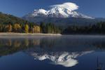
Mount Shasta from the Lake Siskiyou Trail.
Nestled at the foot of the Trinity Divide and enjoying outstanding views of Mount Shasta, Lake Siskiyou is one of the prettiest reservoirs in Northern California. The lake is one of the premier features of Mount Shasta City, a community that boasts cornucopia of outdoor attractions. The lake provides opportunities for swimming, boating, fishing, picnicking, camping and hiking. The last of these activities is made possible by the Lake Siskiyou Trail, which completely encircles the lake. Though this is by far the least wild trail in the Mount Shasta area, it still offers beautiful scenery around the lake and fantastic views of Mount Shasta, Mount Eddy and Battle Rock, the high point of the Castle Crags. The views of Mount Shasta are particularly noteworthy. While there are many amenities scattered around Lake Siskiyou, particularly along the south shore where the Lake Siskiyou Resort offers an extensive campground, a boat ramp, beach and associated stores and restaurants, there is still many opportunities to enjoy the natural setting while hiking around the lake. It is surprising how pleasant a hike at the lake can be given the amenities and the proximity to Mount Shasta City. Still, for the most part, this is not a place to expect solitude on a regular basis. Despite the lack of isolation, if one is willing to accept some company on the trail, the Lake Siskiyou Trail is a great option for an easy hike with extremely convenient access. This is particularly the case in the offseason. When the high country is covered in snow, the Lake Siskiyou Trail still offers hikers the chance to enjoy the outdoors and appreciate spectacular vistas.
Mount Eddy rises above the Sacramento River at the inlet.
Since the Lake Siskiyou Trail completely encircles the eponymously named lake, there is not clear beginning or end. There are, however, distinct sections of the trail that have varied personalities. The north and southeast shores are the most natural and undeveloped portions of the trail. The bulk of the south shore passes through the Lake Siskiyou Resort and is consequently well-developed. The northeast section of the lake passes through the Mount Shasta Resort and along the road that accesses the lake from Mount Shasta City and experiences the heaviest amount of vehicular traffic. The natural result of these very different stretches of trail is the tendency for people to hike sections of the Lake Siskiyou Trail rather than doing the entire loop. This is particularly true of the north shore section of the trail, which has the longest and most undeveloped stretch of trail. It also links to of the more interesting areas on Lake Siskiyou, namely the Wagon Creek Bridge and the Sacramento River inlet. Despite the tendency to hike the trail in segments, this description of the Lake Siskiyou Trail will describe the entire loop around the lake.
Although it is possible to start the trail at any of the six trailheads or at the Lake Siskiyou Resort, this description of the trail will begin at the Box Canyon Dam Trailhead, which is located immediately north of the aforementioned dam. This is the same trailhead for the Box Canyon Trail. This is the best place to start a loop around the lake because (assuming a counter-clockwise circumnavigation) it gets the section through the Mount Shasta Resort and along the busy road over with first, places the Sacramento River inlet as a sort of mid-point highlight and saves the incredible views of Mount Shasta from the southeast corner of the lake as a climax of the entire hike. From there it is a short jaunt back to the trailhead. While the trail can be done in a number of permutations, this pattern puts the emphasis on the trail’s scenic qualities and the fantastic views of Mount Shasta.
The Trail
Beginning at the parking area on the north side of the Box Canyon Dam, the trail heads north along W.A. Barr Road. I like parking at the south end of the parking lot where you get better views of the lake. Walk north through the parking lot for about 100 yards and look for the wide path heading north, running parallel to the road. This is section, stretching to the north for about 0.75 miles suffers the most vehicular traffic and is by far the least natural part of the hike. One of the benefits of starting at the dam parking lot is the opportunity to dispense with the developed area first so as to enjoy the natural setting for the remainder of the hike. Heading north, the wide path passes lakeside cottages maintained by the Mount Shasta Resort while the golf course is visible on the opposite side of the road. About 0.5 miles from the trailhead the Lake Siskiyou Trail passes another trailhead, which is located across the street from the main entrance to the Mount Shasta Resort. From here the path continues north, following the curvature of the road, which is still only a few feet away from the trail. Finally, after enduring the traffic on the road for 0.75 miles, the trail crosses a creek and descends into a narrow gully, finally taking on a natural setting for the first time.

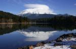
Mount Shasta and the Wagon Creek Bridge.
As the trail drops down into the gully Cold Creek can be both seen and heard. The short creek begins only a short distance to the north, emerging from springs near the fish hatchery. After crossing the creek, the trail switches back and follows the west side of the creek. Soon the rushing waters are stilled as they meet the impounded water of Lake Siskiyou. The trail proceeds west, staying 50 feet or so above the lake. This is the beginning of one of the most interesting and scenic parts of the Lake Siskiyou Trail. As the path heads west, it travels along the spine of a very narrow spit of land that extends out into the lake. At the west end of the spit rises the great arch of the recently constructed Wagon Creek Bridge. For many years the Lake Siskiyou trail was incomplete and a full circuit around the lake was not possible. With the completion of the bridge all sections of the trail are now linked together. The Wagon Creek Bridge itself has become something of an attraction in its own right. This is understandable considering its impressive engineering and size. On the far side of the bridge the trail hugs the lakeshore, staying 30 or so feet above the water. About 0.25 miles past the bridge the trail arrives at the third parking area. Though not part of the official trail, it is good to continue to the south where a narrow peninsula extends out into the water and great views of the lake abound.
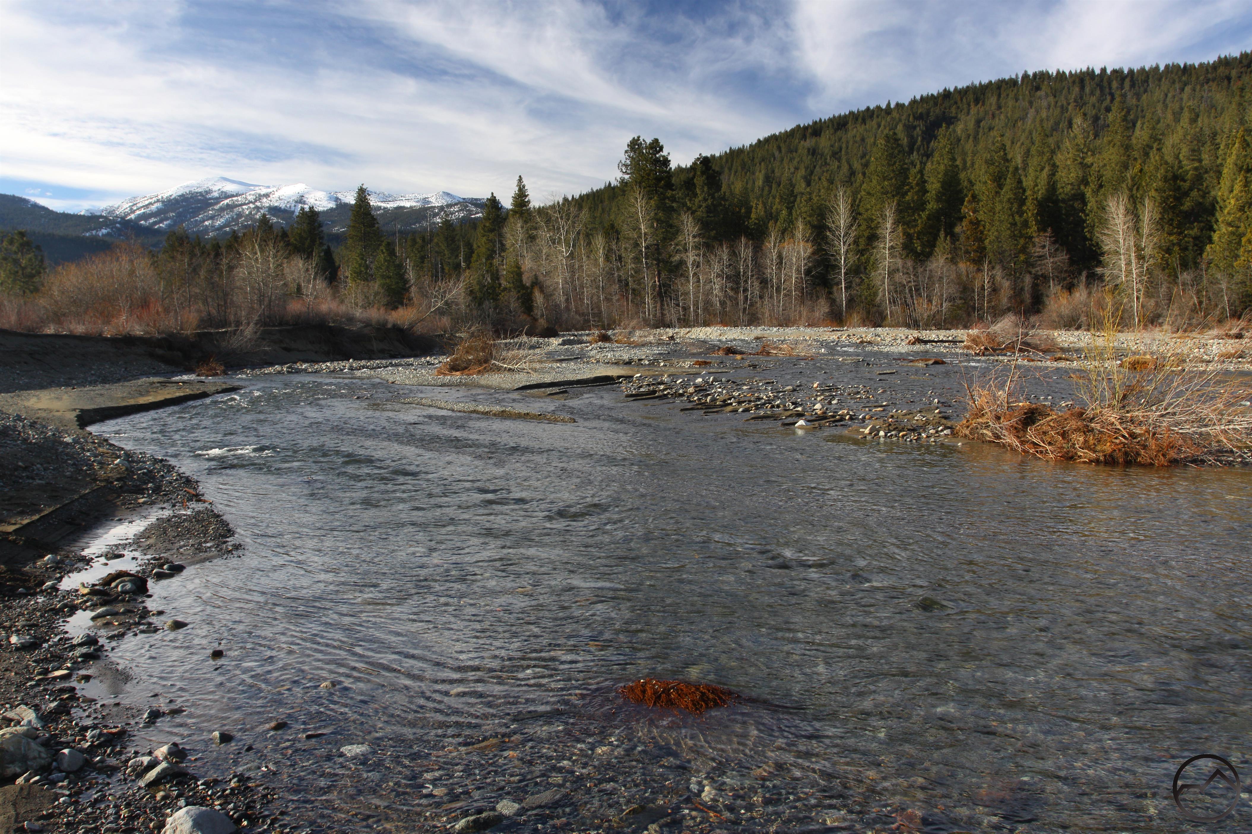
The Lake Siskiyou Trail crosses the Sacramento River just above the inlet.
To continue on the Lake Siskiyou Trail return to the parking lot and look for the trail continuing on the west side. This is the beginning of one of the most scenic parts of the trail. The route passes along the edge of a grassy meadow before making a lazy arc to the north where the trail intersects an old road that now functions as the trail going forward. In truth this whole area has long been a confusing network of dirt roads and the Lake Siskiyou Trail was routed along one of the more pleasant permutations. Once on the road the trail continues to the west, well away from the lake. A little further and the trail finally arrives at the edge of Lake Siskiyou again. The trail splits here. The main route stays high and nears the road as it skirts the edge of the large bowl that holds the lake. Though the trail is generally in the trees along this stretch, there are plenty of views of the lake and Battle Rock, the high point of the Castle Crags. The other option, which is the alternative route, drops down to the lake’s level and stays near the shore as it heads west. This area is open and passes through grassy areas. Though both options are good, the alternative is more scenic and adds variation to the trail. Whichever route one chooses they both arrive at a large parking and picnic area after 0.25 miles. The trails continue on their divergent courses for a further 0.3 miles until they meet again. At the junction the grassy level area crossed by the alternate route ends and the two trails, now joined, continue through the trees high above the lake. Another 0.35 miles leads the trail to the final parking area before the crossing of the Sacramento River’s inlet into Lake Siskiyou and the resort. Beyond the parking area the path continues a little further, with good views of the river’s inlet. It soon drops down about 20 feet to the river’s level.

Mount Eddy towers above the Sacramento River.
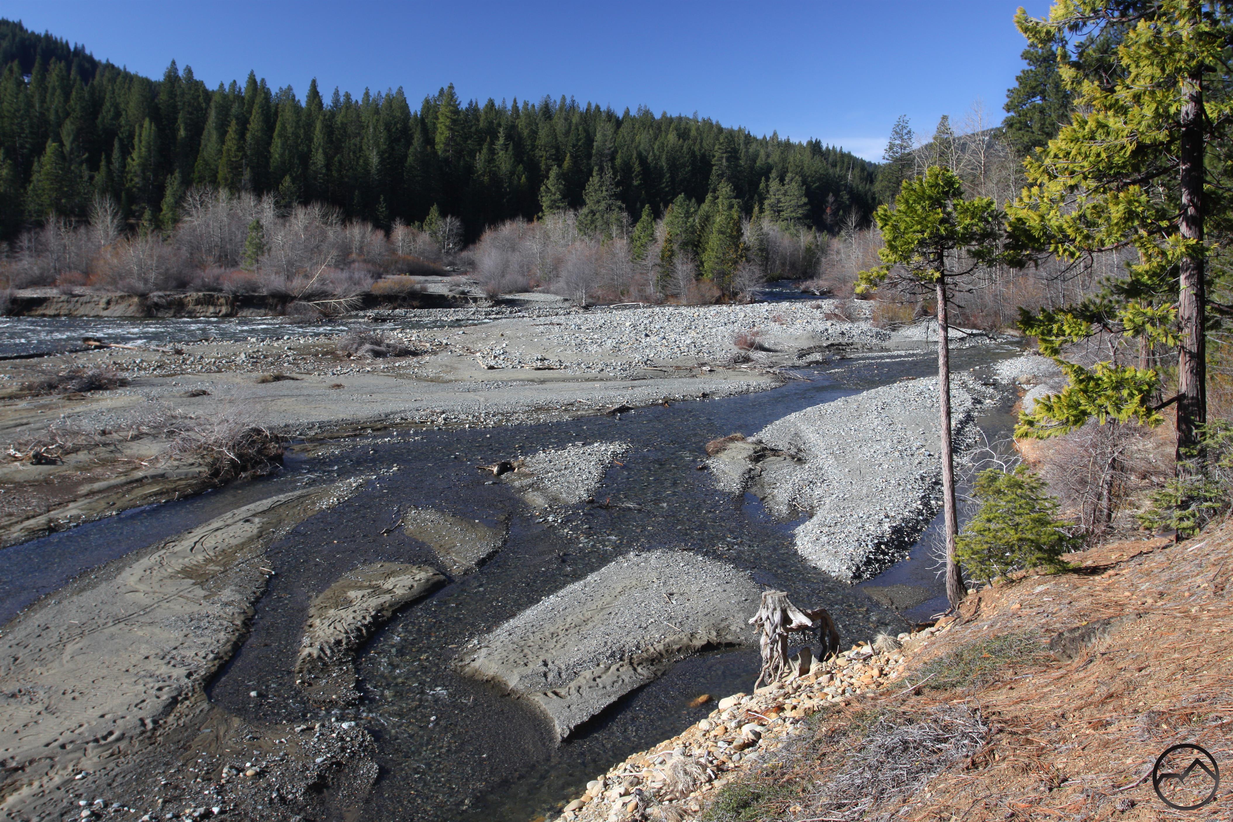
Riparian vegetation is abundant once the trail nears the river. Stay alert for signs indicating the tail’s route. There are well-established use trails that continue to the west, paralleling the Sacramento River. These make for pleasant hiking in their own right. Rather than continuing to the west, the Lake Siskiyou Trail turns to the south and crosses a series of small overflow creeks. The trail eventually deposits hikers on the banks of the river. Metal bridges set on top of thick wire baskets filled with river rock provide an easy way across the rushing waters. Note that these bridges are removed from November through April. During the winter it may be possible to cross the river anyway but once the spring runoff comes the Sacramento is a raging torrent and should not be crossed. On the far side of the river the trail continues through the river’s wash which consists of rocky ground littered with river rock. This side of the lake is popular with picnickers for obvious scenic reasons. The highlight is the view to the west, where Mount Eddy looms 6,000 feet overhead. In truth, this is one of the wilder, more natural areas of the entire trail and the presence of the river adds a great deal of ambience. The sandy path proceeds for 0.15 miles to the far side of the wash where a second channel of the Sacramento is revealed. The river actually split into two large channels further upstream. Another set of seasonal bridges crosses the river. The trail then makes one short switchback up the embankment and then begins the long eastward journey along the lake’s south shore.

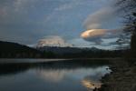
The mountain comes into view from the south shore.
Once on the south shore, the wide trail passes through mixed woods just above the lake. It soon crosses a seasonal creek on a well-built, heavy wooden bridge. The creek begins a few miles to the west, high up on Scott Camp Ridge. Beyond the bridge the trail continues to parallel the edge of the lake. It eventually arrives at a trail junction marked by a gate. Hiker portals permit passage through the gate while preventing vehicles from getting through. The official route of the Lake Siskiyou Trail turns right at the junction and heads up hill on a dirt road. The trail then veers off the road and passes through chaparral until it emerges in the southwest corner of a large parking lot at the Lake Siskiyou Boat Ramp. This section of the trail has no views, is hot and has minimal shade. Instead of going this way, continue along the trail by the lake. It passes occasional picnic tables with views across the lake of Mount Shasta emerging from behind Rainbow Ridge. The trail soon arrives at the actual boat ramp on the lake. There are good, clean bathrooms on the far side of the boat ramp, a departure from the pit toilets that have been common at parking areas up to this point. Whichever option one takes to get to the boat ramp area, there is minimal signage indicating where to go from here. The best course is to head toward the little store at the parking lot. From there follow the road a few yards and look for a sign indicating the Lake Siskiyou Trail, which heads off the road to the east. Hike through the tree along the rock-lined trail. At the telephone pole turn right and walk the rest of the way to the road. Be sure not to continue straight at the telephone pole. Though the trail is well-established, it only leads into the campground.

Summer fun at Lake Siskiyou.
Once at the road, the trail basically cuts through the heart of the Lake Siskiyou Resort. During the summer months there is an incredible amount of activity in this bustling vacation community. Staying along the road, the path proceeds east. Along the way it passes campgrounds, a laundry, a playground, the general store and the Lake Sis restaurant. Beyond the general store area the trail crosses a road and the activity begins to fade significantly. As the woods begin to thicken, a sign indicates a side trail branching off to the east toward the lake. Though this trail is not part of the loop around the lake, for those with the time, it is a pleasant option that leads along Scott Camp Creek arm of the lake. Occasional use trails lead down to rope swings and water access. The path eventually arrives at the edge of the main body of the lake and turn back to the west, eventually leading to the resort’s beach. Here there is an iconic view of Mount Shasta towering majestically over Lake Siskiyou (and everything else, for that matter). The beach has a snack shack and all sort of aquatic recreation available.

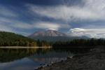
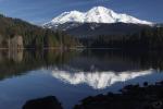
Mount Eddy reflects in Lake Siskiyou.
Resuming the loop around the lake, the trail departs the resort on a wide dirt road. It hugs the contours of the water as it first heads west along Scott Camp Creek, crosses the creek and then returns to the east, this time on the south side of the creek. It is possible to climb down to the water and there are some nice pools in the creek that make great spots to relax. The trail continues past where the creek’s waters meet Lake Siskiyou. The route then turns to the right, now following the impounded waters of Castle Lake Creek, which emerges from, not surprisingly, Castle Lake. The trail follows this arm of the lake to the creek’s inlet and makes another crossing. Once on the east side of the creek, the trail heads north a short distance to another trail junction. Like the north shore, the south shore of Lake Siskiyou has a primary trail and an alternate route. The main path stays away from the lake and cuts straight through the woods to the trail’s final parking area. A much more scenic option is to take the single-track alternate route, which stays close to the water and has views. The perspective is particularly good for Mount Eddy. The immense bulk of the mountain are impressive from here.
This path eventually ends at an area with picnic tables on the south shore. From this point hikers can appreciate one of the most spectacular views of Mount Shasta to be found anywhere. The great mountain towers high overhead and reflects in the lake’s clear waters. It is a tremendous climax to the trip around the lake. This spot is also easily accessed from the aforementioned parking area and is a great easy-to-get-to place to go to when trying to take pictures of Mount Shasta. When one is finally able to pull away from the incredible view, head up the wide path toward the parking area. A signed junction marks the return to the main branch of the Lake Siskiyou Trail. Turn left and continue through the woods to the Box Canyon Dam. Be sure to cross the dam on the east side to catch glimpses of the awesome canyon of the Sacramento River. On the far side of the dam is the parking lot from which one set out.
South Shore Gallery


The main trail is marked in red. Alternate trails, which are generally prettier, are marked in green.
Directions
From the town of Mt. Shasta, head west on W. Lake, crossing over I-5. At the stop sign, turn left onto Old Stage Road. After 0.25 miles, veer right onto WA Barr Road. Continue south, turning right into the parking lot just before crossing over the dam that impounds the Sacramento River and forms Lake Siskiyou.

Pingback: Lake Siskiyou | Jan's Jaunts and Jabberings
Pingback: Off Season Trails: Two Hikes On The Lake Siskiyou Trail | Hike Mt. Shasta
Pingback: Lake Siskiyou Trail (South Shore Loop) | Mount Shasta | Hikespeak.com
These are gorgeous photos & a great run-down of the details about the trail… I love it… Keep up the great work.
Pingback: Shasta Spans: 5 Interesting Footbridges | Hike Mt. Shasta
Pingback: Lake Siskiyou Trail Washes Out | Hike Mt. Shasta
Pingback: Lake Siskiyou Trail Washed Out | Hike Mt. Shasta
Pingback: Weekend nature retreat: Mount Shasta | A blog by Sunset
Pingback: Sacramento River Still Altering Landscape | Hike Mt. Shasta
Pingback: Sacramento River Still Altering Landscape Addendum | Hike Mt. Shasta
Pingback: Sacramento River Still Altering Landscape: A Different Perspective | Hike Mt. Shasta
Can you take bikes on this trail?
Pingback: Of Dams and Raging Rivers | Hike Mt. Shasta
Pingback: Of Dams and Raging Rivers | Hike Mt. Shasta
Pingback: The Lost Creeks Of Lake Siskiyou | Hike Mt. Shasta
Pingback: The Sacramento River Is Up To Its Old Tricks Again | Hike Mt. Shasta
Pingback: Sacramento River Inlet Follow Up | Hike Mt. Shasta
Pingback: More Damage To Lake Siskiyou Trail | Hike Mt. Shasta
Would we be able to ride our bikes with a bike trailer and toddler?
Yes, though the loop is incomplete right now, since the temporary bridges are not up yet (to my knowledge).
Pingback: Trinity Divide Trails Open! | Hike Mt. Shasta
Pingback: 5 Mount Shasta Area Trails We Need To Build | Hike Mt. Shasta
Pingback: Weekend nature retreat: Mount Shasta
Pingback: Clearing The Mount Shasta Spindle | Hike Mt. Shasta
Pingback: Lake Siskiyou Inlet Update | Hike Mt. Shasta
Pingback: Lake Siskiyou Bridges Installed | Hike Mt. Shasta
Pingback: California Coast Road Trip Guide – Live To Sustain
Pingback: Fall Color Is Very Erratic This Year | Hike Mt. Shasta
Pingback: Lake Siskiyou Autumn Idyll | Hike Mt. Shasta
Pingback: Lake Siskiyou | Mt Shasta ⋆ California Perspective.com
Just FYI this write up says the bridges across Sacramento River running into the lake are off until April. Well… It’s May 22, 2019 and they are still off Can’t make the loop at this date this year.
Pingback: Shasta Spans: Five MORE Interesting Foot Bridges | Hike Mt. Shasta
Pingback: Checking In On The Sacramento River Inlet | Hike Mt. Shasta