
At A Glance
A gorgeous hike through high desert and oasis-like meadows with great views of wildlife, surprising Orr Lake, the Cascade crest and majestic Mount Shasta.
Total Distance: 3.7 miles.
Elevation Gain: Level
Season: All year
Desert Oasis
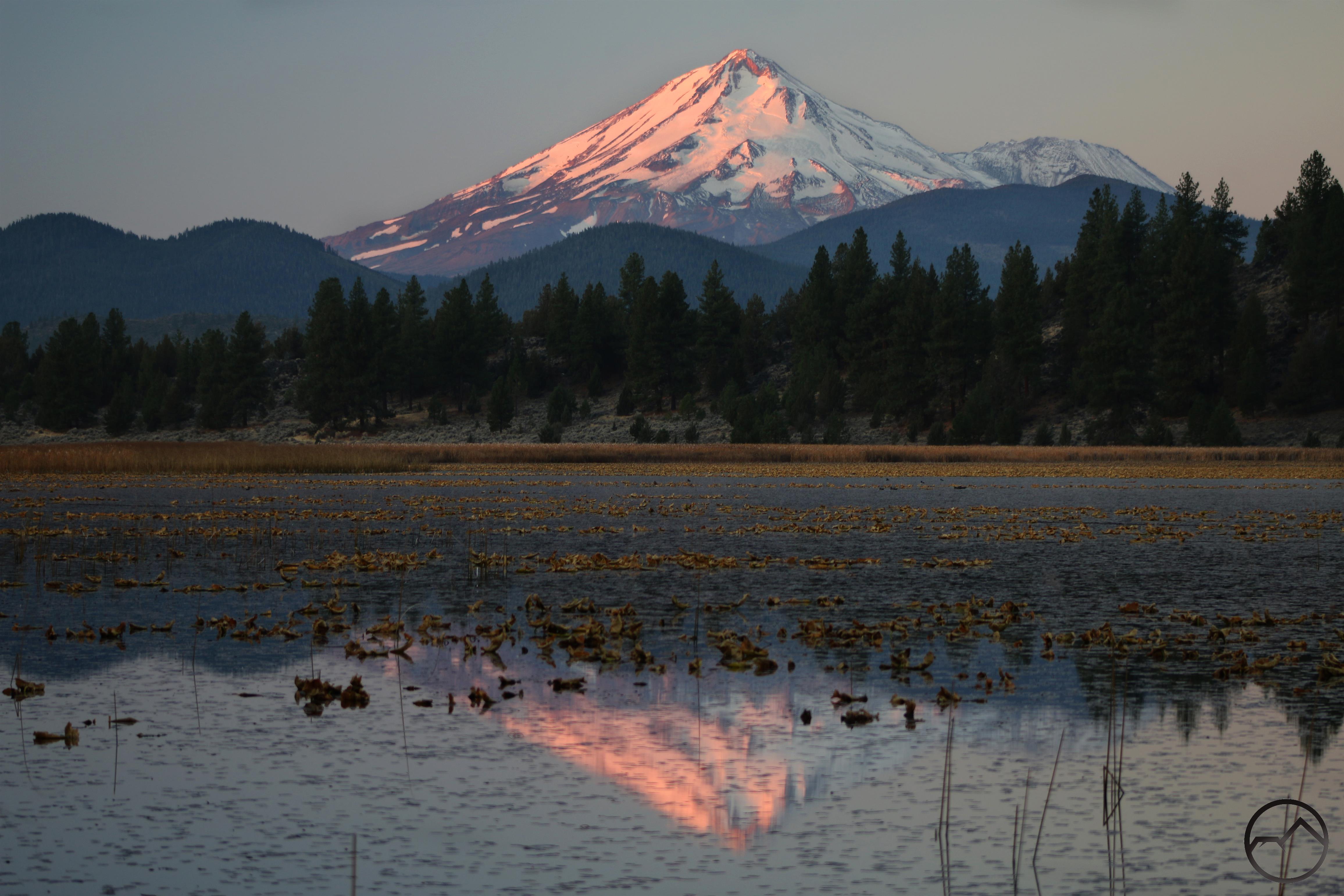
Sunrise at Orr Lake.
Tucked between a steep ridge and a large volcanic plug, remote Orr Lake is wonderfully scenic corner of the Mount Shasta region. Flanked by a pleasant mix of pine forest and high desert landscape filled with sagebrush and juniper, the lake is a surprising oasis amid a thirsty land that lies in the rainshadow of mighty Mount Shasta. Generally unknown and overlooked, this land is lives at two extremes. On one hand, this area is essentially a desert. Little precipitation falls out here, most of the moisture having been wrung from the clouds by the great volcano. Yet, in the midst of the arid earth the life-giving waters of nearby Butte Creek has created a lush riparian area blessed with meadows amidst the desert. Between these two poles lies Orr Lake. It is situated in a notch created by a ridge running south from nearby Mount Hebron and the western flank of dome shaped Orr Mountain. The notch seems to feed off of the water supplied by adjacent Butte Creek, possibly when the creek overflows during the spring thaw. Since there is no constant flow from a creek flushing the plant life out of the lake it has a significant lilypad presence. Despite this the lake is an excellent destination for fishermen. More importantly, the lake is a significant component to an area that, while different from most areas around Mount Shasta, is remarkably scenic.
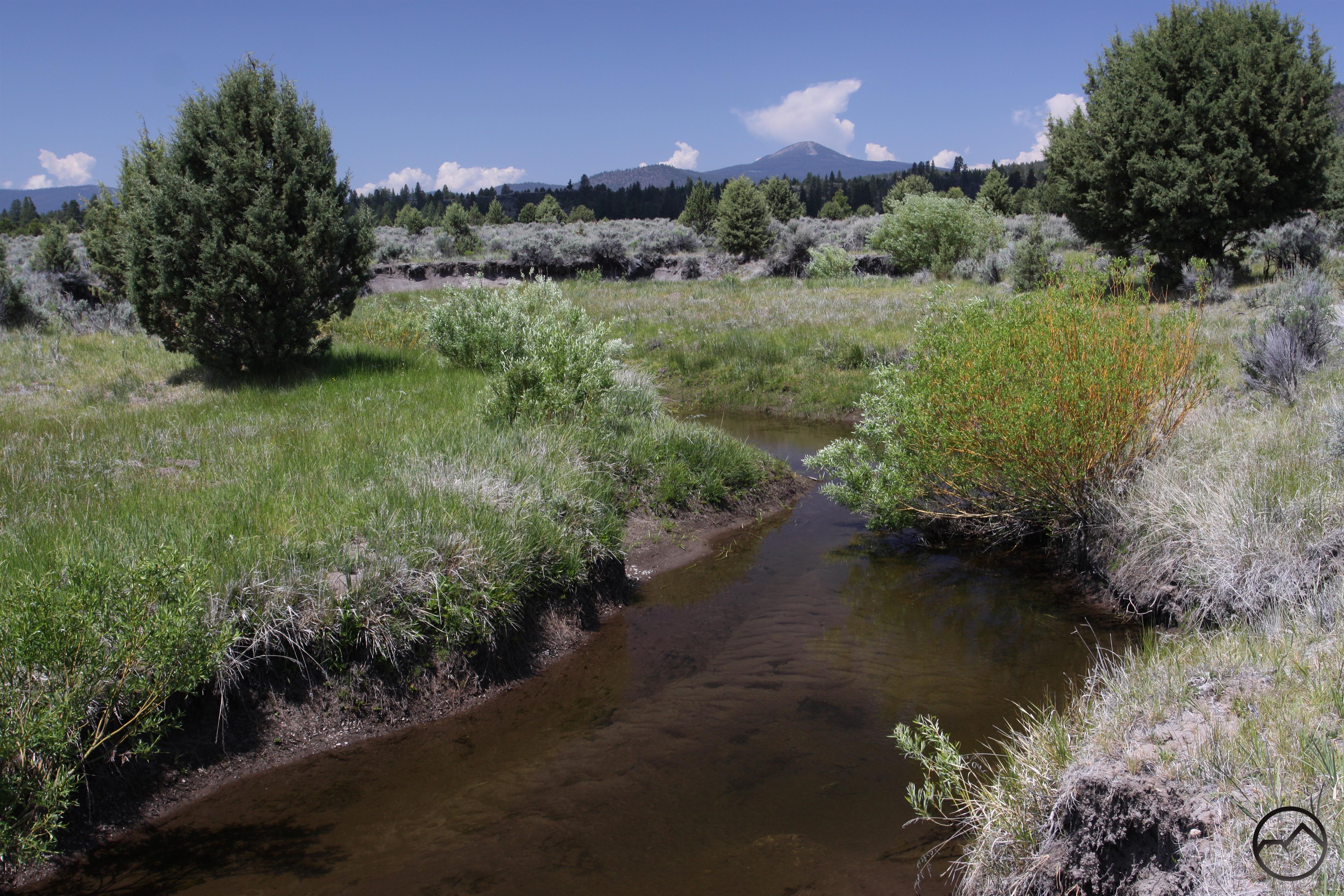
The Goosenest rises beyond a lazily meandering Butte Creek.
For whatever reason, the area to the north of Mount Shasta is not a well-known destination for hikers. While it is not particularly close to any of the area’s population centers, it is still easily accessible and close enough to make a convenient trip from Weed or Mount Shasta, even for a few hours. The Orr Lake Trail in particular makes a great outing for both serious hikers and families looking to enjoy some easy hiking with great scenery and abundant wildlife. Skirting the edge of the lake, the trail also extends further to the south and provides easy access to Butte Creek. This creek rises in the high, remote mountains immediately east of Mount Shasta and flows north through some broad valleys until it reaches large Butte Valley. Butte Creek is endorheic; it does not connect to any other river or creek and its waters never reach the sea. Instead it dissipates in large, shallow, marshy Meiss Lake and evaporates (though nowadays the creek is mostly used for agriculture well before it gets to the lake). Whatever its fate, Butte Creek is a very scenic destination and boasts awesome views from its banks. It is a worthy destination for a great hike.
The Trail
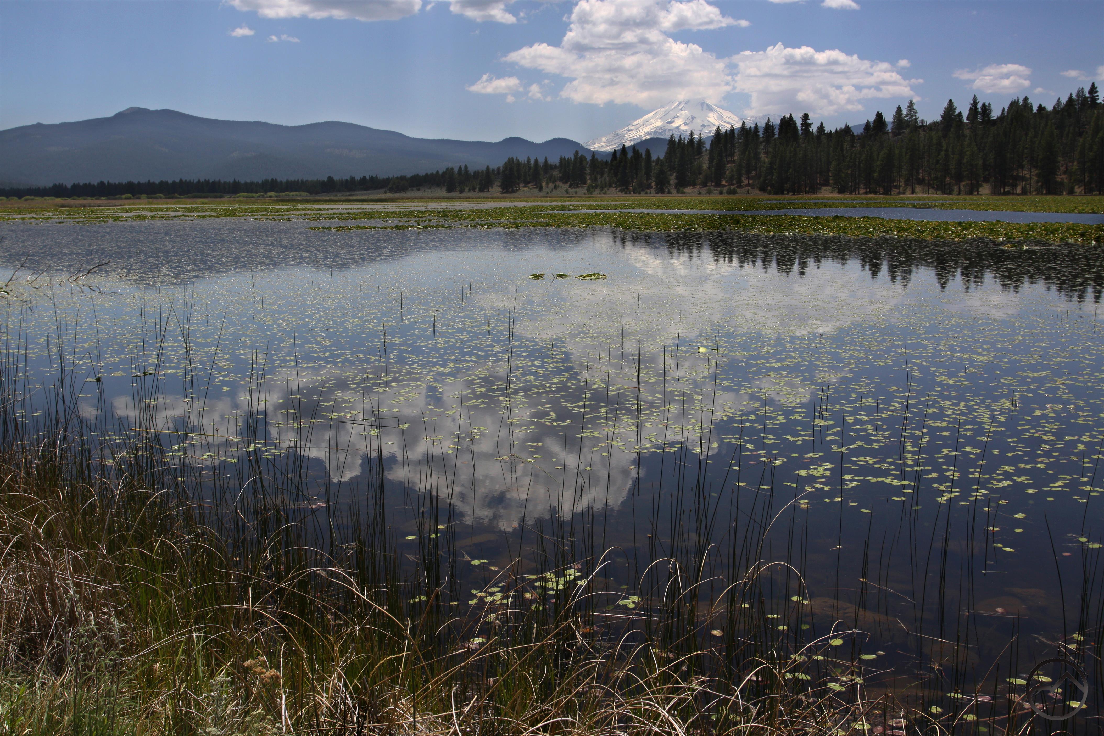
Clouds building over Mount Shasta reflect in Orr Lake.
From the day use parking area on the edge of the Orr Lake campground, follow the dirt road down to the small boat launch. A small floating dock is adjacent to the launch and there are great views of the lake and Mount Shasta in the distance from it. When it is time to begin the hike, head north on the wide path, skirting the edge of the lake. The views of Mount Shasta continue for a little while before the gradually changing obscures the mountain behind the ridge on the west side of the lake. After following the lake for 0.25 miles the trail passes another floating dock. These are intended to be platforms from which fishermen can reach out to the deeper sections of the lake. Beyond the dock the trail begins to arc to the west, passing a third dock before the path passes through Orr Lake group campground, about 0.5 miles from the trailhead. The views of the lake and the mountains to the south, notably the rounded summits of Haight Mountain and West Haight Mountain are great. Past the campground the trail begins to turn to the south, passing two more floating docks as it does. Just beyond the last dock there is a pair of rock columns supporting a tall log fence blocking the trail. This is 0.65 miles from the trailhead. The path beyond the fence is closed from spring through July 15th in order to protect nesting fowl. If within that time frame, return to the trailhead, enjoying the increasingly good views of Mount Shasta during the walk back.
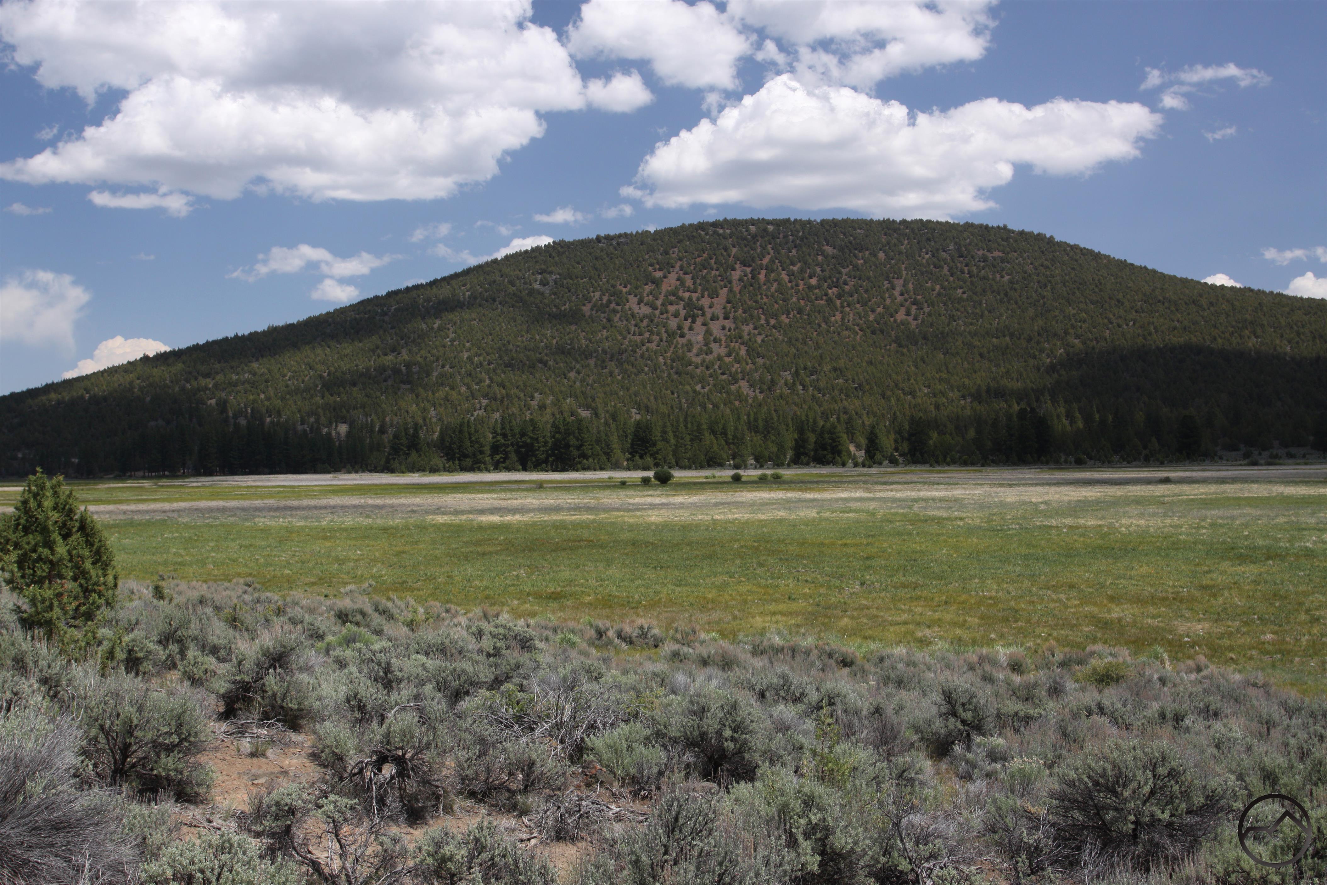
Orr Mountain looms on the far side of the Orr Lake meadows.
If it is within the permissible time of the year, hop over the fence and continue on the trail, which is now an old road. It should be noted that it does not seem possible for horses to get around the fence. Once on the old road it is obvious that vehicular traffic has not been on it for a long time. It now appears like to parallel single track trails. This section of the trail has a fair amount of shade and is hemmed in by the steep ridge on the right and the lake immediately to the left. A band of trees filters the view of the lake for 0.5 miles before the trail finally emerges from the forest cover. There are high odds of seeing numerous types of birds along this section of the hike. Birds (including pelicans and great horned owls) in particular are abundant around here and are easily observed. Though nothing was hidden from sight while in the forest, the views improve significantly once the trail is in the open. By this point the trail has moved beyond the southern shore of Orr Lake and the area to the left of the trail is a vast marshy meadow. On the far side, towering high above the campground area, rises the juniper cloaked dome of Orr Mountain. Although it is not visible from the trail, there is a Forest Service lookout tower on the summit. While admiring the views, continue south on the level path, avoiding randomly placed sage brush growing out of the old roadway.
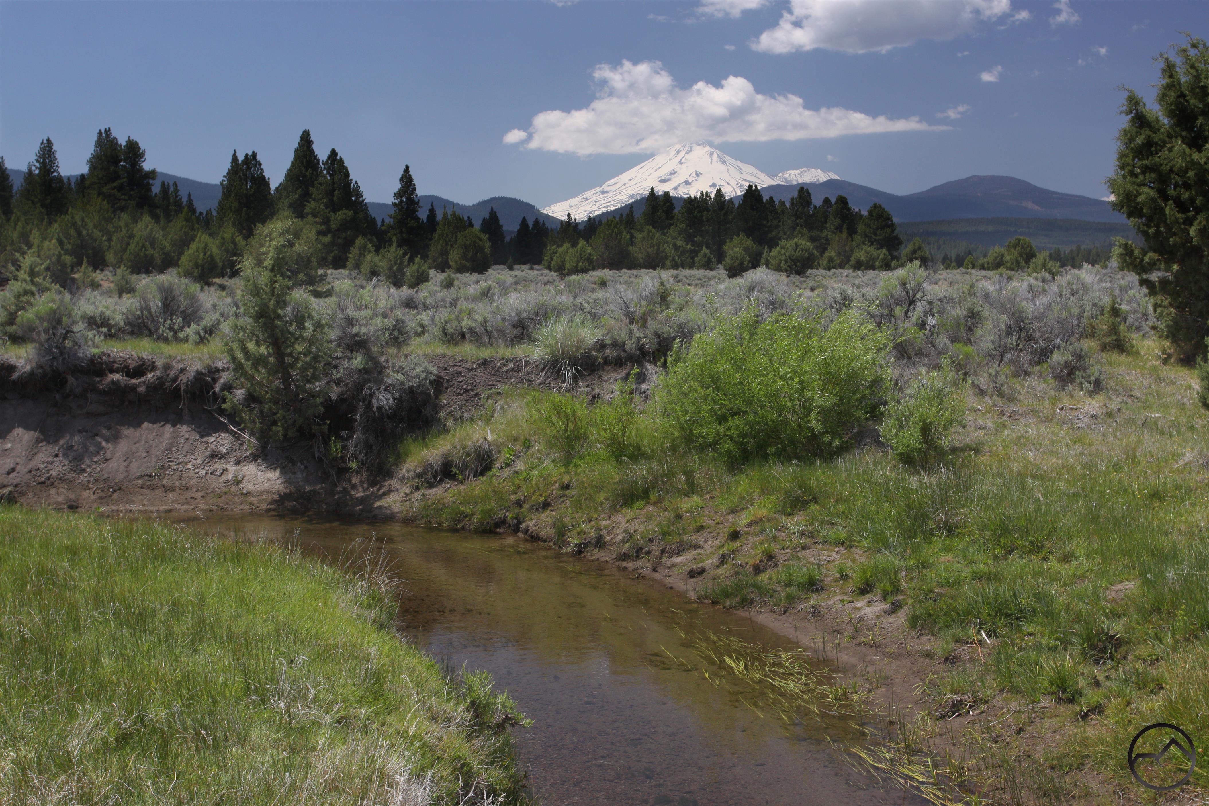
Mount Shasta towers above Butte Creek.
Finally, after 0.9 miles from the fence blocking the trail the path finally turns to the west, rounding the end of the long ridge that forms the western edge of Orr Lake’s basin. As the trail changes its orientation Mount Shasta finally comes back into view, towering above the rounded hump of the Whaleback, one of the tallest peaks in the Mount Shasta area. At this point Butte Creek flows just a few yards south of the trail and it is an easy matter to bushwhack out to it and worth the effort since the meadow is much more extensive here than it is a little further upstream. However, pressing on just a little further leads to some better views of Mount Shasta and the opportunity to enjoy some oxbows on Butte Creek. To reach this point, follow the trail a little further to the west. While going down a slight grade veer left at a junction onto a signed forest “road”. Immediately after the junction the old road crosses a season creek which will usually be dry. Though the road continues for a long way after the crossing, it is best to head south right after the crossing for a couple dozen yards, picking an easy route through the sagebrush. Doing this will lead to some lovely meadows along the banks of Butte Creek as it twists lazily around some very convoluted oxbows. Some of the oxbow necks are less than 10 feet wide and Butte Creek almost makes complete circles. The views from these meadows are magnificent. The towering cinder cone summit of the Goosenest rises to the west, while Orr Mountain lines the eastern horizon. However, it is the towering icy cone of Mount Shasta looming to the south that inevitably draws attention. It is a crowning sight to an already beautiful setting. Return to the trailhead by retracing the route.

Directions
From the beginning of Highway 97 in central Weed, head east on Highway 97 for 28.5 miles. Turn right onto Tennant Road, which is signed for Tennant and Bray. Follow this paved road for 5.1 miles then turn left onto Old State Highway, which is a well maintained gravel road. Continue down this road for 2.2 miles. Turn left onto Orr Mountain Lookout Road, which is signed for Orr Lake. Cross over the railroad tracks and then cross a bridge over Butte Creek. Proceed for another 1.75 miles on the rougher but still passable dirt road, staying left at the fork shortly after crossing Butte Creek. Park at the day use area at the Orr Lake campground.

Pingback: 2018 Spring Hiking Round Up | Hike Mt. Shasta
Pingback: Alpenglow And Aspens: A Morning On The East Side | Hike Mt. Shasta
Quietly approach and look for River Otters in Butte Creek.
Pingback: 2021 Mount Shasta Spring Hiking Round Up | Hike Mt. Shasta