
At A Glance
A beautiful loop ascending one meadow clad canyon and descending another, adjacent canyon with more meadows and a raucous creek. The highlight of the loop is a pair of superb lakes nestled in giant granite cirques at the head of each canyon.
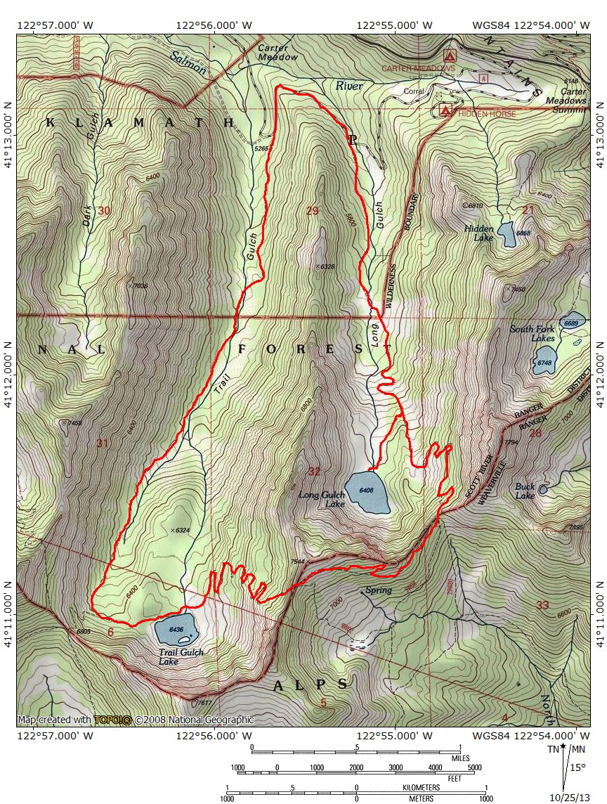
Total Distance: 9.2 miles
Elevation Gain: 2,400 feet
Season: Summer, Fall
Gorgeous Gulches

Great view above Long Gulch Lake.
The loop that that connects Trail Gulch and Long Gulch Lakes is one of the best day hiking options in the Trinity Alps. Boasting a pair of fantastic lakes, easily among the best of the numerous lakes that are scattered around the perimeter of the Trinity Alps Wilderness, the route offers awesome scenery for a fairly moderate amount of effort. That such a great hiking is found in the remote northeast corner of the Trinities should not come as much of a surprise. The area is blessed with no less than 8 gorgeous dayhiking options. Considering that, for the most part, the Trinity Alps are a backpacker’s range because most of the best destinations are too deep in the wilderness to be accessed with a single day of hiking, the abundance of excellent single-day trip options in this region is a great resource. Of the hikes in this area, the Gulch Lakes Loop is possibly the best, with completion only coming from the East Boulder Lake Loop. While that hike may have better panoramic views, the Gulch Lakes Loop has better scenery and that on a larger scale. The canyons traveled by the loop are deep with sheer, spire-topped cliffs, racing creeks and lush meadows. The pair of lakes, strikingly similar in appearance, are among the best in the Trinity Alps. They are deep and backed by incredible granite cliffs rising 1,200 feet above the water. Amazingly, the trail is pretty moderate, considering that one must hike to the rim of the one of the cirques in order to traverse a ridge and drop down into the adjacent canyon. Combining the surprising ease of the trail with the incredible scenery and hikers are left with one of the best hikes in the Trinity Alps.
One cautionary note must be mentioned. This area is notorious when it comes to how poorly it is mapped. The most infamous of the mapping issues is the switching of the names of the canyons and the lakes they contain. On the USGS map used by Hikemtshasta.com, the names for the canyons and lakes have been switched. That which is marked as Trail Gulch and Trail Gulch Lake is in fact Long Gulch and Long Gulch Lake. The reverse is true for what the map identifies as Long Gulch. The names were corrected for the Trinity Alps trail map produced by the Forest Service and these changes, which are restorations of the original names, are reflected in the trail signs that appear along the route. Consequently, the description on this site will follow the original names for the canyons and lakes as they appear on the trail signage. Understand that what appears on the map posted to this page must be understood to be reversed from the description. As if this was not enough, the map contains significant differences with the reality of the trail’s routing. This is particularly true of the omission of many significant switchbacks. The map included on this page has also attempted to correct these mistakes. Fortunately, none of this adds any difficulty in figuring out the route once on the trail. The path is well-signed as easy to navigate.
The Trail
Since the trail is a loop, it can be done in either direction. However, beginning with an ascent of Trail Gulch and first coming to Trail Gulch Lake (remember, this is reversed from what appears on the map) is the more pleasant option. Hiking this direction means that one is facing good scenery earlier in the trip, the first lake is reached a bit sooner and the climb up to the rim of the canyon is a bit more moderate. It also saves the great view of Long Gulch Lake from the rim above the lake, the highlight of the trip, for a little over halfway, adding the climax closer to the end of the hike. This description will follow this direction.

Autumn view of the large meadow in Trail Gulch.
The trailhead for the hike up to Trail Gulch Lake begins right next to Trail Gulch Creek. Unfortunately the path instantly veers away from the creek and begins to climb moderately to the south. The first part of the route is obviously an old jeep road. Fortunately the trail consists of good single-track worn into the old roadbed. Though at times the creek is audible the trail never really comes within range of it. Forest canopy is what one will see for the most part along the trail. Finally, after about 0.75 the old road emerges out of the trees and enters an beautiful little meadow that is crowned by a rocky spire that lines the crest of the ridge on the west side of the canyon. At the meadow the route crosses the boundary into the Trinity Alps Wilderness and the old road bed ends, becoming true single-track for the first time. At the far end of the meadow the trail crosses Trail Gulch Creek, entering an even larger meadow that climbs up the east side of the canyon. If there is one drawback to the trails in the northeast corner of the Trinity Alps, it is the occasional presence of cows grazing. Ranchers in the Scott Valley still use this area as summer range. Rather than seeing them as a detraction, appreciate the opportunity to observe open range, something that is dying out in the West.

Crags lining the rim of Trail Gulch.
Beyond the large meadow the trail begins to climb and passes through a few more small patches of meadow. Views of the craggy ridge that forms the west side of the canyon improve and make the somewhat steeper trail more enjoyable. Willows line the trail to the west, marking the path of Trail Gulch Creek. Though the water can be heard, it once again cannot be seen from the trail. In fact, other than at the outlet of the lake the one crossing of the creek constitutes the sole encounter with Trail Gulch Creek along the entire loop. Thankfully this is not true for lovely Long Gulch Creek, which accompanies the trail on the return to the trailhead. Soon the trail encounters the first of many sets of switchbacks that make the loop easier. This set of switchbacks climb a large rocky slope, passing large boulders as it ascends to the top of a bench. Views to the north, looking down the length of Trail Gulch are fairly good and add a little more pleasure to the climb. Once on the bench the trail proceeds a little further before it finally arrives at a signed trail junction.

Trail Gulch Lake.
To reach Trail Gulch Lake, stay to the right at the junction. The fairly level path continues south for about 0.4 miles to the lake. Granite boulders are strewn about the area and the trail winds its way among them. Finally the path emerges at the edge of the 14 acre lake. A nearly vertical granite cliff towers high above the south end of the lake, making an incredibly beautiful sight from the edge of the lake. The cliffs above the west side of the lake are nearly as vertical, but not quite as craggy. Still, the entire scene is wonderfully serene and beckons hikers to relax on the grassy shore for a while. Note the gully leading up the cliffs on the west side of the lake. The adventurous could use this gully as a shortcut to cross over into Long Gulch. From there, a short cross country jaunt would reconnect to the trail on its descent down to Long Gulch Lake. To return to the trail for the full loop, simply retrace one’s steps back to the junction.

Looking down on Trail Gulch Lake from the canyon rim.
Once on the main trail, the path continues to the south. It soon arrives in a large, rocky clearing where the walls of the canyon begin to close in. Here the trail begins another set of switchbacks. The path makes a wide arc back to the north, just skirting the edge of the clearing before it reenters the forest cover, passing through old growth stands of Shasta red fir. A few more switchbacks continue up the side of the canyon wall, though they still remain under the canopy of the trees. Eventually the path straightens out and traverses across the top of the aforementioned rocky open area. Views of the cliffs above Trail Gulch Lake are good though the lake itself is obscured. One more set of switchbacks climb the rest of the elevation necessary to reach the rim of the canyon. From here there are fantastic views of Trail Gulch Lake 600 feet below as well as down the length of Trail Gulch toward the granite crags of the Russian Wilderness. By climbing to the top of the canyon rim, hikers have now passed from the Salmon River watershed into that of the Trinity River and hence, into Trinity County.

The view up Coffee Creek’s north fork, toward Billys Peak.
Once on the ridge, the trail descends a short distance to the south before it arrives at a four-way junction. The first trail splitting off to the left follows the course of the North Fork of Coffee Creek. This is signed as the trail to Schlomberg Site, where there are the remains of a cabin. The second trail to split off to the left drops down to Steveale Meadow and the South Fork of Coffee Creek (which, for what it is worth, is north of the main fork of Coffee Creek and west of the North Fork). To continue on the loop, stay all the way to the right. The narrow path maintains a fairly level grade here, initially passing through a few grassy patches with views to the east of peak 7,794, the triple-divide peak that towers high above the South Fork Lakes. Soon the trail enters a densely wooded area. There is one brief view to the southeast, where one can observe the rarely seen north face of rocky Billys Peak before being swallowed up into the forest cover, where the trail will remain until it arrives at the rim above Long Gulch Lake. The path is fairly level along this stretch though it does have set of switchbacks about halfway between the lakes. Finally, when the trail does arrive at the rim above Long Gulch it passes beyond the trees and there are great views to the south into the heart of the Trinity Alps and back to the southwest, down the canyon of the North Fork of Coffee Creek and beyond, to Billys Peak once again. Few trails in the Trinity Alps offer an opportunity to appreciate this underrated mountain.

Looking down on Long Gulch Lake from the canyon rim.
Once on the rim above Long Gulch, there is one of the finest vistas of the trail. The granite cliffs of Long Gulch Lake’s cirque soar high above the meadow lined lake that lies nearly 1,000 feet below. In a separate basin on the far side of the cirque lies the lone tower of Deadman’s Peak. It should be noted that different scales of the USGS map identifies two different peak’s as Deadman’s Peak. The scale used for this page’s trail map marks the peak above the basin to the west of Long Gulch Lake (which is, of course also mislabeled) as the peak. The next USGS map for the next scale up identifies the point directly above Long Gulch Lake as Deadman’s Peak. It is likely that the map with the closest scale is correct and that the peak one basin away from Long Gulch Lake is actually Deadman’s Peak. Not only is it the taller of the two, it is easily recognized as a tall peak. This is in contrast to the point above the lake, which is a bit of a mild hump. Of course, given the great beauty of the area, it is a very beautiful mild hump. Returning to the trail, from the rim, the trail begins to make a descent into Long Gulch. It soon arrives at a switchback. Continue past the trail and veer a bit to the south for about 50 yards above a large boulder field. This point has the best views of Long Gulch Lake and the head of Long Gulch.

Long Gulch Lake.
Having had a fill of great vistas, resume the descent on the trail, which proceeds to follow a series of switchbacks. Views are at times good but there is also a fair amount of forest cover. About halfway down, note the unusual crater set amidst the rocks on the right side of the trail. Finally, having dropped nearly 1,000 feet, hikers are deposited at beautiful, 10 acre Long Gulch Lake. Willow thickets black access to the lake where the trail finally levels off. Take an obvious side trail to the left to clear the thicket and enter a lovely meadow on the edge of the lake that is dotted with numerous granite boulders. Note the large rocky island in the lake. This makes a great swimming destination on hot summer days. Back on the main trail, the path stays just north of the lakeshore. It soon reaches a small patch of meadow that lines Long Gulch Creek. The trail becomes obscure here. Simply go due west across the meadow and creek and look for the trail to resume at the line of trees at the far side. Once the trail has been found, proceed to the west. There is easy access to the lake along here and great views of the canyon wall on the east side of the lake.

Avalanche damage in Long Gulch.
Beyond the lake, the route descends a broad, boulder filled gully as it heads west. Stay right at a signed junction. Beyond this point the trail turns to the north and begins its descent of Long Gulch. The grade is very moderate and the path pleasant. Though there is some forest cover in parts, there is a fair amount of open country with good views of Long Gulch’s cliffs and Long Gulch Creek. Small meadows pop up occasionally, adding some variety as well. Be sure to note the destruction wrought by large avalanches along the trail. Trees large and small were torn apart and tossed down to the bottom of the canyon. About 1 mile from the junction the trail edges close to the main fork of Long Gulch Creek. Another 0.75 miles further the route crosses over the creek. At this point the trail strays away from the creek and continues another 0.8 miles to the Long Gulch Trailhead. To complete the loop turn to the right and walk along the road for yet another 0.8 miles back to the Trail Gulch Trailhead. There is a single-track trail that parallels the road and joining the two trails but it is difficult to find. It is easier to simply stay on the road.
Directions
From Mount Shasta City, drive north on Interstate 5 for 12 miles. Take the Edgewood/Gazelle exit, turn left under the freeway then immediately turn right onto Old Highway 99. Proceed north for 7 miles, entering the small community of Gazelle. Turn left onto the Gazelle-Callahan Road. Drive this scenic road for 24.8 miles, continuing another 2.1 miles after it merges with Highway 3. At the north end of the small village of Callahan, turn left onto the Callahan-Cecilville Road, which is also named Forest Highway 93. Continue for 12.3 miles on this interesting road to the signed turnoff for Carter Meadows Campground. Do not confuse this with the Carter Meadows Summit Trailhead, which will be at 11.8 miles. Continue 0.5 miles past the trailhead to the turnoff for the campground. Once on the very well graded dirt road, proceed 2 miles to the Trail Gulch Lake Trailhead. The trailhead is well signed and located just beyond the crossing of Trail Gulch Creek.

Pingback: The Trinity Alps’ Carter Meadows Area: An Abundance Of Riches | Hike Mt. Shasta
Pingback: It’s All Up Hill From Here | Trevor Sowder Photography
We hiked this trail on 6/24/17, and were stopped from continuing the loop by snow on the north facing slopes leading down into Long Gulch. However, it was worth the trip to the high point above Long Gulch Lake just for the views alone. Trail Gulch Lake was lovely also. I imagine it might take til late July for the snow to melt off.
It really is crazy how much the snow has closed stuff off…and we didn’t get nearly as much as the Sierra did!
Which direction were you hiking? Was it the stretch between the lakes that was impassable? We are headed up on July 28th.
Thanks
Pingback: Trail Gulch Loop (Trinity Alps Wilderness) 03-Jun-2015 | Boots on the Trail
Pingback: Looking For Relief From Smoke? Trinity Alps Might Offer A Chance | Hike Mt. Shasta
Pingback: Trail Gulch Lake (Trinity Alps Wilderness, CA) | Live and Let Hike