
At A Glance
Climbing steeply up Billys Peak Lookout to the site of an abandoned lookout tower, the Billys Peak Trail offers great views of the Trinity River region. Only the last third of the hike is particularly scenic and the views come at a price.
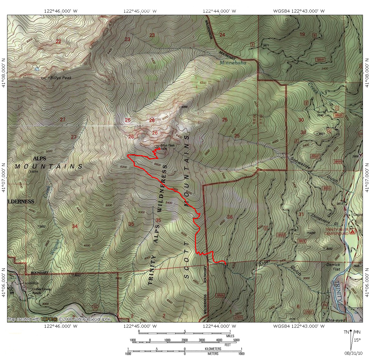
Total Length: 6 miles
Elevation Gain: 2,800 feet
Season: Summer, Fall
Billys’ Unnamed Brother

Mount Shasta and Trinity River from Billys Peak Lookout.
Ironically, the Billys Peak Trail does not climb Billys Peak. Instead, it surmounts the large granite pinnacle known as Billys Peak Lookout. The Lookout is separated from the Billys Peak by a saddle that dips over 1,000 feet below the two summits. The trail was originally built to provide access to the Forest Service lookout that once stood on the summit. Though gone, the lookout still provides the name to the otherwise nameless peak. The trail climbs steeply up the southern flank of Billys Peak Lookout, gaining just under 3,000 feet in 3 miles. Adding to the difficulty of the grade, the trail has not been maintained in quite a while and though the route is obvious, it is severely overgrown. This is particularly true in the higher portions of the trail where the route is almost entirely obscured. Only the rocky construction of the route gives indication of where to go in these sections. Further evidence of the lack of maintenance is the nearly 4 dozen snags that have fallen over the trail in the first mile. Despite these obstacles, the Billys Peak Trail is an excellent option for those who want climb directly into the Trinity Alps high country from right off of a highway.

Billys Peak Lookout and Billys Peak above the Trinity River.
Billys Peak Lookout is a massive granite pyramid, one of the easternmost outliers of the Trinity Alps. Only the craggy, unnamed peaks surrounding Big Bear Lake are further east. Consequently, the peak is one of the most easily viewed summits of the Trinities, prominently visible from Highway 3 in the Trinity River Canyon and from numerous locations throughout the Trinity Divide. However, ease of viewing and proximity to a highway does not translate into frequent ascents of the mountain. On the contrary, Billys Peak Lookout is seldom visited. Adding insult to injury, it is also one of only two peaks in the high, eastern part of the Trinity Alps that has a maintained trail to its summit. In spite of this, the peak sees only a handful of people each year. The Lookout is one of a pair of peaks, along with Billys Peak proper, that makes up the larger Billys Peak Massif. This area is surrounded on all four sides by major creeks and rivers, thus separating it from the rest of the Trinity Alps. On its east side is the Trinity River. To the north is Eagle Creek. The East Fork of Coffee Creek marks its west perimeter and the main channel of Coffee Creek demarcates the southern edge of the massif. The only peaks in near proximity to the Billys Peak Massif are immediately to the north. These are the granite peaks of the Bear Lake area and the red crest of the Scott Mountains (the western portion of which fall within the Trinity Alps Wilderness).

North toward Billys Peak Lookout, above the Trinity River.
Towering almost 5,000 feet above the confluence of Coffee Creek and the Trinity River, Billys Peak Lookout has a commanding presence. The uppermost portion of the peak is an exposed block of granitic rock. The lower flanks are covered in dense forests. Though seldom seen, the northern face of the mountain is a striking, 1,500 foot wall of rock. This face looms above the trailless Minnehaha Creek drainage. The only good vantage point from which to appreciate the rugged visage of the mountain is from the opposite side of the drainage on the shoulders of Billys Peak. The only major lakes found on the Billys Peak massif are Stoddard and McDonald Lakes, on the northern flanks of Billys Peak, which also plays host to a couple of smaller unnamed lakes (one of these is unofficially referred to as Upper Stoddard Lake). While not possessing any major bodies of water of its own, Billys Peak Lookout does shelter one small tarn on its massive northern face, about 1,200 feet below the summit. Although technically unnamed, Billys Peak Lookout is the name that is generally applied to the peak. Billys Peak proper lies only 1.4 miles to the west and at 7,342 feet is only 67 feet higher than the Lookout. However, Billys Peak Lookout is not simply a subordinate peak to Billy Peak. A saddle that drops over 1,000 feet separates the two summits. Due to the prominent position of the peak overlooking the Trinity River Canyon, the Forest Service constructed a lookout on the summit. Confusingly, the trail leading to the lookout was named the Billys Peak Trail, even though it never approaches Billys Peak. Thus, the unnamed peak takes its name from the tower that once stood on it.

Billys Peak Peak Lookout viewed from Billys Peak summit.
The summit views from Billys Peak Lookout are surprisingly disappointing if grand views of the craggy heart of the Trinity Alps are what one is after. While most of the peaks are barely visible, they are somewhat obscured by the Foster Lake Ridge and the Tapie and Ycatapom Peaks area. The views one does have from the summit are the length of the Trinity River nearly from its headwater on Mount Eddy down to Trinity Lake, as well as nearly the full course of Coffee Creek, one of the major watersheds in the Trinity Alps. The really interesting vista is to the east, toward the Trinity Divide. The Scott Mountains to the north line the horizon and the Trinity Divide extends southward from China Mountain to Red Mountain. In particular, Bonanza King looms high above the Trinity River just opposite the Lookout and Mount Shasta presides majestically over everything in sight.
The Trail

Ycatapom Peak and the Foster Lake area, the first view from the trail.
The Billy’s Peak Trail begins at a tight switchback of the forest service access road. The path is narrow but obvious as it makes a couple of broad switchbacks up the slope of the mountain. At this point, downed trees will litter the trail for the first mile of the route. After nearly 0.4 miles the trail crosses over the wilderness boundary into the Trinity Alps Wilderness. Almost immediately thereafter the trail begins a series of tight switchbacks. The trail passes through dense forest canopy and there are not even filtered views at this point. At the top of the switchbacks one has reached the forested crest of a long ridge that runs northwesterly towards the summit of Billys Peak Lookout. Through the trees, views extend down into the canyon drained by Coffee Creek. These are the first views of any significance on the trail. From here the trail turns north and continues up the ridge.

The summit looms above the long traverse across the peak.
About a mile from the trailhead, the trail begins another series of switchbacks. This set of switchbacks is a little looser than the previous set and briefly bring the trail back into the Trinity River Canyon, with views across the canyon towards Bonanza King. Almost as soon as the trail crossed over the ridge towards the Trinity River, it turns west again, beginning a long, steady traverse of the south face of Billys Peak Lookout. The forest cover begins to fade quickly, which is unfortunate because it is at this point the brush begins to encroach on the trail in earnest. The route is never hard to follow, since it is no longer a path in the woods but rather a well-constructed rocky trail. Nonetheless, it is a pain to have to fight through such dense vegetation. Views to the south begin to steadily improve as one continues up the traverse.

The gully leading to the summit.
The long the traverse lasts for almost exactly 1 mile. It eventually makes one sharp switchback, turning towards the east. At this point there is a brief glimpse of the broad, jagged ridge of Billys Peak proper. The trail continues its long steady climb for another 0.4 miles. The summit block of Billys Peak Lookout now looms high above. Watch for cairns initiating another series of tight switchbacks. A flat rock on the side of the trail is painted with the words “the spirit is indeed willing but the flesh is weak”. The words are painted on in a dark green paint, a seeming vestige of the days when Forest Service workers would man the lookout tower. From this point to the summit the switchbacks will continue to get tighter as the trail ascends a narrow gully. A small hollow under some boulders indicates the final portion of this climb. With the same green paint, the name “Carlsbad Cavern” is painted above the hollow, a testament to someone’s odd sense of humor and proportion.

Trinity Lake, far below the summit of Billys Peak Lookout.
Beyond the hollow the trail nearly disappears completely, erased by a small rock slide. Simply continue up the talus until one either intersects the reconstituted trail or encounters a large rock with the words “this way please” painted on, again in green Forest Service paint. When the trail finally emerges at the top of the gully, view to the north and east open up. The trail continues to the left, up natural stairs to the summit. The top of Billys Peak Lookout is missing the namesake lookout. All that is left are some foundation piers, pieces of steel cable and anchors and an amazing array of metal cans, which indicates the diet of those that once spent their summers on top of the mountain. One can see the length of the Trinity River nearly from its headwaters on Mount Eddy down to Trinity Lake, as well as nearly the full course of Coffee Creek, one of the major watersheds in the Trinity Alps. The Scott Mountains to the north line the horizon and the Trinity Divide dominate the view to the east. In particular, Bonanza King looms high above the Trinity River just opposite the Lookout and Mount Shasta presides majestically over everything in sight.
Directions

Indeed.
From Mount Shasta City, drive north on Interstate 5, through the town of Weed. Exit at the Edgewood/Stewart Springs exit. Turn left and drive under the freeway, then turn right onto Old Stage/ Old 99. Continue north for a couple hundred yards and then turn left onto Stewart Springs Road. After 4 miles, Forest Service Road 17 splits off to the right. Follow this road for 22 miles until it dead ends on Highway 3. Turn left on Highway 3 and continue for 10 miles to the turnoff for Forest Road 38N34. Turn left on Forest Road 38N34, which is signed for the Billys Peak Trail. Continue up the well conditioned dirt road for 4.5 miles. Park at the obvious wide spot on the road where the road forks. Beyond this point 38N34 degrades quickly. Once having parked, take the road leading up the hill for about 50 feet to where a post marks the beginning of the trail.

Pingback: Gumboot And Parks Creek Passes Open | Hike Mt. Shasta
Pingback: Looking For Relief From Smoke? Trinity Alps Might Offer A Chance | Hike Mt. Shasta
My Uncle was a fire lookout for a summer or two here in the 1940’s. Hope to make the hike at some point. I have some old black and white photos of the lookout when he was there.