
At A Glance
A diverse trail that passes through old forests and lush meadows to the crest of the Warner Mountains where breathtaking views await. For those willing to go a little further, the route leads to gorgeous Patterson Lake.
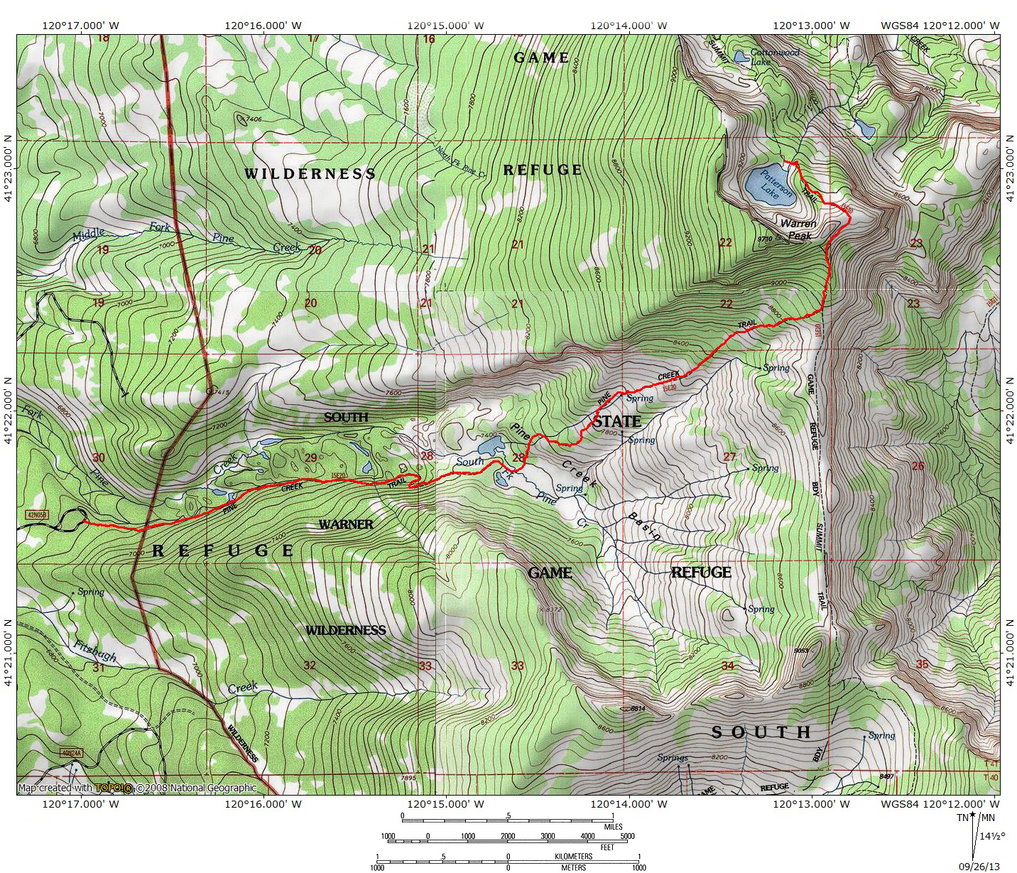
Total Distance: 8.4 miles (to Warner Mountains crest), 10.5 miles (to Patterson Lake)
Elevation Gain: 2,150 feet (to Warner Mountains crest), 2,550 (to Patterson Lake)
Season: Summer, Fall
Warners Direct

Pine Creek flows through Pine Creek Basin.
The Warner Mountains are one of the great unknowns among California’s mountains. Few know of them, fewer still set foot in their demesnes. Those who do tread the earth in this remote place have the pleasure of imbibing the beauty of one of the superior mountain ranges in Northern California. Here hikers have the opportunity to enjoy high desert elements of the Great Basin mixed in fine fashion with alpine elements of the nearby Cascade Range. The result is a splendid group of mountains that will no doubt leave their mark on those who make the trek from civilization to this remote corner of northeast California. Of course, being so far from population centers is one of the reasons why the Warners are often seen as a backpacker’s mountain range. Having traveled all the way out to this forsaken corner of the Golden State, it is difficult to imagine just hitting the trail for a single day. Compounding this is the lack of trails that are suitable for single day outings. Most trails in the Warners access the Warner Summit Trail. Generally the best destinations along this amazing path are realistically reached on backpacking trips rather than day hikes. The biggest exception to this expectation is the Pine Creek Trail. This trail affords hikers direct access to Patterson Lake and travels through amazing country en route to incredible views and the aforementioned lake, the finest in the Warners.

Cliffs above dry, meadow-filled Fourth Lake.
Among the most diverse trails in the Warner Mountains, the Pine Creek Trail passes through a variety of landscapes and different kinds of terrain. Beginning in deep forest, the trail passes alongside rushing creeks and a handful of small, unusual lakes. Unusual volcanic rocks line the trail, indicating the Warners’ geologic history. Tall cliffs mark increasingly rugged character of the canyon. The path eventually emerges at the foot of massive Pine Creek Basin, a vast bowl filled with sagebrush, wildflower and grassy meadows. Numerous springs birth a host of small streams that combine to form Pine Creek. The trail climbs up the basin to the crest of the Warner Mountains where expansive views drop away to the east, west and south. Continuing to the north the trail climbs a short rise and finally descends down to Patterson Lake. Considering the amazing diversity of this trail, the beautiful scenery and the epic vistas, this is easily one of the best day hikes in the North State.

Warren Peak and Patterson Lake.
While the Pine Creek Trail can be done as a single day hike up to the crest of the Warner Mountains or over to Patterson Lake, it can also be combined with other trails to make fantastic multi-day backpacking trips. One obvious connection is to use the Pine Creek Trail to access the Warner Summit Loop. Though this is not often done, it would provide one of the more spectacular access routes to that incredible journey. Another, more manageable option is to combine the Pine Creek Trail with the segment of the Summit Trail with the Squaw Peak Trail to form a spectacular lollipop. This route is good for a two or three night trip.
The Trail

Wildflowers at Second Lake.
The Pine Creek Trail begins in a grove of aspen trees just to the south of Pine Creek. The level path sets out to the east, leaving behind the aspens and entering a forest of mixed pine and fir. Maintaining a level grade, the trail is easy and pleasant and shaded. Soon after leaving the trailhead, the path nears Pine Creek, which runs parallel to the trail. Though its flow may be diminished later in the season, this is a fairly reliable stream and adds a lot of interest to the trail through what would otherwise be attractive but monotonous forest. After 0.35 miles from the trailhead, the route crosses into the South Warner Wilderness. The level grade is sporadically punctuated with some moderate uphill pitches. At times the creek veers away from the trail it is generally audible. The first notable change comes 0.75 miles from the trailhead, when the path arrives at First Lake, a shallow, often swampy pond. It is fairly unimpressive. The most interesting sight is the large rock wall. Though it looks like a dam, it does not seem to impound any water. The trail continues to the east, now climbing persistently alongside the dry gully of one of Pine Creek’s season tributaries. Another 0.75 miles brings the trail to the junction with a trail that descends down to Second Lake. This is a much different body of water than First Lake. Deep and blue, the small lake is nestled in a deep, intimate basin. A profusion of wildflowers and a large spring mark the north end of the lake. This is also the first appearance of a strikingly unusual white, striated rock that is one of the highlights of the first part of the Pine Creek Trail.

Unusual rocks along the Pine Creek Trail.
Beyond Second Lake, the trail continues to climb moderately. It soon passes a small pond with a lush, mossy slope above it. Heading off the trail to the left, there is a large crater that is filled with volcanic rock and the unusual white rock that first appeared at Second Lake. The rock has look of volcanic tuff, a formation composed of ash that has been compressed to form rocks and cliffs. Though it is uncertain what the actually process that created this rock is, it is a fascinating and bizarrely beautiful feature of the Pine Creek Trail. The rock becomes more prominent as the trail progresses but these initial formations by the unnamed pond are the most easily accessed and it is worth the time to explore the area and examine the rocks.

Pine Creek Basin beyond Third Lake.
Continuing on the Pine Creek Trail, the path soon makes a climb through two long switchbacks. Along the way the trail passes ever more elaborate examples of the unusual white rock. Beyond the swithbacks the trail resumes a level grade through the woods. After following this course for 0.4 miles, the Pine Creek Trail reaches another junction. Veering off the trail to the right leads to the edge of scenic Third Lake. The small body of water is fairly deep, is ringed with lush meadow and has the first good view of the upper reaches of Pine Creek Basin. There is a great campsite on the west side of the lake. A well-established use trail skirts the north end of the lake and reconnects to the main path. At this point it is possible to head north, off the Pine Creek Trail and head to the stunning shore of Fourth Lake. Though often dry, this lake boasts a spectacular backdrop, highlighted by tall cliffs that are reminiscent of the massive cliffs above Patterson Lake. Even when the lake is dry, the shallow basin is filled with meadows. Here one also finds the most impressive and elaborate examples of the unusual white rock.

Pine Creek crossing.
Beyond the lakes, the trail finally leaves the forest behind and enters the meadows that fill vast Pine Creek Basin. The sight of the vast basin, rising up to the rocky crest of the Warner Mountains is a memorable vista. It is a surprising mix of sagebrush, meadows, willows, wildflowers, aspens and pine trees. Through all of this a multiple forks of Pine Creek, whose source is a number of springs in the upper reaches of the basin. Where the trail first emerges into the incredible scene all the various spring-fed streams have all been collected into a single channel but higher up there is a vast web of running water. Once in the meadow, the trail appears to hug the right bank of the creek. Don’t follow this path, which is not the actual trail. Instead, look for large cairns on the far side of the creek. These rock piles mark the actual route, which heads north across the creek and enters the dense forest canopy once again.

Pine Creek Basin.
Once the trail has reentered the forest, it begins to switchback in earnest. The grade, though not excessively steep, will not lessen until the trail tops out on the crest of the Warner Mountains. Fortunately the trail does not remain in the woods for long, soon bursting out into the open basin once again. Though the trail passes through an occasional aspen grove, it maintains fairly constant views from this point onward. The views are particularly impressive to the south, into the heart of Pine Creek Basin. Tall, rounded peaks line the perimeter of the basin. Lush meadows are contrasted against a thick blanket of sagebrush. The trail winds its way through the northern reaches of the basin, periodically crossing small spring-fed streams that race toward the bottom of Pine Creek Basin. After nearly 0.65 miles of climbing, the trail finally leaves the bulk of the streams behind, and enters the drier, higher portion of Pine Creek Basin.

Warren Peak looms high above Pine Creek Basin.
As the trail climbs, the summit of massive Warren Peak comes into better view. Large rock outcroppings line the cliffs leading to the peak. The uppermost portions of the cliffs are surprisingly covered with sage and stunted white bark pines. This is in sharp contrast to the north side of the peak which is marked by massive cliffs above both Patterson and Cottonwood Lakes. Eventually the trail comes within earshot of one final stream. Though it can be heard, the trail never crosses the creek nor is it visible at any time. The lack of access to water is compensated by the view of a large volcanic, badland-like dome near the Warner Crest. The trail is climbing toward saddle between this dome and the summit of Warren Peak. As it makes this climb, the path begins to switchback more frequently. It enters a large patch of short white bark pines. Though the trees now filter the views, solace is found in the fact that the trees mark the final leg of the journey to the crest of the Warner Mountains.

Incredible view from the Warner Summit Trail.
The trail steepens as it nears the Warner Crest. For those only interested in hiking to the crest, it is advisable to leave the Pine Creek Trail just below the junction with the Summit Trail and make a short cross country jaunt over open terrain. This will put the hikers on the Summit Trail about 100 feet below the Pine Creek Trail’s junction. The views from the crest are tremendous and make a fantastic destination even if not heading to Patterson Lake. To the west extends Pine Creek Basin, fading off into the vast expanse of the Modoc Plateau. In the distance rise the great cones of Lassen Peak and massive Mount Shasta. To the east is Nevada and the seemingly endless braids of the Great Basin, unyielding until it is overcome by the Wasatch Mountains in distant Utah. Immediately below the east side of the crest is awesome Owl Creek Basin, filled with its own compliment of meadows and springs. On the far side of the basin rise the summits of Dusenberry Peak and mighty Eagle Peak, highest point in the Warner Mountains. Far below is Surprise Valley, which lies between the Warners and the endless mountains of Nevada. The dry beds of the Alkali Lakes stand in dramatic contrast to the irrigated fringe that supports the ranches outside of the small towns of the Cedarville and Eagleville.

Patterson Lake and Squaw Peak.
To reach Patterson Lake, hike north on the Summit Trail. The trail climbs about 400 feet in 0.45 miles to a pass that also boasts remarkable views to the south, taking in the entirety of Owl Creek Basin. Unusual volcanic rocks mark the last pitch of the trail just prior to reaching the pass overlooking Patterson Lake. From the pass the trail drops 300 feet down to incomparable Patterson Lake. As the trail descends down to the lake is passes through excellent wildflower fields and serves up wonderful views to the north, taking in much of the northern extent of the range. The view is highlighted by a chance to look down on Squaw Peak, one of the more prominent summits in the South Warner Wilderness. Though there are larger and deeper lakes in Northern California, Patterson Lake is set apart from the others by its incredibly unique setting. Strangely layered cliffs rise 600 feet above the large lake, revealing the legacy of multiple lava flows that have been uplifted by the same geologic forces that pushed up the entire Warner Mountains Range. Whatever the cause of its creation, Patterson Lake and the Warner Mountains will endow all who see it with a deep sense of gratitude for being able to stand in such a phenomenal place.
Directions

Looking down on Owl Creek Basin, the Surprise Valley and Nevada.
From the junction of Highway 299 and Highway 395 in Alturas, head south on Highway 395. At the south end of downtown, turn left (east) on County Road 56, which is also named E. McDowell and Parker Creek Road, depending on where on the road you are. The road winds for 13 miles, climbing up to a levee and passing a reservation casino before dropping into a shallow canyon. Views of the west slope of the Warners are excellent. Eagle, Warren and Squaw Peaks are prominently visible. Eventually the road enters Modoc National Forest and becomes Forest Road 31. Although the pavement ends the road is in excellent condition and is passable by sedans. After 13 miles the road reaches a junction with County Highway 5, a good, gravel road. Turn right and head south on Hwy. 5 for 9.8 miles to the signed turnoff for the Pine Creek Trailhead. Turn left and proceed to the end of the road.

Pingback: Year One of Hike Mt Shasta | Hike Mt. Shasta
We hiked up to the crest on 7/19. Our GPS had the mileage out and back to the crest at 10.4. What a great hike, and beautiful basin and views. Wildflowers are at their peak right now.
I Karen! Sorry it has taken me a little while to respond. Regarding the distance to the crest, I have gotten a couple of different GPS readings on that trip. I tend to go with the one distance, though I could be wrong for doing so. I am glad you had a great trip. Those really are spectacular mountains!
Thanks for these great descriptions! I’m planning to do the Pine Creek Trail this week as a day hike from Alturas (where I’ll be staying). How long is the drive from Alturas to the trailhead, and is the very last part of the road to the trailhead passable for sedans without 4wheel drive? Thanks!
Hi Marilyn. Thanks for checking out the site! I honestly can’t remember how long it took from town to the trailhead, but I am pretty sure it is under an hour. It has been a few years since I was there, so I can’t be 100% sure about the road conditions but in the past it did not need 4×4.
Dear Bubbasuess (not sure what other names you have), Thank you, thank you ,thank you so much for this excellent description of Pine Creek Trail! I hiked it today, to the Summit Trail and on to the pass, and the Patterson Lake overlook, where I had my lunch perched on a rock with breathtaking vistas and a light breeze to temper the sun. Didn’t quite have time to drop down to Patterson Lake before heading back, and my 70-yr old legs were getting a bit tired. But it was a fantastic experience and I don’t think I could have done it without your trail description as a guide. Again much appreciation and happy trails!!
I am really glad you made it up there! That is certainly one of the most spectacular areas in this part of California. It has been a few years since I have been there and my wife and I are itching to get back. Your heading up there and enjoyment of it has certainly inspired us to get over there again!
And yes, Bubba Suess is actually my name. It’s my parent’s fault!
I like these write ups, but don’t trust your tree identifications! The “Aspens” are Cottonwoods, hence the name Cottonwood Canyon, Trail, etc.. There are no Red Fir, which is typical of the elevation in the South Warner’s. There are rare Mountain Mahogany and a lot of sickly looking white fir. White fir almost always looks sickly.
Distrust all you like, but I assure you, those are aspens. As far as firs, I never identified them as red firs. I am not sure where you read that.
The “Aspens” are Cottonwoods. There are no Red Fir (usually found at that elevation). There are rare Mountain Mahogany and a lot of White Fir.
Please check out the pine creek basin it is being destroyed by the cattle the area foresters are afraid of the ranchers and should be. The word needs to get out to the public about what is happening here if we are to save this still special wilderness.
Sharon, please stay home in the Bay area. Thank you.