
At A Glance
The Highgrade Trail travels through remote country in the far northeast corner of California. Typical Warner Mountains terrain abounds and there are far reaching views into California, Oregon and Nevada nearly every step of the way.
Total Distance: 3.2 miles (to Mount Vida)
Elevation Gain: 800 feet (to Mount Vida)
Season: Summer, Fall
Explore the Northeast Corner

The Surprise Valley from Mount Vida.
What scant attention is paid to the Warner Mountains is understandably focused on the spectacular South Warner Wilderness. The rest of the range, which stretches into Oregon 50 miles north of the wilderness’ northern boundary, is largely forgotten. This means the few trails in the Warners outside of the wilderness area are nearly abandoned and are havens for those who seek solitude and isolation. The Highgrade Trail travels remote country in the northernmost reaches of the range. It is probably the most scenic trail outside of the South Warner area. Possibly the northeasternmost trail in California, the trailhead lies only 2.75 miles from the Oregon border and 11.5 miles from the border with Nevada. Though the route is among the shorter and easier trails in the Warners, it does not lack exceptional scenery. The majority of the trail follows a ridge with fantastic views in all directions, including distant Mount Shasta and Mount McLoughlin. Seldom explored basins and lonely peaks surround the trail, giving hikers the sense that mystery surrounds them on all sides. Aside from the great views, it is the air of deep seclusion that is the real draw of this path. Despite not rising to the level of the magnificent trails in the South Warner Wilderness, the Highgrade Trail is still an excellent journey into isolation.

Dry Goose Lake seen from the Highgrade Trail.
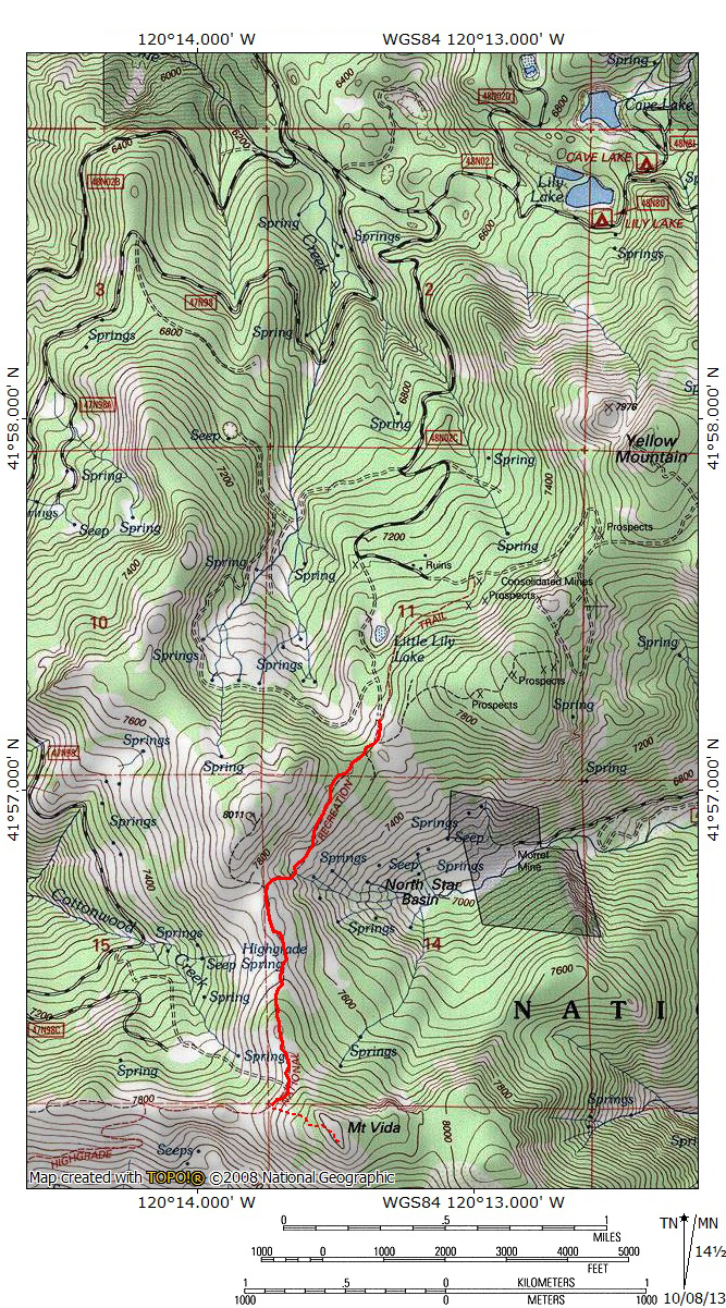
Though the Highgrade Trail is 3.5 miles long, the first 1.5 miles are the most interesting and the most likely to be hiked. In truth, the Highgrade National Recreation Trail follows the route of an old jeep road along a high ridge in the northern Warner Mountains. The road was once used to connect rarely used roads that traveled the upper reaches of the Warners. The road was eventually condemned and designated a National Recreation Trail. If there are significant complaints about the trail they are that the entire length of the trail does not leads to a specific destination (because it simply connected roads) and that it is simply and old road, not a classic single-track trail. Fortunately, there is a fantastic destination along the trail that makes a fitting conclusion to a hike along the first half of the trail. The Highgrade Trail passes a few hundred feet below the summit of Mount Vida, one of the highest points in the northern part of the range. Views from the summit are superb.
The Trail
The last section of road leading up to the Highgrade Trailhead can be very treacherous when it is wet. In particular, the final climb up to a large flat saddle where several roads converge can become too slick for vehicles to climb. It may be necessary to park below this section of road and hike the short climb up to the parking area at the saddle. Although the official trailhead is 0.25 miles further up the road from the parking area, the Highgrade Trail essentially begins at the saddle above the steep, potentially hazardous section of the access road. For those parking below the steep, muddy section, the road levels off at the saddle and begins to round the southern edge of Point 8,011.

Mount Vida looms near the start of the Highgrade Trail.
The trail initially passes through a light forest. The route, which is really an abandoned jeep road, enters into large patch of corn lilies. Views begin to open up, with views of Mount Vida to the south and the large bulk of flat topped Mount Bidwell to the east. Soon the level trail begins to decline, gradually at first and then precipitously. The forest is left behind and grass and sage cover the mountain predominantly. The trail, which was engineered for 4×4’s and not people drops and climbs at grades that seem unreasonable for foot traffic. The reason for the routing is a large band of cliffs at the top of the North Star Basin headwall. As one descends around the cliffs, views of the basin continue to open up. Mount Vida remains a constant presence to the south. After descending, the trail immediately climbs to the saddle between Point 8,011 and Mount Vida. This is the steepest part of the entire route. If the trail is muddy, stay off of it and try to step on the rocks either side of the route.

Looking down into North Star Basin and distant Fort Bidwell.
Once one reaches the saddle, hikers are beset by a host of views. On the western horizon rise the distant towers of Mount Shasta and Mount McLoughlin. Other visible landmarks include the Mountain Lakes Wilderness in Oregon and the Medicine Lake Highlands in California. Goose Lake is an immense presence nearly 3,000 feet below the saddle. The eastern edge of the saddle provides the best views of the interior of North Star Basin as well as of Mount Bidwell. Though it is not visible from the trail, there is a large mining claim from inside the basin. Mount Bidwell might hold the distinction for being the northern and easternmost peak in California. Once following the top of the crest, the path continues to the south and follows the crest of the ridge as it heads 0.6 miles to the base of Mount Vida. This section of trail is reminiscent of section of the Warner Summit Trail that is high above Pine Creek Basin. This is due to the barren Warner crest and the great views.

Crane Mountain in Oregon, northernmost peak in the Warners.
The Highgrade Trail does not actually reach the summit of Mount Vida. Instead, in continues south, routed around the base of the summit. It eventually intersects another Forest Service Road. To reach the summit of Mount Vida, simply turn left off the trail and pick one’s way through the stunted lodgepole and white pine to the summit. From the route, a rocky outcrops forms a bit a false summit, the actual highpoint is located about 50 yards further south. Views from the summit are tremendous. To the north the Warners extend into Oregon, culminating in Crane Peak. Beyond the Warners, the Drake Peak area lines the horizon. To the east, the unending Great Basin extends into Nevada. To the west the cones of Mount Shasta and Mount McCloughlin vie for dominance of the skyline. To the south, the views heads straight down the length of Surprise Valley. The high towers of the South Warner preside majestically over the valley.

Looking down the last leg of the Highgrade Trail.
If climbing up to the great views atop Mount Vida is not enough, it is possible to continue on the Highgrade Trail for another 2 miles to its southern terminus along a dirt road. From the point on the Highgrade Trail where the scramble to the top of Mount Vida begins, the trail makes a sharp turn to the west. It continues along the Warner crest for another 0.4 miles. It then begins a series of switchbacks that descends into Mill Creek Basin. Here the trail narrows to a more typical single track. Be wary, because the dirt road continues along the crest before eventually petering out. Once the switchbacks are completed, the trail makes a broad traverse above the headwaters of Mill Creek. Finally, 1.3 miles from the bottom of the final switchback, the trail arrives at the final tailgate. To return tot he trailhead, it is necessary to retrace your steps.

Lily Lake.
One interesting sight to note is nearby Cave Lake and Lily Lake. The Highgrade Trail does not pass these two small lakes but the drive to the trailhead passes the road that leads to them and they only take about a minute to reach. It is worth stopping at them after a hike on the trail. For those interested in spending a weekend in this forgotten country, there are small campgrounds at the lakes. It is possible that Cave Lake and Lily Lake are the northernmost mountain lakes in California. Cave Lake is only 0.85 miles south of the Oregon border and Lily Lake is just a few feet further away. Though neither lake is spectacular, they have a quiet, lonely beauty. As the name suggests, Cave Lake does have a small cave at its north shore.
Directions

Cave Lake.
From Alturas, head north on Highway 395. A little over 0.5 miles south of the Oregon border, turn right on signed Forest Road 2. After 0.5 miles, the road becomes unpaved but is in excellent condition and easily traveled by low clearance vehicles. Continue east for 5.1 miles to a signed intersection for Consolidated Mines. To reach Lily and Cave Lakes continue straight 0.5 and 1 miles respectively. To continue to the trailhead, turn right at the intersection. The road continues another 2.6 steep miles to the trailhead. While all but the very end of the road should be passable by low clearance vehicles, those concerned about their cars should park at the intersection and make the hike up the road. For those headed to the trailhead, continue south, climbing steeply. At 1.1 miles, stay to the left at a junction and another 0.6 miles stay to the right. Stay left at one more junction, another 0.4 miles further. The road continues another 0.5 miles from the trailhead. However, about 0.25 miles before the trailhead, the road breaks out of the forest and traverses a steep slope. It is highly recommended that one park at the base of the slope if there is any kind of moisture on the ground. Although the road may seem solid, the dirt can be incredibly muddy and slippery. Even in a high clearance 4×4, the mud can be too slippery and the danger of sliding off the road and highcentering on the steep slope is very real (this admonition is based on personnel experience). At the top of the slope is a large saddle with a flat parking area. The signed trailhead for the Highgrade Trail is another 0.25 miles south. Just walk the last bit of road to the trailhead.

That was way more detail than I was expecting. Thanks a lot!