
There are changed trail conditions on the Whitney Falls Trail. Read about them here.
At A Glance
A lower elevation route on the north side of Mount Shasta that leads to a great waterfall…when it is flowing.
Total Distance: 3.2 miles
Elevation Gain: 800 feet
Season: Spring, Summer, Fall
A Fickle Falls

Mount Shasta, Shastina and Whitney Falls.
The Whitney Falls Trail accesses the lower flanks of Mount Shasta’s northwestern side. Although the trail was initially constructed to serve as an approach to the climbing route that ascends the Whitney Glacier, today it functions primarily as a hiking trail that leads to an overlook of Whitney Falls, one of the four named waterfalls on Mount Shasta. The reason for this change in function is twofold. The primary reason for the change is sporadic glacial debris flows that were released from the Whitney Glacier and burst violently down Whitney Creek. The latest of these occurred in 1997 and almost completely destroyed any trace of the trail for about 0.3 miles. Due to the continual and severe trail damage or outright obliteration, the Forest Service decided to end maintenance and reconstruction of the trail. Consequently, trail use decreased, which led to those parts of the trail that were not damaged by the flooding becoming badly overgrown by manzanita. All told, the Whitney Falls Trail is in an extremely sorry state of disrepair.
The poor condition of the trail aside, there are still several reasons why the Whitney Falls Trail warrants exploration. First and foremost, it leads to a fickle but beautiful waterfall. Whitney Falls’ flow can vary significantly, but when it is good form, it falls about 250 feet into a narrow, lava flow capped canyon. Depending on which variation (more on that later) of the trail one takes, there are great views of Mount Shasta and Shastina, as well as the Whitney and Bolam Glaciers. Also worthy of significant consideration, the trail is one of the lowest trails on Mount Shasta and, added its location on the dry northern side of the mountain, means that it is open far earlier in the season than the rest of the trails on Mount Shasta.

Mount Shasta and Bolam Creek from the trailhead.
The glacial debris flows have occurred periodically on Mount Shasta. The worst in modern times happened in the 1920’s as a result of the retreat of the Mud Creek Glacier. According to Selters and Zanger, debris from these out bursts even clouded parts of San Francisco Bay, at the terminal end of the Sacramento River system. The Whitney debris flows, though not nearly that large, have proven to be destructive. Aside from destroying the Whitney Falls Trail, the debris flows covered the trailhead in up to 5 feet of rock, ash and silt, shut down Highway 97 and threatened many homes near Lake Shastina. More information can be found here. A dramatic video of the debris flows is available here.
It seems that the rate of degradation of the access road, the trailhead and the trail itself are accelerating. In the last few years, the road has gone from one that is passable by low clearance vehicles to a state that almost demands high clearance. The trailhead sign, once mostly buried has all but disappeared. The trail itself continues to be overgrown and confusing in some spots. The falls themselves also provide some frustration. It is always uncertain when they will be flowing. If one crosses Whitney Creek on Highway 97 and there is no water in the channel, skip the Whitney Falls Trail, unless exploration and views of Mount Shasta are all one seeks after. If, on the other hand, there is water, then the Whitney Falls Trail, despite all of its drawbacks, is still a beautiful trail that leads to a seldom seen (with water in it) waterfall. This is especially true when the higher trails are still snowbound.
The Trail

Bolam Creek, along the Whitney Falls Trail.
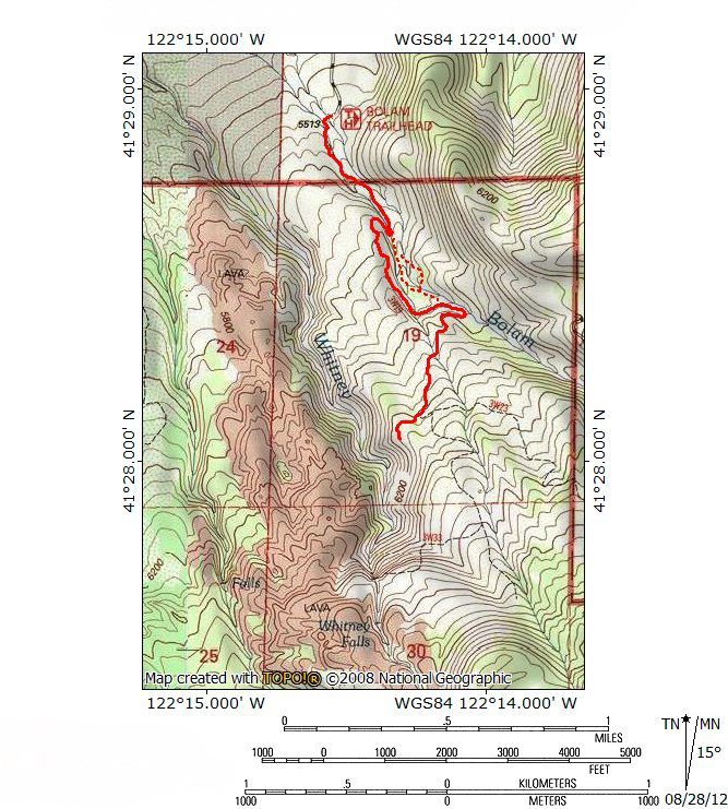
The trailhead for the Whitney Falls Trail is quite small. It probably accommodated more vehicles in the past but now only has room for two or so cars. There is no official signage anymore, the large, buried trailhead sign having recently disappeared. Instead, one simply gets to the end of the road and then begins to hike. Just beyond the parking area, there is a large clearing through which Bolam Creek flows. The clearing was created by the debris flow, spreading several feet of rock, silt, and ash over the area. Bolam Creek has carved a deep channel through the damaged area. Like the large rivers coming off of the great glaciated volcanos like Mounts Hood and Rainier, the creek runs white with glacial detritus. The Whitney Falls Trail actually begins on the far side of the creek, necessitating a crossing of the channel. Unfortunately, there is no established route, which means the loose, constantly eroding soil must simply be descended and climbed, advancing the inevitable erosion. The faint trail is easy to pick up on the far side, complimented by frequent cairns.

Mount Shasta from the Whitney Falls Trail.
Once on the trail, it proceeds south, quickly entering a dry gulch that runs parallel to Bolam Creek. A short distance from the creek crossing, the path makes an unmarked entrance into the Mount Shasta Wilderness. Soon the trail exits the dry gulch and is slung precariously over the eroded edge of the Bolam Creek channel. At this point the trail degrades seriously, ending up as a little more than an deer trail. About 0.5 miles from the initial crossing of the creek at the trailhead, there is a split in the trail of sorts. A very faint path makes a sharp turn to the right, switchbacking closely above the use trail. This marks an attempt to follow the original, pre-debris flow path of the Whitney Falls Trail. This path seems to disappear into dense manzanita, but a little further on the trail opens up comfortably and is passable. This section of the trail has great views of Mount Shasta and Shastina, looming high overhead. However, this area continues to get more overgrown and, barring intervening maintenance, faces an uncertain future. This iteration of the route climbs for 0.5 miles before descending back down to Bolam Creek and rejoining the other variations of the Whitney Falls Trail.

Looking north into the Shasta Valley.
The newer, more consistently used route to Whitney Falls now bypasses the old section of trail and stays close to Bolam Creek. At this point there are two more options. Shortly beyond the departure to the original trail, the use trail comes to a bit of a precipice over the creek. Another faint use trail climbs higher through some thick brush and simply continues south, above Bolam Creek. If one wants to avoid the bit of bushwhacking necessary to complete the aforementioned route, one can descend down into the creek at the precipice and climb back up the other side, to a point marked by cairns. Once on the far side, the cairns continue to mark an easy path through open, rocky terrain for about 0.3 miles. One wonders why the trail is not routed along this side of the creek all the way from the trailhead, since this is easier country to hike through than the brush choked shoulder above the creek. Soon, cairns bring one back to the edge of the creek, marking another, final crossing. Back on the other side, all three variations of the route to Whitney Falls reconvene in a broad level area, created by the creek veering away from the shoulder and off to the southeast, thereby widening the distance between it and the heretofore unseen Whitney Creek.

Shastina and Whitney Falls.
Once the routes all reconnect, the trail leaves Bolam Creek for good and climbs onto the broad divide between it and Whitney Creek. Here the trail once again enters a thick manzanita brush field. Thankfully, the trail is fairly wide in these parts as it continues to climb to the south. Views to the north are excellent along this stretch of trail. After another 0.5 miles through the manzanita, the trail finally reaches a very faint junction. The lesser used path that forks to the left is the old trail that leads towards the Whitney Glacier. This route is badly overgrown, underused, and ultimately irrelevant. A shorter, prettier route with less elevation gain is possible from the North Gate Trail. The fork to the right leads to the viewpoint for Whitney Falls. To reach the overlook, continue along the short trail through some dense trees before being deposited on a sandy bench high above Whitney Creek.

Whitney Falls.
From the bench, Whitney Falls is visible (when it is flowing) thundering about 250 feet over a gray cliff. The constant clatter of boulders rocketing over the falls is distinctly audible, evidence that the contours of the mountain are ever in flux. Mount Shasta and Shastina peer over the top of a tree covered rise beyond the falls. Below Whitney Falls is Whitney Creek Canyon, a gorge typical of the larger flows of water on Mount Shasta, though much smaller than Ash Creek and Mud Creek Canyons, the two giants on the southeast corner of the volcano. The sides of the canyon are generally loose scree, still in search of its ultimate angle of repose. Like Ash Creek and Mud Creek Falls, the waterfall occurs where a band of erosion resistant rock cuts across the canyon, forming a sheer precipice the water must fall over rather than wash away. One unique feature of Whitney Creek Canyon is the lava flow that caps the western side of the canyon. Thick, tangled black lava is clearly visible above the falls and continues to line the western canyon rim for a mile. Beyond the lava flows, the Shasta Valley and Klamath Mountains far beyond are clearly visible. However, it is the falls themselves that constantly draw the attention southward.
Directions

Whitney Creek, below Whitney Falls.
From the beginning of Highway 97 in Weed, drive northeast for 11.8 miles. Turn right onto Bolam Road, which is also Forest Service Road 4321. This is the last major turn to the right before Highway 97 intersects County Road A12 on the left. Once on Bolam Road, proceed 0.3 miles to an intersection, staying to the right. Continue 3.7 miles to the roads end at the trailhead.

Pingback: Mount Shasta Area Waterfalls: Three Falls On The Mountain | Hike Mt. Shasta
Pingback: Wild Water: The 5 Best Hikes On Rivers And Creeks | Hike Mt. Shasta
Pingback: Whitney Falls Trail Washed Out | Hike Mt. Shasta
Whitney Creek is from melting of snow/ice above the falls. Naturally, there will be little if any water in Whitney Creek in the mornings. It usually flows in the afternoon, depending on how much sun gets to shine on the pack above. If a cloudy day – it will probably not be worth the hike.
Pingback: Whitney Creek Flowing Strong | Hike Mt. Shasta
Pingback: The Changing Channel Of Whitney Creek | Hike Mt. Shasta
Pingback: Hike Mt. Shasta
Pingback: A Mount Shasta Reader | Hike Mt. Shasta
May 5, 2019. I hiked to the viewpoint for Whitney Falls today. The trail is not in good shape in some places. It required a bit of bushwhacking and navigation but we found our way. The view of the canyon was lovely, but there was not a drop of water at the falls. I don’t know if it’s too early or too late to see water there. I may try again in a couple of weeks.
I wouldn’t try it until you see water going under Highway 97. It likely won’t run until late June or July.
Pingback: Strong Flow On Whitney Creek – A Good Time To Hike Whitney Falls | Hike Mt. Shasta
Pingback: Mount Shasta Social Distancing Hikes Part I: Waterfalls | Hike Mt. Shasta
I hiked to the falls for the first time Sunday 4/11/21. Finding and following the trail was difficult in some places. The snow covered long stretches and the trail is not well marked. Otherwise it was a nice hike the falls were not flowing but it was still a neat place and I will try again this summer.
PS: I’d be willing to help maintain the trail if you are still looking for volunteers. I have lop shears and other hand tools.
The trail is in rough shape but it shouldn’t take too much work to get it back up to speed. Maybe just a day, if enough people work on it. How was the creek crossing right at the trailhead?
Also, for what it is worth, the falls don’t really run until it get hot in the summer and the glaciers melt. The trail is accessible early but the falls will leave you wanting.