
At A Glance
A great hike along the Pacific Crest Trail to two excellent lakes at the head of the Middle Fork of the Sacramento River.
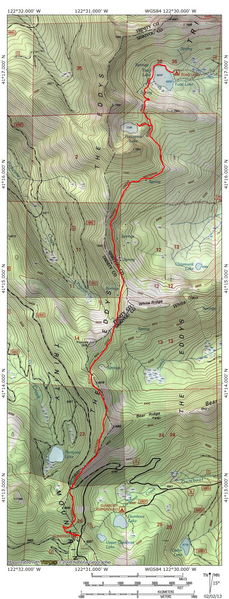
Total Length: 11.5 miles (to Porcupine Lake) 13 miles (to Toad Lake Campground)
Elevation Gain: 1,300 feet
Season: Summer, Fall
Porcupine and Toad

Porcupine Lake and Porcupine Peak.
Porcupine Peak is reached by following the Pacific Crest Trail for 5.6 miles north from Gumboot Saddle, traversing the Eddy Range just below its crest nearly the entire distance. The route is easily graded and provides spectacular views nearly the entire distance. Among the highlights are the ever-present views of Mt. Shasta, the regions highest peak and one of the tallest and most massive mountains in the Lower 48. The trail crosses through open, rugged terrain for much of the trip, but it does pass through old growth forests and lush meadows as well. Once Porcupine Lake is reached via the PCT, it is necessary to scramble 0.5 miles to the summit. It is also possible to drive as far as Toad Lake, which is 0.4 miles from Porcupine Lake and 300 feet lower, but the drive is long and difficult, traveling over poor roads. It is easier to simply make the beautiful trip along the PCT and this is the preferred route to Porcupine Peak.
The Trail

Porcupine Peak and Mount Eddy from the PCT.
The route to “Porcupine Peak” begins on the PCT at Gumboot Saddle. The trail sets out to the north, climbing a couple of switchbacks before settling into a roughly due north trajectory, along the flanks of “Gumboot Mountain”. The PCT remains on top of or just below the crest of the Eddy Range until reaching the junction with the trail to Porcupine Lake. The trail passes through generally open country, with views to the east of Mt. Shasta. After 0.75 miles the trail descends to a saddle and crosses Forest Road 40N45, though it is unmarked where the crossing takes place. The PCT is visible across the road and not difficult to find. It is possible to turn onto 40N45 from Forest Road 26 prior to reaching Gumboot Saddle, consequently shaving off nearly a mile of the trip to “Porcupine Peak”. Though the road is gravel, it is in good condition. Although this shaves a fair amount of distance off the trip, the views from the beginning of the trail are worth the extra distance.

View of Mount Shasta from the PCT.
From the road crossing, the PCT continues north, this time traversing the western face of the Eddy Range. One passes beneath the western terminus of Bear Ridge, which extends eastward from the main crest of the Eddy Range. Large but shallow Picayune Lake can be seen to the west, 600 feet below the trail. Picayune Peak is the highpoint immediately to the north. Beyond Bear Ridge, the trail continues north, passing through two saddles in rapid succession. At the second saddle, it is possible to depart the trail to the southwest and climb easily to the summit of 7070 foot Picayune Peak.
Beyond the second saddle, White Ridge extends eastward, off of the crest of the Eddy Range, similar in many respects to Bear Ridge, although it is a little higher. The trail crosses over the western face of the ridge, with good views westward. A small but fairly reliable spring is found about 20 feet below the trail in this section. For PCT travelers, it is the first water in nearly 15 miles. Watch for lush grass and damp ground around the trail.

Porcupine Lake.
Once past White Ridge, the PCT reaches another saddle, this time crossing back over to the eastern face of the crest of the Eddy Range. A large meadow appears below the trail, providing excellent views of Mt. Shasta to the east. This meadow is often filled with an excellent display of wild flowers. Small springs provide the necessary water for the meadow but are not productive enough to resupply hikers. After the meadow, the PCT begins a wide arc to the east, passing beneath Porcupine Peak. Another small meadow filled with carnivorous Pitcher Plants is found just south of the trail along this stretch.
Soon the PCT turns north again, rounding the base of Porcupine Peak. Views of Mt. Shasta and the Castle Crags Wilderness are excellent. Up until this point, the trail has been remarkably level and only now begins to make a noticeable climb, although this too is very moderate. As one turns north, it is necessary to watch for a small cairn marking the junction with the route leading up to Porcupine Lake. It is possible to miss this junction, though it is fairly obvious. From the PCT simply hike up the use trail to the lake.

Toad Lake.
Once at Porcupine Lake, the route to the summit is found along the southern side of the lake. Scramble over the abundant boulders along the southern shore, climbing higher as one goes. The eastern end of the lake is level, while the base of Porcupine Peak forms the wall at the southern end of the lake. Be sure not to attempt to climb straight up the wall. Instead, angle to the west, traversing the lower portion of the peak. It is not possible to accidentally stay at the waterline, since a small set of cliffs disrupts the navigable part of the shoreline. Continue towards the western end of the lake, climbing gradually. Once the trees get denser, turn to the left and head southeast up the steep slope to the summit. It is a steep, rocky scramble, but it should not be difficult to achieve the top of Porcupine Peak.
To reach Toad Lake, return back to the PCT and continue north for 0.25 miles to a junction on yet another saddle. The trail to the right descends 0.5 miles to the shore of Toad Lake, which is much larger than Porcupine Lake, though not as beautiful. Views of Mt. Shasta compensate, however.
Directions

Gumboot Lake and the South Fork Divide.
From the town of Mt. Shasta, head west on W. Lake, crossing over I-5. At the stop sign, turn left onto Old Stage Road. After 0.25 miles, veer right onto WA Barr Road. Continue south, crossing over the dam that impounds the Sacramento River and forms Lake Siskiyou. At the intersection with Castle Lake Road, stay straight. The road becomes Forest Road 26. Follow this road for nearly 12 miles. A signed fork indicates Gumboot Lake is 0.5 miles to the left. Continue to the right, climbing up the cirque that contains the Gumboot Lakes. The PCT Gumboot Trailhead is located at the summit with a good parking lot.

Pingback: A Mount Eddy Wilderness? | Hike Mt. Shasta
Pingback: Gumboot Saddle: Two Hikes On The Pacific Crest Trail | Hike Mt. Shasta
Nice to see and hear about Toad Lake! I am almost finished with The Wild and that is where they were said to have this great party, so it’s fun to get a visual to see if the picture in my head–from the details of the book–are somewhat accurate. Great depictions and illustrations of the trails! I can’t wait to explore this (your!) part of the country!
I loved your depiction of Toad Lake! It’s especially fun to read about as I’m finishing up the book The Wild, and they were looking forward to a big party there at Toad Lake along the PCT. When I was in Oregon last month I also got pretty excited every time I saw the signs for the PCT making my book come even more to life as I read along! I can’t wait to explore that (your!) part of the country!
Thanks for the great website! Have you thought of making this a book? Something we could carry in the backpack while hiking. I would buy it and I bet many others would also.
I really, really appreciate that! It just so happens something big is in the works with a publisher but mum’s the word on that for a little longer…
Thank you for putting up such a wonderful website
My girlfriend and I are a little new to hiking and would like to know if there are any hiking clubs or hiking wilderness clubs in the Mount Shasta area we live in Dariyville , red Bluff area
We are very interested in doing 2 to 3 day wilderness hiking camping trips
Thanks for the feedback on my site. I hope it comes in handy. As far as overnight stuff, there is not much in the way of groups around here. The Siskiyou Wanderers are a hiking group that meet weekly. You might also try the Chico Hiking Association, which is pretty active and has folks from Red Bluff and Los Molinos in the organization. If you are new to backpacking, you ought to just head out for a night and jump right in. Don’t get ambitious, just pick a destination that is easy to get to and figure out what works and doesn’t work for you.
To find fellow hikers in this (or any) area, you should check out the website http://www.meetup.com and enter the area you want to hike and your interests (i.e, backpacking, hiking, etc.). I’d suggest some of the Redding, CA groups.
Pingback: Exploring The Sacramento River Headwaters | Hike Mt. Shasta
the deer are big
watch out for bear
Pingback: Gumboot And Parks Creek Passes Open | Hike Mt. Shasta
Pingback: PCT Spotlight – Porcupine And Toad Lakes | Hike Mt. Shasta
The description of the hike was really wonderful.
My wife and I backpacked along this section, and really enjoyed it. To folks newer to backpacking, I’d recommend this section as a start. When tired, take in the beauty. Stay short; water up; check out your gear; and maintain a sense of awe, and a sense of humor. Peace!