
At A Glance
A long trail, much of which is rarely traveled, that passes through one of the best lake basins in the area, visits gorgeous, little-appreciated meadows, and descends through a largely abandoned canyon alongside the North Fork of the Sacramento River.
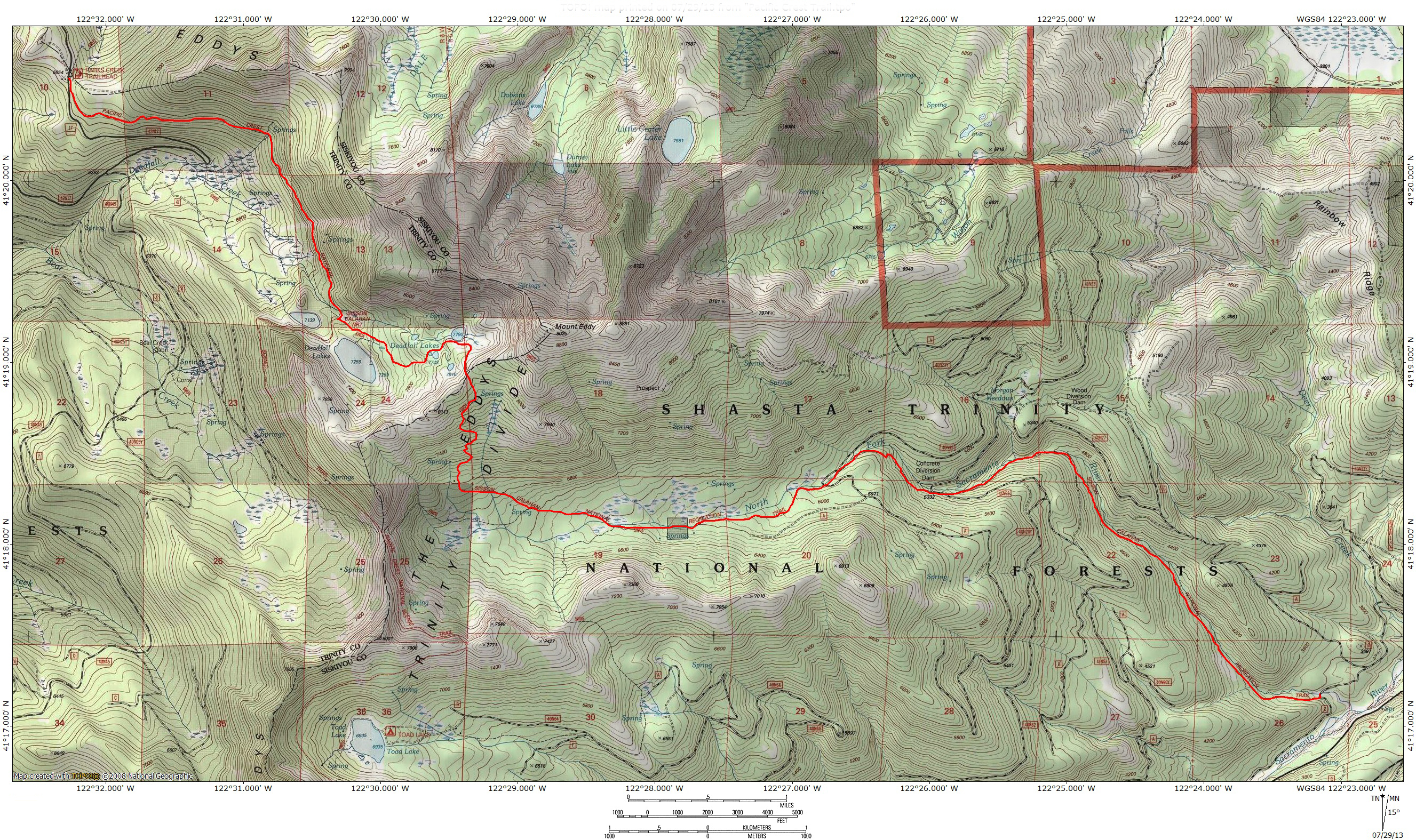
Total Length: 12 miles
Elevation Gain: 1,160 feet (4,500 feet lost)
Season: Summer, Fall (The lowest portion of the trail may possibly be hiked in winter and spring, depending on conditions.)
Historic, Forgotten, and Gorgeous

Mount Eddy from the North Fork meadows.
The Sisson-Callahan Trail (SCT) is the longest trail in the Mount Shasta area, with the sole (and obviously significant) exception of the Pacific Crest Trail. The trail measures a little over 9 miles from the trailhead near the confluence of the North Fork of the Sacramento River with the river’s main fork, to the junction of the SCT with the PCT. Over the course of its journey, the trail follows a beautiful, wild river, passes through narrow canyons, traverses a large meadow complex, climbs out of a rugged, rarely seen canyon and descends through the Deadfall Lakes Basin, one of the prettiest spots in the region. Amazingly, with the exception of the final portion through the Deadfall Lakes, the SCT is one of the least used trails around Mount Shasta. It is through a combination of poor information (or a complete lack thereof) and potential logistical obstacles that the SCT has managed to slip under the radar. Those who accept the challenge of completing the SCT are treated to a wonderful journey with excellent scenery, deep solitude, and possibly the most diverse trail in the region.
The SCT is not only one of the least traveled trails in the Mount Shasta area; it is also one of the most historic. Its course was originally blazed in the 19th century by loggers, miners and cattlemen pushing up the North Fork of the Sacramento. At the time the town of Mount Shasta was known as Sisson. Eventually the route crossed over the crest of the Trinity Divide and descended the Upper Trinity River. It ultimately led to a route that arrived in the small town of Callahan, at the very southern end of the Scott Valley. This linked Sisson with the primary stage coach route that went from Weaverville to Yreka. Early in the 20th century, the Forest Service constructed a proper trail, linking sections that had already been constructed and establishing a new foot route out of the North Fork Canyon and into Deadfall Basin.

The wild North Fork of the Sacramento.
It is likely that the bulk of the SCT receives little use because of the perception that it is a difficult, uphill slog for the entire length of the trip. This is true to a degree. If hikers do begin at the North Fork trailhead, it would be a long 4,500 foot climb up to a high shoulder on Mount Eddy. Fortunately, this does not have to be the case. One of the few descriptions of the trail makes the assumption that it is necessary to begin at the river, climb up to the lakes and then return, meaning a long, 17 miles trip with a significant amount of climbing. Rather than subjecting themselves to a round trip of punishment, it is much more preferable to do the hike as a shuttle. The best way to experience the trail is to park a car at the trailhead along the North Fork of the Sacramento and then drive up to the PCT trailhead at Parks Creek. Hikers can either leave another car there when they depart or, better yet, arrange a ride up to the trailhead so that the car does not need to be retrieved. Setting up the cars and drop-off this way means that hikers must only climb 800 feet up to the trail’s high point on the shoulder of Mount Eddy, rather than climbing 4,500 feet. It also means that the bulk of the trail is a long descent which most would consider preferable to the reverse. However the drop-off and pick-up is arranged and whichever directions hikers go, they are in for an exceptionally scenic experience. The bulk of the trail sees such little use that the odds are good no other hikers will be encountered outside of the Deadfall area, even on weekends at the peak of summer.

A quiet meadow on the upper flanks of the North Fork Canyon.
This description of the SCT will begin at the Parks Creek Trailhead on the PCT and end at the North Fork trailhead, along the Sacramento River. This is the best approach to doing the entire trail, especially if the plan is to complete the trip in a single day. If a shuttle cannot be arranged, then it is better to begin the trail at the North Fork trailhead and just hike the trail along the river for a few miles before returning. Another good option is to push further and hike the nearly 6 miles to the complex of meadows that form the headwaters of the North Fork. The meadow complex is a great place to set up a basecamp and explore the North Fork Canyon. This route has a consistent grade that gains a reasonable 500 feet per mile. Beyond the meadow, the trail makes its brutal ascent out of the canyon into the Deadfall Lakes Basin, a climb that accounts for much of the trail’s overall steep statistical appearance. That section of the trail is best done coming from the Deadfall area.
The Trail

The Scott Mountains from the PCT.
The best place to begin a trip on the SCT is not on the trail itself but on the PCT. Although the PCT is the preferred embarkation point, one can also access the SCT via the Deadfall Lakes Trail, which begins in Deadfall Meadow. If climbing Mount Eddy or hiking only as far as the Deadfall Lakes, this is a much more attractive trailhead because it passes through the extensive upper portion of the meadow and parallels the many spring-fed tributary streams that feed Deadfall Creek. If only going to the more immediate destinations, this is a shorter route, though it does add a noticeable amount of elevation gain. By taking the PCT, hikers add some distance, but it is almost entirely level and requires little effort compared to the climb out of Deadfall Meadow. Embarking on the PCT, the trail departs Parks Creek Pass and maintains a level traverse across the northern flank of Mount Eddy. About 1.5 miles from the trailhead the path crosses a large drainage that may have running water supplied from springs crossing the path. This initiates a sporadic series of seeps and additional springs that cross the trail prior to arriving in the Deadfall Basin. This area also has good views to the north and west, where the Scott Mountains loom close by and the distant Trinity Alps slash at the horizon.

Mount Eddy rises above an unnamed Deadfall tarn.
Upon arrival in the Deadfall Basin, the PCT crosses over one of the tributaries of Deadfall Creek and encounters a trail junction. To the right is the trail climbing out of Deadfall Meadow. Straight ahead is the PCT heading north from the Eddy Range. To the left is the beginning of the SCT and its climb through the heart of the Deadfall Lakes. This is the most popular and heavily used part of the SCT, with good reason. The basin is spectacular. Three beautiful lakes and a handful of unnamed tarns dot the basin, including Middle Deadfall Lake which is nearly 25 acres and Upper Deadfall Lake, which is the prettiest of the bunch. The lake is ringed with lush meadow and stunted trees, behind which is the towering bulk of Mount Eddy, rising 1,200 vertical feet overhead. This is the steepest part of the entire trip, especially the climb directly after Middle Deadfall Lake. It eventually levels off, passes an unnamed tarn before reaching the upper lake. After pausing to admire the wonderful view, continue on the trail, climbing once again but at a much more moderate grade. As the trail ascends the southern wall of the upper basin, be sure to look for yet another, obscure, unnamed pond. Soon the trail arrives at another trail junction. To the right is a use-trail that follows the rim of the basin to the west. To the left is the trail that climbs to the summit of Mount Eddy and the best view in northern California. To proceed on the SCT, stay straight and begin an immediate descent from the junction.

North Fork canyon walls from the Eddy flank meadow.
Having passed the junction, the trail now sees significantly less usage than the section that passed through the Deadfall Lakes area. This is notable not only in the utter lack of people on the path but in the trail’s very condition. Although it is never hard to follow, it is much narrower and it is readily apparent that few people hike along it. For those who do make it to this section of trail, it seems a mystery that it should go unappreciated. The views to the south are excellent, with unique perspectives on the Castle Crags, Gray Rock Dome, Harry Watkins and the Grey Rocks. The southern Cascades line the horizon in the distance. Although the views are great, the do not last a long time as the trail enters a magnificent old growth forest of white bark pine and rare foxtail pine. There are still views, especially of the rugged west end of the canyon into which the trail is descending, but they are now filtered through the trees. Still, the forest is magnificent and is reminiscent of the Red Fir Glade on Mount Shasta in its cathedral- like qualities. Soon the trail makes a sharp turn to the right, the first of 8 switchbacks the trail makes while it drops into the canyon. For a change of pace, go left when the trail goes right and scramble through open forest for about 150 yards to a lovely meadow. The summit of Mount Eddy looms high overhead. The uppermost portion of the meadow is the most open. It is dotted with trees in its lower sections, though it does afford good views of the cliffs on the far side of the canyon.

The North Fork passing through its headwater meadow.
After completing the steep switchbacks, the SCT begins to head into the canyon in an easterly direction. It is following the more gradual slope of the U-shaped canyon towards its lowest point. As the trail loses elevation, patches of grasses begin to appear, ultimately expanding into an extensive patchwork of lush meadows. These meadows constitute the headwaters of the North Fork of the Sacramento River, slowing seeping their waters into the increasingly large but still nascent river. When the trail finally reaches the North Fork, it is more like a creek, only a few feet across and easily crossed. Still, after the long descent, the water is a welcome sight. The trail crosses over the river, and begins to parallel it on the south side. The SCT does not recross the river for the duration of the trip, save for the very end where it is necessary to ford the river in order to arrive at the trailhead on the far side. There are a couple of very nice campsites near the crossing.

Lodgepole fill the meadows at the foot of Mount Eddy.
The complex of verdant meadows at the North Fork headwaters is one of the highlights of the trip. Populated by clusters of lodgepole pine, the meadow is broken up into patches of varying size, some of which are quite extensive. To the north, the red flanks of Mount Eddy rise high overhead. The river is almost always in sight from the trail and if it is not, it is audible. About 0.75 miles from the river crossing, the trail begins to follow an old dirt road. At times the road and the trail are the same and other times the trail veers off of the old road. Even when on the old road, single-track is always visible. There seems to be no particular reason for the trails deviation from the old road, but as the route heads east their separation becomes less and less frequent. Fortunately, the road does not detract from the area’s scenery and this is one of the most attractive segments of the entire hike.

The river begins its descent.
At the eastern end of the meadow complex, the old road becomes increasingly prominent. Soon the trail passes a couple of very prominent campsites. The more obvious of the two has a large fire ring and looks as if it is situated in the middle of an old pullout off of the road. There once was a road crossing here and but it has since been washed away, rendering any crossing by a vehicle a formidable challenge. The campsite is located in the middle of what was once the road, just as it was about to cross the North Fork. This road and crossing appear intact on the USGS topo maps. This spot marks a major transition in the nature of the trail. For the last couple miles the trail has maintained a fairly level grade as it followed the river through the meadow complex. Almost immediately after the washed out crossing, the river forsakes its level nature and begins a steep descent that will characterize the rest of the hike. The meadow comes to a swift end and the water pours over a seemingly endless series of small cataracts formed by countless boulders obstructing the water and causing it to navigate its circuitous route around the rocks.

The North Fork races through a rocky gorge.
The section of river shortly after the crossing is one of the prettiest of the entire hike. Instead of just boulders and rocks channeling the water, the river enters a craggy gorge where the bedrock is exposed and the size of the boulders grows significantly. The river pours over several small waterfalls into beautiful, deep pools. Unfortunately, the trail stays high above the water, though it is always visible. It is a beautiful scene and one of the noisy portions of the river. For those interested in staying close to the water, there is an old, extremely rocky road maintains a closer course along the racing river but it takes a little route-finding to locate the beginning of it. This lovely section of the river ends soon enough as the canyon makes a broad turn to the south. The trail stays high and bends away from the river, the first time they have parted course since meeting up at the headwaters.

The raucous river.
After a short distance away from the water, a few switchbacks through dense forest lead the path back into the presence of the river. Though it is again visible from the trail, the North Fork is partially obscured by the thick band of trees between it and the trail. Close observers can see an old, partially overgrown trail below the SCT but above the river. This eventually leads to a concrete diversion dam. It is not easily seen from the river, nor accessed, but hikers intent on climbing on the 6 foot high dam can do so. Amazingly, this dam diverts water into a canal that transports the water nearly 8 miles away to fill the Dwight Hammond Reservoir in the Hammond Ranch area between Weed and Mount Shasta city. It is an impressive engineering accomplishment, taking the rough terrain and the distance between the dam and the reservoir into account. Interestingly, the canal takes water out of the Sacramento River watershed and delivers it into the Shasta River, which is part of the Klamath River watershed. A short distance later the SCT finally emerges from the forest on the side of the first (and only) bona fide maintained road the trail encounters. A few yards to the left the river passes under the road, though it is designed to go over the road when water levels are high. This is a convenient spot to take a break and dip one’s feet in the water.

The wild gorge of the North Fork of the Sacramento River.
When it is time to resume hiking, return to the trail and proceed on the road, staying on the south side of the river. Soon a couple of signs mark the trail’s departure from the road. One new wrinkle hikers must deal with for the rest of the trail is the possible presence of mountain bikes. The road affords bikers access to the SCT and they ride it all the way down to the trailhead and beyond, following an unofficial path toward the confluence of the South and Middle Forks of the Sacramento. Still, this is one of the prettier sections of the SCT, with the river rushing through its canyon and large boulders forcing it to find its way through the rocky maze. One of the highlights of this section of the trail is the large cascade pouring down the side of the canyon on the far side of the river. This creek begins in nearby Morgan Meadow and contributes significantly to the volume of water in the North Fork.

The river’s canyon widens.
Soon the canyon widens a bit and the river levels off, as does the trail, which had been descending at a grade that complemented that of the North Fork. The area remains very scenic. Especially noteworthy are the small waterfalls formed when the river pours over small bedrock escarpments. None of them measure much more than 6 or 7 feet but they still add a lot of interest to the trail, as do the lovely pools that form in this area. Some nice grassy areas also complement the river. Soon, however, the scenery comes to an end. After a long steady descent to the east, the trail makes a sharp drop down to the bottom of a road and then veers to the south. The river also turns southward but it does so out of sight of the trail. Once on the old road, the SCT makes its only significant climb since its ascent out of the Deadfall Lakes Basin. Thankfully it is short and soon deviates to the left, off of the road. Resuming single-track, the path drops back down to the North Fork.

The aggregate gorge near the end of the trail.
The return to the North Fork marks the final leg of the SCT, as it begins a long southerly drop down to the North Fork trailhead. At first the river is about 150 feet below the trail but the two gradually move toward each other and eventually the trail settles in about 20 feet above the river. Though still scenic, this section of the hike can get a bit monotonous, as the scenery and direction of the trail have little variation. This part of the river generally lacks the interesting course and steeper drop found in earlier sections. One notable exception occurs about halfway between the old road and the trailhead. The canyon narrows a bit and the trail passes through an unusual rock formation, where river rock aggregate is accreted together. When this strange rock is sighted, go off trail a few feet to the edge of the cliff above the river. Down below, the accreted rock occurs in large boulders and chokes the river, forcing over several small waterfalls and even through small tunnels between the large boulders. Unfortunately, this interesting formation does not last and eventually the trail resumes its more mundane nature.

The view from the trailhead, across the ford towards the beginning of the SCT.
The remaining portion of the SCT follows the river for a little over a mile to the trailhead. The land surrounding the river becomes drier as it levels off. The trees also become smaller, evidence of past logging activity. Eventually, the river makes a broad turn to the east again. This signals the final leg of the journey that begin miles away, at the Parks Creek trailhead on the PCT. The path veers away from the river and enters a shallow gully. This does not last long, as the SCT finally returns to the North Fork on the far side of the river from the trailhead. One last sign marks the end (or beginning as it may be) of the trail. A use trail continues to the south, connecting mountain bikers back to the road near the Middle Fork they used to climb up to the SCT. From here it is necessary to ford the river to get to the trailhead. When water is high this can be a challenge. Thankfully, the river is very broad here and splits into numerous channels, allowing the volume of water to diffuse a bit. On the far side of the ford, there is a few yards of single-track connecting to the dirt road leading to the parking area, thus completing the SCT.
Hiking the Lower Sisson-Callahan Trail

The lower sections of the North Fork of the Sacramento.
Even though the lowest segment of the SCT is the least interesting it is still an attractive section of trail by any account. When the high country is snowed in and the majority of trails are inaccessible, this makes a great spring hiking option. Though the water level is higher and the crossing to the trail more difficult, if it can be crossed, the trail is enhanced by the raging spring runoff swelling the river. All of the river’s features are more dramatic when the water is high. Even if it has subsided, this is still a lovely hike. The aggregate gorge makes a good destination or hikers can climb as far as they like or snow permits. If it is possible to make it up past the old road, the increased water level will enliven the small waterfalls the river races over.
Directions
To Parks Creek Trailhead on the PCT:
From Mount Shasta City, drive north on Interstate 5, through the town of Weed. Exit at the Edgewood/Stewart Springs exit. Turn left and drive under the freeway, then turn right onto Old Stage/ Old 99. Continue north for a couple hundred yards and then turn left onto Stewart Springs Road. After 4 miles, Forest Service Road 17 splits off to the right. Follow this road to the Parks Creek trailhead.
To the North Fork Trailhead:
From the town of Mt. Shasta, head west on W. Lake, crossing over I-5. At the stop sign, turn left onto Old Stage Road. After 0.25 miles, veer right onto WA Barr Road. Continue south through the stop sign and turn right onto North Shore Road. Paved at first, the road soon turns to gravel. Stay on the road for 4.5 miles, passing Lake Siskiyou and crossing over the wooden bridge that spans Deer Creek. After 4.5 miles, turn left onto the rough dirt road and continue for 0.25 miles to the large clearing. Park here and continue down the road for 100 yards to the trailhead.

Pingback: Descent Into Mystery: The Sisson-Callahan Trail | Hike Mt. Shasta
I hiked the SCT south, leaving from Upper Deadfall lake a few years back…my knees have never been the same since. Up to that point, it was the largest total elevation loss I’ve logged in a day. The SCT is such a beautiful trail, those meadows are calling me back. But next time, I’ll be hiking north.
Thanks again for the wonderful site.
You’re right, the drop down into the North Fork Canyon can be a bit rough in places. Still, I think it is incredibly beautiful, especially with the foxtail pines. The meadows are great too. That is certainly my favorite part of the SCT. Instead of making the long climb down, you can also take the PCT south past Lower Deadfall and round to the west end of the the North Fork Canyon. There, on the saddle between the North Fork and Bear Creek you can find the original but still very hikable route of the SCT, which has a gentler grade the current route of the SCT. I have not added this variation to my site yet but I plan to.
Thanks for the feedback! I really appreciate it. If you ever have any suggestions on what to add or improve, I love hearing that kind of stuff!
Pingback: Year One of Hike Mt Shasta | Hike Mt. Shasta
Pingback: Wild Water: The 5 Best Hikes On Rivers And Creeks | Hike Mt. Shasta
Pingback: Three Excellent Hikes For Memorial Weekend | Hike Mt. Shasta
Pingback: Five Trails To Avoid Smokey Skies | Hike Mt. Shasta
Pingback: Exploring The Sacramento River Headwaters | Hike Mt. Shasta
Pingback: Mount Eddy: Overshadowed, Underrated | Hike Mt. Shasta
Pingback: Two Months Until The Old Ski Bowl Opens | Hike Mt. Shasta
Pingback: Sacramento River Inlet Follow Up | Hike Mt. Shasta
Pingback: More Damage To Lake Siskiyou Trail | Hike Mt. Shasta
Pingback: 5 Mount Shasta Area Trails We Need To Build | Hike Mt. Shasta
Pingback: One Last Gasp (Mount Eddy) 09-Sep-2017 | Boots on the Trail
Pingback: Quadruple the pain, quadruple the fun: Headwaters 50k Race Report – Lauren Steinheimer
Pingback: Big Changes Coming To The Trails On Mount Eddy and the Scott Mountains | Hike Mt. Shasta
What’s up bubbasuess?! I need to get up there and mt. bike this trail!
Its a great trail! You should definitely check it out. Also, the Gateway Trail, if you haven’t done that one too. It is about to go from 14 miles to 60 miles!
Is that the circumnavigation trail? Can you send me a link to a trail map?
It’s not the circumnavigation trail. One does not exist on Mount Shasta at this time. The Sisson-Callahan Trail follows the North Fork of the Sacramento River off Mount Eddy down toward Lake Siskiyou.
Is that the circumnavigation trail? Can you send me the trail map for that?
Hi there…This trail has stumped me for years! I am determined to ride my horse one way, going North and will trailer down my plan would be start at begining/ Northshore and ride through the upper portions of the trail, hit PCT and come back through Toad and Porcupine Lake and ending at Gumboot trailead…I have just recently been able to get up to the Upper Northfork part of the trail using forest service road 41N53..Can you touch on exactly how to pick up trail at end of 40N27c/ starting point…Must one walk across the river and is there a trail marker to easily see the start of trail? Does the old historic Toad Lake Junction/trail still exist and is it passable(5W05)? Also wondering if the route to intersect with PCT( Historic Sisson Callahan/ PCT intersection/ junction is also passable…Would these be single track hard to follow trails/ old roads, etc…Looks to be steep country…Im hoping to not need to make the climb up to Mt Eddy Saddle…Have been there many times…Looking for different approach on horseback…