
At A Glance
A pretty loop through interesting, volcanic, high desert terrain. Below ground, one can explore Pluto Cave, an ancient lava tube that extends over a mile under ground.
Total Length: 1 mile (above ground loop), up to 3 miles (including hike through Pluto Cave).
Elevation Gain: None
Season: All Year
Underground Exploration

Mount Shasta lines the horizon beyond the Pluto Cave.
The Shasta Valley, a wide valley extending north from the foot of domineering Mount Shasta is a pocket of high desert surrounded by tall, alpine and sub-alpine peaks. Lying between the Cascades to the east and the Klamath Mountains to the west, the valley creates a distinctive transition zone between the geologic cocktail of the Klamaths and the volcanic Cascades. The desert conditions result from Mount Shasta’s seizure of moisture from passing storm systems, wringing all the water from the clouds and leaving them barren for the lands north of the mountain. This creates a climate strikingly at odds with lush, expansive forests found just a few miles to the south. For hikers, this creates an unusual opportunity. Instead of hiking trails through the vast woods or alpine terrain of the high country, the Shasta Valley presents the chance to hike through an arid environment where juniper and sage frame epic views of Mount Shasta’s glacier clad northern flank. Unfortunately, trails are not in abundance in the Shasta Valley, since most of the area is privately owned ranchland. The trails that do exist are in fact old roads ascending seldom climbed buttes. However, there is one trail that stands in striking contrast to the other high desert routes in the area. The Pluto Cave Trail offers the chance to hike an extremely pleasant trail through classic high desert terrain with stupendous views of Mount Shasta, the Cascades Crest, the Klamath Mountains and the Siskiyou Mountains far to the north in Oregon. As nice as this may be, the trail also leads to the area’s most distinguished attraction: the Pluto Cave.

High desert, volcanic terrain along the Pluto Cave Trail.
Being in such close proximity to one of the largest volcanos in North America, the Shasta Valley displays a substantial amount of volcanic activity. There are numerous lava flows, cinder cones and volcanic buttes, particularly in the southern section of the valley. Consequently, it should not come as a surprise that there is a classic lava tube beneath the expansive lava flows. Though there are a few other caves in the area, none (that have yet been discovered) are as impressive as the Pluto Cave. The cave is equal in stature to those caves that were the genesis of the creation of Lava Beds National Monument to the northeast. Extending over a mile underground and varying from 20-50 feet in height, the Pluto Cave is a fascinating geologic wonder. Combining the cave with the view filled loop trail that leads to the cave’s maw is makes for a great hike. Though the other hikes in the Shasta Valley are attractive and worthwhile, none offer the variety and interest as the Pluto Cave Trail.
The Trail

Volcanic features on the Pluto Cave Trail.
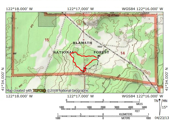
The Pluto Cave Trail departs the trailhead in a westerly direction. Though they rise high in the west, the high peaks of the Klamath Mountains to the west, notably the range’s highest point Mount Eddy, are not particularly conspicuous from this part of the trail. Nature’s omission is compensated by the presence of Mount Shasta towering majestically to the south. The Cascade crest, including the Whaleback, Herd Peak and the Sheep Rock are all visible to the east, but the views are often obscured by tall, gnarled junipers. These peaks are more prominent later in the hike. The trail itself cuts a swath through the classic high desert environment, passing the aforementioned junipers as well as sage and other desert shrubs. The path is wide and at times dusty. A short distance from the trailhead it passes over an interesting rocky stretch. The stone here is rough lava, the layer that is elsewhere omni-present having been worn off or blown away. Still maintaining its westerly course, the trail soon returns to its dusty state. Shortly after this, about 0.25 miles from the trailhead, the path finally arrives at the entrance to the Pluto Cave.

The entrance to Pluto Cave, Siskiyou Mountains in the distance.
The Pluto Cave is a classic lava tube, a tunnel formed by molten lava passing through tubes in older, hardened lava. The cave is only apparent because portions of the roof have collapsed and exposed the subterranean channel. Within the collapsed section, the high desert plants have taken root and the exposed sections of the cave now look like the terrain has simply sunk. However, the yawning caverns opening up in the rocky walls of the sink quickly reveal that this is no ordinary depression in the ground. When the trail finally reaches the edge of the collapsed area, a trail marker indicates the rocky route by which one descends toward the cave’s entrance. As one climbs down into the hole, there is a wide cavern only a few feet away. In addition to the abundant graffiti, one will surely notice the unusual smell. The odor indicates the presence of guano, the calling card of the bat community. This cave only extends about 70 or 80 feet before it is blocked off by a large cave-in. After taking a few minutes to explore the cave, reemerge into the daylight and follow the obvious trail to the north. The rock walls are about 30 feet high and quickly close in towards a natural arch spanning hole. This is, in fact, a section of the lava tube that did not collapse. After passing underneath the arch, the trail continues through more collapsed lava tube before finally arriving at the dark, foreboding entrance to Pluto Cave, the hellish reference seemingly appropriate.

Collapsed ceiling inside Pluto Cave.
The entrance to Pluto Cave is massive, a gaping dark hole leading down beneath the ground. The opening is surprisingly high, probably close to 40 feet, which is further accentuated by the downward angle of the cave. Be sure to bring warm clothes and couple of flashlights. The temperature inside is fairly constant in the upper 40’s whether the outside temperatures are blazing hot are frigid. Also, one beyond the first 0.2 miles of the cave, there is absolutely no light so it is important to not only bring a flashlight but a backup. If one goes dead, the utter darkness inside the cave would make getting out extremely difficult. Once in the cave, the trail makes a mild descent through a large pile of rocks. Though it is possible to make one’s own route through the rocks, there is a rough trail to be followed. As one passes through the craggy pile the drop steepens a bit until the trial finally deposits one on the sandy floor of the cave. Up ahead, a small section of the cave’s rough has caved in, allowing a bright beam of light to illuminate the cave. Here in the light, there is an extensive collection of graffiti. While some of it is more recent in nature, there are prominent markings that were made by explorers earlier in the 20th century. After passing by the opening, be sure to look back. This view is the classic image one typically sees of Pluto’s Cave. From this point, follow the cave a little further to another small caved in section. Instead of just s small section of the ceiling being opened up like the last cave-in, this area is a smaller version of the initial collapse where the trail dropped down into the hole. The small open area is choked with small trees but the trail is obvious. On the far side, the trail once again enters the cave, this time for good. From this point on, there is no light and Pluto Cave extends another mile underground. It is possible to follow the cave to its end. It is a dark and fascinating journey.

Mount Eddy and China Mountain from the lava rampart.
After having explored Pluto Cave, return back to the trail. Rather than going to the trailhead the way one came, there is a nice, though unofficial loop leading back to the parking lot. Look to the north at the trail marker indicating the route down into the cave. One will observe a narrow foot path running along the rim of the collapsed lava tube. Follow this trail north, passing the natural arch. Be sure to climb up onto the arch for a great view of part of the cave and Mount Shasta. Back on the trail, continue north, passing the main entrance to the cave. Though the views along this section of trail are not fantastic, the high desert terrain is attractive. The path soon passes first the small ceiling collapse and then the second, smaller caved in section similar to the one at the entrance of the cave. In both cases one can look down into Pluto Cave. From here the trail maintains a northward heading. Roughly 0.2 miles further, the route arrives at a large, fractured lava uplift. Looping around to the backside of this pile of broken lava, the trail now climbs to the top and follows a narrow cleft in the rock for a couple hundred yards. It seems like one is hiking along the broken rampart of an ancient castle. To the southwest one finally gets a great view of China Mountain and Mount Eddy, giants of the Klamath Mountains. Though tall and standing nearly a mile above the surrounding valley, they are dwarfed by the awesome bulk of lonely Mount Shasta. The view from this lava rampart is the finest on the whole trail. Soon the trail drops off the lava wall and returns to the normal, dusty high desert. It continues only a short distance to the south before ascending a second, smaller lava wall. This section can be hard to miss and is at times marked by rock cairns. After climbing off the second rampart, the trail maintains an easterly heading with views of Herd Peak and Sheep Rock. After another 0.25 miles the trail becomes vague. When this happens head south, towards Mount Shasta for 40 yards or so. This will deposit one on the road within a stone’s throw of the trailhead parking lot, thus completing the Pluto Cave loop.
Directions
From the beginning of Highway 97 in downtown Weed, proceed north on Highway 97 for 12 miles. Turn left onto County Road A12. Continue north on A12 for 3.2 miles. Turn left onto the poorly signed dirt road and proceed to the trailhead. The dirt road is shortly after the well signed turn off for the Juniper Valley OHV area. Metallic letters spelling out “Pluto Cave” are nailed to the telephone pole by the dirt road.

Pingback: Off Season Trails: Winter Hiking In The Shasta Valley | Hike Mt. Shasta
Pingback: Five Trails To Avoid Smokey Skies | Hike Mt. Shasta
Pingback: What did you do to your Cruiser today? - Page 751 - PT Cruiser Forum
Pingback: The Open Road IV | Adventure Awaits
Great place to hike. AllI have is hills here in Central Texas, no mountains. Thanks for stopping by.
I know Texas well. I spent four years in gradschool out there before coming back home to California. My favorite spots in the Hill Country were Garner and Pedernales Falls. However, if you ever get the chance, head up to the Wichita Mountains in Oklahoma. Why they are not more well known is Texas is beyond me, but they are awesome!
Wheelchair Bound into the cave
trying to get to Telos?
I would love to find telos
Pingback: A nice diversion: Trip to Mount Shasta, California | Self Taught Japanese
06/05/17 I and a GF hiked the loop this last Saturday in the late afternoon. The signs to Pluto Cave were hard to see and when we arrived we were the only ones there. Staring out to the left, we took the path through the high desert that led to the gravel road. We followed that road and into the caves enjoying that no one else was there to disturb our experience of the caves. As we were on the path below the trail marker indicating the trail that would take us north to the parking lot, a young couple appeared at the rim and entered the path behind us. As we entered the last of the caves, we went to the right along the cave walls as the couple walked across the center and walked ahead of us. As we ventured forward, ewe could hear them talking from time to time. We noticed that the guy had a flashlight and often waited to help “her” over some rocks by turning the flashlight back towards her. As we got closer to the end of the cave, the walls and ceilings narrowed in and only one path appeared to us as the way forward. Since I had never been there before, I was assuming Pluto Caves was similar to Ape Caves in Washington State with an entrance and an exit.
I was surprised to find that the cave ended in a raised alcove with collapsed rocks to the left of me and above me. There was no air circulation from these areas and clearly the cave passage appeared to end. However, we never saw or heard the couple return back through the cave the way we had to! Is there a way to go all the way through? Is there another path to take on the way out? The couple we saw didn’t seem like they would turn out the lights, or quiet down as we approached them. But we never ran into them or saw them again. It’s very strange bc I’ve done some trails like this in other places but I am certainly no expert. But this mysterious couple seemed to evaporate into the thin cold air of the cave.
The large alcove of rocks you are speaking of is roughly the halfway point. Climb to the top and you will find the opening to the other side. There are no passages or tunnels off the main tunnel.
Pingback: 5 reasons to visit northern California | The Insurance Doctor
Pingback: Shasta Country
Pingback: 25 Amazing Caves in California You Need to Visit