Greetings Robert,
Thank you again for taking this case. Hopefully it can be resolved quickly without a lot of trouble. This email is to give some background on the property and what happened. I will apologize in advance about the profusion of images and maps but I think visualizing things may be helpful.
That said, here is the property in question:
We are the small little shark’s tooth on the bottom. We have three parcels that total about 150 acres. The large property to the north is owned by the state of California, Department of Fish and Wildlife. They have over 6,500 acres. This is all located in the Shasta Valley, which is about 20 minutes north of our home in Mount Shasta. The area is high desert, but is wooded with juniper.
We have long had a strong connection to the Shasta Valley. My wife is a veterinarian and when she used to do large animal work, she spent most of her time working with the cattle ranches out here. In fact, the state land was once the Shasta Big Springs Ranch and she worked with the ranch among many other large ones when it was still a working cattle ranch. When we started looking for land to buy, this was an area we immediately gravitated towards.
The purpose for the land acquisition was varied. Though we have more than a full plate running our animal hospital, we (I mostly) like being hospitable and helping folks enjoy Mount Shasta (we have a house across the street from us that we make available to anyone who wants to stay up here). We though maybe we could build a deluxe campsite for people to stay at on the property, so there was some element of a commercial venture with the property. However, it was primarily a retreat for my family. We loved having a place where we could go to enjoy without interruption. Being adjacent to the state land was also attractive, as it meant that we had access to a vast stretch of what was essentially wilderness that was rarely used. The state owns the land because of the Shasta River, which is the best spawning waters in the entire state for salmon and steelhead runs coming in from the ocean. The surface of the land is basically abandoned, for the most part. We treated our land as a natural preserve adjacent to the state land and tried to keep our impact on it at a minimum.
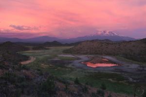
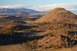
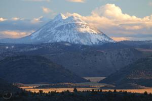
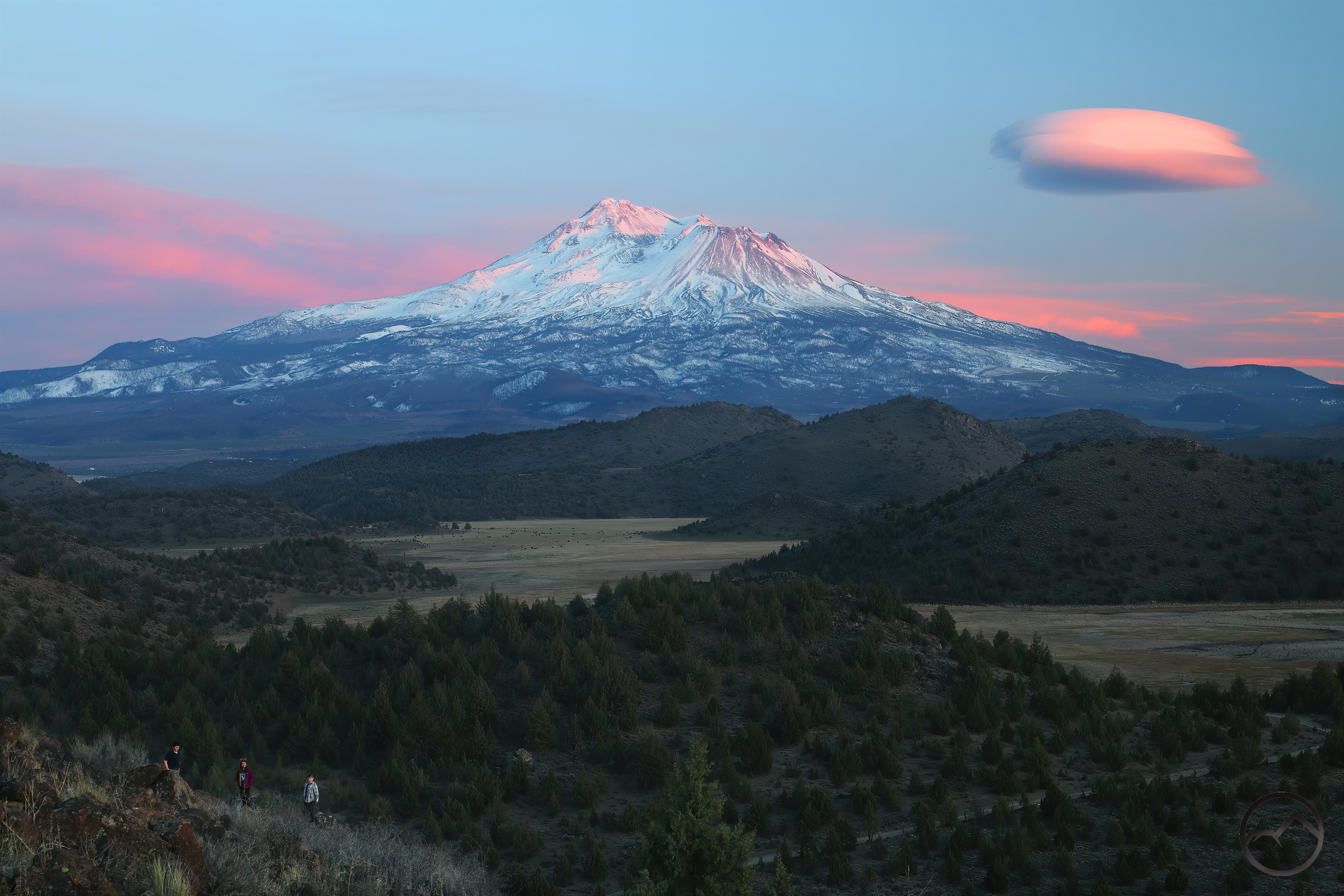
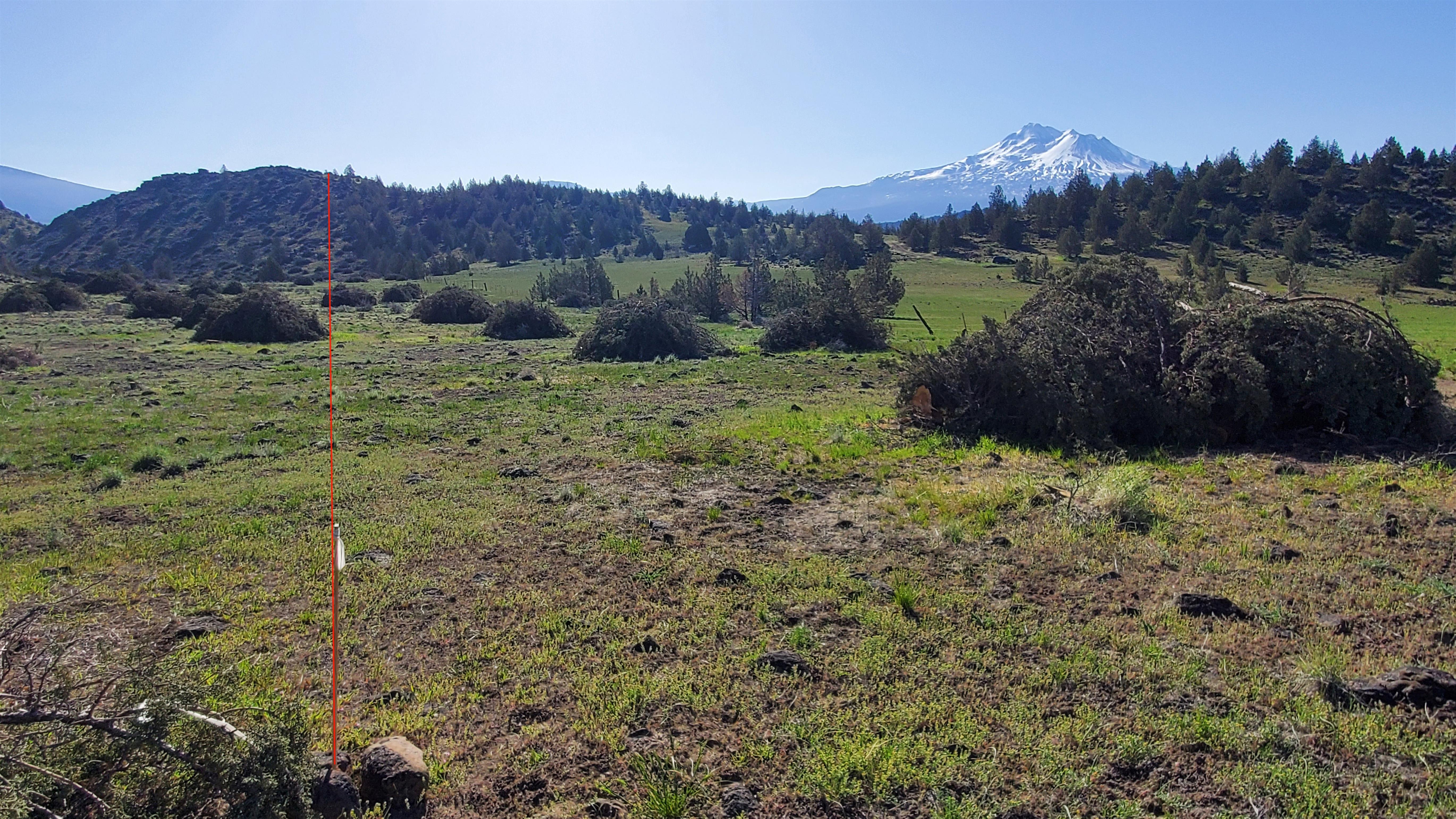
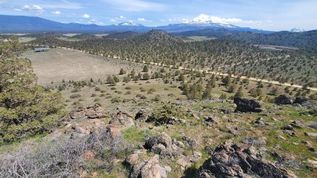
In addition to this, I am an avid photographer (totally amateur, but still a hobby) and the ridge (we dubbed it Truchas Ridge, after the trout and peaks that are a favorite of mine in New Mexico) immediately became one of my favorite places to photograph Mount Shasta and the surrounding area. Here are a few of the kind of shots I like to get from there (click to scroll through larger images):
Of course, there are many, many more of like kind. There is one point in particular that was the location of most of the time spent out there. It is the high point of the ridge, where there are a number of vantage points, which we dubbed Pecos Point, Artist Point, Panorama Point etc. We felt like it was a miniature national park. Here is another shot, this time with my kids:
I can’t say how many sunrises and sunsets I by myself or my entire family have spent out there. It’s a lot. This place has meant a lot to my family.
That brings me to the incident.
My family spent Easter morning out at the Ridge. We actually did an Easter egg hunt there since, after the epic winter, our house in Mount Shasta still had 3 feet of snow on the ground. That was the last time we were at the property before the cutting. A week later I went out there to eat lunch with my kids while driving back to Mount Shasta from our animal hospital (which is in Yreka). As we sat at out picnic tables, we noticed things looked different on the nearby state land. It took a minute to comprehend what the difference was but it finally dawned on me that a bunch of trees had been cut and piled up.
Needless to say I was not pleased, but I reckoned it was state land and they could do what they wanted on their land. I surmised (correctly as I later found out) that it was done to cut in a fire break. It was evident that they had followed the fenceline when cutting, which posed a problem since the fenceline is NOT the property line. The fence is entirely on my property. Consequently, they cut several trees on my land.
NOTE: I have walked this extensively with the surveyor. I know the property lines for certain.
I headed up to Pecos Point (a 0.5 mile hike from our picnic tables) and it was there that I realized the full extent of what had happened. The top of the ridge is bisected by the property line between us and the state. I guessed that they had cut a straight line across the top, just following the “property line”. However, what I found was much worse. They did not follow the property line, they simply clear cut the top of the ridge and cut downhill, on the ridge’s southern exposure which is not anywhere near the property line. This was all our property. Our favorite spot on the ridge had been totally altered.
Furthermore, as I reached the end of the ridge, I looked down the eastern face and found that, not only had they been careless about the actual property line like on the summit of the ridge, here they had actually crossed over the fenceline and cut over 100 feet deep into my property. Not only this, but there were three large junipers that had grown together into one large clump. I had cut all the interior branches of these three trees and created a shaded, hollow space. I had put a picnic table in here, which had a great view of Mount Shasta. This was sort of the eastern hub of our activity at the ridge. These three trees were among the dozens cut in this corner of the property.
I later found out who was responsible at Fish and Wildlife. I spoke with them on the phone and then met with them in person out on the property. They confirmed that this was intended to be a fire break. The state was giving them around $1.4 million in extra funding to cut fire breaks around all 6,500 acres. We discerned that there was a series of mistakes and miscommunications at a few critical points both with Fish and Wildlife as well as with their contractor. They (F&W and the contractor) recognized their culpability in the matter and expressed their desire to “make it right”. That is where the matter has been since talking with them in May.
A variety of factors have stalled resolving this matter. Mostly it has come down to finding legal representation (there is a paucity of attorneys in Siskiyou County) and our own complications in life getting in the way. Now, however, the path is clear to deal with this matter. I do appreciate your help and willingness to take this matter on!
So, here is the extent of what was cut:
The thin white line is our property boundary. The yellow line is the full fire break area cut by the state. The red lines mark the edges of where they cut on our land.
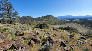
Here is an elevated view of much of the area cut:
This is mostly on state land. It does include the area along the fence line that was cut. It does not include the area where they crossed the fence line.
Here is a recapitulation of what happened in images:
The pin the marks the corner of the property was visible and flagged when they cut it. The red line marks the property line. Note the fence visible between the piles. The piles are not individual trees, but several trees all collected.
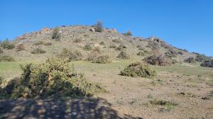
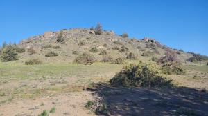
The following are some images showing the now clear cut summit of the ridge. Click on gallery to scroll through larger images.
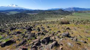
Here is a view down the southern exposure, which is nowhere near the property line. Note the cut trees here too:

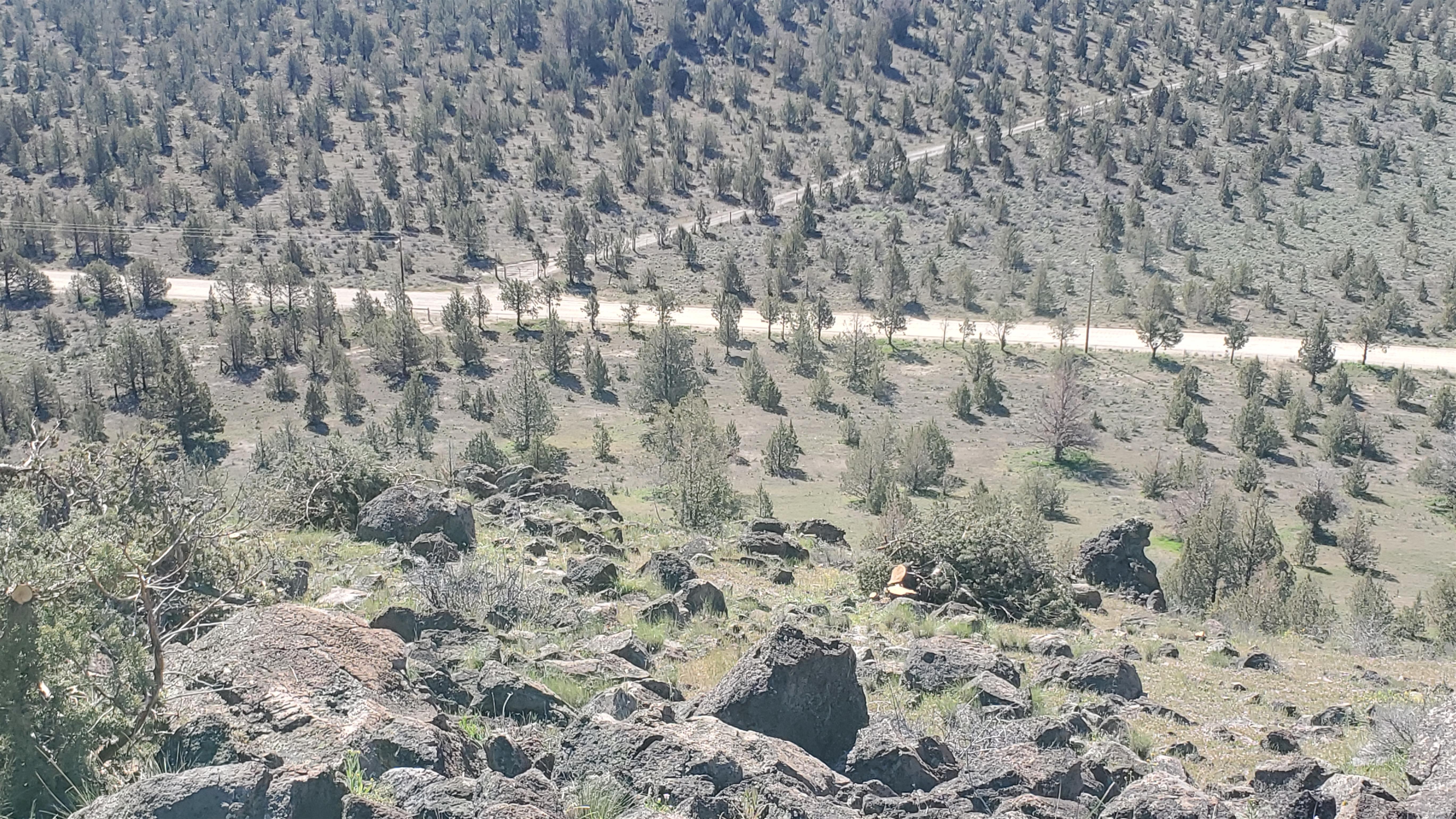
This is the view from the summit of the ridge down the eastern exposure:
Note that they crossed OVER the fence. However, even here, the fence does not accurately represent the property line. It begins at the surveyor’s pin but then runs to a large pile of boulders. From there, an old 19th century rock wall blocks access to cattle. The fence was placed as a matter of convenience, NOT as a reflection of the property line. Consequently, even here if they had just cut from the fence, they would have still been cutting our trees.
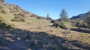
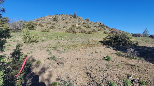
Here are views looking up at the ridge from the lower area they clear cut:
Here you can see the flag they left marking where the edge of the clear cut was supposed to be. Note the trees left standing along the line:
Here is my picnic table:
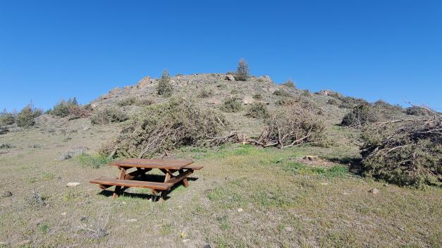
A no point did any sign of use or “habitation” give them pause. They simply cut everything without thinking.
So that should give you an idea of what has happened. We have hardly been out there since this happened. My wife just cries when we have been there.
I recognize that following the fence line was an easy assumption but more care should have gone into the planning and communicating to the contractor. Cutting across the fence though, as well as ambiguous areas like the top of the ridge are not so easily overlooked and were careless and egregious. They materially degraded our property and altered for the duration of our lifetime. We will not live to see it restored.
My wife and I feel like there does need to be some restitution. What that looks like, I am not sure and would really appreciate help determining.
That said, we also recognize that this was a not intentional and we want to be good neighbors. The contractor lives just down the road from our property and we want to maintain amicable relations with him and with the state and its employees who manage the land.
Finding the balance between the maintenance of those relationships but still being recompensed for damages seems like a knife edge that requires careful balance and that is where I am totally uncertain. We aren’t necessarily looking for money, though we aren’t against that either. Some material improvements to the property would also be acceptable or something along those lines. Also, the proper clearing of the debris on our land (and possibly on state land) is a must and non-negotiable as far as we are concerned.
When convenient, I would appreciate discussing this with you!
Thank you again!
Bubba