
I don’t want to steer Hikemtshasta.com too far away from the Northstate, but I want to add an addendum to my post on our recent trip to Yosemite. As noted, Yosemite is a place I have spent a lot of time and hiked many miles. Chief among the trails and scrambles is the Panorama Trail. Of all the places I have hiked in Yosemite and around the country, this trail has consistently ranked as my benchmark hike against which all other trails are measured. As my brother and I have always said, it is on this trail that you get “the most bang for your buck”. The trail is about 8.5 miles long is nearly all downhill, meaning that all of the magnificent sights the trail offers are obtained for a leisurely effort.
What does the Panorama Trail offer? One begins the hike at Glacier Point, which is, in my opinion, the best view anywhere. Once on the trail, it has great views for nearly the entire route. It has constantly changing perspectives on Half Dome and grand visions of the High Sierra. North Dome and the eastern end of Yosemite Valley are companions from afar on the first half of the hike while the descent down the Merced in the latter half offers spectacular yet intimate views of Vernal and Nevada Falls. In the midst of the hike, the trail passes Ililloutte Falls, a fantastic waterfall that is only seen up close on the Panorama Trail (keen observers can spot the falls’ profile on the lower part of the Mist Trail). Panorama Point is also a spectacular vista only accessible on the Panorama Trail. Other highlights along the way include Ililloutte Creek, where the water courses over smooth granite to make refreshing waterslides, the traverse along the top of the Panorama Cliffs, where majestic Yosemite Falls can be seen, and a short detour along the John Muir Trail, which is slung along a sheer cliff and boasts a great vantage to observe Nevada Falls. The hike culminates with a trip down the Mist Trail, a fitting climax to a spectacular trip down into Yosemite Valley.
(click image to enlarge and scroll gallery)
-
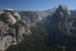
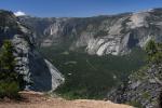
- Before heading out on the Panorama Trail, it is worth stopping and taking in the view from the northern exposure of Glacier Point. Not only does Yosemite Valley lie directly below but you can look east up staggering Tenaya Canyon. While Half Dome and North Dome guard the entrance, Mount Watkind, Clouds Rest and host of high country peaks are seen deeper up the chasm.
-
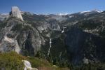
- Heading out from Glacier Point, the Panorama Trail passes below Washburn Point and offers equally terrific views of Half Dome and the Merced River plunging over Vernal and Nevada Falls. High country peaks like Mount Lyell (Yosemite’s highest point) line the horizon as the trail switchbacks down into Illilouette Canyon.
-
- From a vantage across the gorge from the fall, hikers can get a good view of Illilouette Falls and the steep canyon descending down to the Merced. Half Dome is a looming presence from here.
-
- Ilillouette Falls.
-
- Peering into Ilillouette Gorge.
-
- Panorama Point seems to be an often-overlooked perspective on Yosemite Valley. Beyond Glacier Point, Yosemite Falls thunders down to the valley floor. The unique perspective on the Royal Arches and Washington Column, as well as North Dome, give the valley a strikingly different appearance.
-
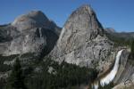
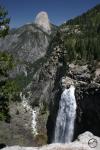
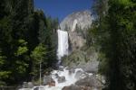
- Once the trail joins the John Muir Trail, it is only a short distance to an awesome bit of trail that features a stupendous views of Nevada Falls racing down a cliff beneath Half Dome, Mount Broderick and Liberty Cap.
-
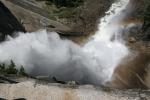
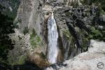
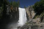
- After finally arriving at the top of Nevada Falls, there is a great opportunity to gaze down the cliff as the waterfall explodes into mist when it hits the end of its plunge. This kind of view makes the waterfall’s “snowy” name seem quite fitting.
-
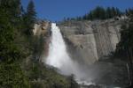
- After descending the cliffs alongside Nevada Falls, there is a good opportunity to look back at the wild torrent. The triangular shape and two-staged nature of the falls give the waterfall an unusual shape. It is hard to believe that a lodge was once located at this spot.
-
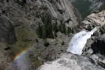
- A classic view of Vernal Fall from the Mist Trail. The trail climbs across slabs of granite that drop steeply down into the river. In wider areas, the cliffs along the area are filled with large boulders and thick grass, watered by the perpetual spray from the powerful falls.
-
- Further down stream from the falls is my favorite vantage point to see Vernal Fall. From here Liberty Cap can be seen rising up behind Vernal. The Merced River makes a torrential passage below the falls, surging over rocks and tumbling over massive rapids. This spot used to be an “official” site, with a trail leading to it an interpretive displays but they were removed some time int he 1990’s.
For those who are ambitious, the Panorama Trail can be combined with the 4-Mile Trail, which climbs out of Yosemite Valley up to Glacier Point. For my money, the combination of these two trails forms the best hike available anywhere. The 4-Mile Trail (it is actually closer to 5 miles), though it climbs over 3,000 feet, reasonably graded and not a difficult hike. It offers sweeping views of the length of Yosemite Valley, from El Capitan, past Yosemite Falls and deep into Tenaya Canyon. The views of Yosemite Falls are particularly grand, as the perspective is constantly changing and the complexity of the three stages of the waterfall is on full display. The climb out of the Valley culminates with the sublime vista from Glacier Point. After a long break taking in the amazing sight, the excitement of the descent back to the Valley awaits on the Panorama Trail.
As I discussed here, I believe that each type of landscape has its own beauty and deserves to be enjoyed on its own merits. Still, every trail I hike, whether in my home area of Mount Shasta or in the Rockies or wherever, inevitably gets compared with the Panorama Trail. After all these years, it remains my benchmark trail (though the trip from Tuolumne Meadows to Waterwheel Falls is a close second, but that is a blog post for the future!).

so beautiful there can’t wait to go someday , i’m not in too much of a hurry i’m in a pretty good spot
I hope you get there someday. Yosemite is worthy of all the positive reputation it has!
yeah I live beside squamish , Bristish Colombia very known rock climbing area same as yosemite so i’m really hoping ot get down there
Spectacular hike. I need to do the combo. next time I’m down there. Thanks.
I hope you are able to soon. It is certainly worth the effort to get down there!
Beautiful area. Would love to hike it. You’re pretty good with a camera!
I hope you make it out there. Words or pictures don’t do it just. You have to hear the roar of the water and feel their power. As far as being good with a camera, I appreciate your saying so but in a place like Yosemite, you just have to point and shoot. God did all the work for us there!
Pingback: Quick Book Update | Hike Mt. Shasta
Pingback: Quick Book Update: Yosemite And The Marble Mountains | Hike Mt. Shasta
Pingback: An Awesome Sight On Black Butte From My Front Yard | Hike Mt. Shasta