Hike Mt. Shasta

Exploring the Mount Shasta Region

  • Home
  • Trails
    • Mount Shasta Trails
      • Brewer Creek Trail
      • Clear Creek Trail
      • Gray Butte Trail
      • Green Butte Ridge Trail
      • Horse Camp Trail
      • North Gate Trail
      • Old Ski Bowl Trail
      • Panther Meadow Trail
      • South Gate/Squaw Meadow Trail
      • Whitney Falls Trail
    • Trinity Divide Trails
      • Blue Divide Trail
      • Castle Lake Trail
      • Castle Lake Shore Trail
      • Cliff Lake Trail
      • Deadfall Lakes Trail
      • Gray Rock Lakes Trail
      • Gumboot Trail
      • Heart Lake Trail
      • Porcupine & Toad Lakes Via Pacific Crest Trail
      • Seven Lakes Basin Via Pacific Crest Trail
      • Sisson-Callahan Trail
      • Soapstone Trail
      • South Mumbo Scramble
      • Tamarack Lake Trail
      • Toad Lake Trail
    • Castle Crags Trails
      • Burstarse Falls Via Pacific Crest Trail
      • Castle Dome Trail
      • Flume Trail
      • Lower Castle Crags Via Pacific Crest Trail
      • Root Creek Trail
    • Scott Mountains Trails
      • Bluff Lake & Cement Bluff via Pacific Crest Trail
      • Caldwell Lakes Trail
      • China Mountain Scramble
      • Cory Peak and Bull Lake via Pacific Crest Trail
    • Cascade Crest
      • Ash Creek Butte Scramble
      • Goosenest Trail
      • Juanita Lake Trail
      • Orr Lake Trail
    • Mount Shasta City Area Trails
      • Black Butte Trail
      • Box Canyon Trail
      • Gateway Trail
      • Lake Siskiyou Trail
      • Mount Shasta City Short Trails
      • Ney Springs Canyon Trail
      • Spring Hill Trail
    • Shasta Valley Trails
      • Black Lava Trail
      • Haystack Trail
      • Lake Shastina Trail
      • Pluto Cave Trail
      • Trout Lake Trail
      • Yellow Butte Trail
    • Sacramento River Trails
      • Dunsmuir Trail
      • Hedge Creek Falls Trail
      • Sacramento River Trail
      • Sims History Trail
    • McCloud River Trails
      • Ash Camp To Ah-Di-Na Via Pacific Crest Trail
      • McCloud River Falls Trail
      • McCloud River Preserve Trail
      • Squaw Valley Creek Trail
      • McCloud River Trail: Algoma Camp to Nitwit Camp
      • McCloud River Trail: Nitwit Camp to Cattle Camp Swimming Hole
      • McCloud River Trail: Cattle Camp Swimming Hole to Camp 4
      • McCloud River Trail: Camp 4 to Upper McCloud Falls
      • McCloud River Trail: Pine Tree Hollow Loop
    • Trails Further Afield
      • Trinity Alps Trails
        • Bear Lakes Trail
        • Billys Peak Trail
        • Boulder Creek Lakes Trail
        • Boulder Lake Trail
        • Canyon Creek Trail
        • Caribou Lakes Trail
        • East Boulder Lake Loop
        • East Weaver Lake Trail
        • Four Lakes Loop
        • Granite Peak Trail
        • Grizzly Creek Trail
        • Gulch Lakes Loop
        • Hidden Lake Trail
        • South Fork Lakes Trail
        • Stoddard Lake Trail
        • Stoney Ridge Trail
        • Tangle Blue Lake Trail
      • Warner Mountains
        • Emerson Creek Trail
        • Highgrade Trail
        • Patterson Lake Via Warner Summit Trail
        • Pine Creek Trail
        • Squaw Peak Trail
  • Articles
    • Trails By Area
      • Mount Shasta
        • Vistas, Meadows And Waterfalls: Three Best Hikes On Mount Shasta
        • The End Of The Road: Three Hikes In The Old Ski Bowl Area
        • Two Trails From Bunny Flat
        • Three Trails On Mount Shasta’s East Side
        • Mount Shasta’s Hummingbirds
      • Trinity Divide
        • Great Lakes: Top Five Lake Basins In The Trinity Divide
        • The Headwaters Of The South Fork Of The Sacramento River
        • Neglected Headwaters: Two Lesser Lake Basins On The South Fork
        • Gumboot Saddle: Two Hikes On The PCT
        • Descent Into Mystery: The Sisson-Callahan Trail
        • Mumbo Basin – Overlooked On The West Side
        • The Headwaters Loop: A Proposed Backpacking Loop In The Trinity Divide
      • The McCloud River
        • The McCloud River Trail
      • Shasta Valley
        • Jewels In The Desert
      • Scott Mountains
        • Great Scott! Two Scott Mountains Hikes On The PCT
      • Trinity Alps
        • Carubou Lakes: Trinity Alps On A Grand Scale
        • Switchbacks To Heaven: The Trinity Alps’ Stoney Ridge Trail and Four Lakes Loop
        • Trinities In Proximity: Two Trinity Alps Trails With Easy Access From Mount Shasta
        • Trails in the Carter Meadows Area
        • Trinity Alps Views of Mount Shasta
        • The Psychological Value Of The Trinity Alps
    • Waterfalls
      • Three Waterfalls On Mount Shasta
      • McCloud River Waterfalls
      • Sacramento River Waterfalls
      • Trinity Divide Waterfalls
      • Trinity Alps Waterfalls
      • Avoiding A Dry Whitney Falls
    • Off Season Trails
      • Three Winter Hikes Near Mount Shasta City
      • Winter Hikes In Shasta Valley
      • Winter Hiking In The Shasta Valley Wildlife Refuge
      • Winter Hikes On The Sacramento River
      • Winter Hikes On The Lake Siskiyou Trail
      • Spring Hikes In The Castle Crags
      • Spring Hikes On the Upper McCloud
      • Spring Hikes On The Lower McCloud River
    • Points Of Interest
      • Mount Eddy: Overshadowed, Underrated
      • Black Butte: Hiding In Plain Sight
      • Castle Dome: Steadfast And Staggering
      • Mount Shasta Hoodoos
      • Sacramento Scrambling
      • The Shasta River
      • The Castle Creek Watershed
      • Mount Shasta East Side Glacier View
      • 5 Fantastic Mount Shasta Vistas
      • 5 Highest Peaks Around Mount Shasta
      • 5 Best Hikes On Creeks And Rivers
      • 5 Interesting Footbridges
      • Three Spectacular Drive-To Sunset Vistas
    • North State Geography
      • Introduction
      • Seven Major Regions
      • The California Cascades
      • Klamath Mountains Pt. I
      • Klamath Mountains Pt. II
      • The Great Canyons Of Mount Shasta
      • Mount Shasta, Timberline, And The Relative Size Of Cascade Volcanos
      • Four Eruption Cones Of Mount Shasta
      • Mount Shasta’s Medial Moraine
    • Northern California Review
      • North Table Mountain
      • Lakes Basin Recreation Area
      • Eastern Sierra Fall Color
      • Sonoma County
      • Central Sierra Nevada
      • Orland Buttes
    • Seldom Seen
      • Ash Creek Falls
      • Mud Creek Canyon
      • Lower Mud Creek Canyon
      • Diller Canyon
      • Lower Cascade Gulch
      • The Grey Rocks
      • Castle Creek
      • Upper Wagon Creek
      • Fawn Creek Canyon
      • Confluence of the Sacramento River and Castle Creek
      • Upper Klamath River Canyon
      • Hole In The Ground Geologic Area
      • Ash Creek Butte Fossil Rock Glacier
    • Mount Shasta History
      • Vantage Lost: The Everitt Memorial Vista
      • A Yosemite-Mount Shasta Connection
      • Whitney – What’s In A Name?
      • Mount Shasta Area and the 1838 Exploring Expedition
      • A 19th Century Engraving Of An Epic Mount Shasta Vista
      • Vintage 1907 Color Photos
      • A Misleading Painting
      • A Mysterious Painting
      • A Mysterious Painting Pt. II
      • Stereographic Mt. Shasta
      • Year One Of Hike Mt Shasta
      • Year Two Of Hike Mt Shasta
      • Year Three Of Hike Mt Shasta
      • Year Four Of Hike Mt Shasta
      • Year Five Of Hike Mt Shasta
      • Year Six Of Hike Mt Shasta
      • Year Seven Of Hike Mt Shasta
    • Image Galleries
      • Mount Shasta Trails Gallery
      • Mount Shasta Sunrise Gallery
      • Mount Shasta Sunset Gallery
      • Lenticular Cloud Gallery
      • Mount Shasta NON-Lenticular Clouds
      • Mount Shasta Reflection Gallery
      • Telephoto Gallery
      • Mount Shasta Area Fall Color
      • Castle Crags Gallery
      • Waterfalls Gallery
      • Trinity Divide Lakes Gallery
      • Mount Shasta Area Rivers Gallery
      • Shasta High Desert Gallery
      • Mount Shasta GIF Gallery
    • Random Notes
      • Revew: Three Mount Shasta Trail Maps
      • A Mount Eddy Wilderness?
      • New Land Additions For The Castle Crags
      • Book Plug: Mount Shasta Area Rock Climbing
      • Exile: How I Came To Love Wilderness
  • Mt. Shasta Trail Map
  • Blog
  • About/Contact
  • Links
  • Truchas Ridge

The Final Sunrise And Sunset Of 2020 (And A Few Other Things From The Last Week Around Mount Shasta)

Posted by bubbasuess on December 31, 2020
Posted in: Cascade Range, Hiking, Mount Shasta. 4 Comments

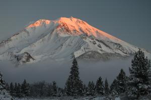
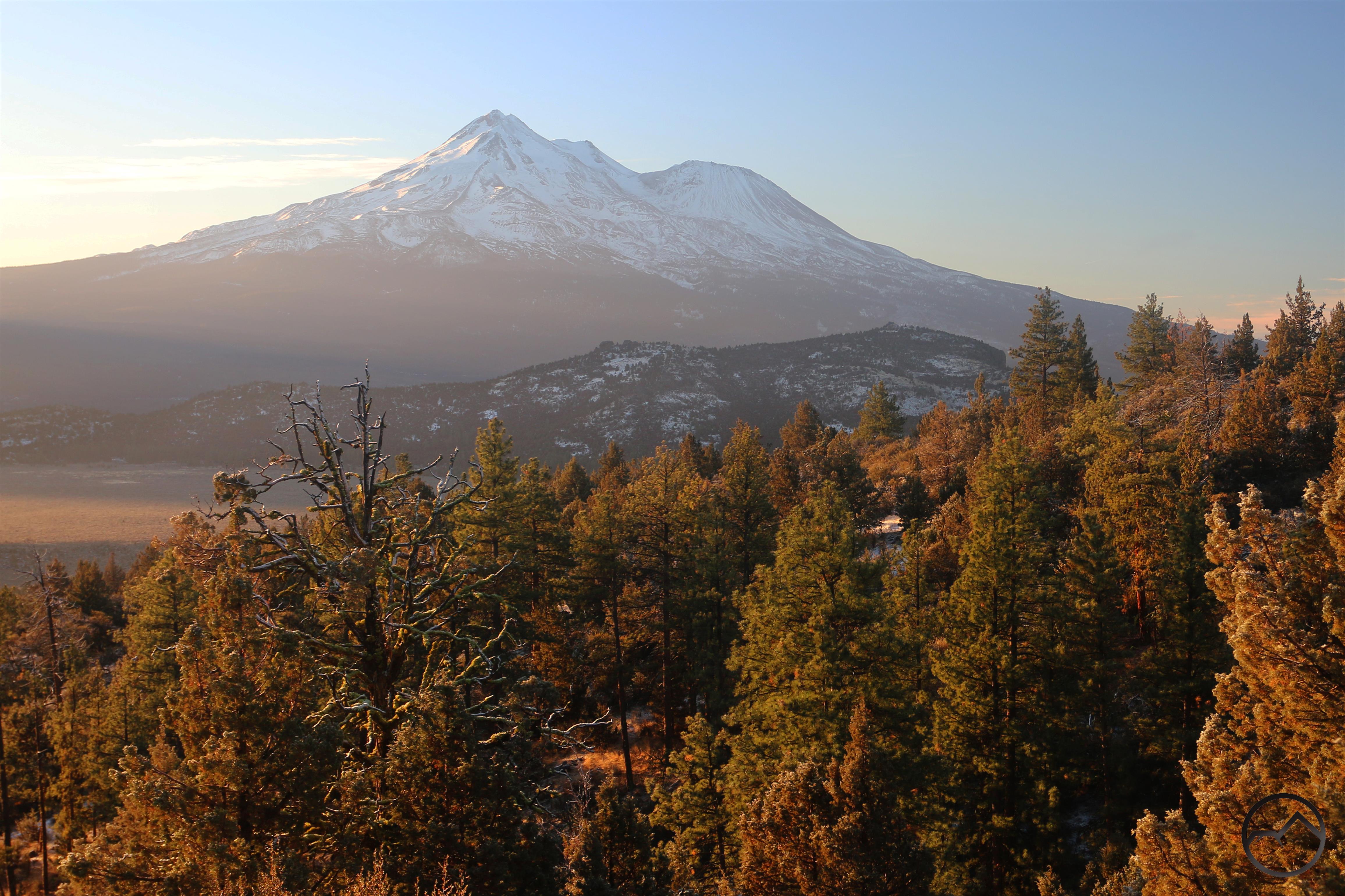
It’s New Year’s Eve and 2020 is finally coming to an end. The year ended quietly in the Hike Mt Shasta household, with snowshoeing, skiing, much merry making and lots of sunrise and sunset chasing. It has been a beautiful week since Christmas and I was able to get out on multiple occasions to imbibe the beauty. It ended with a fresh layer of snow and a beautiful sunrise and sunset. While the year was crazy in so many ways for so many people, it is satisfying to finish it quietly watching the color fade from the snow flanks of Mount Shasta. That said, I would like to review a few images from the week:

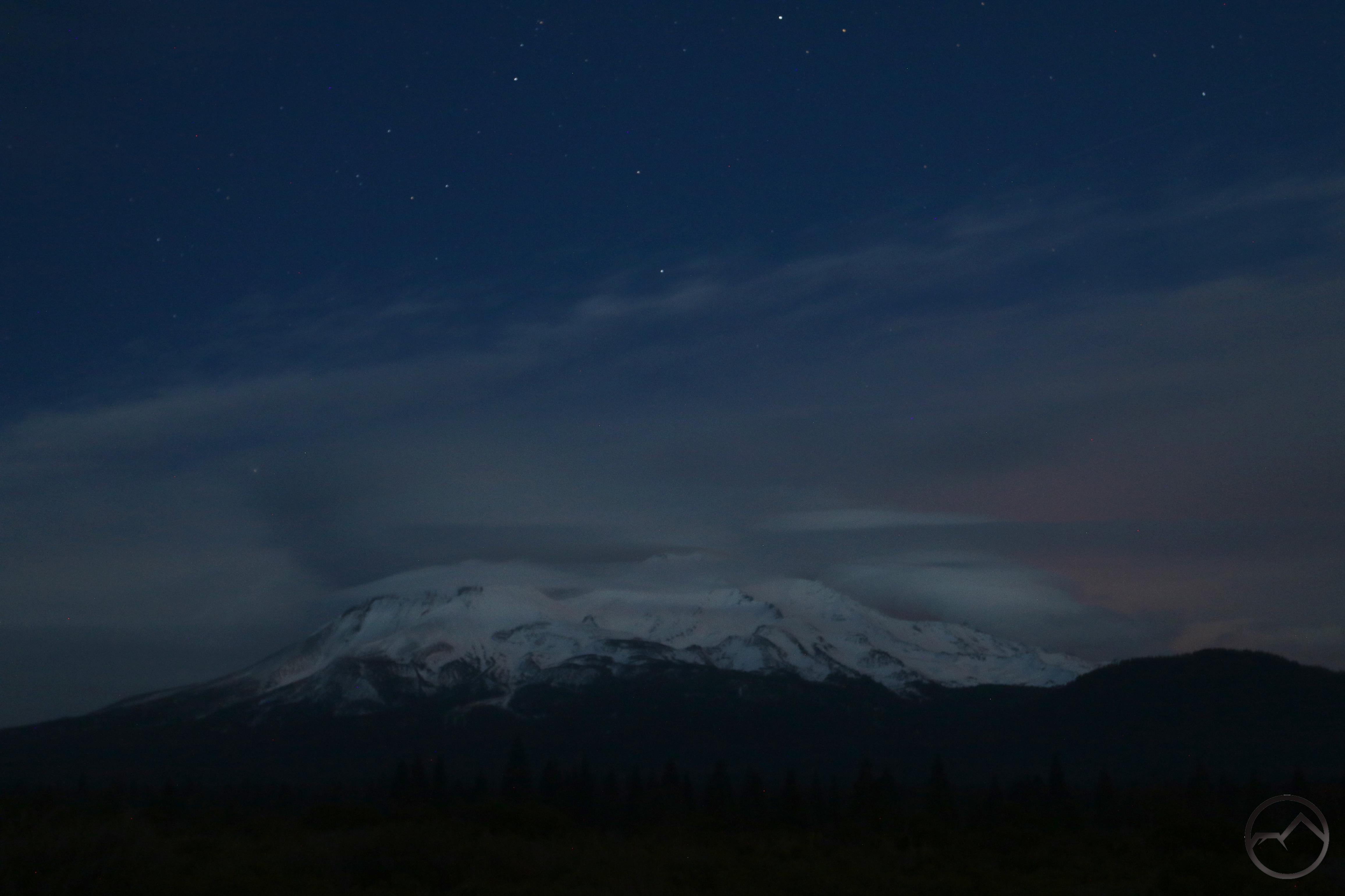
The moon has been rising in the vicinity of Mount Shasta. I never seemed to be able to time its breaking the horizon with my being in a position to photograph it but I did enjoy views of the mountain in near proximity. The warm light of sunset contrasting against the silvery moon is always a glorious sight.

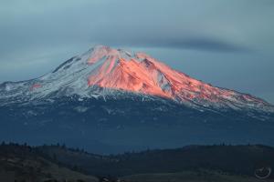
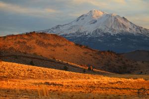
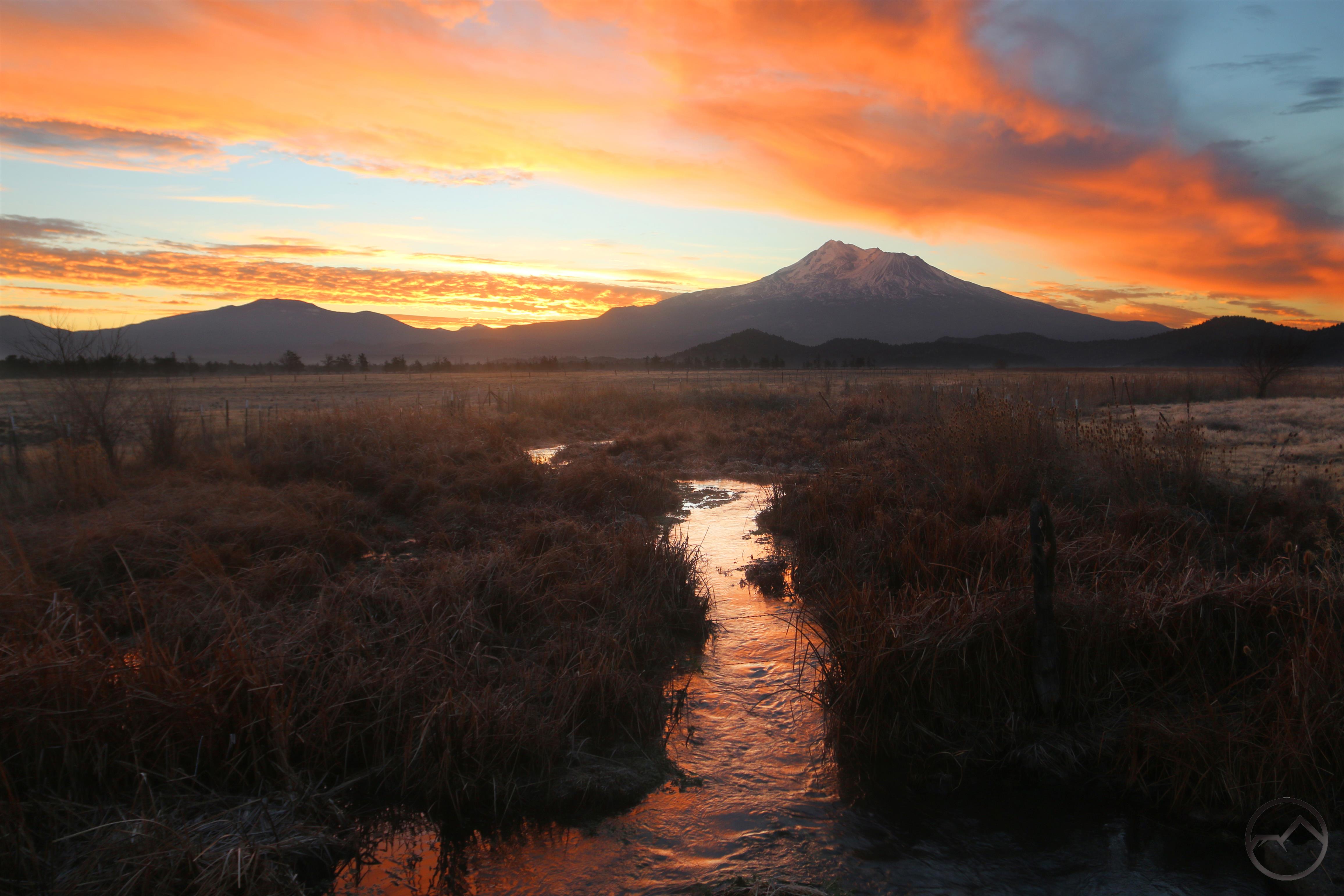
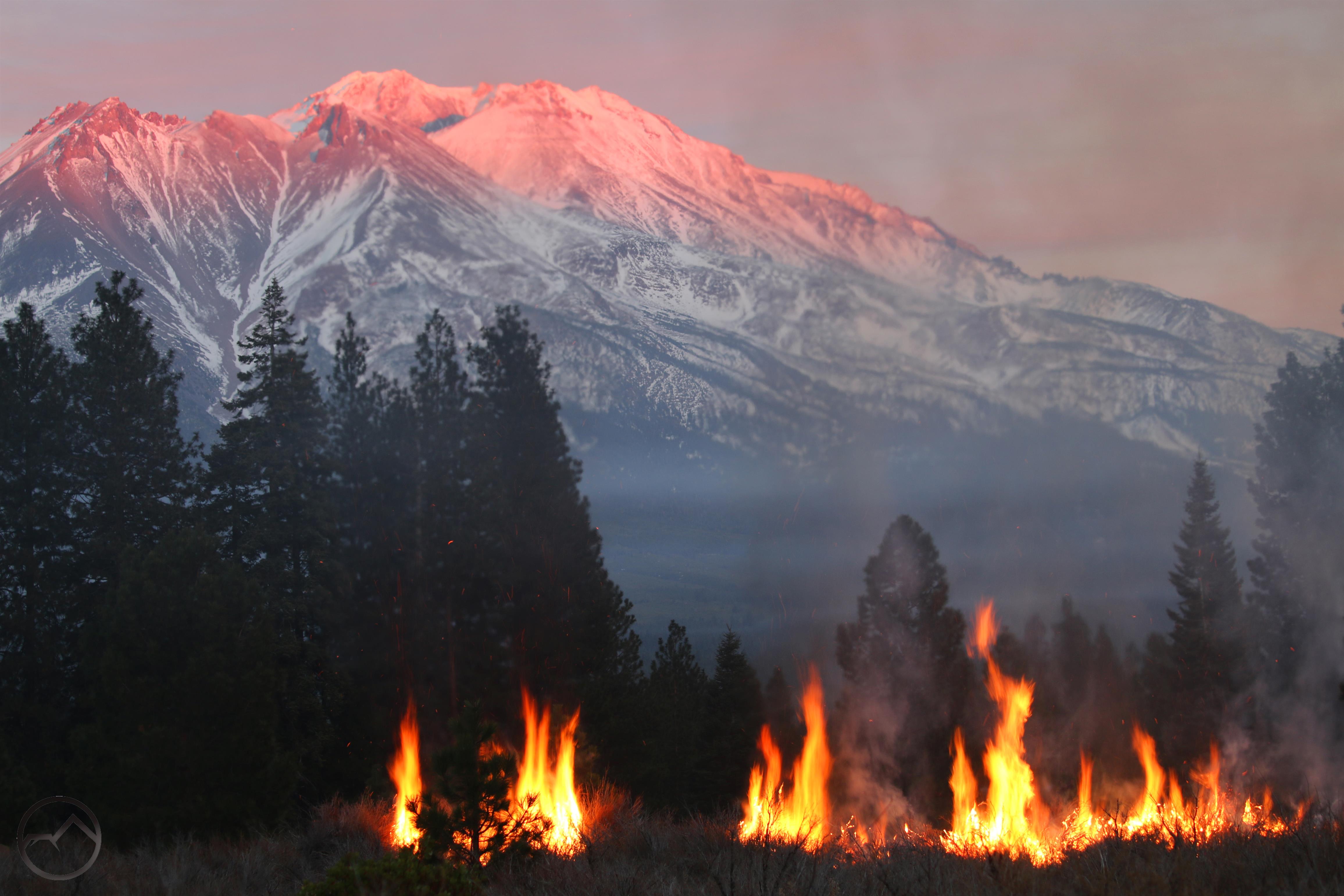
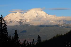
I went out to the Shasta Valley on Tuesday to capture the sunset and while the color built up in the sky around Mount Shasta, I found my eyes drawn to the massive fires building up on Willow Creek Mountain. Though plumes marked the locations of the fires, the dancing flames were visible to the naked eye. Through my telephoto lens, they looked fearsome, especially after the year of the inferno that was 2020. Fortunately these were controlled fires burning slash. It is still disconcerting to see from afar.
In spite of the flames, I still managed to look at the mountain around me:

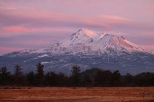
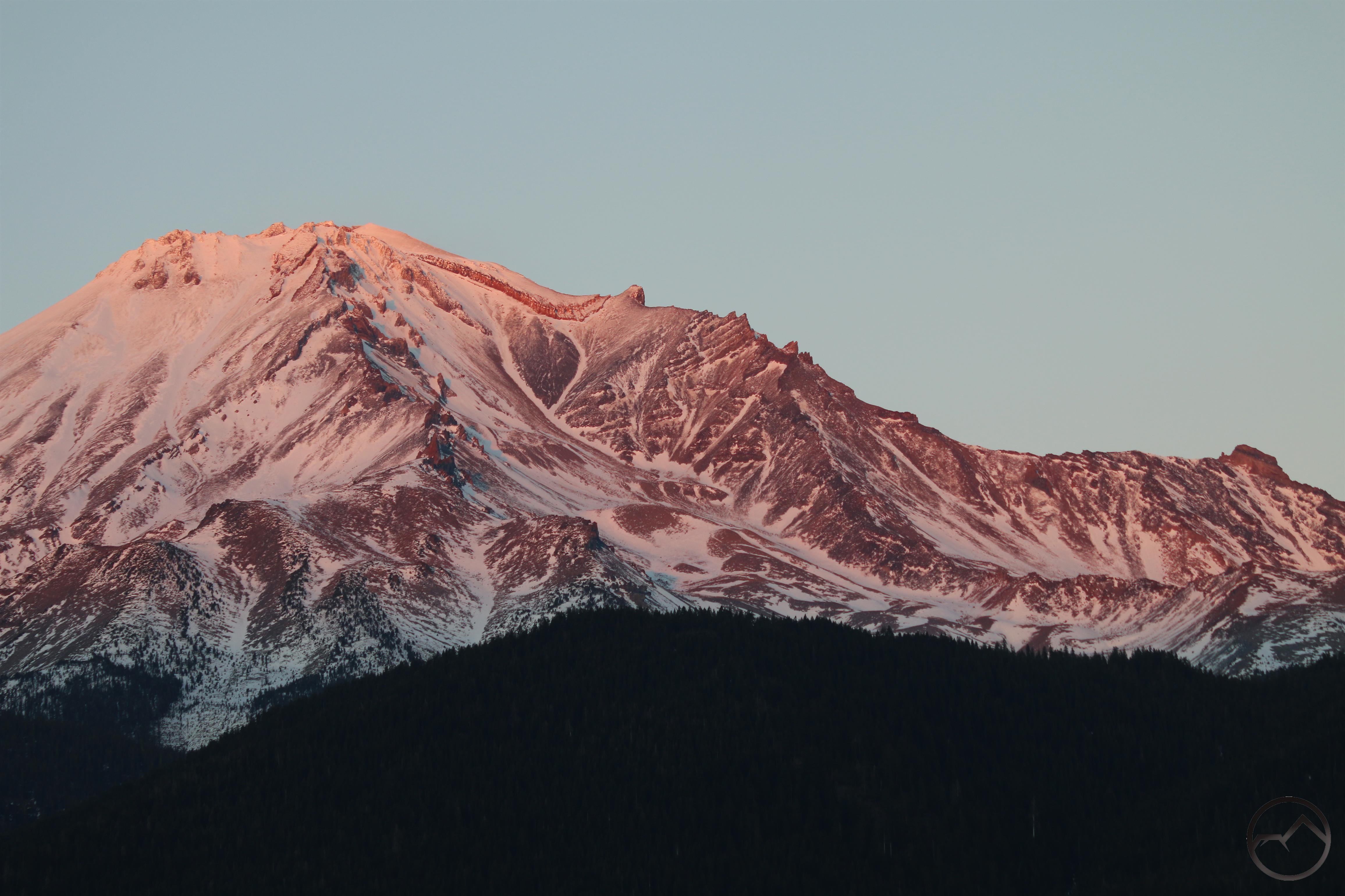
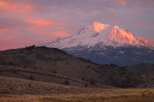
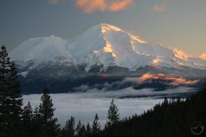
Mount Shasta glows in the fading light of sunset.
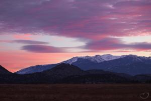
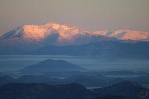
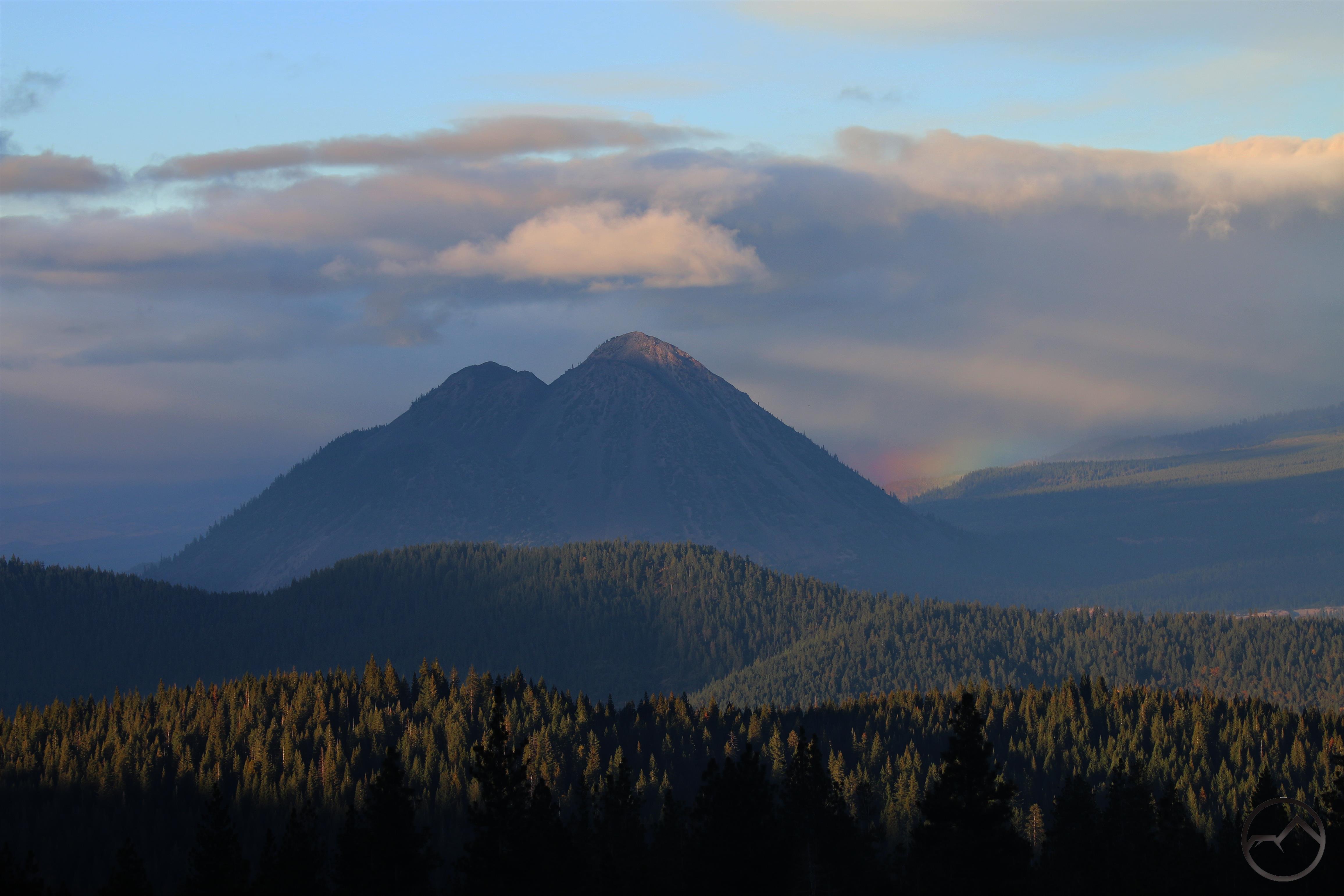
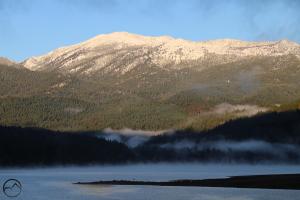
Alpenglow lights of Mount Eddy and the surround clouds.

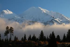
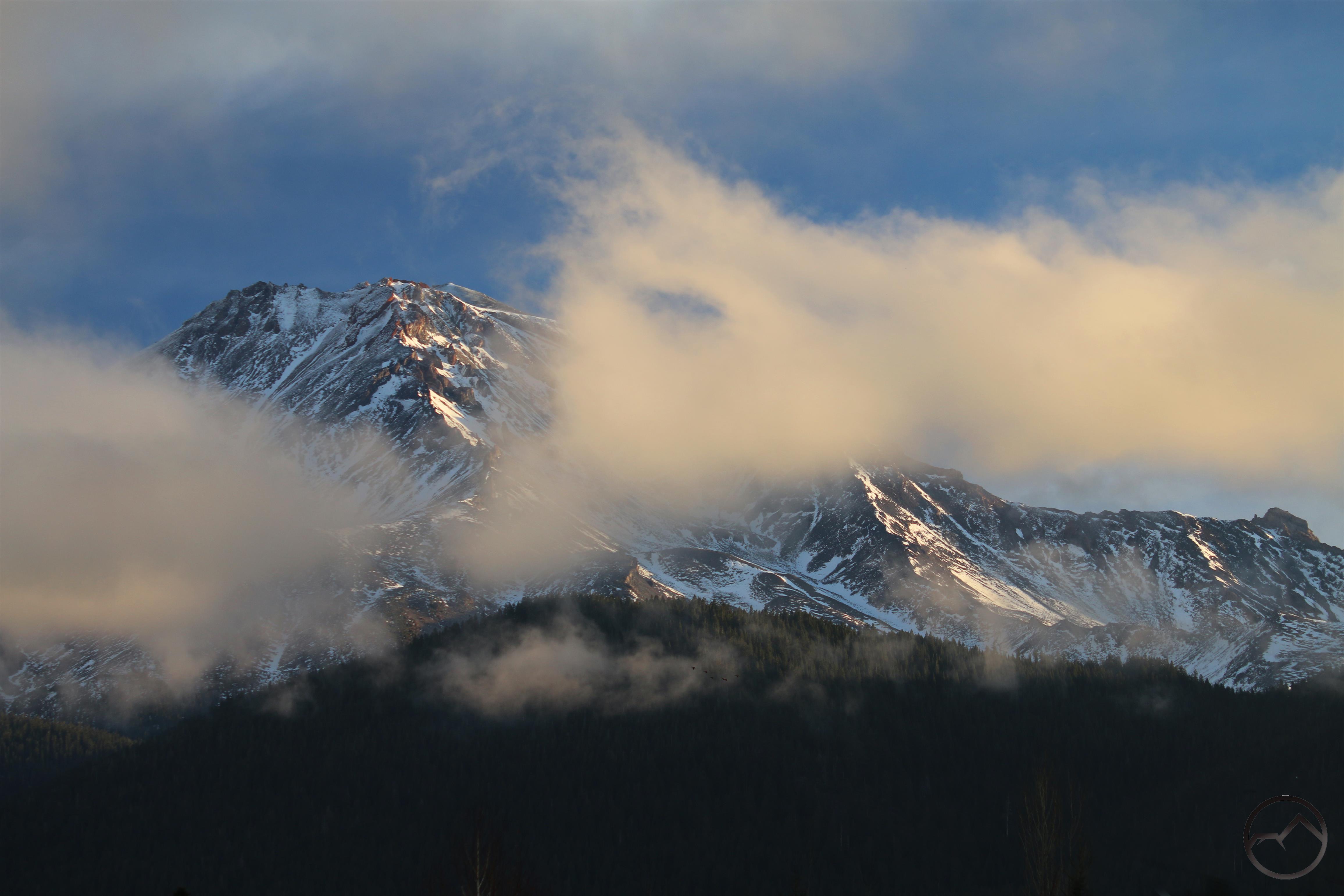
The light on Mount Shasta was not great but the glow over the entire Shasta Valley was beautiful and eerie. I love the winter view of the mountains on all sides of the valley, crowned by the snowy majesty of Mount Shasta.

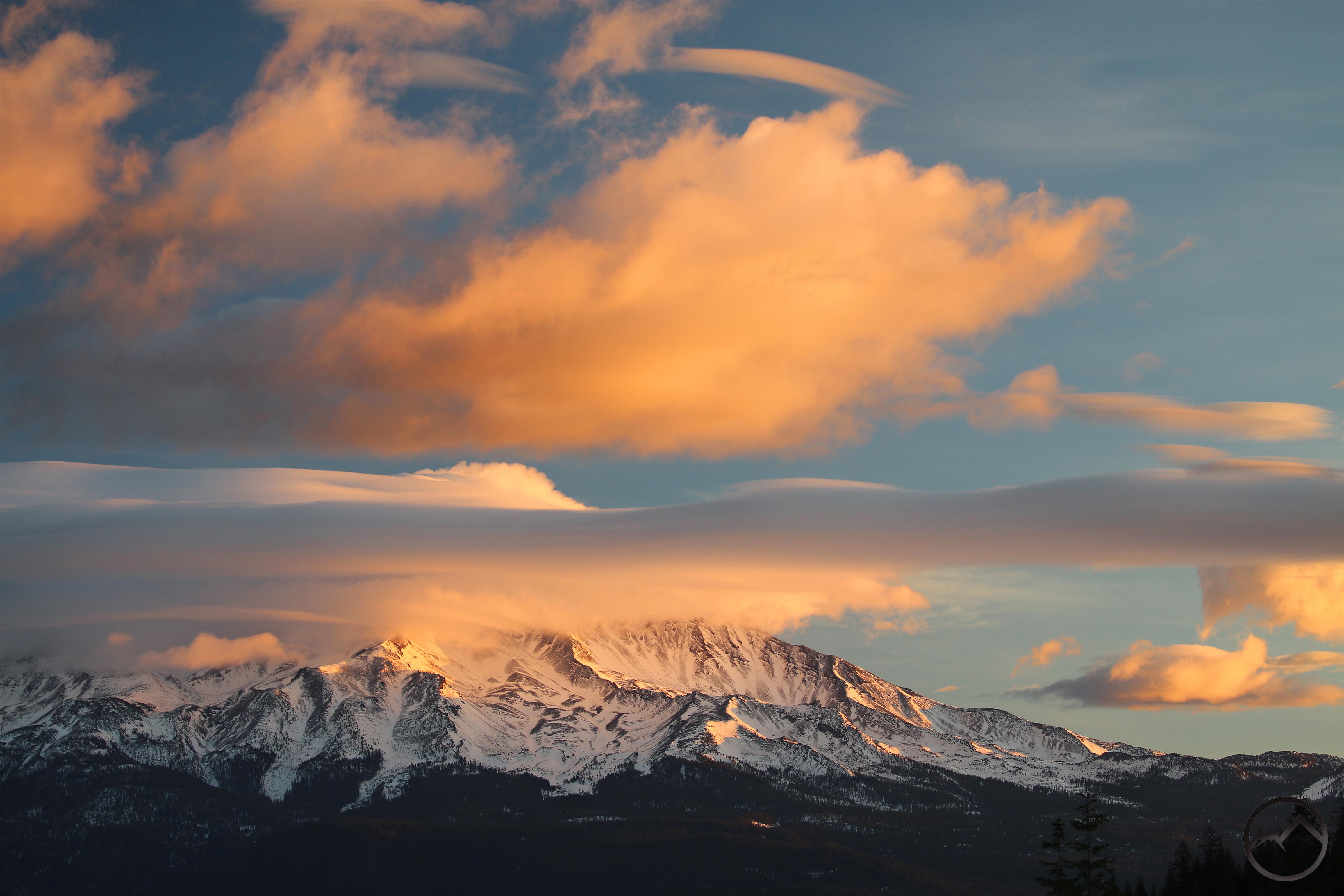
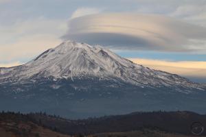
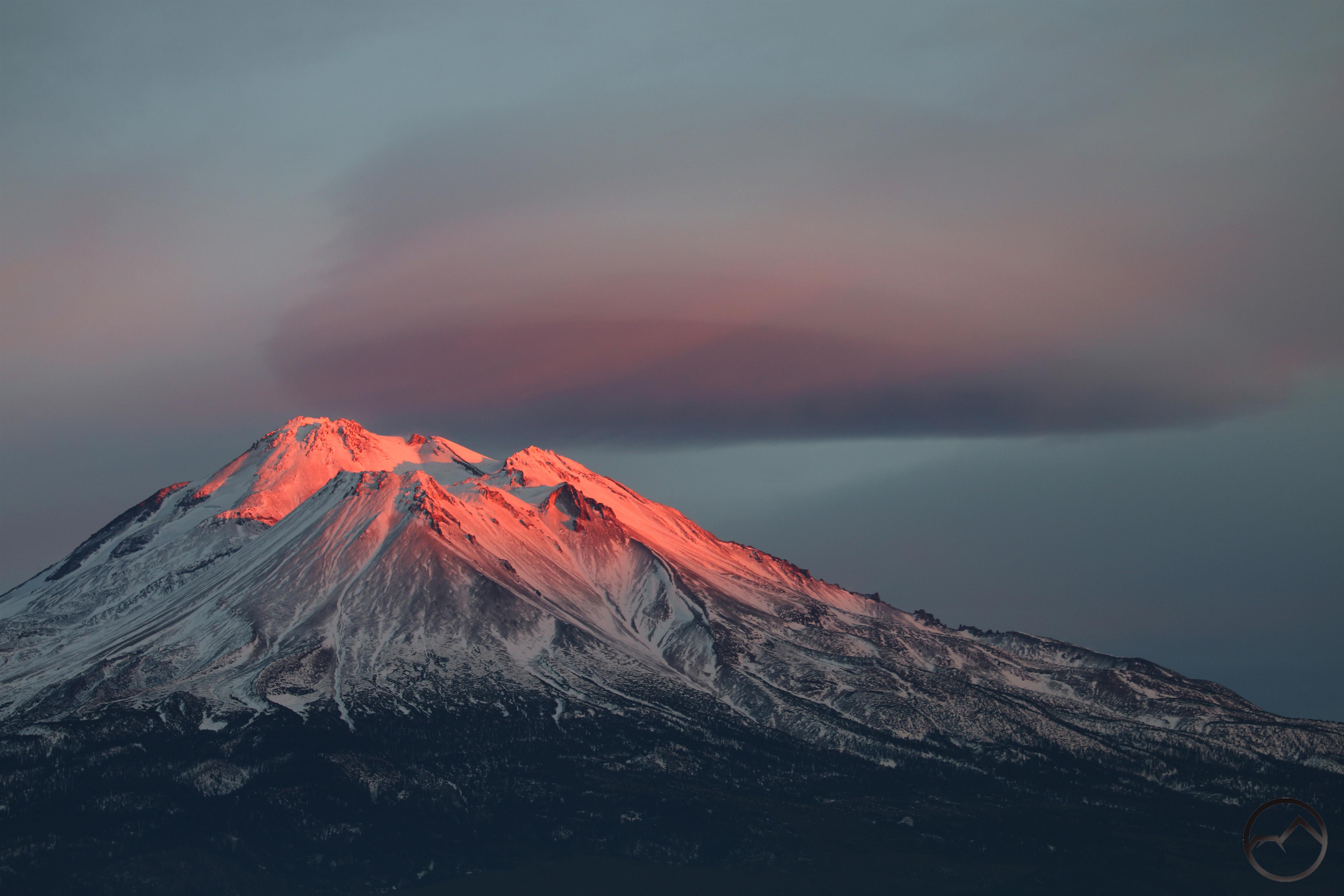
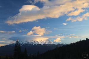
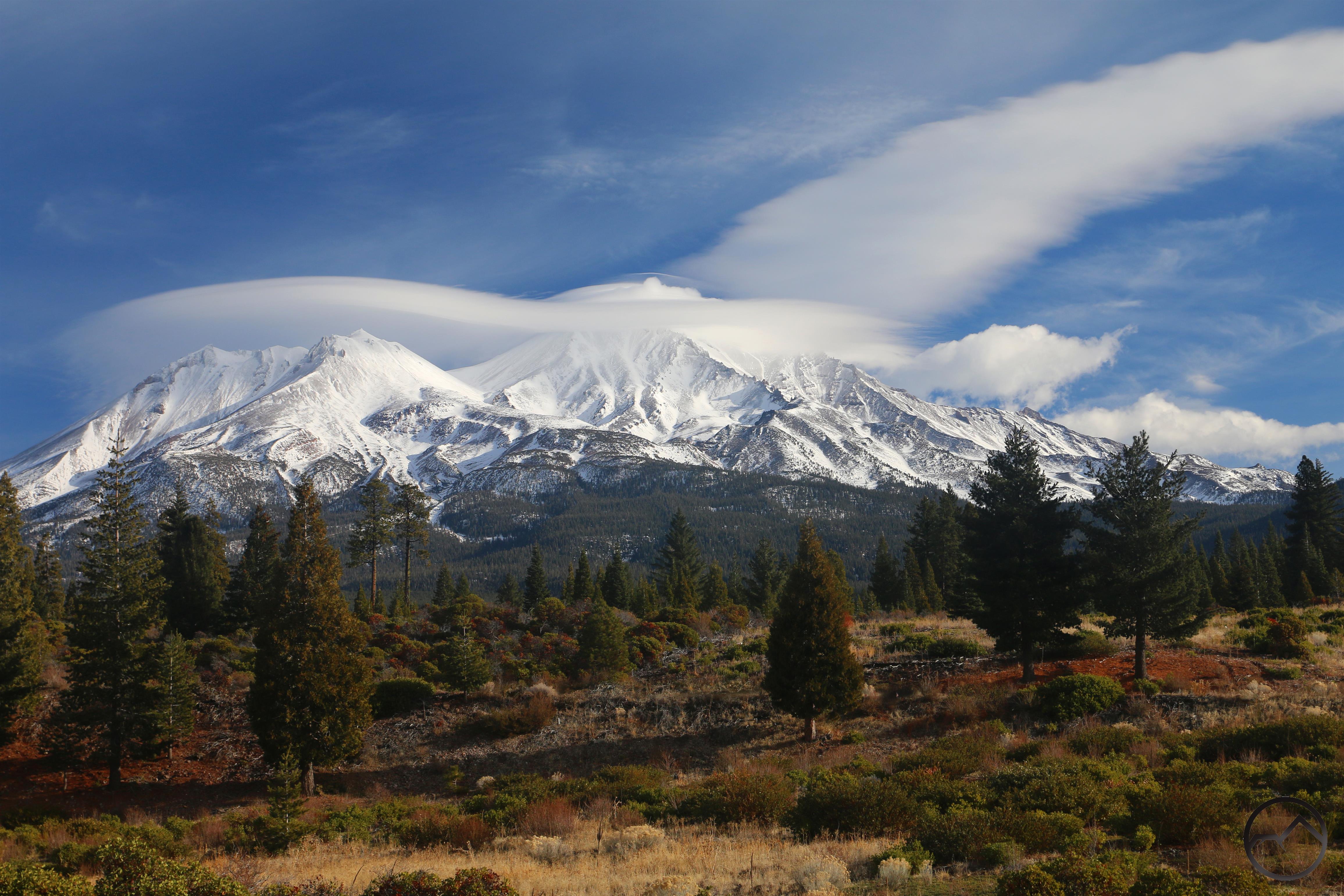
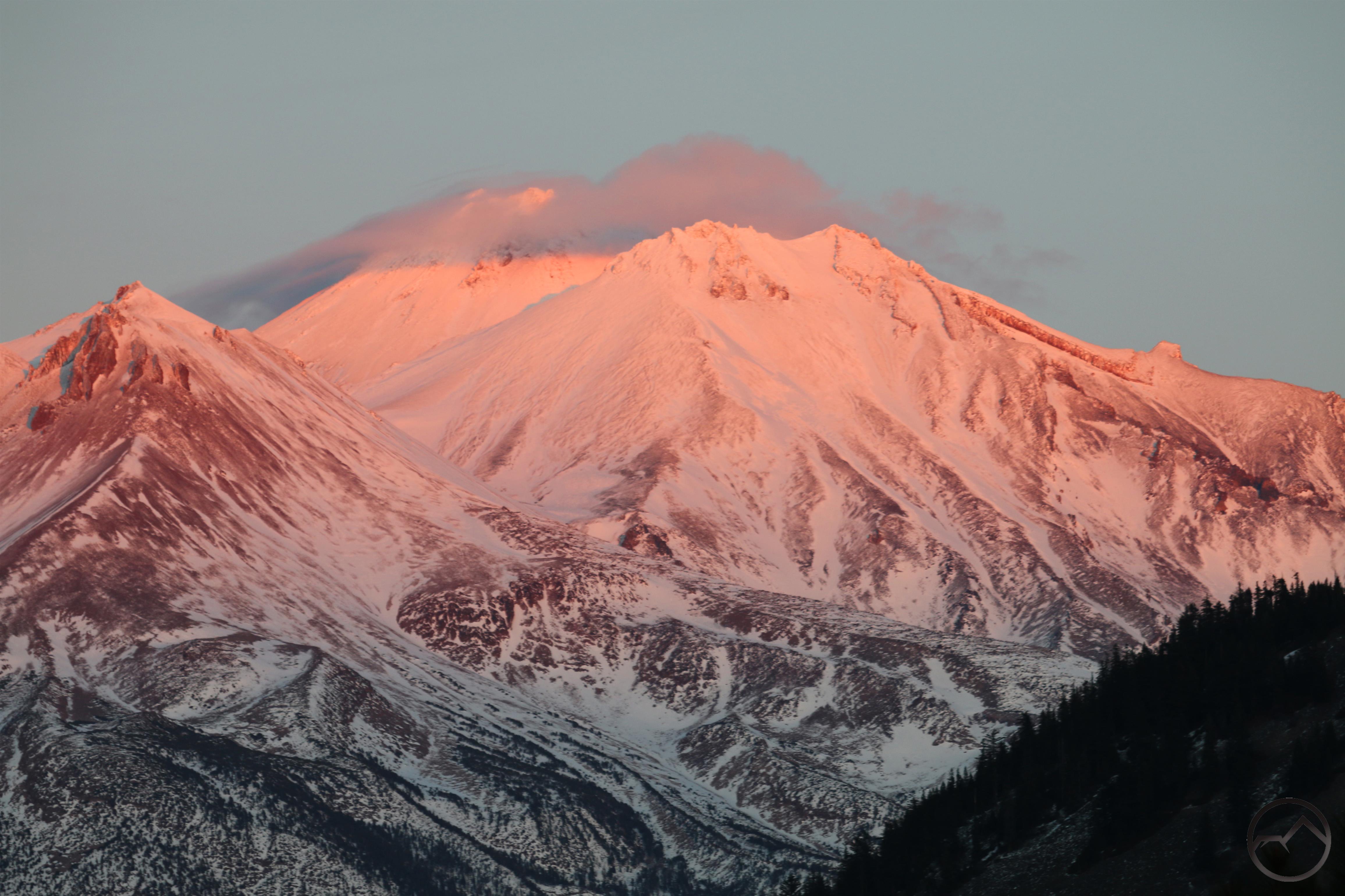
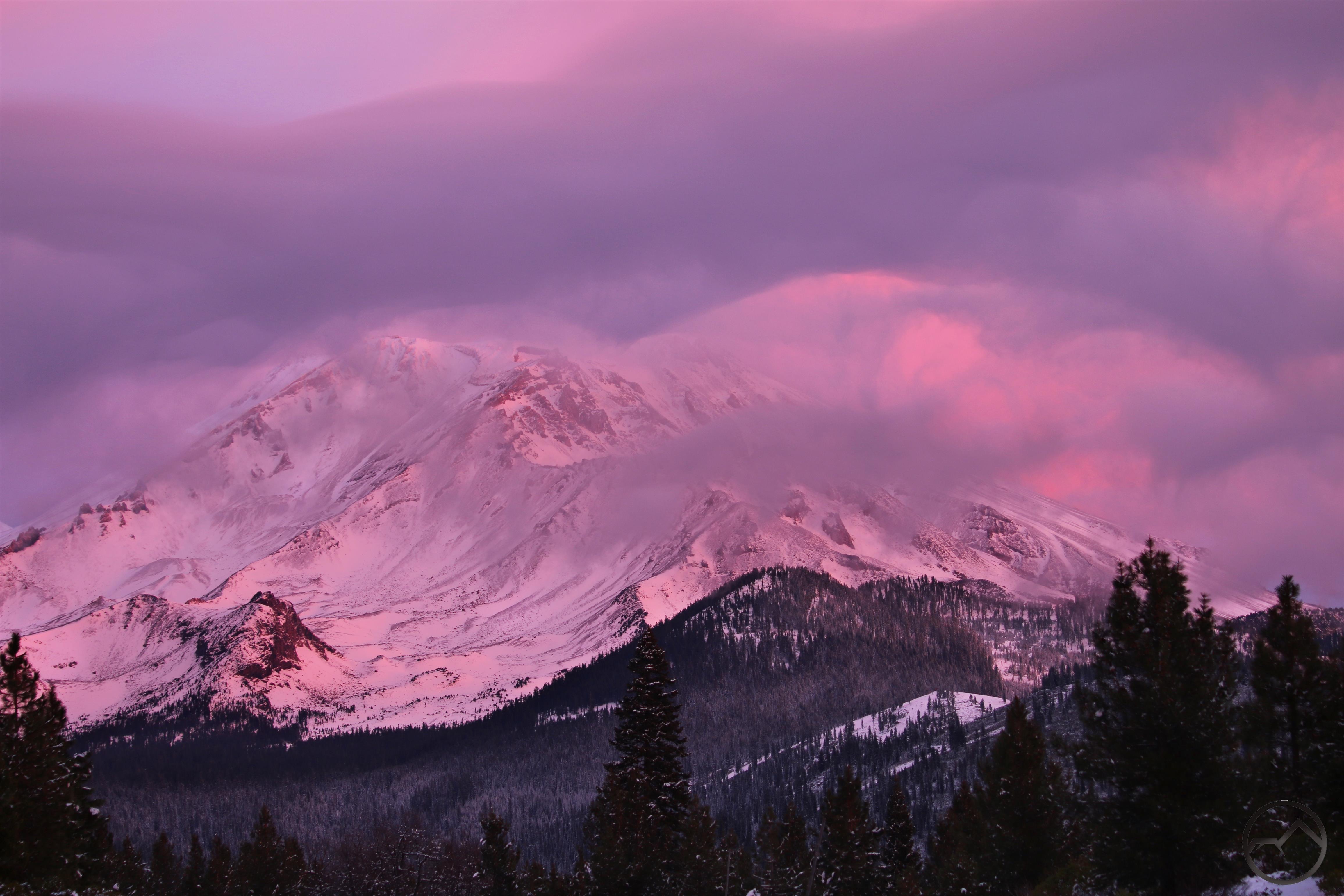
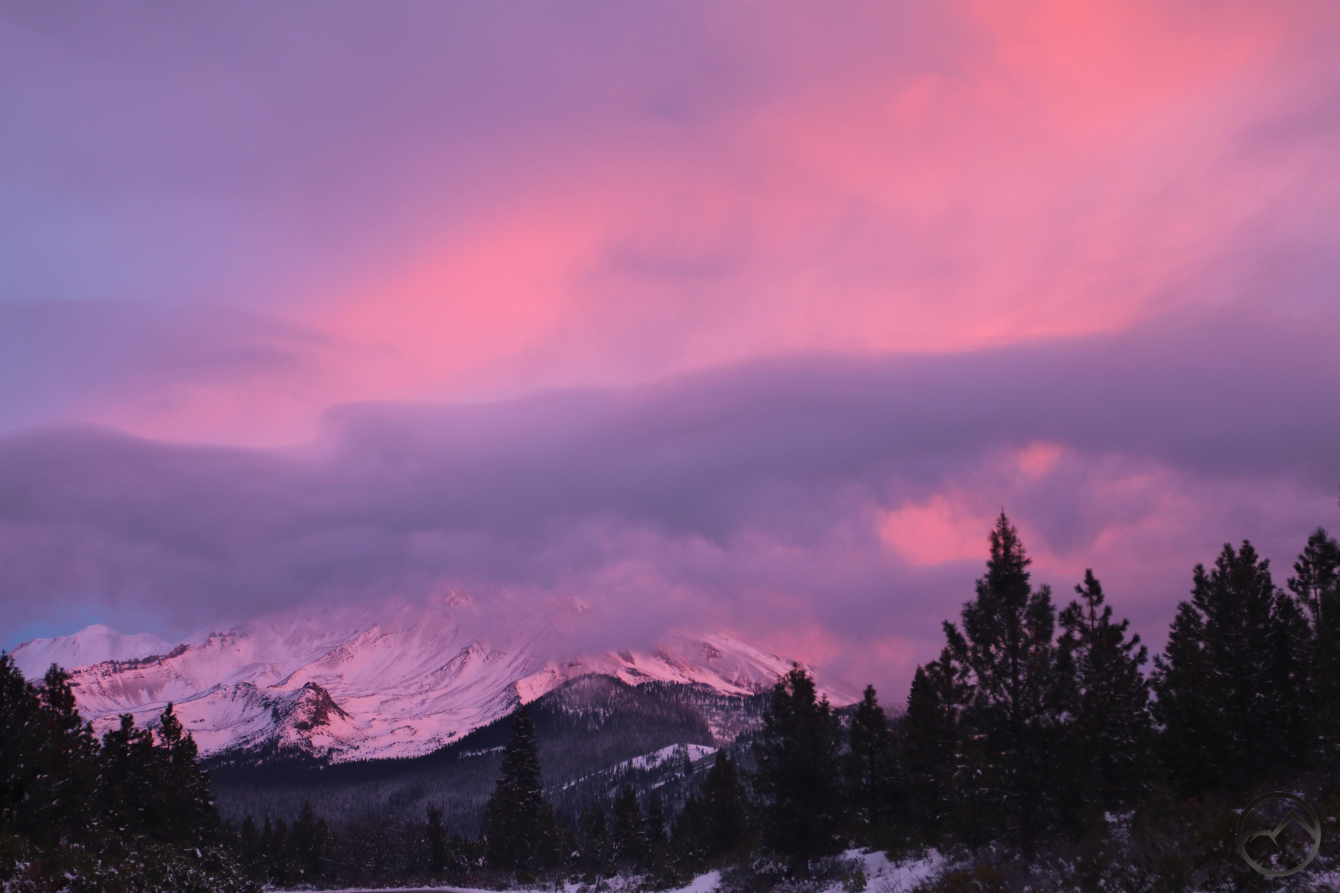
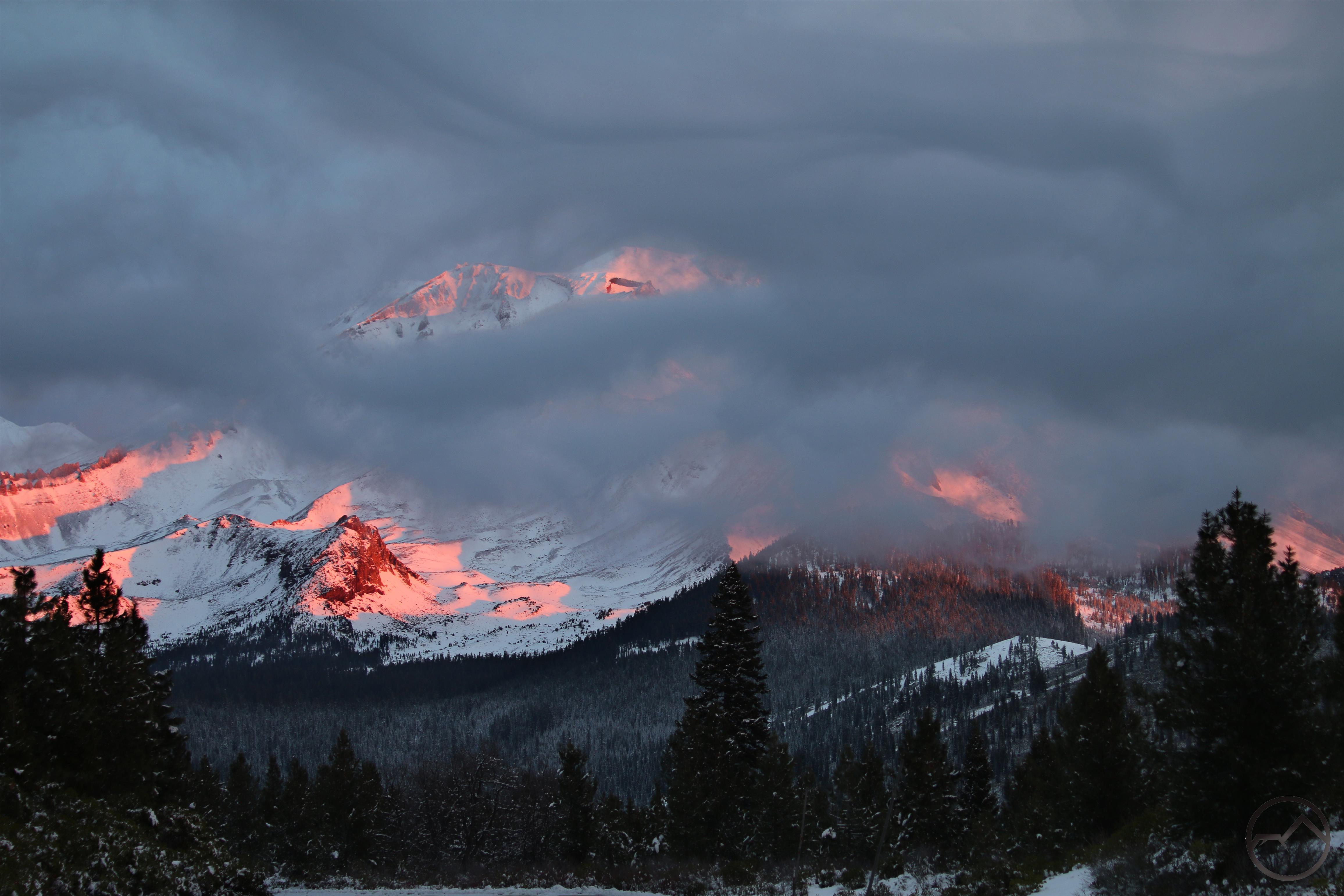
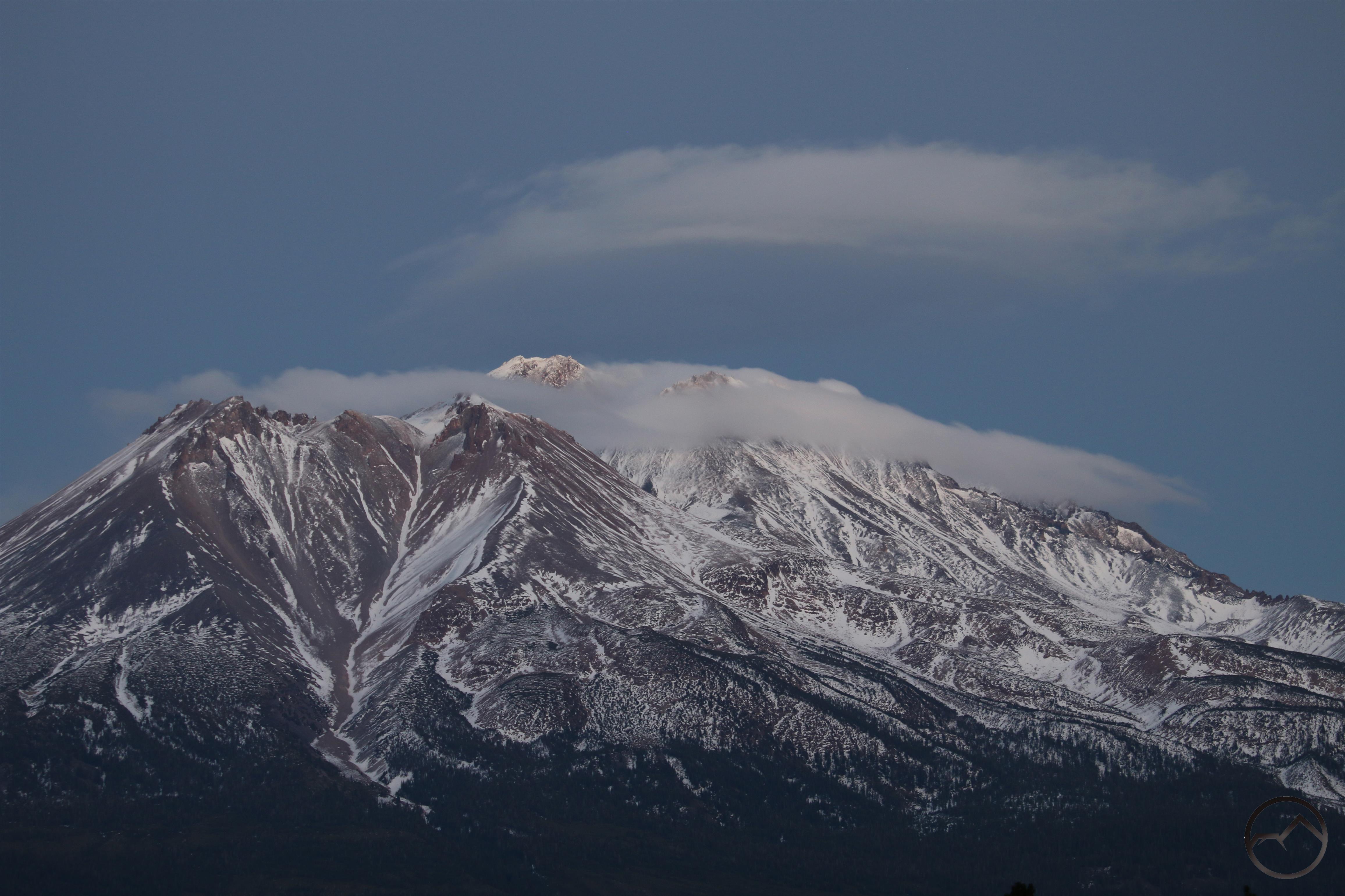
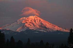
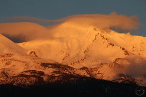
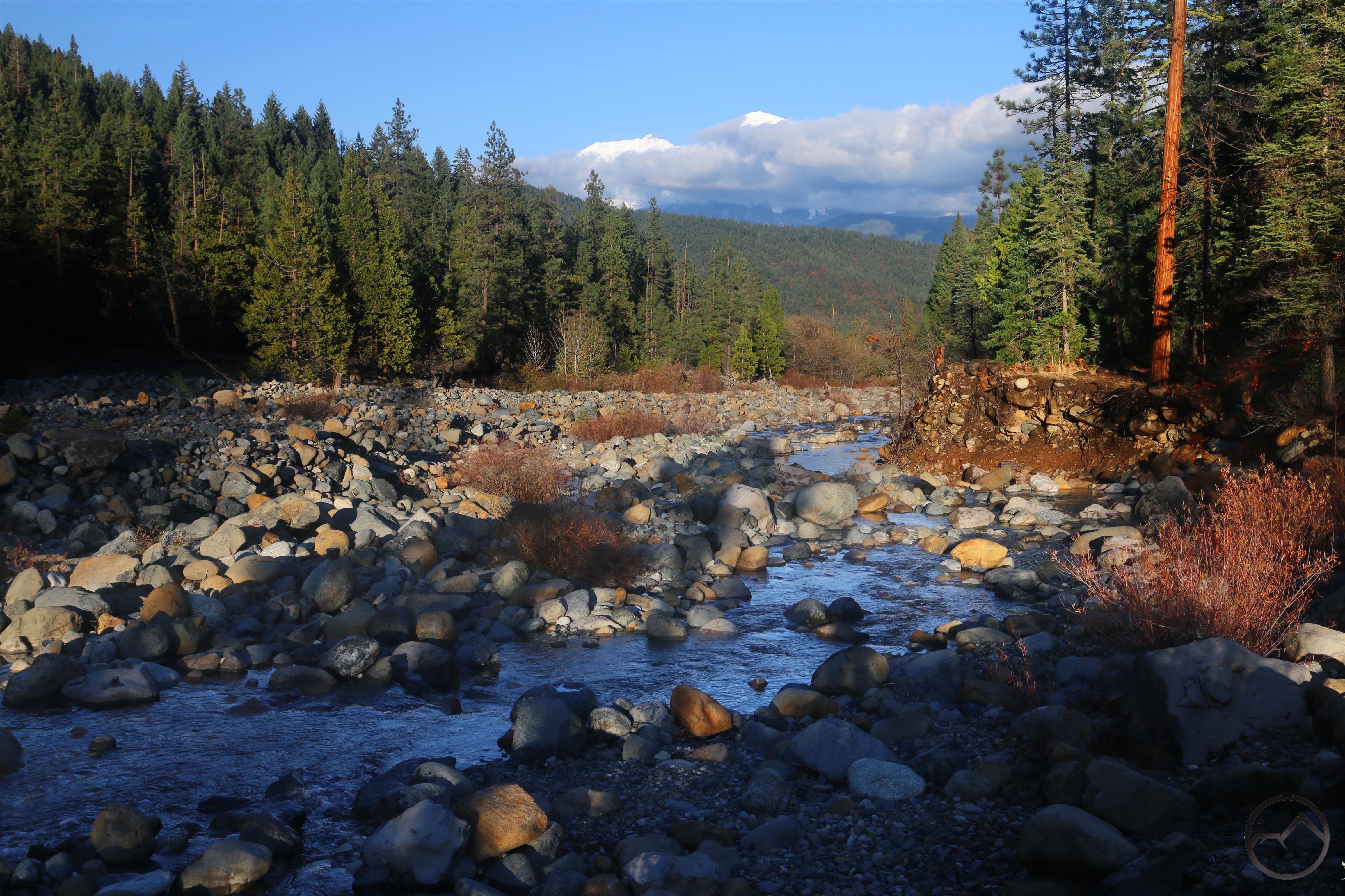
The next day featured a large “lenticulish” cloud that was heralding a shifting weather pattern and the onset of more snow. This set up a what proved to be a beautiful sunrise on the final day of 2020.

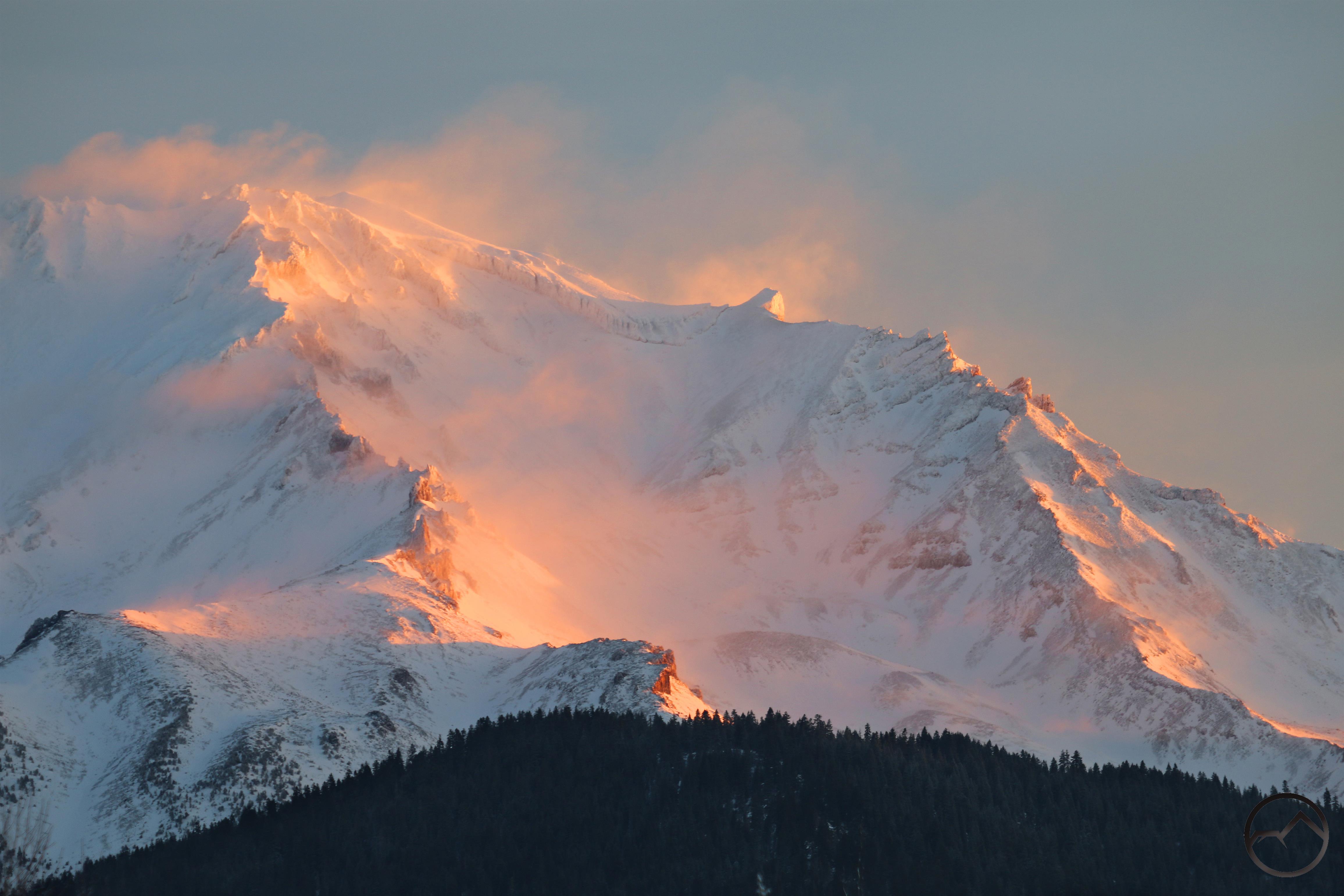
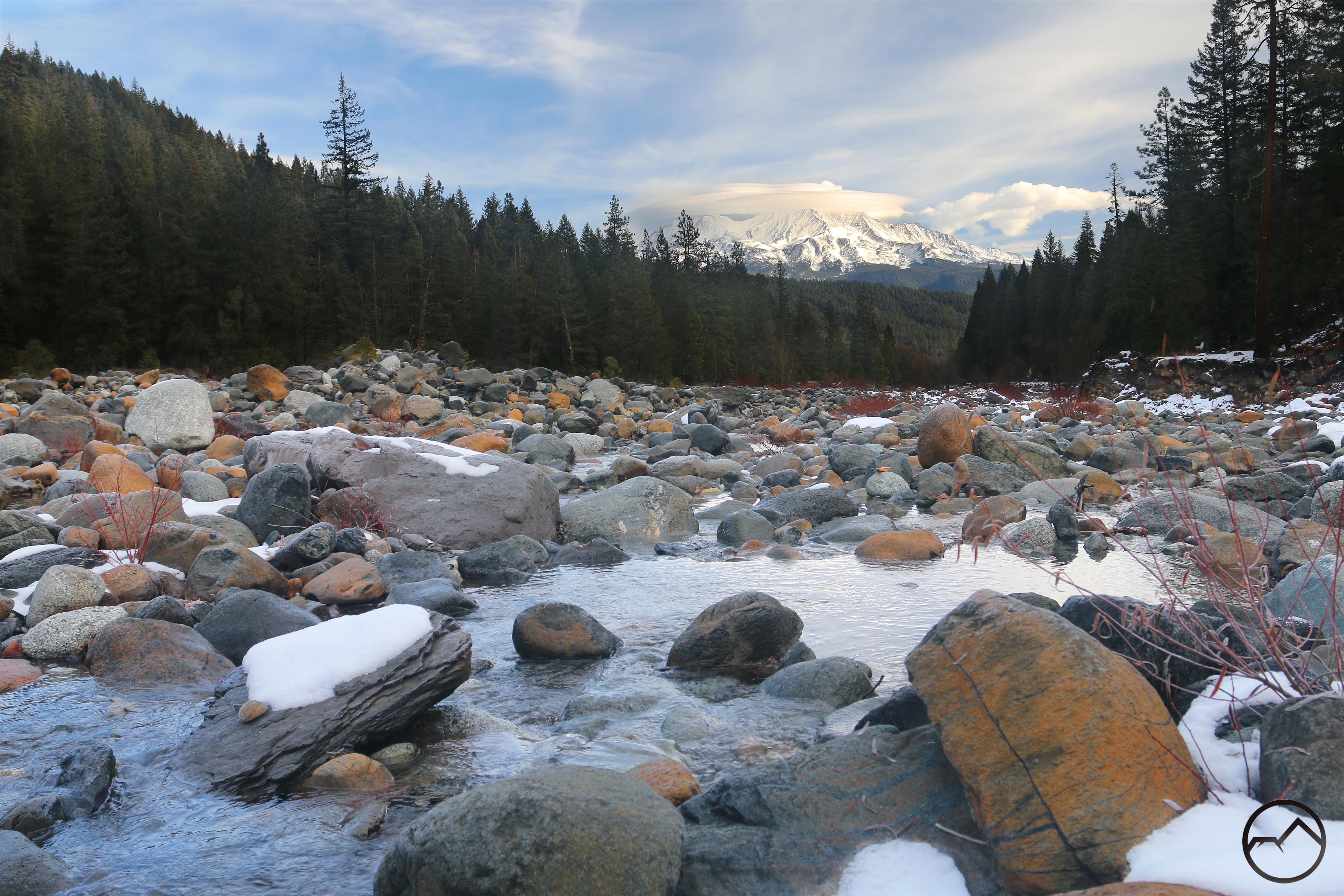
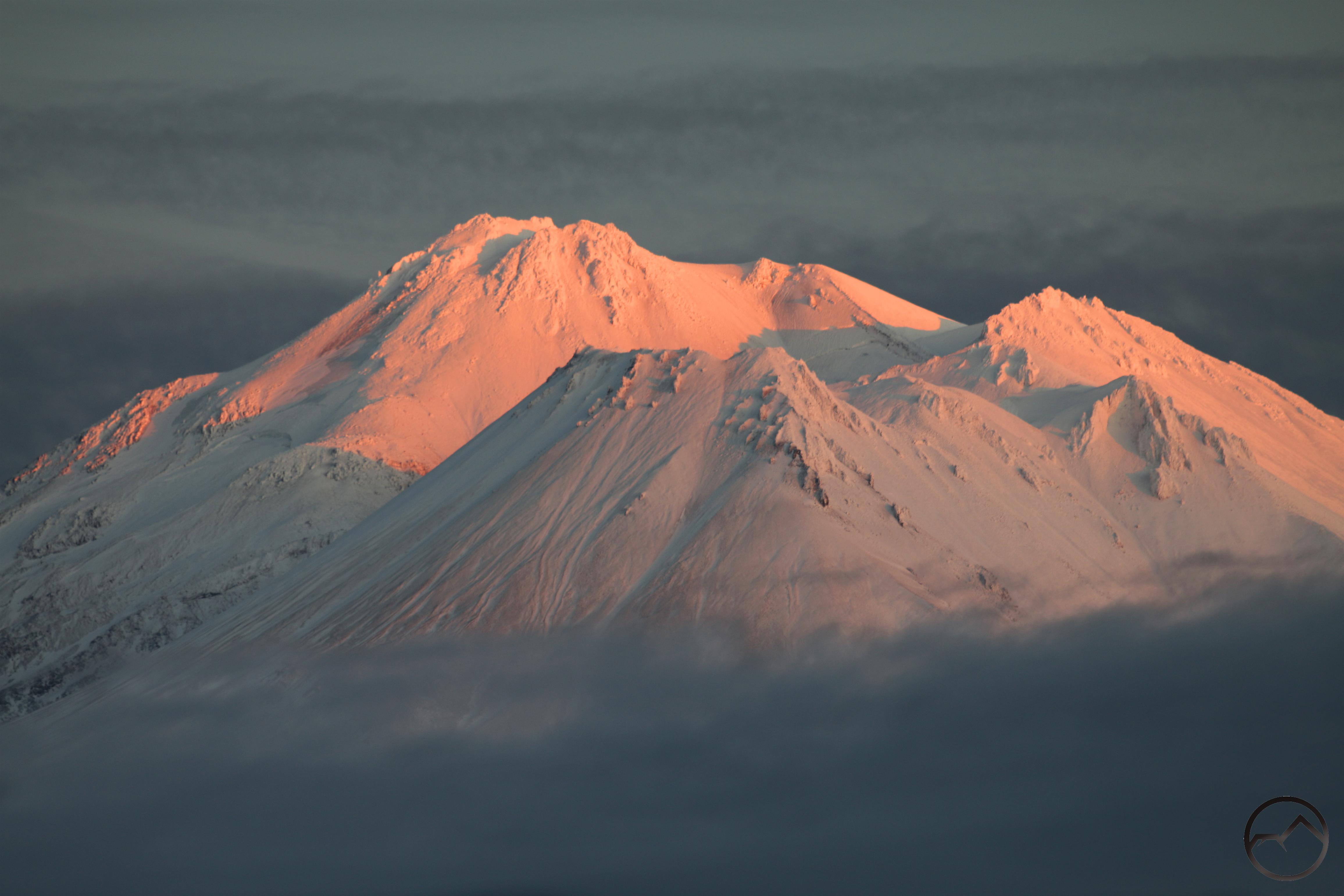
The glow on the billowing snow was sublime and the mountain seemed to glow to be exhaling powdery plumes with each breath, only to see them alight by the rising sun. It was a magical morning and the snowy scenery only added enchantment:

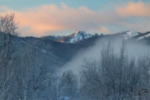
Castle Spire pierces the swift moving clouds.
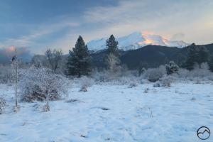
The snowy meadow is silent witness to Mount Shasta’s beautiful glow.

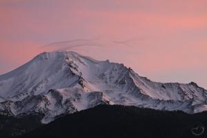
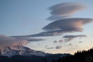
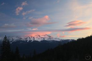
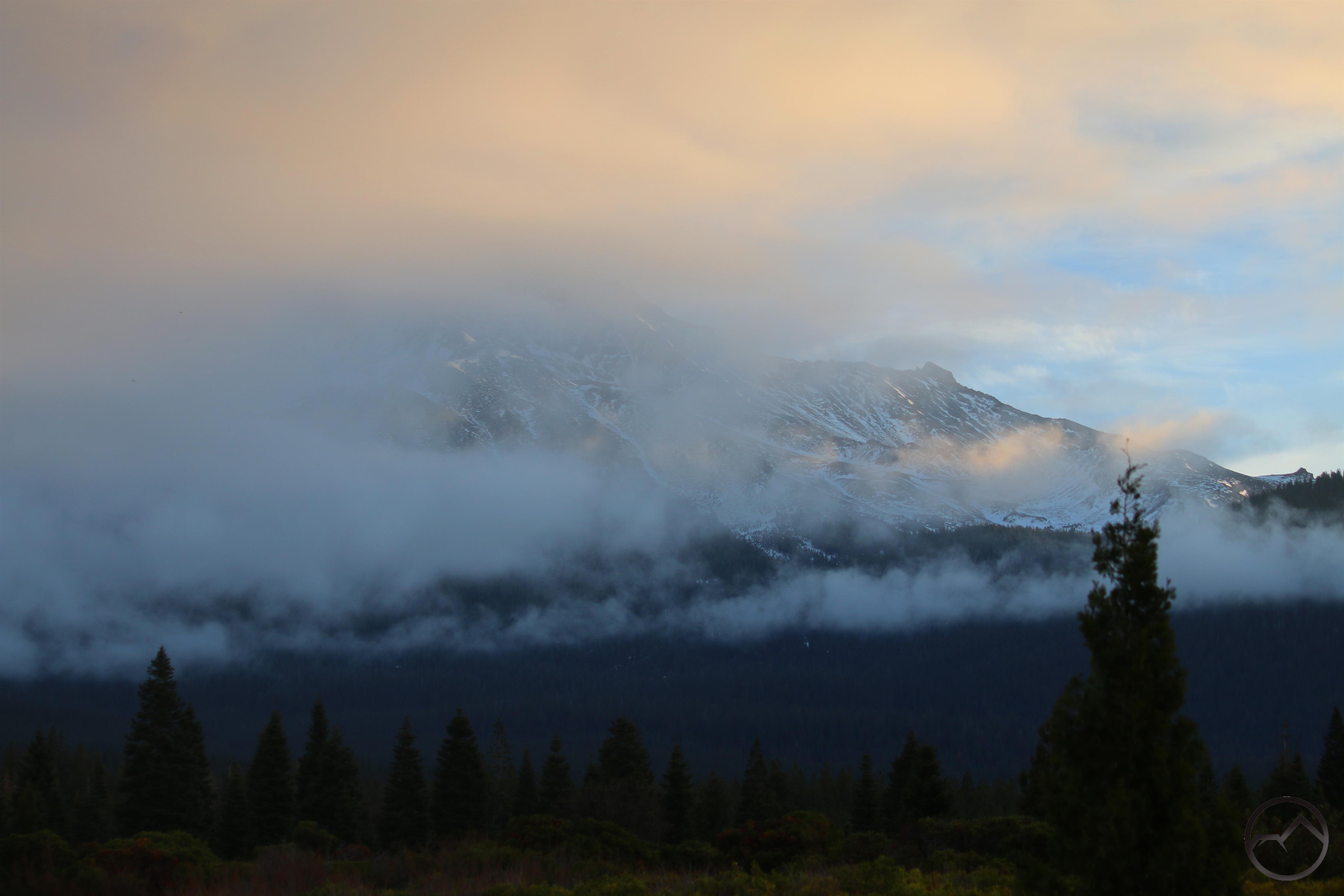
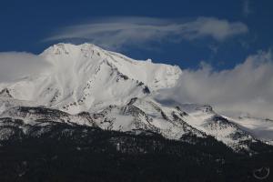
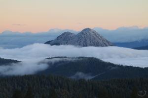
I kept an eye on the weather all day and eventually slipped out for a quick look at the sunset. The sky had become overcast, so the potential for color was significantly diminished. Nonetheless, Mount Shasta managed to brew up something interesting and make the sunset beautiful.

In the end, 2020 ended with a subdued but lovely sunset. Something makes me think 2021 is going to start off with a bang. I am excited to see what lies ahead!

The Solstice And The “Star”

Posted by bubbasuess on December 22, 2020
Posted in: Cascade Range, Hiking, Mount Shasta. 5 Comments

The one thing about fall that I really don’t like is the days getting noticeably shorter. After the summer solstice they shorten but are still long enough that it does not seem to change life much  but in the fall the length of day is so brief it alters how and when we do things. I do enjoy the low angle light and the ease of capturing the sunset since it comes so early. Thankfully, having reached the winter solstice, this trend now reverses itself and the days grow longer. It will take a while for this to manifest but psychologically, the relief has come.

The idea occurred to me to head out and capture the sunrise and sunset of the shortest day of the year. After the last three days lenticular activity it seemed like I might be able to catch something interesting. I was up early as usual for the sunrise but there wasn’t a cloud anywhere near Mount Shasta. I still set up just outside of town and watched the flecks of color show up on the crags of ridges of the mountain. On the western side of Mount Shasta, the first light only lights up those point protruding out far enough that the east face does not block all the light.

It wasn’t the greatest scene for my solstice effort but it would have to do. It almost seemed as if the weather was simply exhausted after its efforts over the last three days. Interesting, wavy clouds sailed through all day but by the time it was sunset, the sky had cleared out once again and it was empty over Mount Shasta. I went back to the same spot duplicated the perspective. At least if there was symmetry in the sky, there might as well be symmetry in images of the mountain.

The day may have  been over but the real spectacle had not yet come. Like many others, my family and I went out to view the “Christmas star”, the grand conjunction of Jupiter and Saturn. Their orbits, as well as earth’s position brought the two giant planets into extreme proximity in the western sky. Some have argued that this may have been the star seen by the Magi since the conjunction tends to occur around Christmas. This is incorrect both astronomically (rewinding the planets mathematically shows the conjunction would not have been that close during the reign of Augustus) and theologically. Nonetheless, it is a pretty awesome event to witness.

I set up my camera up on the slopes of Mount Shasta and, to my surprise, was able to see the four Galilean moons of Jupiter through my telephoto lens!

Saturn is on the right, Jupiter the left. The Galilean moons, Europa, Io, Callista and Ganymede are the dots on an oblique plane. Europa is hardest to see and lowest in relation to Jupiter.

My wife and I enjoyed the view for quite a while though my kids’ interest faded quickly and they played in the snow, in the dark, in the cold. As we looked both through the view finder and the naked eye, I noticed that my camera was able to peak up distant peaks in the Trinity Alps despite the light being almost completely faded. Sawtooth Peak and Mount Hilton both show up in the images I was taking! In the end, we finally packed up and headed home for eggnog and cookies. That interested the kids even more.

Jupiter and Saturn seen over the Trinity Divide. The high peaks of the Trinity Alps are visible on the horizon directly below the planets.

Though not the “Christmas star”, it was an awe-inspiring celestial vision and makes me ponder what it may have been like for the Magi following the star to Bethlehem. The wonder of seeing a unique phenomena in the heavens and questing after it was at least hinted at tonight, if only lightly. It’s not even Christmas yet and it has already been a great Christmas this year!

Mount Shasta: Three Days Of The Lenticular

Posted by bubbasuess on December 21, 2020
Posted in: Cascade Range, Hiking, Lenticular Clouds, Mount Shasta. 2 Comments

An epic lenticular sunrise on Mount Shasta.

I have commented repeatedly for nearly a month that this year’s lenticular season has been something of a bust. Like an early Christmas gift, the mountain finally offered up a truly excellent spectacle. This did not consist of just one event but in the past three days we have witnessed significant lenticular activity. None of the formations would rank among the best I have seen but I have never seen sustained activity for this duration. It has been a remarkable development, and one that will rank, if not among the greatest formations, at least among the most memorable. Three days is a long time for these notoriously fleeting formations to sustain itself on Mount Shasta.
Friday:
I have already recounted the lenticular from Friday in my last post. Of the three days, it was the least cohesive and well formed. However, it was obvious the mountain was trying to brew something up. The cloud was a large disk that floated just to the southeast of Mount Shasta. The day started off with just a small wispy cloud on the summit but around noon it began to grow and continued to gather strength throughout the day. However, it never seemed to quite pull itself together and take a form with more defined edges. Then, just before sunset, the clouds collapsed, and seemed to dissipate completely. I figured that was the end and considered it a near miss.


Saturday:
The next day began cloudless but around noon that began to change, just as it had on Friday. Though there had been no wispy formation on the summit, a large disk quickly formed in the same position it had been located the day before. It certainly seemed as though they were connected. This time, the cloud seemed to have more strength and looked to be forming more defined layers and edges. I was thinking that this would be the one. However, two things overruled that idea. First, the rest of the sky grew very overcast and appeared to negate the possibility of good light for an epic sunset. This proved to be the case until the very last minute, when the sun finally broke through and gave the mountain a little color. More unfortunate, however, was the seeming collapse, once again, of the lenticular just before sunset.

Around midday, there was a nice disk, complemented by other great clouds in the sky.
By afternoon, the sky had gotten more overcast and the mountain was in shadow.

Just before sunset, the cloud strengthened itself and formed nice layers but the sky remained dark.
Finally, sunlight broke through the clouds and hit Mount Shasta. Unfortunately, the cloud had nearly disappeared.

While I was dismayed about the loss of a really nice lenticular, I stayed by my camera, hoping the cloud might muster one last bit of strength before the light finally disappeared. To my surprise, this is what happened, though it never regained the great shape it had had before the sunset.

Once the sun was gone and the alpenglow had faded, I headed home. The entire way, in the fading light, I could see the cloud building back up again. I have enough experience with these clouds to know that if they gather strength after sunset, they will sustain through the night and I need to prepare for something special in the morning. That is just what I aimed to do.

Sunday:
I was up pretty early on Sunday and, joined by my oldest son (11) I headed out well before dawn. After getting just the barest amount of light to allow me to take stock of the cloud on Mount Shasta, I decided to head up to the vantage point on Castle Lake Road. From there we could get good light on the clouds and some sunrise light on Mount Shasta as well. That turned out to be a wise decision.

When we first arrived, the mountain was covered in a large wave and there was a nice stack of floating disks.
As the color crept into the sky, the disks began to collapse. The wave on the mountain was expanding.

Color finally hit the clouds just as the vestiges of the stack were fading. Other, large puffy clouds had developed and offered fine contrast to the wave.

While the sun moved closer to the horizon and the color was fading, other large lenticular plumes formed and collapsed rapidly. It was fleeting but stunning.
In the end, it was the wave over the mountain that sustained itself. The complexity of the formation kept me at my camera long after the sunrise’s color had faded.

After watching the sunrise, I decided to take my son to the Sacramento River and see what vantages were accessible. I have always wanted to shoot a lenticular over Mount Shasta from one of my favorite vistas. This proved to be a great morning for it. The river has much more water in it than it did a month ago and, with patches of snow and ice, made a beautifully, wintry scene from which to observe the mountain and clouds.

On the way home, we kept our eyes on the cloud, which continued to fluctuate and change shape. It almost seemed as though the stack wanted to reform. Clouds, if not with a disk shape but at least with unusually linear shapes kept forming in the same space once occupied by the disk stack. Naturally I had to stop and capture one more image.

Finally sated, I headed home. Throughout the day I kept my eye on the mountain and the lenticular above it. In the afternoon it began a contraction that lasted throughout the rest of the day. By sunset it was back to a small, poorly defined wisp over the summit of Mount Shasta. It seemed things had finally returned to where they had started Friday morning.

Thus ended an epic three days of the lenticular. It was at times frustrating that conditions never quite aligned the way I wanted them for much of the time. Sunday morning, however, more than made up for it and it was a grand spectacle to observe. As always, gratitude is something I stay focused on. I am grateful to be here in Mount Shasta, at the foot of the mountain. I am grateful to witness these awesome displays of power. I am grateful to be alive and to see this revelation.

A Spectacular Near Miss

Posted by bubbasuess on December 18, 2020
Posted in: Cascade Range, Hiking, Mount Shasta. 2 Comments

Friday morning I was up early to continue my quest for a sunrise lenticular. Though the season has thus far continued to underwhelm, I remain optimistic that things will improve and the mountain will finally yield a really epic display. I’d love for it to happen soon, since this seems to have overtaken any other subject I write about. One can hope.

When I awoke it was still dark, but I could tell there were clouds. The occasional blackness where there should be stars was enough to alert me to the fact that I might want to be out for the sunrise. I headed towards town, noting that a small wispy lenticular was flowing across the summit of Mount Shasta. With these kinds of clouds, it is sometimes best to head toward a side that catches early morning light. This means the east, south or southwest. In this case, I only made it as far as town before I decided to catch the sunrise from there. It turned out to be a gorgeous morning with lots of warm light glowing on Mount Shasta and lighting up the Trinity Divide.

Castle Spire, the highest point in the Castle Crags, juts into an orange morning sky.

Cottonwood Peak glows in the morning light while the sun has yet to reach the foggy Shasta Valley. 
Though Mount Shasta remains in shadow on the north side, the wispy lenticular catches morning light.

Though it was small, there was a notable lenticular floating to the southwest of Mount Shasta. It was too far out of way to get it in a decent image with Mount Shasta so I decided to head north. Though the mountain would still be in shadow, I might be able to catch an interesting perspective. Unfortunately the floating lenticular fluctuated in size too much to get an good shot at it. In spite of this, view from the north side of Mount Shasta was fantastic. The Shasta Valley, falling away to the north, was shrouded in fog while the peaks above it, including Cottonwood Peak and Oregon landmarks like Mount Ashland, Pilot Rock and Mount McLoughlin, were all glowing with pink light. Turning back to Mount Shasta, the small wisp still streamed from the summit of the mountain. It might not have been what I had hoped for once again but the morning was grand and I had no complaints.

I kept an eye on the floating lenticular all day. It remained for most of the day and, come afternoon, I headed out to see what it might do. Maybe this would finally be the sunset that illuminated a large lenticular.

In the late afternoon, the mountain fell into shadow and the lenticular began to waver, seemingly uncertain if it should hold its form or dissipate. 

As sunset approached it was soon apparent that the lenticular was giving up the ghost. This was not to be the sunset I had hoped for. 
Despite the loss of the lenticular, the sky still promised some kind of colorful display. Since I was already in the valley, I stayed and enjoyed the last light on the high desert hills. 

The view to the west was epic. If I had been at Orr Lake, this would have been the scene over Mount Shasta!

In the end, it was a near miss. Mount Shasta was grand as always but the lenticular just could not hold on until sunset. It may have been a near miss but it was a most magnificent one. I remain optimistic that the time is soon when conditions will hold and my quest will finally come to an end!


Two Mornings Around Mount Shasta

Posted by bubbasuess on December 17, 2020
Posted in: Cascade Range, Hiking, Mount Shasta. 5 Comments

The problem with this time of year is that something interesting can happen in the sky above Mount Shasta on any given morning. During the summer, the weather is more stable and the sky lacks interest. However, in the fall and winter there is always the possibility of a lenticular or some other interesting event that will make a great image. I am loath to let such a scene get by and since I tend to be an early riser and like the solitude of the morning, it has become something of a habit during the fall and winter to get up early, check the conditions outside and see if I am going to head out and try to capture something. That certainly has been my pattern of activity the last few weeks. If it is not precipitating, I have frequently found myself gallivanting around the mountain, looking for an angle on something going in the sky.

This week has seen me out running around on three mornings, though only two yielded anything interesting. Monday was the first day I was able to get out and check the conditions. It elevations  just a few hundred feet higher than in town it had snowed several inches, which meant that the morning was quite beautiful and wintry. While there were no great clouds, the fresh snow and the morning light still made for a very satisfying morning. It would certainly be nice to get more like this!

Sunrise on Mount Shasta. The band of cloud would ultimately expand, covering the mountain and causing me to head somewhere else.
I love this view of the Castle Crags in the morning, especially when the tree are laden with snow. This is pure winter glory.

The “twin cedar” view of Mount Shasta. The clouds were ripping through the pass, sometimes blotting out the mountain entirely, but it made for interesting viewing.
Mount Eddy was totally covered in cloud but it is possible to see just how lot the snow line was.

Black Butte, looking quite white.
The rime ice was really thick on Black Butte. The peak’s location on the pass makes it a frequent recipient of this kind of ice.

Tuesday proved to be less attractive. The forecast was such that it looked like interesting weather might yield something noteworthy around Mount Shasta. In fact, it was just simply overcast, with the clouds stick around at 9,000 feet. Recognizing that I wasn’t going to get anything, I went home and continued on with my day. It precipitated during the day but by afternoon it had cleared. On my way home from teaching a class (not a teacher professionally but I do teach one class each week) I stopped and pulled out my camera for sunset. I am always shocked at how the sky around the mountain can go from rain and snow to completely clear in just a matter of minutes. This certainly proved to be the case on Tuesday.

Wednesday morning things finally looked like it might get interesting. Looking at where the clouds were located, I decided to head to the south. This time of year, the south side of Mount Shasta gets the direct morning light and it can yield great sunrise images. Unfortunately, it can also be a bit of a frustrating endeavor to find good vantage points without the trees getting in the way. I went to one of my trusty locations and was delighted when the sky erupted in pink and purple light.

Interestingly, there was no direct light on the mountain. Instead, Mount Shasta glowed with the light reflected off the clouds that swirled about the peak. It was quite a stunning sight. Soon, the whole sky was lit up, while Mount Shasta continued to glow. However, clouds began to coalesce around it, partially blocking it from view.

Soon the clouds threatened to overtake Mount Shasta completely. However, the sun had, by this time, risen high enough for the mountain to receive sunlight directly. Spots of orange cliffs broke through the gray cloud. It was an unusually and interesting perspective.

In the end, this week has still failed to deliver a lenticular. This entire season has proven to be very underwhelming in terms of witnessing these unique and spectacular events. However, it is good to be reminded that Mount Shasta is more than a catalyst for these strange clouds. It is a grand and magnificent mountain all by itself and observing it in its glory it is a privilege, with or without interesting clouds.

Sometimes, The Beauty Is Too Great And Too Fleeting

Posted by bubbasuess on December 9, 2020
Posted in: Cascade Range, Hiking, Mount Shasta. 5 Comments

This has been a very strange autumn here in Mount Shasta. Typically, October and November are some of the most productive months for lenticulars and when the strange clouds are not about, the sky above the mountain is frequently aglow with bright colors and other cloud formations. This year, this has not been the case. There have been a few scattered lenticulars and some colorful skies but nothing that compares to years past. The same was once again true Wednesday morning. I have been heading out early in the morning when the weather has given some indication that there might be something interesting in the sky. I am an early riser naturally and I have always liked the drowsy solitude of the world before the sun cracks the horizon, so getting outside to catch a sunrise is both easy and a delight. This was once again true Wednesday.

The forecast had called for clouds, so I thought there might be something interesting to see. I headed north but as the sun began illuminate the low, eastern sky, it was obvious that the clouds were too low to the deck to be much good. Moreover, they looked to be blocking the view of the mountain. However, it seemed like the sky was clear just past Black Butte, and the clouds were just hovering to the north of Mount Shasta. I turned around and headed back south. I got just past Black Butte when the sky at once cleared and was bathed in pink light. I hopped out and got a dramatic shot of Black Butte holding back the clouds.

North of Black Butte, the clouds were thick and little light pierced through the gloom.

Mount Shasta, however, was only partially visible. The clouds smothering the Shasta Valley were sending tendrils past the mountain, threatening to overtake the volcano with increasing strength. Seemingly fitting for the mountain’s stature, it was the only bit of terrain, other than the partially submerged Black Butte, that was not overtaken by clouds. Both Mount Eddy and the high peaks of the Castle Crags Wilderness (Castle Lake area) were all lost in a thick vapory blanket. However, these were alight with the rising sun and glowed with a great radiance that seemed to fill the air with more pink light. The entire area was a gorgeous symphony of color, one that was too grand for me to hope to capture it in images.

Glowing clouds sail past Mount Shasta.

As I looked around, bits of the clouds sailed past Mount Shasta with great speed. It was obvious that any view of the icy giant was going to be fleeting. I could see pink clouds racing overhead, breaking off of the great sheet that covered the Shasta Valley and flying off to the south, spiraling and turning as the flew.

20201209_073734

20201209_073734

Finally, as I watched the clouds gather strength, they enveloped Mount Shasta and most of the mountain finally fell out of view.

Mount Shasta finally succumbs.

It was a beautiful morning. I felt that I ought to have been frustrated by it and the lack of great images. However, though it had been too great and too fleeting to document with my camera, I was more pleased than disheartened. Not all sights must make great images. Sometimes, the joy is in the seeing, the experience and the moment than the memento I can look back on to revisit the wonder and beauty. At least, this is what I tell myself. Perhaps I am satisfied with being able to use these sights as grist for my writing habit. Not much else I do these days elicits much of a muse in me. Thus, I am, in the end, grateful to be inspired to write something, which I enjoy not as much as photographing a beautiful sunrise but more than many other things I must spend my time on.

In the end, Mount Shasta reemerged from the clouds, but the sky itself became gray and dreary all day. It was a good day to educate my kids and split firewood. I kept an eye on the mountain though, hoping that the setting sun might give it one last burst of light. In the end I was rewarded for my perseverance. The clouds cleared and the mountain put forth a fantastic evening glow. It was grand and fleeting and then the sun sank so far beyond the horizon that all color faded from the mountain…until tomorrow morning. We’ll see if I am at it again.

A brief but beautiful sunset on Mount Shasta.

Rime Ice Aglow And A Fresh Layer Of Snow

Posted by bubbasuess on December 7, 2020
Posted in: Cascade Range, Hiking, Lenticular Clouds, Mount Shasta. 1 Comment

Saturday afternoon saw a great lenticular formation. It was possibly the best that has occurred thus far this season, though it was not a particularly epic one. Rather, it was a complex weave of small cloud tendrils fixed over the summit of Mount Shasta while large plumes lofted to the south. Unfortunately, I was not able to capture an image of the formation, since I was selling Christmas trees with the Boy Scouts. Instead, I had to watch the cloud in between cutting trees and tying them onto cars. Such is life sometimes and, even missing the cloud, I have gratitude for having witnessed it. There are few sights that make a finer backdrop to selling Christmas trees!

Once we closed the lot, I stopped on my way home and still managed to capture an image of Mount Shasta before the light totally slipped away. Frustratingly, the cloud had collapsed and there was little interest left in its form.

The last vestiges of a once excellent lenticular fade into darkness.

I was hopeful that the morning might bring a renewed lenticular and a spectacular sunrise. I got up early and, striking out to the north, it was evident that it had rained in the night. At first I was concerned I would not even see the mountain because the cloud cover was so thick. However, as I approached the Graham Lava Flow, the clouds melted away, revealing a clear, cloudless sky high above Mount Shasta. I had been passing through low-lying pea soup that was sitting in the valleys. Higher up, there was little of interest over the mountain. I went from concern I wouldn’t see anything to concern there wasn’t “anything” to see. Not that an enormous, 14,000 foot volcano isn’t anything to see.

In the darkness, it looked like some snow had fallen at higher elevations and that, by heading up onto Herd Peak, I would be able to get into it. With little in the sky to accentuate a picture, this seemed the best course of action. Upon arriving at one of my favorite vantage points on Herd Peak, it was quickly evident that there was only a small amount of fresh powder on the ground but the trees were encased in crystalline rime ice. This type of ice forms on objects as clouds passing through them when temperatures are freezing. Bits of cloud freeze onto the branches (or whatever else happens to be sticking up into the cloud). From far away, rime ice can look like snow but it is usually form-fitting to trees rather than piling up like white pillows.

Mount Shasta, just before the sun’s arrival. 

As I waited, I watched the low clouds I had driven through swirl around Black Butte and Mount Eddy far to the west. Every now and then, the summit of Mount Eddy would break through the dense blanket and catch a bit of predawn glow. Other than that, there was little in the sky, a far cry from the intricate lenticular from the previous afternoon. While I waited by my camera in the freezing cold, I noticed I was being silently watched by three cows and a calf. I had not expected company of that sort but enjoyed their presence while they observed me for 5 minutes or so. They wandered off just as the sunrise began in earnest. As the sun finally neared the horizon, Mount Shasta began to glow. Then, as the sun cleared the horizon, the high desert forest in front of me suddenly exploded into a glittering arid jewel. The snow on the grasses and the rime ice in the trees lit up and seemed to radiate their own brilliance. With Mount Shasta presiding majestically above this glorious scene, it was a most satisfying sunrise.

A sparkling Mount Shasta sunrise. It was not warm.

It though I did not feel sated, it finally seemed like time to pull myself away from the view and begin to head back home. As I headed off Herd Peak, I kept finding more reasons to stop and capture a few more images. An interesting snag or a nice cluster of sagebrush might be the key to a perfect scene and I have been pushing myself to try different perspectives than the ones I normally fall back on. Most don’t work out but occasionally I hit on something.

Not quite something, but I am trying.

As I drove home, I was quite pleased with how the morning had turned out. It was not the epic lenticular morning I had desired but it was a beautiful morning in spite of this. I have been getting frustrated by the generally clear sky over Mount Shasta and wanting more weather to make images more interesting. I had really hoped this would be the morning for something special, and it turned out it was, just not the way I had anticipated. As they say, you can’t always get what you want, but sometimes you get what you need.

Mount Shasta: Fire In The Sky, Fire In The Forest

Posted by bubbasuess on December 3, 2020
Posted in: Cascade Range, Hiking, Mount Shasta. 2 Comments

Today was kind of an odd one. It began with a fiery sunrise and ended with a fiery sunset of an unexpected and completely different kind.

It started out early. I knew there were going to be clouds this morning, so I headed out before dawn. The position of the clouds said I go north, so north into the Shasta Valley I went. Soon I found myself watching the color creep into the sky over Mount Shasta while listening to the racing water from Little Springs. It was a beautiful morning, with clouds lit aflame by the sun before it broke the eastern horizon. Soon I moved a little further west, and let some old snags cast twisted silhouettes into the burning sky. Between the sound of the water, the colorful sky and the beautiful mountain all touched by a gentle breeze, mornings don’t get too much more satisfying than that.

The first light of day sets Little Springs aglow. 

Snags make interesting shadows against the orange sky.

By the middle of the day, a stringy lenticular had formed over the mountain, but I was otherwise occupied and couldn’t dash out to capture it (I know, I know). Unfortunately it dissipated in the afternoon but there just enough clouds to head out and see if anything interesting might happen at sunset.

Too my surprise, it was not the sky that ultimately drew my eye. As I went north, I saw a pillar of smoke in a place that seemed both odd and strangely near. Heading over to check it out, I saw massive tongues of fire spreading across a brushy field. Just as I arrived there, the clouds broke and Mount Shasta was bathed in pink light as the sun was setting. The flames were disconcertingly large and looked almost out of control.

Some of the fires burning across a field. There was another large cluster of flames about 50 yards to the south.

Fortunately, I could see people moving about and bulldozers pushing things into piles. It was quickly evident that the fire was a controlled burn. I must confess, it looked like the most out of control controlled burn I have ever seen. In these days of dry forests and parched fields, it is disconcerting to happen across fire like this, at least when it is large enough to appear wild. Fortunately these were not and bulldozers are handy things to have around when working with fire.

A dramatic and fiery end to the day.

I decided to capture some images of Mount Shasta, though conditions were frustrating since the hot air made it very difficult to focus on Mount Shasta. In spite of this, I got some interesting images to memorialize an unusual and fiery end to another day at the foot of the mountain.

Perspectives On A Cloud: A Day Around Mount Shasta

Posted by bubbasuess on November 24, 2020
Posted in: Cascade Range, Hiking, Lenticular Clouds, Mount Shasta. 3 Comments

A beautiful fall Mount Shasta morning, still with some vestiges of autumn color.

Thus far, 2020 has not been a great lenticular season. Typically, October and November are some of the richest months for these spectacular clouds. I am always on a hair-trigger to head out and try to document them. This year, however, it has been pretty sparse, with only a few, and fleeting, formations worth trying to capture. With partly cloudy weather in the forecast for several days before Thanksgiving, I was on the lookout even a little more than I normally would be.

Sunday proved to be fairly overcast, with Mount Shasta barely visible through the clouds. It was with surprise then that I observed a fairly large and complex lenticular formation over the mountain after the sun had set and the clouds had cleared. My gracious wife encouraged me to go try to capture and image of it even though it was getting rather dark. Night photography is something I am definitely not skilled at but I could not pass up the opportunity to try to document the cloud. I took my oldest son and we headed off into the late twilight. The cloud was definitely worth observing but I had a hard time getting my camera focused and, in the end, it was just too dark. A near miss, but one that had me thinking that the next morning would be the morning for a spectacular lenticular. I would be ready to go and not miss this opportunity.

In the end, the cloud did not live up to what I had hoped it would be, but it was quite beautiful in spite of my grandiose expectations (which, based on what I had seen the night before, were not entirely unrealistic). While the cloud did not have the massive structure and complex flow I had wanted, it did have durability, which for fleeting clouds like lenticulars, is a quality worth noting. This gave me the opportunity to revisit the cloud time and again, throughout the day, allowing me the change of capturing it from sunrise to sunset. That in and of itself is a satisfying and noteworthy end.

At sunrise, the cloud was what I call a “dancer”. It hovered above the summit but did not hold a disk shape. Rather, it constantly changed shape, never holding a form.
A short time later, a different perspective on the mountain with the morning light. The cloud continued to hover over the summit, constantly changing.

A beautiful view from Lake Siskiyou in mid-morning. The cloud was coalescing into a more traditional lenticular shape, both thickening and taking on a layered, disk appearance.
By noon the lenticular was quite wispy and had reduced in size somewhat. It continued to dance above Mount Shasta.

Late afternoon had seen the growth of the cloud to include distinct layers over Shastina. The rest of the sky above the mountain had cleared but there were clouds below the summit and large ones to the north.
At sunset, the lenticular had shrunk down again, barely a vestige of what it had been. In spite of its diminutive size, it captured the alpenglow well.

It is worth noting there were a few other disks floating to the south of Mount Shasta that would have been nice to capture with the mountain, if the view from the north were not obscured by clouds. However, the clouds to the north looked like a massive wave about to crash down on Black Butte. Unexpectedly, the clouds yielded a small rainbow just below the small mountain. It was a surprising sight, and one I was glad to preserve.

In the end, it was not the best lenticular, but it was a great time chasing it around all day. I am confident the “big one” will show up soon!

Another Morning And Evening Around Mount Shasta

Posted by bubbasuess on November 20, 2020
Posted in: Cascade Range, Hiking, Mount Shasta. 10 Comments

Mount Shasta alight at dawn while fog covers the Strawberry Valley.

A couple of days ago I posted some images I had taken during a morning trip up to Bunny Flat along with a shot of late afternoon around the mountain. It has seemed like an age since I have been deliberate about getting up early to go out and check the conditions around the mountain or to watch closely what the sky was doing as sunset approached. I don’t know if I just grew lethargic or disengaged or something else that I can’t quite put my finger on. I wrote back at the end of September that I was coming back to the mountain after feeling detached for a long time. However, with the trip to Arizona and other events on the home front, I never got back into my rhythm.

However, with winter weather now setting in, I feel like I am emerging from hibernation and finally getting into my usual sunrise/sunset pattern. Case in point being Thursday morning. Once again, I was up early and out the door long before the sun was up. The payoff was a beautiful sunrise around Mount Shasta. I din’t get a lot of gorgeous images but getting back out at dawn, with with its companion silence broken only by the lonely mountain wind blowing, was invigorating. I feel like I am finally getting back in gear just in time for the winter weather.

My first stop was Castle Lake, where a slight dusting of snow covered the ground. Though the cliffs were white, I am not sure a lot of it was snow as much rime ice. The way the rocks and trees were coated white made it look like the clouds had been low to the deck.
The Strawberry Valley and Black Butte Summit were enveloped by thick fog. Black Butte pierced the layer dramatically. It was an island of prominence amid a roiling sea.

Sunrise on Mount Shasta was glorious.
On my way back home, I saw Mount Eddy had emerged from the fog, with just a few tendrils clinging to Lake Siskiyou and upper canyons of the Sacramento River.

The rest of the day, Mount Shasta was covered by clouds, though the rest of the sky was blue. In the afternoon I took the kids to the Sacramento River to play on the rocks. The river level has gone up considerably and some of their favorite rocks weren’t as easily accessible. Nonetheless, they had a good time as always, hopping on the rocks, crisscrossing the river and racing bark boats. I spent my time watching them, reading and catching an occasional image when Mount Shasta peaked out from behind the clouds.

As we headed back home it seemed the clouds had cleared on the north side of the mountain so I popped up into the Shasta Valley to catch the sunset. My kids know the drill, so they played out in the fields, climbed rocks and continued to have fun in the open country. It’s pretty amazing they can go from scrambling on rocks in a mountain river frolicking in high desert fields in a matter of minutes, all within sight of the great mountain. In the end, sunset finally came and we then headed home.

I was up again early this morning but without a cloud in the sky, I decided to stay home and write this post instead. Looking at the forecast, there is some interesting weather in the offing. I think I will continue to pursue it and the mountain.


Posts navigation

← Older Entries
Newer Entries →
    • Recent Posts

      • Winter Shows Up When It Will
      • January Rolled By With Mud, Then Very Dry
      • Mount Shasta 2025 – A Year In Images
      • Mount Shasta On Either Side Of Christmas
      • Adrift In An Ocean Of Fog
      • December Has Been Spectacular Thus Far Pt. II (A Magnificent Lenticular)
      • December Has Been Spectacular Thus Far Pt. I
      • Lenticular Interrupted
      • A Stormy Wave And A Truchas Sunset
      • Aurora Lenticularis
    • Enter your email address to follow Hike Mt Shasta and receive notifications of new posts by email.

    • Archives

      • February 2026
      • January 2026
      • December 2025
      • November 2025
      • October 2025
      • September 2025
      • August 2025
      • July 2025
      • June 2025
      • May 2025
      • April 2025
      • March 2025
      • February 2025
      • January 2025
      • December 2024
      • November 2024
      • October 2024
      • September 2024
      • August 2024
      • July 2024
      • June 2024
      • May 2024
      • April 2024
      • March 2024
      • February 2024
      • January 2024
      • December 2023
      • November 2023
      • October 2023
      • September 2023
      • August 2023
      • July 2023
      • June 2023
      • May 2023
      • April 2023
      • March 2023
      • February 2023
      • January 2023
      • December 2022
      • November 2022
      • October 2022
      • September 2022
      • August 2022
      • July 2022
      • June 2022
      • May 2022
      • April 2022
      • March 2022
      • February 2022
      • January 2022
      • December 2021
      • November 2021
      • October 2021
      • September 2021
      • August 2021
      • June 2021
      • May 2021
      • April 2021
      • March 2021
      • February 2021
      • January 2021
      • December 2020
      • November 2020
      • October 2020
      • September 2020
      • August 2020
      • July 2020
      • June 2020
      • May 2020
      • April 2020
      • March 2020
      • February 2020
      • January 2020
      • December 2019
      • November 2019
      • October 2019
      • September 2019
      • August 2019
      • July 2019
      • June 2019
      • May 2019
      • April 2019
      • March 2019
      • February 2019
      • January 2019
      • December 2018
      • November 2018
      • October 2018
      • September 2018
      • August 2018
      • July 2018
      • June 2018
      • May 2018
      • April 2018
      • March 2018
      • February 2018
      • January 2018
      • December 2017
      • November 2017
      • October 2017
      • September 2017
      • August 2017
      • July 2017
      • June 2017
      • May 2017
      • April 2017
      • March 2017
      • February 2017
      • January 2017
      • December 2016
      • November 2016
      • September 2016
      • August 2016
      • July 2016
      • June 2016
      • May 2016
      • April 2016
      • March 2016
      • February 2016
      • January 2016
      • December 2015
      • November 2015
      • September 2015
      • August 2015
      • July 2015
      • June 2015
      • May 2015
      • April 2015
      • March 2015
      • February 2015
      • January 2015
      • December 2014
      • November 2014
      • July 2014
      • June 2014
      • May 2014
      • April 2014
      • March 2014
      • February 2014
      • January 2014
      • December 2013
      • November 2013
      • October 2013
      • September 2013
      • August 2013
      • July 2013
      • June 2013
      • May 2013
      • April 2013
      • March 2013
      • February 2013
      • January 2013
    • Categories

      • Boy Scouts
      • Cascade Range
      • Castle Crags
      • Desert
      • Echo Point
      • Glaciers
      • Hiking
      • How things came to be…
      • Klamath Mountains
      • Konwakiton Outdoor Designs
      • Lakes
      • Lenticular Clouds
      • Maps
      • Marble Mountains
      • Meadows
      • Mount Eddy
      • Mount Shasta
      • Mount Shasta History
      • Napa County
      • Off Season Trails
      • Pacific Crest Trail
      • Peaks
      • Rivers
      • Rock Climbing
      • Scott Mountains
      • Seldom Seen
      • Shasta Valley
      • Sierra Nevada
      • Siskiyou Mountains
      • Sonoma County
      • Spring Trails
      • sunrise
      • sunset
      • Trinity Alps
      • Trinity Divide
      • Truchas Ridge
      • Uncategorized
      • Water
      • Waterfalls
      • Wilderness
      • Wildflowers
      • Wine Country
      • Winter Trails
      • Yosemite
    • Meta

      • Create account
      • Log in
      • Entries feed
      • Comments feed
      • WordPress.com
    • Copyright © 2013-2024 by Bubba Suess

      DISCLAIMER: Any use of the information contained in this site by any and all persons is done at their own risk. The operator of this site shall be held harmless from any and all alleged claims, demands, causes of action, liability, loss, damage and/or injury to property or persons whether brought by an individual or other entity. This indemnification applies, without limitation, to all actions by an individual or other entity as a result of their use of information contained in this site.

    Blog at WordPress.com.
    Hike Mt. Shasta
    Blog at WordPress.com.
    • Subscribe Subscribed
      • Hike Mt. Shasta
      • Join 983 other subscribers
      • Already have a WordPress.com account? Log in now.
      • Hike Mt. Shasta
      • Subscribe Subscribed
      • Sign up
      • Log in
      • Report this content
      • View site in Reader
      • Manage subscriptions
      • Collapse this bar
     

    Loading Comments...