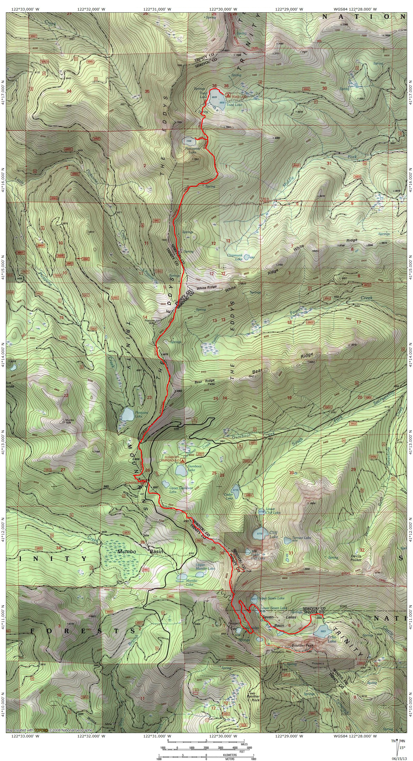
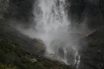
Hike Mt. Shasta

Exploring the Mount Shasta Region

  • Home
  • Trails
    • Mount Shasta Trails
      • Brewer Creek Trail
      • Clear Creek Trail
      • Gray Butte Trail
      • Green Butte Ridge Trail
      • Horse Camp Trail
      • North Gate Trail
      • Old Ski Bowl Trail
      • Panther Meadow Trail
      • South Gate/Squaw Meadow Trail
      • Whitney Falls Trail
    • Trinity Divide Trails
      • Blue Divide Trail
      • Castle Lake Trail
      • Castle Lake Shore Trail
      • Cliff Lake Trail
      • Deadfall Lakes Trail
      • Gray Rock Lakes Trail
      • Gumboot Trail
      • Heart Lake Trail
      • Porcupine & Toad Lakes Via Pacific Crest Trail
      • Seven Lakes Basin Via Pacific Crest Trail
      • Sisson-Callahan Trail
      • Soapstone Trail
      • South Mumbo Scramble
      • Tamarack Lake Trail
      • Toad Lake Trail
    • Castle Crags Trails
      • Burstarse Falls Via Pacific Crest Trail
      • Castle Dome Trail
      • Flume Trail
      • Lower Castle Crags Via Pacific Crest Trail
      • Root Creek Trail
    • Scott Mountains Trails
      • Bluff Lake & Cement Bluff via Pacific Crest Trail
      • Caldwell Lakes Trail
      • China Mountain Scramble
      • Cory Peak and Bull Lake via Pacific Crest Trail
    • Cascade Crest
      • Ash Creek Butte Scramble
      • Goosenest Trail
      • Juanita Lake Trail
      • Orr Lake Trail
    • Mount Shasta City Area Trails
      • Black Butte Trail
      • Box Canyon Trail
      • Gateway Trail
      • Lake Siskiyou Trail
      • Mount Shasta City Short Trails
      • Ney Springs Canyon Trail
      • Spring Hill Trail
    • Shasta Valley Trails
      • Black Lava Trail
      • Haystack Trail
      • Lake Shastina Trail
      • Pluto Cave Trail
      • Trout Lake Trail
      • Yellow Butte Trail
    • Sacramento River Trails
      • Dunsmuir Trail
      • Hedge Creek Falls Trail
      • Sacramento River Trail
      • Sims History Trail
    • McCloud River Trails
      • Ash Camp To Ah-Di-Na Via Pacific Crest Trail
      • McCloud River Falls Trail
      • McCloud River Preserve Trail
      • Squaw Valley Creek Trail
      • McCloud River Trail: Algoma Camp to Nitwit Camp
      • McCloud River Trail: Nitwit Camp to Cattle Camp Swimming Hole
      • McCloud River Trail: Cattle Camp Swimming Hole to Camp 4
      • McCloud River Trail: Camp 4 to Upper McCloud Falls
      • McCloud River Trail: Pine Tree Hollow Loop
    • Trails Further Afield
      • Trinity Alps Trails
        • Bear Lakes Trail
        • Billys Peak Trail
        • Boulder Creek Lakes Trail
        • Boulder Lake Trail
        • Canyon Creek Trail
        • Caribou Lakes Trail
        • East Boulder Lake Loop
        • East Weaver Lake Trail
        • Four Lakes Loop
        • Granite Peak Trail
        • Grizzly Creek Trail
        • Gulch Lakes Loop
        • Hidden Lake Trail
        • South Fork Lakes Trail
        • Stoddard Lake Trail
        • Stoney Ridge Trail
        • Tangle Blue Lake Trail
      • Warner Mountains
        • Emerson Creek Trail
        • Highgrade Trail
        • Patterson Lake Via Warner Summit Trail
        • Pine Creek Trail
        • Squaw Peak Trail
  • Articles
    • Trails By Area
      • Mount Shasta
        • Vistas, Meadows And Waterfalls: Three Best Hikes On Mount Shasta
        • The End Of The Road: Three Hikes In The Old Ski Bowl Area
        • Two Trails From Bunny Flat
        • Three Trails On Mount Shasta’s East Side
        • Mount Shasta’s Hummingbirds
      • Trinity Divide
        • Great Lakes: Top Five Lake Basins In The Trinity Divide
        • The Headwaters Of The South Fork Of The Sacramento River
        • Neglected Headwaters: Two Lesser Lake Basins On The South Fork
        • Gumboot Saddle: Two Hikes On The PCT
        • Descent Into Mystery: The Sisson-Callahan Trail
        • Mumbo Basin – Overlooked On The West Side
        • The Headwaters Loop: A Proposed Backpacking Loop In The Trinity Divide
      • The McCloud River
        • The McCloud River Trail
      • Shasta Valley
        • Jewels In The Desert
      • Scott Mountains
        • Great Scott! Two Scott Mountains Hikes On The PCT
      • Trinity Alps
        • Carubou Lakes: Trinity Alps On A Grand Scale
        • Switchbacks To Heaven: The Trinity Alps’ Stoney Ridge Trail and Four Lakes Loop
        • Trinities In Proximity: Two Trinity Alps Trails With Easy Access From Mount Shasta
        • Trails in the Carter Meadows Area
        • Trinity Alps Views of Mount Shasta
        • The Psychological Value Of The Trinity Alps
    • Waterfalls
      • Three Waterfalls On Mount Shasta
      • McCloud River Waterfalls
      • Sacramento River Waterfalls
      • Trinity Divide Waterfalls
      • Trinity Alps Waterfalls
      • Avoiding A Dry Whitney Falls
    • Off Season Trails
      • Three Winter Hikes Near Mount Shasta City
      • Winter Hikes In Shasta Valley
      • Winter Hiking In The Shasta Valley Wildlife Refuge
      • Winter Hikes On The Sacramento River
      • Winter Hikes On The Lake Siskiyou Trail
      • Spring Hikes In The Castle Crags
      • Spring Hikes On the Upper McCloud
      • Spring Hikes On The Lower McCloud River
    • Points Of Interest
      • Mount Eddy: Overshadowed, Underrated
      • Black Butte: Hiding In Plain Sight
      • Castle Dome: Steadfast And Staggering
      • Mount Shasta Hoodoos
      • Sacramento Scrambling
      • The Shasta River
      • The Castle Creek Watershed
      • Mount Shasta East Side Glacier View
      • 5 Fantastic Mount Shasta Vistas
      • 5 Highest Peaks Around Mount Shasta
      • 5 Best Hikes On Creeks And Rivers
      • 5 Interesting Footbridges
      • Three Spectacular Drive-To Sunset Vistas
    • North State Geography
      • Introduction
      • Seven Major Regions
      • The California Cascades
      • Klamath Mountains Pt. I
      • Klamath Mountains Pt. II
      • The Great Canyons Of Mount Shasta
      • Mount Shasta, Timberline, And The Relative Size Of Cascade Volcanos
      • Four Eruption Cones Of Mount Shasta
      • Mount Shasta’s Medial Moraine
    • Northern California Review
      • North Table Mountain
      • Lakes Basin Recreation Area
      • Eastern Sierra Fall Color
      • Sonoma County
      • Central Sierra Nevada
      • Orland Buttes
    • Seldom Seen
      • Ash Creek Falls
      • Mud Creek Canyon
      • Lower Mud Creek Canyon
      • Diller Canyon
      • Lower Cascade Gulch
      • The Grey Rocks
      • Castle Creek
      • Upper Wagon Creek
      • Fawn Creek Canyon
      • Confluence of the Sacramento River and Castle Creek
      • Upper Klamath River Canyon
      • Hole In The Ground Geologic Area
      • Ash Creek Butte Fossil Rock Glacier
    • Mount Shasta History
      • Vantage Lost: The Everitt Memorial Vista
      • A Yosemite-Mount Shasta Connection
      • Whitney – What’s In A Name?
      • Mount Shasta Area and the 1838 Exploring Expedition
      • A 19th Century Engraving Of An Epic Mount Shasta Vista
      • Vintage 1907 Color Photos
      • A Misleading Painting
      • A Mysterious Painting
      • A Mysterious Painting Pt. II
      • Stereographic Mt. Shasta
      • Year One Of Hike Mt Shasta
      • Year Two Of Hike Mt Shasta
      • Year Three Of Hike Mt Shasta
      • Year Four Of Hike Mt Shasta
      • Year Five Of Hike Mt Shasta
      • Year Six Of Hike Mt Shasta
      • Year Seven Of Hike Mt Shasta
    • Image Galleries
      • Mount Shasta Trails Gallery
      • Mount Shasta Sunrise Gallery
      • Mount Shasta Sunset Gallery
      • Lenticular Cloud Gallery
      • Mount Shasta NON-Lenticular Clouds
      • Mount Shasta Reflection Gallery
      • Telephoto Gallery
      • Mount Shasta Area Fall Color
      • Castle Crags Gallery
      • Waterfalls Gallery
      • Trinity Divide Lakes Gallery
      • Mount Shasta Area Rivers Gallery
      • Shasta High Desert Gallery
      • Mount Shasta GIF Gallery
    • Random Notes
      • Revew: Three Mount Shasta Trail Maps
      • A Mount Eddy Wilderness?
      • New Land Additions For The Castle Crags
      • Book Plug: Mount Shasta Area Rock Climbing
      • Exile: How I Came To Love Wilderness
  • Mt. Shasta Trail Map
  • Blog
  • About/Contact
  • Links
  • Truchas Ridge

Gumboot Saddle: Two Hikes On The Pacific Crest Trail

Posted by bubbasuess on June 16, 2013
Posted in: Hiking, Klamath Mountains, Lakes, Mount Shasta, Pacific Crest Trail, Trinity Divide. Tagged: Gumboot Lake, Mount Shasta, Pacific Crest Trail, Porcupine Lake, Sacramento River, Seven Lakes Basin, Toad Lake, Trinity Divide. 9 Comments
Trinity Divide, Many Lakes Mountain - June2012 065 copy (Custom)

Seven Lakes Basin.

In an earlier post, I highlighted two trails leading to a pair of lake basins at the headwaters of the South Fork of the Sacramento River. Though the South Fork is accessed via a paved road, these trails are not heavily used. Ironically, the road traveling up the South Fork canyon provides access to another pair of lake basins that see a bit more use, neither of which contributes water to the South Fork of the Sacramento. These trails are in fact sections of the Pacific Crest Trail, extending north and south from the trailhead at Gumboot Saddle, which marks the final extent of South Fork’s canyon. The northern section of the PCT follows the crest of the Trinity Divide to Porcupine Lake, which sits in an intimate, rocky cirque below the great pyramid of Porcupine Peak. Another mile beyond Porcupine Lake is Toad Lake, very different in character but still quite scenic. The southern section of the PCT quickly accesses the excellent Seven Lakes Basin. Side trails and an old dirt road split off of the PCT and provide routes to all of the beautiful lakes in the basin. There is also an opportunity to climb Many Lakes Mountain, which has one of the finest views anywhere in Northern California.
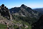
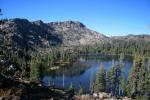
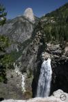
Trinity Divide, Porcupine Peak - Aug2008 056 copy (Custom)

Porcupine Lake.

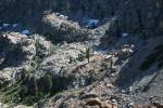
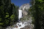
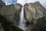
The Seven Lakes Basin and Porcupine Lake are two of the prettiest spots in the Mount Shasta area. Both boast cool, clear lakes, great views and awesome, rocky cliffs composed of gneiss. Toad Lake, near Porcupine, is also very scenic but is not in the same class as its smaller neighbor (it is still worth the hike in to it!). If I had to pick one hike as the superior, I would choose the trip to the Seven Lakes Basin. It has excellent views of the Mount Shasta area and the Trinity Alps. The hike to the Seven Lakes Basin also has more destinations and more options for exploration. This includes scrambles up both Many Lakes Mountain and Boulder Peak. The basin is also large enough to absorb lots of hikers without feeling crowded. While the Seven Lakes may be the better hike over all, Porcupine Lake is the prettiest of all the lakes accessed via the PCT from the Gumboot trailhead. The lake is fairly large and almost completely encircled in a rocky bowl. Only the east side is unenclosed and it has great views of Mount Shasta.

The two trails departing from the Gumboot Trailhead are among the longer day hikes in the Mount Shasta area. Both are frequently used as backpacking destinations. Since the Pacific Crest Trail provides entry to both lake basins there is already a built in expectation that one will see other people on the trail. Couple the through-hikers with those eager to hike great trails without having to drive dirt roads and you have one of the busier trailheads in the Mount Shasta area. Don’t let this be a discouragement. Busy by Mount Shasta standards is still lightly used by the crowd expectations in other areas.

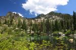
Pacific Crest Trail to Seven Lakes Basin

Trinity Divide, Seven Lakes Basin - June2008 042 copy (Custom)

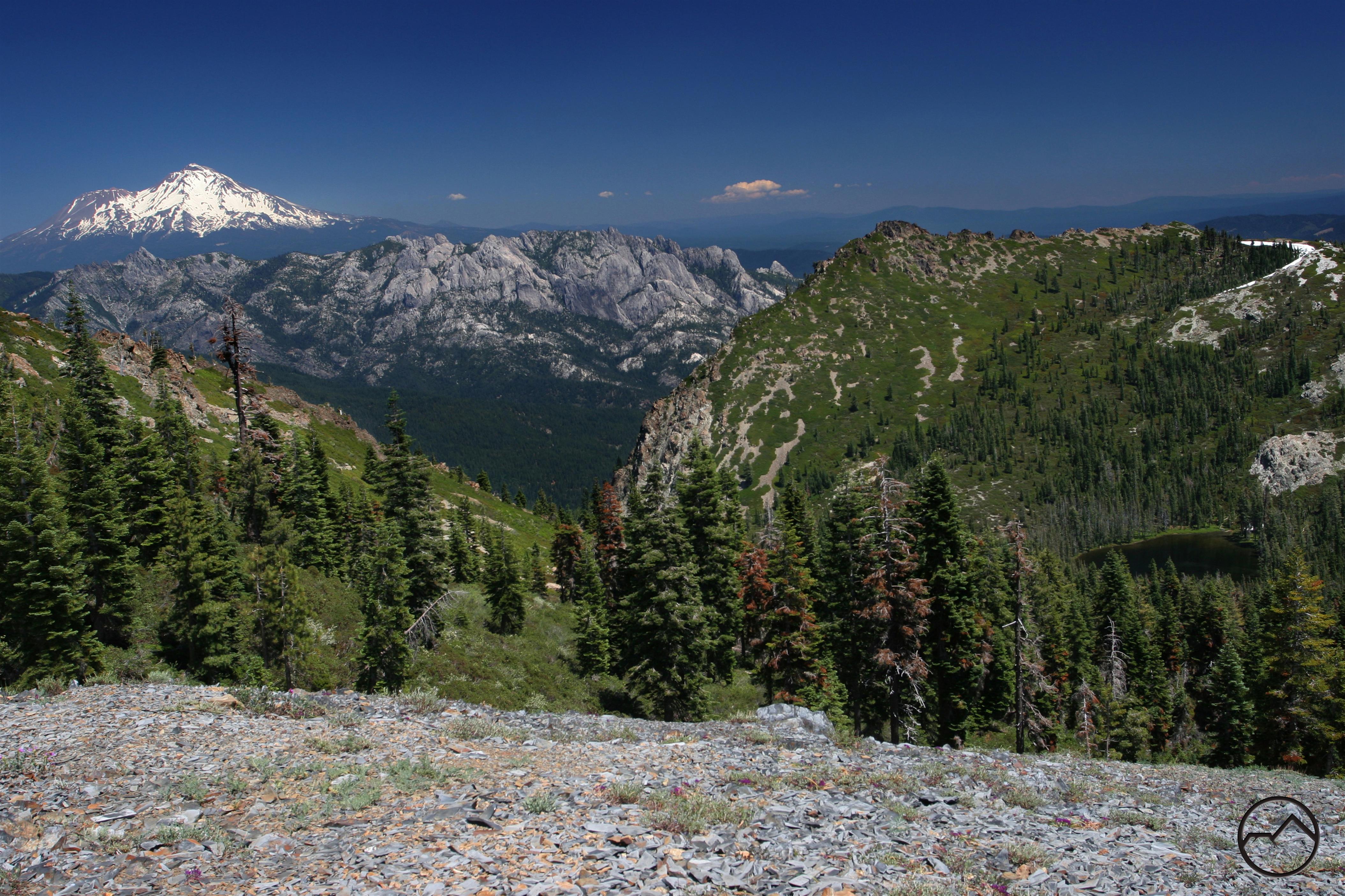
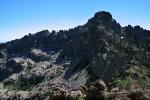
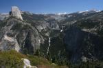
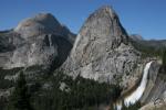
The Castle Crags, Boulder Peak and two of the seven lakes.

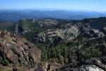
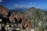
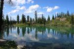
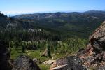
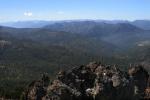
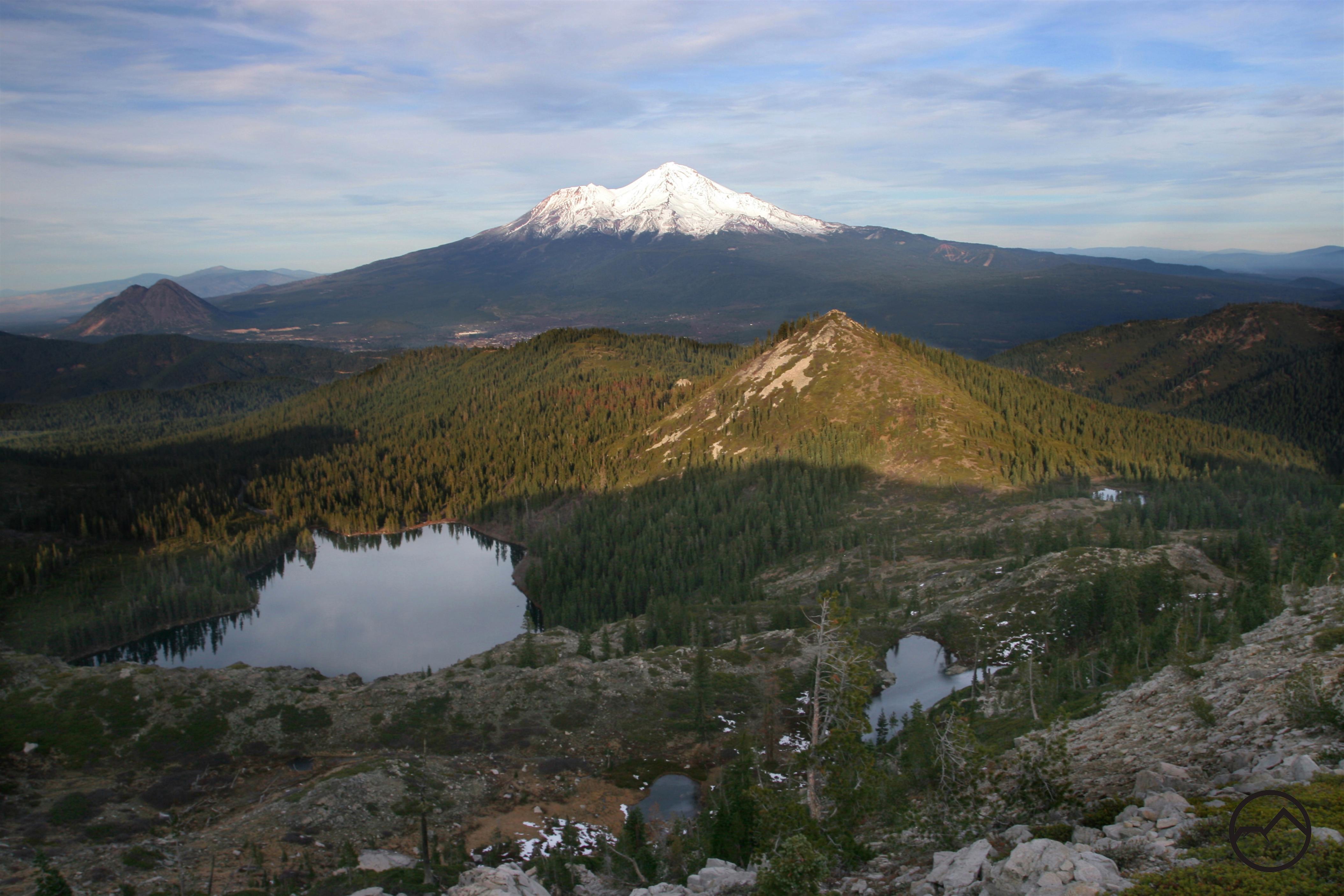
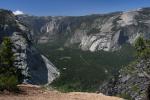
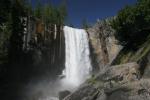
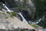
The Seven Lakes Basin constitutes the headwaters of the main fork of Castle Creek. The creek drains the area immediately to the south of the Castle Crags, which are visible from parts of the basin. Castle Creek is the largest of the tributaries that feed into the Sacramento River after the river leaves Lake Siskiyou. The trail to the basin is one of the most scenic in the entire Mount Shasta area. For little effort, the trail provides excellent views of Mount Shasta, the Trinity Alps and the Mumbo Lakes. An off trail scramble up Many Lakes Mountain yields one of the finest vistas anywhere in the Northstate, taking in the aforementioned sites and adding the Cliff Lakes, the Seven Lakes Basin, the mighty Grey Rocks, and almost all of the Lassen area, as well as reaching as far north as Mount McLoughlin in Oregon. In all honesty, it would probably be more accurate to rename the basin the Six Lakes Basin. One of the lakes is more like a pond on not nearly on the same level as the other lakes. Of the remaining six, only three are deep lakes. This does not mean the other three are not highly scenic, only that if swimming is what one has in mind, head to Upper and Lower Seven Lakes and Echo Lake. Part of Echo Lake is on private land, so please be sensitive to the property owners.

Pacific Crest Trail to Porcupine and Toad Lakes

Trinity Divide, Porcupine Peak - Aug2008 035 copy (Custom)

Porcupine Lake.

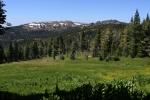
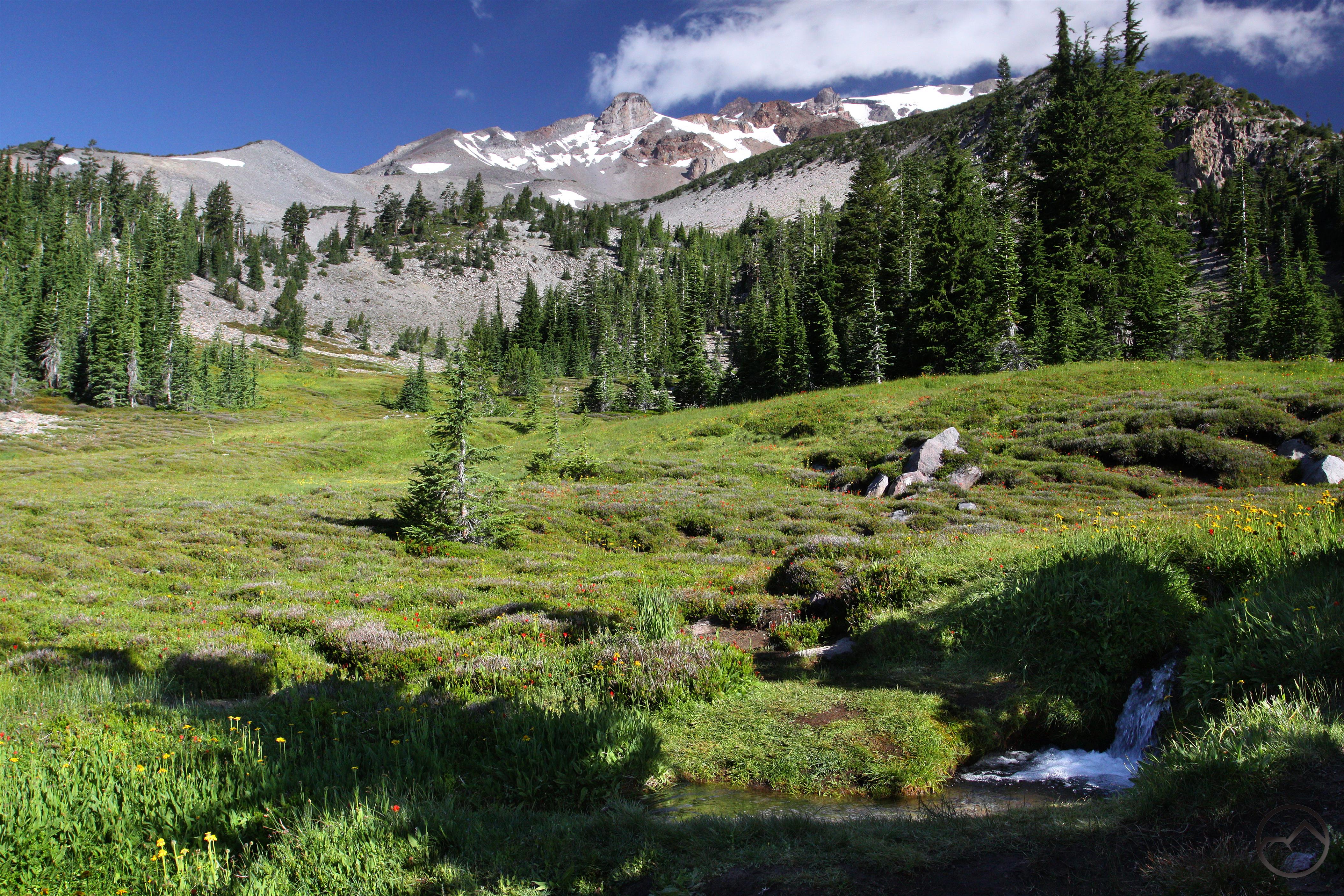
Following the PCT north from Gumboot Saddle to Porcupine and Toad Lakes is a fantastic hike with a high scenic factor. The trail maintains a fairly level grade so even though it is over 5 miles to Porcupine Lake, it does not feel like a tremendous effort has been expended. Along the way, the path scallops across the headwalls of both Fawn Creek Canyon and the Middle Fork of the Sacramento River Canyon. There are some good views toward the Trinity Alps in the west but most of the best views are toward Mount Shasta in the east. On particularly scenic spot comes along the rim of the Middle Fork Canyon, where a large complex of springs produces a large flower filled meadow. The grassy swale makes a great foreground for views of Mount Shasta. Finally arriving at Porcupine Lake, one is treated to one of the prettiest lakes in the Trinity Divide. The bowl is rocky and almost completely encircles the lake. The south side of the lake is dominated by the towering Porcupine Peak, a summit visible from the Mount Shasta City area. The north side has some fine peaks that are worth the scramble to the summit as well. Interestingly, Porcupine Lake has no outlet. Its waters seep underground and emerge as a spring down canyon. Nearby Toad Lake is not as scenic but is much larger and still very attractive. It is worth the extra effort to reach the lake, especially if one is spending the night at Porcupine Lake.

Gumboot2

Book Plug: Mount Shasta Area Rock Climbing

Posted by bubbasuess on June 14, 2013
Posted in: Castle Crags, Hiking, Klamath Mountains, Mount Shasta, Mount Shasta History, Rock Climbing, Trinity Divide, Wilderness. Leave a comment
Trinity Divide, Castle Crags - Nov2008 018 copy

The Castle Crags loom large across the Sacramento River Canyon. The Crags figure prominently in the climbing guide.

It is probably evident from the content on Hikemtshasta.com that I am a hiker. Although I dabbled in rock climbing earlier in my late teens and early twenties, it is not something I have much interest in pursuing at this point in my life. Of course, I have tremendous respect for those who participate in the sport and I am fascinated by the challenges that climbers have to overcome on longer routes. It is with this respect and fascination that I want to recommend the rock climbing guide, Mt Shasta Area Rock Climbing – A Climber’s Guide to Siskiyou County, which was recently published by my friend Grover Shipman. This is by far the most comprehensive rock climbing guide for the Northstate. As the title states, it covers crags all over Siskiyou County including several little known gems. However, the real heart of the book is Grover’s documentation of the incredible climbs in the Castle Crags. He went so far as to charter a helicopter to photograph hard to see areas. There is no other book like it. While great care and effort went into the description of rock climbing in the Mount Shasta area, Grover also put a lot work into gathering and documenting the natural and human history of the region and put together what is probably the first comprehensive account of the development of rock climbing in the area. With all the extra information, it is a great resource for anyone interested in the Mount Shasta area, not just for rock climbers. I heartily recommend the book.

Along with the book, I wanted to include a link to Grover’s new blog, Siskiyou County Outdoors. He is just getting it started but it has already has lots of great information on it. He is always eager to answer questions and is very friendly. Drop him a line!

Caribou Lakes: Trinity Alps On A Grand Scale

Posted by bubbasuess on June 11, 2013
Posted in: Hiking, Klamath Mountains, Lakes, Trinity Alps, Wilderness. Tagged: Caribou Lake, Caribou Mountain, Salmon River, Trinity Alps. 2 Comments
Trinity Alps, Caribou Lakes - July2009 113 copy (Custom)

Caribou Lakes and the granite heart of the Trinity Alps.

With the exception of Mount Shasta, the Trinity Alps are the most majestic and scenic mountain range in the California Northstate. The Trinity Alps Wilderness, which is a vast 525,636 acres, is one of the wildest corners of California. Here one finds mountains on a grander scale than any other mountain range in California, outside of the Sierra Nevada (and Mount Shasta, of course, but that is a solitary mountain, and excels against every mountain in the state, even the great captains of the Sierra Nevada). There are many great destinations in the Trinity Alps and it is debatable which is the greatest. However, by any metric, the Caribou Lakes must be considered near the top of the list, if not at the very top by themselves. This is alpine scenery at its finest and grandest with lots of white polished granite, enormous, deep lakes, verdant meadows and a vista to rival scenes in the most scenic of mountain ranges.

Trinity Alps, Caribou Lakes - July2009 035 copy (Custom)

Lower Caribou Lake.

Caribou Lake is the largest lake in both the Trinity Alps and the entire Klamath Mountains. At 72 acres, it exceeds its nearest competitor by at least 20 acres. Lower Caribou Lake, occupying a deep granite bowl below the main lake measures an impressive 30 acres, enough to rank it near the top of the list of lakes in the Trinities in terms of size. Snowslide Lake, the smallest of the main lakes in the Caribou Basin is nearly as large. Numerous smaller tarns litter the basin, providing private soaking pools for weary backpackers. Weary is what any who reach the basin must be. It is over 9 miles from the trailhead to the lakes via the New Caribou Trail, the easier of the two routes leading into the basin. This effectively prohibits access to the lakes to all but the most fit and extreme of day hikers. This is not a bad development since scenery this amazing is not totally off the radar. It filters out the less dedicated and reduces the number of folks who make it to this special place.

Trinity Alps, Caribou Lakes - July2009 080 copy (Custom)

The Stuart Fork vista.

The Caribou Lakes Trail has two of the most iconic views found anywhere in the Trinity Alps. One, from the top of the headwall above Caribou Lake looks down into the Stuart Fork of the Trinity River. The serrated towers of Sawtooth Peak preside like a monarch over the region while massive Emerald and Sapphire Lakes, stunningly large lakes in their own right, are cradled in a gargantuan granite bowl. To the south, the Stuart Fork flows toward the Trinity River while the great spires of Sawtooth Ridge gouge at the sky. This is a stunning and unforgettable vista. The other iconic view comes from the top of the Old Caribou Trail, as it reaches its apex atop the great shoulder of Caribou Mountain. Here the vast Caribou Basin spreads out below, with Caribou and Lower Caribou Lakes looking unforgivably distant after the hard climb necessary to reach the view. Beyond the lakes, the high peaks of the Trinity Alps, particularly the peaks of the granite heart of the range, line the horizon, a wild an inaccessible land.

Details for the Caribou Lakes Trail can be found here.

The Headwaters of the South Fork of the Sacramento River

Posted by bubbasuess on June 10, 2013
Posted in: Hiking, Klamath Mountains, Lakes, Mount Shasta, Rivers, Trinity Divide. Tagged: Cedar Basin, Cliff Lake, Grey Rock Lakes, Mount Shasta, Sacramento River, Trinity Divide. 9 Comments
Trinity Divide, Cliff Lake - July2011 015 copy (Custom)

Cliff Lake.

The Sacramento River is California’s largest and longest river. Most people’s exposure to it occurs in the Sacramento area where it is slow moving through the fields and city or as the broad giant that meanders through the Delta. A smaller but still significant number or people are familiar with the river as it lazily winds its way down the Sacramento Valley. It is a part of the lives of those who live around Redding, where the river passes through the city and still retains a little bit of its mountain character: swift flowing, navigating rapids and so on. Anyone driving up I-5 north of Redding has seen its waters impounded in Shasta Lake and followed its course from Lakehead to Dunsmuir. This stretch of river is raucous and scenic and is rich with wild character. Beyond Dunsmuir they leave the river behind and climb up towards Mount Shasta, the great geographic siren of the Northstate. Shortly after the Interstate and the Sacramento River part ways, the river flows through a very scenic chasm known as the Box Canyon. Upstream a little further it is impounded to form Lake Siskiyou. Further upstream from the lake one can witness the birth of the Sacramento River proper as the three forks forks of the river’s headwaters, the North, Middle, and South Forks, converge to form the river in its fullness. This opportunity is generally unknown to most folks and this is made more obscure by the fact that the large springs at the Mount Shasta City Park are billed as the headwaters of the Sacramento or, at the very least, the “spiritual headwaters”.

754447 copy

The Sacramento River, below the confluence of the three forks.

The three forks of the Sacramento that make up its headwaters arise in the Trinity Divide, the eastern breastwork of the great Klamath Mountains. These mountains are on the opposite side of the Strawberry Valley from Mount Shasta. Each fork begins its journey by forming at the head of a deep mountain canyon and tumbling furiously towards their convergence with the other forks. The North Fork is the wildest of the three and the only one not to begin in a lake basin. Instead, a massive complex of meadows gives birth to the river. No roads travel the canyon of the North Fork, which is only accessed by the remote Sisson-Callahan Trail. The Middle Fork headwaters are Porcupine and Toad Lakes. A road does reach up to Toad Lake but it is long, rough and dusty. Only the South Fork, which is the largest of the three, is accessed by a paved road. It also has the largest watershed of the three forks and is fed by several lakes from four separate lake basins. These basins, the Gumboot, Cedar (Cliff Lake), Soapstone, and Gray Rock, offer sustained water flow throughout the year from the lakes and the meadows that surround them. The presence of so many lake basins means that the South Fork of the Sacramento also has the most diverse hiking options. Two of the basins in particular, Cedar and Gray Rock, have great trails that lead to numerous highly scenic destinations. There is also a lot of potential for off-trail exploration in both of these lake basins.

South Fork Better

Headwater of the South Fork of the Sacramento River.

Gray Rock Lakes

427141 copy (Custom)

Looking down on the Gray Rock Lakes.

The easternmost of all the lakes in the South Fork area, the Gray Rock Lakes are nestled into a broad bowl. The entire basin was included in the Castle Crags Wilderness when the wilderness area was established in 1984. Unlike the Castle Crags, which are a classic granite formation, the rocky bowl containing these lakes is formed of a gneiss intrusion. The two types of rocks are related, but gneiss does not have all of the components of granite, such as mica, and is prone to banding (parallel layers in the rock). Three lakes are found in the Gray Rock basin: Gray Rock, Upper Gray Rock and Timber Lakes. There are also a few unnamed ponds, most of which are near Upper Gray Rock Lake. Two high peaks, Gray Rock Dome and Harry Watkins form the eastern and southern walls of the basin. The short Gray Rock Lake Trail traverses the canyon wall above the outlet creek. Gray Rock Dome looms prominently on the opposite side of the canyon. Once the trail drops down to Gray Rock Lake, there are a few different options. Paths lead to the upper lake and Timber Lake. Upper Gray Rock Lake is in a scenic bowl with attractive cliffs above it. Timber Lake has the most extensive meadows in the basin. Routes leading to the two aforementioned peaks depart from the lakes. The last 0.25 miles of the road leading to the trailhead is a bit rough so those without high clearance vehicles may want to park when the road degrades and walk to the trailhead.

Cliff Lakes

Trinity Divide, Many Lakes Mountain - June2012 048  copy (Custom)

Looking down on the Cliff Lakes.

The largest of the lake basins that feed the South Fork of the Sacramento, Cedar Basin is home to Lower Cliff Lake, Cliff Lake, Upper Cliff Lake as well as Cedar Lake and Terrace Lake. Numerous unnamed are tucked into rocky corners of the basin as well. These lakes are the ultimate source of the South Fork. It is fitting that the South Fork begins in such dramatic fashion. Water from Upper Cliff Lake and Terrace Lake cascades noisily into Cliff Lake, flowing down the massive cliff that rises out of the lake’s southern end. Cliff Lake’s cliff is one of the most dramatic features found anywhere in the Trinity Divide. Unlike the Gray Rock Lakes, Cliff Lake is accessed by a road rather than a trail. The road is very rough and is more easily hiked than driven. There is a trail leading from Cliff Lake up to Terrace Lake. From there, numerous smaller, unnamed lakes can be reached. The prettiest of these is tucked into a bench in Cliff Lake’s cliff. It is reached from Terrace Lake. Nearby there is a rough route leading down to spectacular Upper Cliff Lake. The west part of Cliff Lake is privately owned. A couple cabins occupy the site. Be sensitive to the owner’s rights.

Other Lakes Along The South Fork

Trinity Divide, Gumboot Lake - June2009 006 copy

Gumboot Lake.

There are two other basins that feed the South Fork. In terms of area, the Soapstone Basin is the largest but it only has two small ponds, only one of which does not dry up late in the season. There is a trail that climbs into the basin and eventually accesses the Pacific Crest Trail. Further up the South Fork Canyon are the Gumboot Lakes. The paved road reaches all the way up to the shores of Gumboot Lake where there is a small campground. Meadows ring the main lake while Upper Gumboot Lake is a bit rockier. These lakes are subtler than the Gray Rock and Cliff Lakes and lakes the large cliffs that give the others their impressive appearance. A short trail climbs above the lakes and connects to the Pacific Crest Trail at Gumboot Saddle. If camping at the lake, this trail, combined with a short section of the PCT to the south of the saddle leads to a fantastic vista overlooking the lakes with a great view of Mount Shasta.

Trails Beyond Mount Shasta: Trinity Alps

Posted by bubbasuess on June 6, 2013
Posted in: Hiking, Klamath Mountains, Lakes, Trinity Alps, Waterfalls. Tagged: Canyon Creek, Trinity Alps. 1 Comment

13 (Custom) (2)

The obvious intent of Hikemtshasta.com is offer the most complete coverage of the exceptional hiking opportunities on and around Mount Shasta. It is not my desire to overextend the site or to deviate from its core purpose of covering the trails in the immediate Mount Shasta area. However, there are several amazing places within easy reach of Mount Shasta that are exceptionally scenic and deserving of thorough documentation. The focus of Hikemtshasta.com will always be on the great mountain’s close vicinity but it would be a shame if the other regions in Mount Shasta’s outer orbit were left unacknowledged on this site. The difficulty comes with trying to meet the goal of being exhaustive. There are a few thousand miles of trails in the surrounding wilderness areas and other destinations. Documenting all of these routes is a massive undertaking and will certainly be a very lengthy endeavor. Still, if for no other reason than to raise awareness of the outdoor resources and stunning landscapes found in the California Northstate, it seems like the natural move to expand Hikemtshasta.com’s scope.

12 (Custom)

Upper Canyon Creek Falls.

Chief among the extraordinary areas a little further afield from Mount Shasta are the vast and spectacular Trinity Alps. The eastern fringe of the Trinities are only 30 miles to the west and are prominently visible from numerous trails in the Shasta area. These mountains are part of the expansive Trinity Alps Wilderness, which is just under 550,000 acres. This is one of the the most wild and rugged regions in California and a place so vast it is easy to lose oneself in the backcountry for weeks. The mountains are exceptionally scenic with huge granite peaks, deep glacially scoured canyons and valleys, dozens of alpine lakes, extensive alpine meadows, unusual bright red peaks all combined with a sense of deep isolation. For the first post on trails in the Trinity Alps, the obvious choice was the Canyon Creek Trail. It is the most popular trail in the Trinities and it is certainly one of the most scenic. This trail has it all: massive granite peaks, a large, roaring creek, huge waterfalls, meadows and gorgeous alpine lakes. This trail is one of the finest in all of Northern California.

Although I do not have a timetable for the rollout of additional areas that will be covered on Hikemtshasta.com, I plan on covering hikes in the Marble Mountains, the Siskiyous, the Warner Mountains, the Modoc Plateau, the Lassen area and the southern Klamath Mountains, which includes the Yolla Bolly Mountains. I may even expand into southern Oregon a bit. All of these will be found under the “Further Afield” category in the “Trails” drop down menu and and at the bottom of the trails listed in the sidebar. This is a pretty daunting task that will be years in the making, but I hope that it will help folks appreciate this part of California and make great memories in the area’s majestic mountains.

A Mount Eddy Wilderness?

Posted by bubbasuess on June 3, 2013
Posted in: Hiking, Klamath Mountains, Mount Eddy, Mount Shasta, Trinity Divide, Wilderness. Tagged: Deadfall Lakes, Klamath Mountains, Mount Eddy, Mount Shasta, Pacific Crest Trail, Sisson-Callahan Trail, Trinity Divide. 3 Comments
Trinity Divide, Mt. Eddy - Oct2008 006 (Custom)

Mount Eddy and Upper Deadfall Lake.

Mount Shasta dominates the California Northstate. It can be seen from the summit of peaks south of Lassen Peak to tall mountains deep into Oregon. Its massive bulk is obvious from as far east as the Warner Mountains, mere miles from the Nevada border. It is a wild, glacier-clad, regal mountain. It seems as though all other peaks fade into insignificance at the foot of the mighty volcano. Yet, despite the intimidating competition, there is one mountain in Shasta’s immediate vicinity that is worthy of far more acclaim that is receives and possesses many notable features in its own right. Mount Eddy, the second highest summit in the region, is a grand mountain in its own right. Without doubt, Eddy cannot compete with the grandeur or Mount Shasta, which stands a mile taller than Mount Eddy. Nonetheless, while Mount Shasta commands respect, Eddy at least demands some as well. Among the litany of notable qualities, Mount Eddy is the tallest peak in the Trinity Divide, is the tallest peak in the entire Klamath Mountain range and is the tallest summit in the United States west of Interstate 5. It is also one of 57 ultra-prominence peaks found in the contiguous 48 States (topographical prominence is the measurement of how high and independent a mountain is. It is measured from the first topographical line that encircles a peak and not higher mountain. Ultra-prominence is 5,000 feet of prominence or higher). If Mount Eddy were not stuck in the enormous shadow of Mount Shasta, it would receive more recognition for the grand mountain that it is.

601542 copy (Custom)

Mount Eddy and the Eddy Range from the Castle Crags Wilderness.

There are two wilderness areas in the Mount Shasta area. One encompasses the higher reaches of the great volcano. The other includes most of the granite spires of the Castle Crags in addition to an isolated alpine lake basin. Both of these wild lands are relatively small, though they do pack an inordinately large scenic punch. Of course, a little further to the west, there is nearly a million acres of wilderness divided between the Trinity Alps, Russian and Marble Mountains Wilderness Areas. Still, in the land immediately around Mount Shasta and Mount Eddy, there are only the two relatively small pockets of wilderness. In legal terms, an area that is designated as wilderness is left in its primeval state. No development can take place, no machinery be employed and natural processes are left to take their course. As the law famously states, man is a visitor in these lands. Typically, though not absolutely, lands that receive wilderness designation have notable and highly scenic qualities (this is not an official criterion for wilderness designation, but by their very nature it often works out that the wild lands are beautiful).

Trinity Divide, Mt. Eddy - July2010 005 (Custom)

Deadfall Lakes below Mount Eddy.

Without doubt, Mount Eddy has the scenic qualities worthy of wilderness preservation. In addition to multiple alpine lake basins and lush meadows, Mount Eddy is composed of bright multi-hued peridotite that usually manifests in yellow and orange. The Eddy Range and other nearby ranges such as the Scott Mountains and parts of the Trinity Alps represent the largest concentration of this kind of rock outside of Alaska. The rock also makes for poor soil the plant life in these areas are specially adapted to life in harsh conditions. The inhospitable environment also contributes to the barren appearance in Mount Eddy’s higher reaches. Thrown together, these elements combine to create an especially scenic, and in many cases, spectacular landscape. If it were not for Shasta’s mighty cone a few miles to the east, Mount Eddy would be a leading destination in its own right.

This raises the question as to why there is not a Mount Eddy Wilderness. If the mountain is worthy of wilderness designation and its special and scenic attributes are worth protecting, why has this not been done? It is not for lack of desire that it has not come to pass. The obstacle to wilderness designation lies in the 19th century. When the Southern Pacific Railroad laid track up the Sacramento River Canyon, the government, as was the normal practice at the time, gave the railroad sections of land (by section, I refer to a surveying section, which is one square mile and contains 640 acres) creating a checkerboard pattern of alternatingly private and public sections of land. Additional sections were sold to private individuals who had mining claims. Like much of the land between Mount Shasta and Redding, this was the case on Mount Eddy as well. The private inholdings, some of which constitute the heart of the Mount Eddy area, prevented the formation of a contiguous block of land necessary to establish a wilderness area. Even though wilderness organizations have recommended the creation of a Mount Eddy Wilderness, there have been too many roadblocks up until now.

The situation has changed in the past few months. In the fall of 2012, the Shasta-Trinity National Forest acquired more than 700 acres of land around the summit of Mount Eddy from a private owner. The national forest is now negotiating a sale for an additional 2,300 acres from the same owner. When these sales are completed, the necessary core for a wilderness to be created on Mount Eddy will be present. Conversations with the relevant personnel at the national forest have revealed that it is their intention to work toward wilderness protection for Mount Eddy once all of the necessary criteria have been met. The acquisition of the private inholdings is the most significant of these. There will probably be little opposition from private groups since most of the use on Mount Eddy already consists of recreation that would continue after the establishment of the wilderness area. Of the current uses only snowmobiles and OHV would be restricted. Of course, wilderness designation requires an act of congress, so even once all of the necessary steps have been taken, it is uncertain when the process will be completed. This is also a contentious issue with people who are sensitive about private landowner’s rights. I count myself one so concerned but this land is already owned by the federal government and will not effect private owners. Indeed, private ownership is what has prevented this action up until now and it is their desire to sell that has initiated the move toward wilderness preservation on Mount Eddy.

835857

Sections acquired in red. Sections under negotiation in blue.

Trinity Divide, Porcupine Peak - Aug2008 056 copy (Custom)

Porcupine Lake, at the southern end of the proposed wilderness.

What will be included in the Mount Eddy Wilderness? At this point, it is impossible to predict. An early proposal from the Calwild organization included a significant portion of the Scott Mountain north of Mount Eddy. This would have included the Bull Lake and Caldwell Lakes areas. At this point, I think that this becoming a reality is unlikely. Nonetheless, a significant amount of roadless land can be cobbled together that would incorporate most of the Eddy Range. It is possible to include all of the lakes on Mount Eddy, the North Fork of the Sacramento Canyon and even the Toad and Porcupine Lakes basins. The wilderness would essentially encompass the crest of the Eddy Range and descend down the upper portions of the North Fork and Middle Forks of the Sacramento River. This area is already prime hiking territory and has many great off-trail scrambles too. The establishment of a Mount Eddy Wilderness would further emphasize the hiking and backpacking use of this land and preserve it in its primeval state.

Mount Eddy Wilderness

My proposal for the Mount Eddy Wilderness.

Trinity Divide, Mt. Eddy - July2010 016 (Custom)

Mount Shasta viewed from Mount Eddy.

There are a few great trails in the area that would constitute the Mount Eddy Wilderness. Most notable is 10.5 miles of the Pacific Crest Trail. The southern portion of this makes a great hike up to Porcupine & Toad Lakes. The northern portion of the Eddy section of the PCT leads to the beautiful Deadfall Lakes, one of the prettiest areas in the Northstate. Another trail climbing out of Deadfall Meadows also arrives at the basin, where there are a series of beautiful alpine lakes. From there a trail leads to the summit of Mount Eddy and the finest view anywhere in the Northstate (I think it is better than the view from Mount Shasta because you can actually see Mount Shasta). The Sisson-Callahan Trail also climbs out of Deadfall Basin and descends into the canyon of the North Fork of the Sacramento, which it then follows all the way to the main fork of the river, 12 miles distant. There are also great off trail scrambles to grand but elusive lakes like Little Crater, Dobkins and Durney Lakes. It is an area ripe for exploration.

Seldom Seen: The Grey Rocks

Posted by bubbasuess on May 30, 2013
Posted in: Hiking, Klamath Mountains, Mount Shasta, Seldom Seen, Trinity Divide. 25 Comments
5 (Custom)

The Grey Rocks tower above Cerulean Lake.

Northern California is teeming with anonymous and unappreciated mountains. Although nearby Mount Shasta may famously be as lone as God, no great peak in the region is as forsaken and lonely as the Grey Rocks. Towering prominently above the surrounding landscape, their dark, brooding mass is glimpsed for a tantalizingly brief moment when traveling south on Interstate 5 from Mount Shasta. Aside from this abrupt vista, the Grey Rocks are only observed from parts of the Castle Creek drainage, from high in the Trinity Divide or the Trinity Alps, or from the slopes of Mount Shasta. The difficulty in observing the Grey Rocks is only surpassed by the challenge of accessing them. No trails lead into the massive complex of peaks and the only roads in the area are generally poor and seldom used. Access is further complicated by the presence of immense brush fields that block off the most obvious approach routes to all but the most self-punishingly motivated. What these impediments have obscured is one of the most breathtaking mountain landscapes in the California Northstate. All the ingredients of an outstanding alpine experience are present: high, jagged, rocky peaks, numerous gorgeous glacial lakes with exceptional fishing, lush meadows and incredible vistas. And yet, despite the superlative attributes claimed by the Grey Rocks, this awesome cluster of peaks is completely off of the radar of hikers and peak baggers.

10 (Custom)

The south summit of the Grey Rocks.

I first became aware of the Grey Rocks while going to school in Chico 13 or 14 years ago. I went to the Castle Crags to hike and prior to setting out on the Castle Dome Trail, I walked out to the viewpoint near the trailhead. The vista takes in views of Mount Shasta, the Castle Crags and the Grey Rocks. I had noticed the peaks briefly high above I-5 but this was the first time a name had been given to the peaks. Years later, when I returned from my sojourn in Texas, my curiosity about things seldom seen was more developed and engaged. I researched the peaks but nearly nothing was written about these dark, mysterious towers. The most significant entry I found was a reference to climbing the Grey Rocks in a well-known hiking guide covering the entire state of California. In a poorly written entry on the “Tamarack Lake Trailhead” (which does not, in fact, exist) there is a brief aside about a rugged route departing from the aforementioned lake and leading to the summit. While not commenting on the overall quality of the guide, I can testify that this is erroneous. An ascent of the Grey Rocks from the direction of Tamarack Lake stretches the meaning of the word “rugged”. Such a journey, if undertaken would be long, steep and pass through one of the most hellacious brush-fields imaginable with nothing remotely approaching a trail. Noting the paucity of beta on the Grey Rocks, I resolved to find a route to the summit myself.

Grey Rock Lake, Castle Crags and Mount Shasta.

Grey Rock Lake, Castle Crags and Mount Shasta.

Over the next couple of years, I made a few investigative trips around the base of the Grey Rocks, exploring the area and trying to ascertain the best route to the summit. One of the first things I discovered was that there was a trail of sorts, traversing the southern flank of the Grey Rocks. In truth, it was an old and seldom used road that passed an extremely lush meadow and led not to the Grey Rocks but to Grey Rock Lake and a scramble to the top of nearby Flume Creek Ridge. Attempting the summit from this route was completely unrealistic because of the aforementioned epic brushfield. Consequently I shifted attention to the north side of the Grey Rocks. It came as a complete surprise when, while on one of these exploratory trips, I discovered a heretofore unknown lake beneath the rocky north face of the Grey Rocks. It was a moment of great satisfaction. There were no trails, no fire pits, no foot prints and no trash around the lake. I felt as though I was the first person to have discovered this tiny, azure body of water. From the lake I spied what seemed to be the quickest route to the summit. Following this discovery, I returned the next summer and finally reached the top of the mountain that had captured my imagination years earlier.

11 (Custom)

Tamarack Lake.

The Grey Rocks consist of two primary towers, northern and southern in orientation. There are a few other subordinate peaks as well. There are two large cirques, one on the north and the other located on the east side of the southern peak. I must confess that it still surprises me that such an awesome set of peaks with such amazing scenic qualities has remained almost completely anonymous for so long. While the peaks themselves are extremely craggy and have a lot of character, they are surrounded by a great deal of exceptional scenery, most notably there is an abundance of lightly traveled or completely untraveled lakes. Bodies of water in an alpine setting always attract hikers and backpackers, so when a collection of lakes like the ones that surround the Grey Rocks escapes the notice of outdoor enthusiasts it comes as a real surprise. The largest and most frequently used lakes (this is relative, since few actually make it to these lakes as it is) are in the Tamarack Lake basin, immediately to the south of the Grey Rocks. The basin also contains the Twin Lakes and a few unnamed ponds. Tamarack, the largest of the three lakes in the basin, is a gorgeous alpine lake backed by a craggy set of gneiss-composed cliffs.

6 (Custom)

Cerulean Lake.

Closer to the Grey Rocks is solitary Grey Rock Lake, nestled in a deep bowl between the southern Grey Rocks highpoint and Flume Creek Ridge, which, though separated from the main bulk of the Grey Rocks is part of the peak complex. In addition to these large, deep, alpine lakes, there are three unnamed lakes nestled along the flanks of the peaks. The small lake I passed along the route to the summit I named Cerulean Lake, an obvious commentary on the lake’s gorgeous color. In the extremely wild and untraveled cirque on the east side of the peaks are two small tarns tucked into rocky troughs beneath the immense cliffs below the south summit. I named these Whalan and Mears Lakes, after the two named benchmarks on the south peak. This cirque might very well be the wildest place in the Mount Shasta area. Very, very few souls scramble the rocks here.

7 (Custom)

Mount Shasta and the Castle Crags from the summit of the Grey Rocks.

In addition to the awesome, rocky peaks and the inviting lakes, the views from the summit are magnificent and include one of the best perspectives on the Castle Crags with mighty Mount Shasta towering high above the granite spires. Most of the high mountain ranges of the Northstate, including the Lassen area, the Yolla Bollies, the Trinity Alps, the Marble Mountains, the Siskiyous and the Cascade Crest are all prominently visible from the summit. One can also peer down into the large cirque on the east side of the Grey Rocks and observe Grey Rock Lake and the diminutive Whalan and Meers Lakes. It is a remarkable site and well worth the climb up to the top. Considering the plentiful and fantastic attributes possessed by the Grey Rocks, it is startling how these mountains remain so seldom seen. For those interested enough to venture into their domain, a beautiful and wild setting awaits. For myself, getting to the summit was a deeply meaningful achievement, satisfying my hunger to follow in the footsteps of the mountain men of the 19th century. Not often does one have the opportunity to climb such a significant and attractive mountain and feel as though you were the first person to reach the summit. I am sure that others have climbed the Grey Rocks in the past but any evidence of other visitors is completely absent. In a way, it is comforting to know that such beautiful and wild places are still out there. I do not mean wild simply in that it is undeveloped and nature rules, but wild because it is still a blank spot on the map of the public awareness.

A Grey Rocks Gallery (Click to enlarge):

The south summit of the Grey Rocks.
The back side of Castle Dome (far right) is visible from the summit of the Grey Rocks.
isolated basin in the Castle Creek watershed.
Cerulean Pool and the Grey Rocks

Tamarack Lake
Winter view of the south summit.
Winter view of the north summit.
Mount Shasta from the Grey Rocks.

Cerulean Lake
Grey Rocks Meadow.
Tamarack Lake from the north tower.
The Trinity Divide from the summit.

Summit view of Bonanza King and the Trinity Alps.
Whalan Lake.
South Summit and Whalan Lake.
South Fork headwaters

A Yosemite – Mount Shasta Connection

Posted by bubbasuess on May 23, 2013
Posted in: Hiking, Mount Shasta, Mount Shasta History, Sierra Nevada, Yosemite. 14 Comments

Trinity Divide, Castle Peak - Nov2008 009 copy (Custom)

Since my last two blog posts were about Yosemite, I want to reorient back to the California Northstate (we few at the northern end of the state distinguish ourselves from the common conception of Northern California by referring to our area as the Northstate). This led me to consider the link between Yosemite and Mount Shasta. Folks would be forgiven for thinking that no such connection existed. If any area in the Northstate is likened to Yosemite or the rest of the Sierra Nevada, it is usually the granite towers of the Trinity Alps or, less frequently, the Castle Crags. Mount Shasta, being a great volcano of the Cascades, seems a range apart from the Sierra, the great 400 mile long spine of the Golden State. There is, however, a very important link between the greatest mountain in California with the state’s greatest mountain range. More precisely, it is a link specifically between Mount Shasta and Yosemite. It is not a connection of geography or geology, but rather a bond formed through human activity. The two great regions of California were both very dear to the great explorer and conservationist John Muir.

John Muir is commonly associated with the Sierra Nevada in general and with Yosemite in particular. It is less well known that Muir spent a significant amount of time in the Mount Shasta area. He summited the mountain on numerous occasions and explored its lower flanks and the surrounding mountains extensively. Justin Sisson, the father of the modern community of Mount Shasta City was a close associate of John Muir’s and the friendship drew Muir north almost as much as the mountain itself. Still, it was Mount Shasta that was the great fixation of Muir’s. He wrote extensively about the Shasta region, indicating his fascination with the area. Perhaps the best distillation of his feelings about the mighty cone and its surrounding lands are revealed in his most famous quote about the mountain:

“When I first caught sight of it over the braided folds of the Sacramento Valley, I was fifty miles away and afoot, alone and weary. Yet all my blood turned to wine, and I have not been weary since.”
– John Muir, Letters, 1874-1888

Cascades, Mt Shasta, Clear Creek - Aug2012 091 (Custom)

The flowery bee lands of Mount Shasta.

The exuberance for Mount Shasta seen from afar was magnified once John Muir got on the mountain. In one article, he is taken by the lushness of the mountain’s forests and meadows and writes in giddy fashion from the perspective of one of the volcano’s resident bees:

“In June the base of Mount Shasta will be as white with honey bloom as the summit with snow. Follow the bees and be showered with blossoms; take a baptism and a honey-bath and get some sweetness into your lives.”
-John Muir, Shasta Bees, 1875

Read the entire article here.

Without doubt, the most famous event John Muir recounted about the time he spent around Mount Shasta was the snow storm he encountered while on the summit of the mountain. He was part of a party that had summited the mountain and returned to their base camp (presumably somewhere around Horse Camp). The following day Muir and a guide returned to the summit to take more barometric measurements. While on top of Mount Shasta a violent storm moved in and pounded the two men with snow for 17 hours. They were able to survive the night by huddling alongside a sulphur spring that had a compliment of small fumaroles. The heat from these volcanic features was able to keep the two men warm enough to outlast the storm. When they descended the mountain, their clothes were completely frozen.

Read the whole article here.

While Muir certainly appreciated a trip to the top of Mount Shasta, he preferred the wild, rugged circumnavigation around the mountain:

“But far better than climbing the mountain is going around its warm, fertile base, enjoying its bounties like a bee circling around a bank of flowers…As you sweep around so grand a center, the mountain itself seems to turn, displaying its riches like the revolving pyramids in jewelers’ windows. One glacier after another comes into view, and the outlines of the mountain are ever changing, though all the way around, from whatever point of view, the form is maintained of a grand, simple cone with a gently sloping base and rugged, crumbling ridges separating the glaciers and the snowfields more or less completely. The play of colors, from the first touches of the morning sun on the summit, down the snowfields and the ice and lava until the forests are aglow, is a never-ending delight, the rosy lava and the fine flushings of the snow being ineffably lovely. Thus one saunters on and on in the glorious radiance in utter peace and forgetfulness of time.”
-John Muir, Shasta Rambles, 1874

Read the whole article here.

Fountains and forests on wild Mount Shasta.

The passion for Mount Shasta is apparent in John Muir’s writings. This raises the question about what he envisioned for the future of Mount Shasta. Naturally, he wanted to protect it in a way that hallowed its sublime beauty:

“The Shasta region is still a fresh unspoiled wilderness, accessible and available for travelers of every kind and degree. Would it not be a fine thing to set it apart like the Yellowstone and Yosemite as a National Park for the welfare and benefit of all mankind, preserving its fountains and forests and all its glad life in primeval beauty?”
– John Muir, “Picturesque California”, 1888

John Muir’s vision of a Mount Shasta National Park never came to fruition and many trees in the region and even on the slopes of the mountain itself fell to the logger’s axe. Nonetheless, at least an aspect of his dream was realized with the creation of the Mount Shasta Wilderness. The upper portions of the mountain are contained within the wilderness area, which was established by the 1984 California Wilderness Act. It currently encompasses 38,200 acres.

Indeed, John Muir loved Mount Shasta. His home may have been the Sierra Nevada and his first love was Yosemite, but Mount Shasta laid claim to a significant portion of Muir’s heart. His numerous trips the region, his ascents of the mountain and his extensive exploration of the surrounding ranges are all testimony to the great conservationist’s devotion to California’s mightiest mountain. This is all well documented in his copious writings, some of which are available here, here, here, here, here, and here.

Although this post is focused on John Muir, perhaps its sentiments are best expressed by the thoughts of John Muir’s conservation compatriot:

“I consider the evening twilight on Mt. Shasta one of the grandest sights I have ever witnessed.”
-Teddy Roosevelt

Trinity Divide, Heart Lake - Nov2007 016 copy (Custom)

Twilight on Mount Shasta.

Yosemite Addendum: The Panorama Trail

Posted by bubbasuess on May 18, 2013
Posted in: Hiking, How things came to be..., Sierra Nevada, Waterfalls, Yosemite. 10 Comments

I don’t want to steer Hikemtshasta.com too far away from the Northstate, but I want to add an addendum to my post on our recent trip to Yosemite. As noted, Yosemite is a place I have spent a lot of time and hiked many miles. Chief among the trails and scrambles is the Panorama Trail. Of all the places I have hiked in Yosemite and around the country, this trail has consistently ranked as my benchmark hike against which all other trails are measured. As my brother and I have always said, it is on this trail that you get “the most bang for your buck”. The trail is about 8.5 miles long is nearly all downhill, meaning that all of the magnificent sights the trail offers are obtained for a leisurely effort.

What does the Panorama Trail offer? One begins the hike at Glacier Point, which is, in my opinion, the best view anywhere. Once on the trail, it has great views for nearly the entire route. It has constantly changing perspectives on Half Dome and grand visions of the High Sierra. North Dome and the eastern end of Yosemite Valley are companions from afar on the first half of the hike while the descent down the Merced in the latter half offers spectacular yet intimate views of Vernal and Nevada Falls. In the midst of the hike, the trail passes Ililloutte Falls, a fantastic waterfall that is only seen up close on the Panorama Trail (keen observers can spot the falls’ profile on the lower part of the Mist Trail). Panorama Point is also a spectacular vista only accessible on the Panorama Trail. Other highlights along the way include Ililloutte Creek, where the water courses over smooth granite to make refreshing waterslides, the traverse along the top of the Panorama Cliffs, where majestic Yosemite Falls can be seen, and a short detour along the John Muir Trail, which is slung along a sheer cliff and boasts a great vantage to observe Nevada Falls. The hike culminates with a trip down the Mist Trail, a fitting climax to a spectacular trip down into Yosemite Valley.

(click image to enlarge and scroll gallery)

Before heading out on the Panorama Trail, it is worth stopping and taking in the view from the northern exposure of Glacier Point. Not only does Yosemite Valley lie directly below but you can look east up staggering Tenaya Canyon. While Half Dome and North Dome guard the entrance, Mount Watkind, Clouds Rest and host of high country peaks are seen deeper up the chasm.
Heading out from Glacier Point, the Panorama Trail passes below Washburn Point and offers equally terrific views of Half Dome and the Merced River plunging over Vernal and Nevada Falls. High country peaks like Mount Lyell (Yosemite’s highest point) line the horizon as the trail switchbacks down into Illilouette Canyon.
From a vantage across the gorge from the fall, hikers can get a good view of Illilouette Falls and the steep canyon descending down to the Merced. Half Dome is a looming presence from here.
Ilillouette Falls.

Peering into Ilillouette Gorge.
Panorama Point seems to be an often-overlooked perspective on Yosemite Valley. Beyond Glacier Point, Yosemite Falls thunders down to the valley floor. The unique perspective on the Royal Arches and Washington Column, as well as North Dome, give the valley a strikingly different appearance.
Once the trail joins the John Muir Trail, it is only a short distance to an awesome bit of trail that features a stupendous views of Nevada Falls racing down a cliff beneath Half Dome, Mount Broderick and Liberty Cap.
After finally arriving at the top of Nevada Falls, there is a great opportunity to gaze down the cliff as the waterfall explodes into mist when it hits the end of its plunge. This kind of view makes the waterfall’s “snowy” name seem quite fitting.

After descending the cliffs alongside Nevada Falls, there is a good opportunity to look back at the wild torrent. The triangular shape and two-staged nature of the falls give the waterfall an unusual shape. It is hard to believe that a lodge was once located at this spot.
A classic view of Vernal Fall from the Mist Trail. The trail climbs across slabs of granite that drop steeply down into the river. In wider areas, the cliffs along the area are filled with large boulders and thick grass, watered by the perpetual spray from the powerful falls.
Further down stream from the falls is my favorite vantage point to see Vernal Fall. From here Liberty Cap can be seen rising up behind Vernal. The Merced River makes a torrential passage below the falls, surging over rocks and tumbling over massive rapids. This spot used to be an “official” site, with a trail leading to it an interpretive displays but they were removed some time int he 1990’s.

For those who are ambitious, the Panorama Trail can be combined with the 4-Mile Trail, which climbs out of Yosemite Valley up to Glacier Point. For my money, the combination of these two trails forms the best hike available anywhere. The 4-Mile Trail (it is actually closer to 5 miles), though it climbs over 3,000 feet, reasonably graded and not a difficult hike. It offers sweeping views of the length of Yosemite Valley, from El Capitan, past Yosemite Falls and deep into Tenaya Canyon. The views of Yosemite Falls are particularly grand, as the perspective is constantly changing and the complexity of the three stages of the waterfall is on full display. The climb out of the Valley culminates with the sublime vista from Glacier Point. After a long break taking in the amazing sight, the excitement of the descent back to the Valley awaits on the Panorama Trail.

As I discussed here, I believe that each type of landscape has its own beauty and deserves to be enjoyed on its own merits. Still, every trail I hike, whether in my home area of Mount Shasta or in the Rockies or wherever, inevitably gets compared with the Panorama Trail. After all these years, it remains my benchmark trail (though the trip from Tuolumne Meadows to Waterwheel Falls is a close second, but that is a blog post for the future!).

Trip Report: Yosemite National Park

Posted by bubbasuess on May 14, 2013
Posted in: Hiking, How things came to be..., Sierra Nevada, Waterfalls, Yosemite. 11 Comments

Yosemite National Park. Few names evoke images as grand as those roused by that name. Few places live up to, let alone surpass, their immense reputation the way Yosemite does. Few parks have such spectacular scenery combined with deep, rich human history. Yet Yosemite manages all of these things with seemingly easy aplomb. Sure, it has its reputation for crowds but the absolutely astounding scenery overwhelms all but the most misanthropic misgivings about sharing such a marvelous natural spectacle. Yosemite is one of the places people spend their lives waiting to get to and then finish the balance remembering their experiences there. It also happens to be the place where my family began.

Sierra Nevada, Yosemite - May2013 014_edited-1 (Custom)

Clouds swirl around Half Dome.

Both of my parents’ families had histories of camping in Yosemite deep in the early 20th century. As important a heritage as that may be however, it was 50 years ago this year that my parents met for the first time while hiking to the top of Half Dome. In truth, my dad and his brother were setting out on a backpacking trip to Vogelsang, a high sierra camp in the Yosemite backcountry. My mom and her best friend were hiking up Half Dome. When, as my mom says, their “trails crossed” my dad and uncle decided a trip to the top of the great Yosemite icon was in order. The rest, as they say, is history. Since then, as before their meeting, my parents have not missed a summer of camping in Yosemite Valley. Though they usually make several trips to the park each year (often roughing it in the Ahwahnee these days), the core is always the week spent with family in Housekeeping Camp, the same campground my mom’s family has been using for 65 years. Consequently, my brother and I grew up camping there and have considered it our home away from home.

Now, my brother and I have our own families (having also been joined by a cousin who shares our love of family and Yosemite), our wives have entered into the tradition, and our children now make their own memories much the same way we did when we were youths. Each summer brings a new set of experiences. While we like to revisit old favorites, like the Panorama Trail, we are always on a quest to explore new parts of the park in general, and Yosemite Valley in particular. It is amazing how many first-rate destinations are completely unknown to the crowds who swarm the well-known attractions.

2013-05-07 07.10.04 copy (Custom)

A rainy Yosemite Valley.

Last week was our annual week in the Valley and the new experience this year was rain. When my brother and I were younger, my folks would take us in July. The date has been slowly creeping forward and this year it was set for the first week in May. One week about 20 years ago had rain nearly every day, so while the older generations had had that experience, it was new for our kids. Everyone handled it with grace and flexibility, and the week turned out to be a memorable one for all involved. Now, having gotten the rainy Yosemite memories out of the way, we have decided to improve our odds at good weather and are looking at meeting up in June next year.

While the rain did dampen the anticipation of the many hikes we would take, the truth is that elements of our group still covered quite a bit of ground. Unfortunately, that group, for the most part, did not include my wife and me. Having 3.5 and 0.7 year olds puts a real kink in our ability to get on the trail. My mother eagerly seeks for us to leave the grandchildren with her, but we would rather build the kind of memories we have from growing up into our kids instead of running off to pursue our own hiking ends. Most of the time, at least. Having recalibrated our expectations, we flexed with the weather and managed to spend some quality time on the trail, though only one outing would truly qualify as a hike.

What did we actually do? Several games of “Bang” were played and there was much Lord of the Rings trivia exchanged between my nieces and nephews. I put on a Yosemite Valley-wide treasure hunt where the kids had to ride their bikes and follow clues to find a treasure I had stashed in an unknown location. There were many campfires spent drying off from the rain. Everyone was very patient with my young son who was perpetually filthy, and all the family was excited to hold my daughter, who is the newest member of the clan. But for most it was the hikes that stood out, as always. As I was setting my sights lower and taking my kids on more age-appropriate outings, my brother led the older kids on two notable trips. First was the long scramble up to the base of Ribbon Falls. I did this years ago and my brother had not, so he was eager to explore this part of the park. It was a resounding success, and the marvelous scenery and chance to see a very seldom seen part of the park was enjoyed by all. Later in the week, after my cousin’s family’s unfortunately early departure for home in Oregon, my brother also led his troop on a long hike up trailless Indian Canyon. At the top of the canyon, they intersected the North Rim Trail, visited Yosemite Point and then descended via the Yosemite Falls Trail. My brother and I had first gone up Indian Canyon around 2000, but we made the grueling mistake of following the North Rim Trail the opposite direction, going around North Dome and descending into Yosemite via the Snow Creek Trail. That trip deserves its own post sometime in the future. By all accounts, the Yosemite Falls descent is much preferable.

2013-05-08 14.58.51 copy (Custom)

A seldom seen section of the Merced River.

My wife and I were much less ambitious. We took my son to the base of Lower Yosemite Falls. As short a stroll as that is, we still had to coax him forward by pointing to rocks ahead, exhorting him to climb that rock too! The next day we took both kids to Vernal Falls. We stopped just short of the Mist Trail but a fair bit beyond the bridge. There is a large flat rock extending out into the enraged river offering a wonderful view of Vernal Falls. At one time, a signed, maintained spur trail led easily out to the rock. While much of the path remains, the signs are gone and trail is obscured where it splits off of the Mist Trail. This meant that we had the awesome spot to ourselves and decided that that was far enough. Given the wet weather and the paucity of dry clothes, we reckoned that taking the two children through the mist of the Mist Trail may be a bridge too far. On the way back, I did split off from my family for a little bit. I descended below the trail as it heads back to Happy Isles and explored a surprisingly placid part of the river between the bridge and the trailhead. Across the river, I could see the four channels of Ilillouette Creek joining the mighty Merced. It is a spot seldom seen and worthy of more exploration in the future.

Sierra Nevada, Yosemite - May2013 079 copy (Custom)

Slackliner over Yosemite Falls. (Enlarge this one.)

On our last full day in Yosemite my wife and I hauled our 7-month old daughter up the Yosemite Falls Trail. This was the same day my brother and his family were planning to head down the same trail, so we hoped to run into each other. My daughter, who up to this time had been an exceptionally pleasant baby, decided she did not like the switchbacks climbing out of Camp 4. Although I was supposed to carry her, she wanted mama, and my dear and patient wife carried her up the long series of switchbacks, even going so far as to take her out of the backpack and cradle her in her arms while we hiked. Needless to say we were not going to be turned back on the last, and nicest, day of the week. After long pause taking in the view at Oh My Gosh Point (it is really too awesome for words) we continued a little further and stopped at a perch above the trail with a great view of Upper Yosemite Falls. There we ate some lunch and watched as someone slacklined across the top of Yosemite Falls. We also noticed that there were two other slacklines leading to the top of Lost Arrow. Those folks are crazy.

Lower Yosemite Falls seen from Oh My Gosh Point. Note the footbridge below the falls.
Upper Yosemite Falls viewed from a lunchtime perch.
The drama and power of Upper Yosemite Falls.

So, all in all, it was a good week. Not the kind of week we had anticipated, but certainly a memorable one. It was rich with family, wonderful scenery and a great sense of continuity, with both the past and the future as we built our love for Yosemite into the next generation. My parents are older now and don’t get out on foot like they used to, but they still love to be in Yosemite. I think that they were deeply gratified that, on the anniversary of their meeting in the park, their family is still returning to the place where it began.

Posts navigation

← Older Entries
Newer Entries →
    • Recent Posts

      • Winter Shows Up When It Will
      • January Rolled By With Mud, Then Very Dry
      • Mount Shasta 2025 – A Year In Images
      • Mount Shasta On Either Side Of Christmas
      • Adrift In An Ocean Of Fog
      • December Has Been Spectacular Thus Far Pt. II (A Magnificent Lenticular)
      • December Has Been Spectacular Thus Far Pt. I
      • Lenticular Interrupted
      • A Stormy Wave And A Truchas Sunset
      • Aurora Lenticularis
    • Enter your email address to follow Hike Mt Shasta and receive notifications of new posts by email.

    • Archives

      • February 2026
      • January 2026
      • December 2025
      • November 2025
      • October 2025
      • September 2025
      • August 2025
      • July 2025
      • June 2025
      • May 2025
      • April 2025
      • March 2025
      • February 2025
      • January 2025
      • December 2024
      • November 2024
      • October 2024
      • September 2024
      • August 2024
      • July 2024
      • June 2024
      • May 2024
      • April 2024
      • March 2024
      • February 2024
      • January 2024
      • December 2023
      • November 2023
      • October 2023
      • September 2023
      • August 2023
      • July 2023
      • June 2023
      • May 2023
      • April 2023
      • March 2023
      • February 2023
      • January 2023
      • December 2022
      • November 2022
      • October 2022
      • September 2022
      • August 2022
      • July 2022
      • June 2022
      • May 2022
      • April 2022
      • March 2022
      • February 2022
      • January 2022
      • December 2021
      • November 2021
      • October 2021
      • September 2021
      • August 2021
      • June 2021
      • May 2021
      • April 2021
      • March 2021
      • February 2021
      • January 2021
      • December 2020
      • November 2020
      • October 2020
      • September 2020
      • August 2020
      • July 2020
      • June 2020
      • May 2020
      • April 2020
      • March 2020
      • February 2020
      • January 2020
      • December 2019
      • November 2019
      • October 2019
      • September 2019
      • August 2019
      • July 2019
      • June 2019
      • May 2019
      • April 2019
      • March 2019
      • February 2019
      • January 2019
      • December 2018
      • November 2018
      • October 2018
      • September 2018
      • August 2018
      • July 2018
      • June 2018
      • May 2018
      • April 2018
      • March 2018
      • February 2018
      • January 2018
      • December 2017
      • November 2017
      • October 2017
      • September 2017
      • August 2017
      • July 2017
      • June 2017
      • May 2017
      • April 2017
      • March 2017
      • February 2017
      • January 2017
      • December 2016
      • November 2016
      • September 2016
      • August 2016
      • July 2016
      • June 2016
      • May 2016
      • April 2016
      • March 2016
      • February 2016
      • January 2016
      • December 2015
      • November 2015
      • September 2015
      • August 2015
      • July 2015
      • June 2015
      • May 2015
      • April 2015
      • March 2015
      • February 2015
      • January 2015
      • December 2014
      • November 2014
      • July 2014
      • June 2014
      • May 2014
      • April 2014
      • March 2014
      • February 2014
      • January 2014
      • December 2013
      • November 2013
      • October 2013
      • September 2013
      • August 2013
      • July 2013
      • June 2013
      • May 2013
      • April 2013
      • March 2013
      • February 2013
      • January 2013
    • Categories

      • Boy Scouts
      • Cascade Range
      • Castle Crags
      • Desert
      • Echo Point
      • Glaciers
      • Hiking
      • How things came to be…
      • Klamath Mountains
      • Konwakiton Outdoor Designs
      • Lakes
      • Lenticular Clouds
      • Maps
      • Marble Mountains
      • Meadows
      • Mount Eddy
      • Mount Shasta
      • Mount Shasta History
      • Napa County
      • Off Season Trails
      • Pacific Crest Trail
      • Peaks
      • Rivers
      • Rock Climbing
      • Scott Mountains
      • Seldom Seen
      • Shasta Valley
      • Sierra Nevada
      • Siskiyou Mountains
      • Sonoma County
      • Spring Trails
      • sunrise
      • sunset
      • Trinity Alps
      • Trinity Divide
      • Truchas Ridge
      • Uncategorized
      • Water
      • Waterfalls
      • Wilderness
      • Wildflowers
      • Wine Country
      • Winter Trails
      • Yosemite
    • Meta

      • Create account
      • Log in
      • Entries feed
      • Comments feed
      • WordPress.com
    • Copyright © 2013-2024 by Bubba Suess

      DISCLAIMER: Any use of the information contained in this site by any and all persons is done at their own risk. The operator of this site shall be held harmless from any and all alleged claims, demands, causes of action, liability, loss, damage and/or injury to property or persons whether brought by an individual or other entity. This indemnification applies, without limitation, to all actions by an individual or other entity as a result of their use of information contained in this site.

    Blog at WordPress.com.
    Hike Mt. Shasta
    Blog at WordPress.com.
    • Subscribe Subscribed
      • Hike Mt. Shasta
      • Join 985 other subscribers
      • Already have a WordPress.com account? Log in now.
      • Hike Mt. Shasta
      • Subscribe Subscribed
      • Sign up
      • Log in
      • Report this content
      • View site in Reader
      • Manage subscriptions
      • Collapse this bar
     

    Loading Comments...