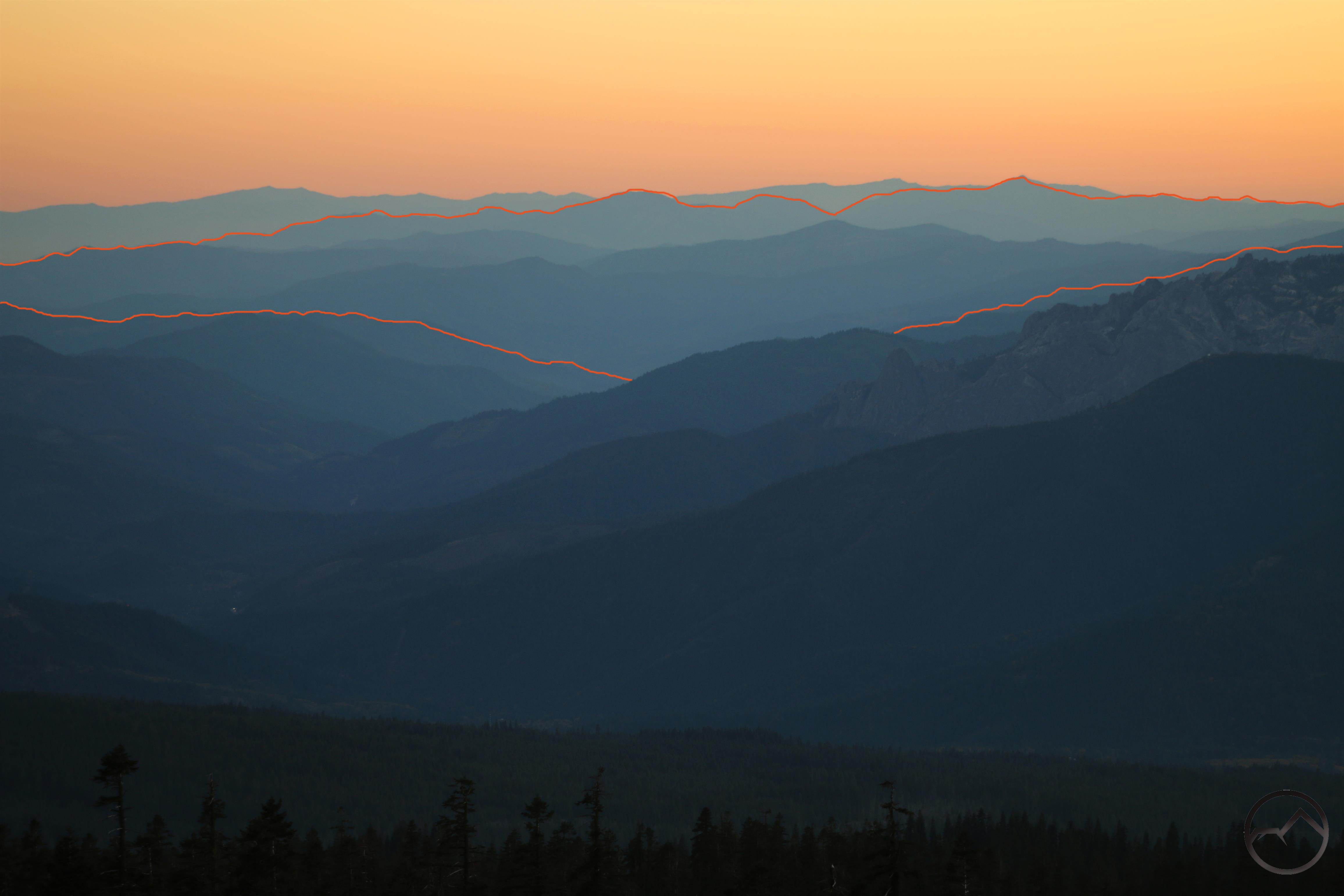
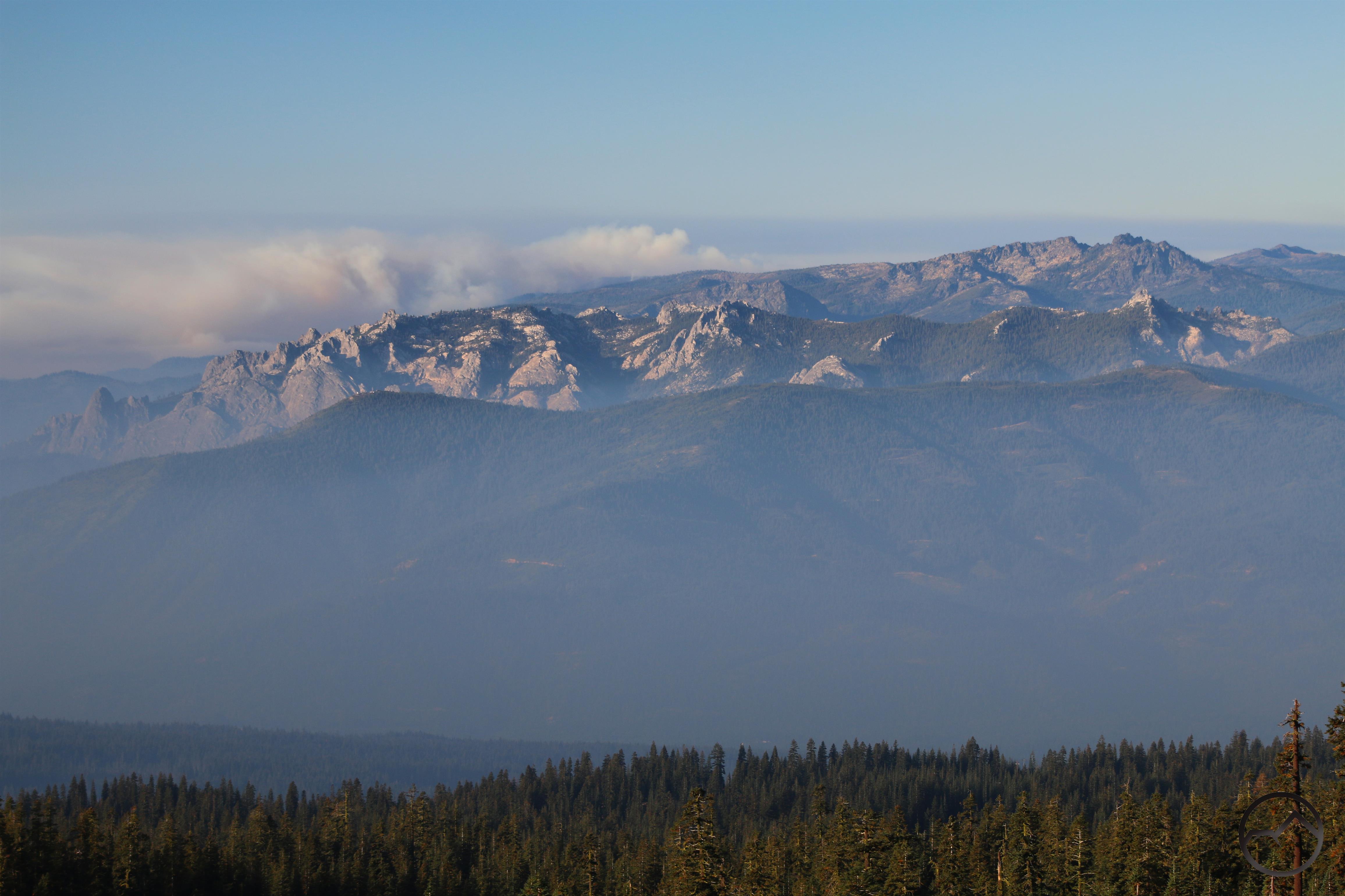
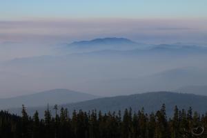
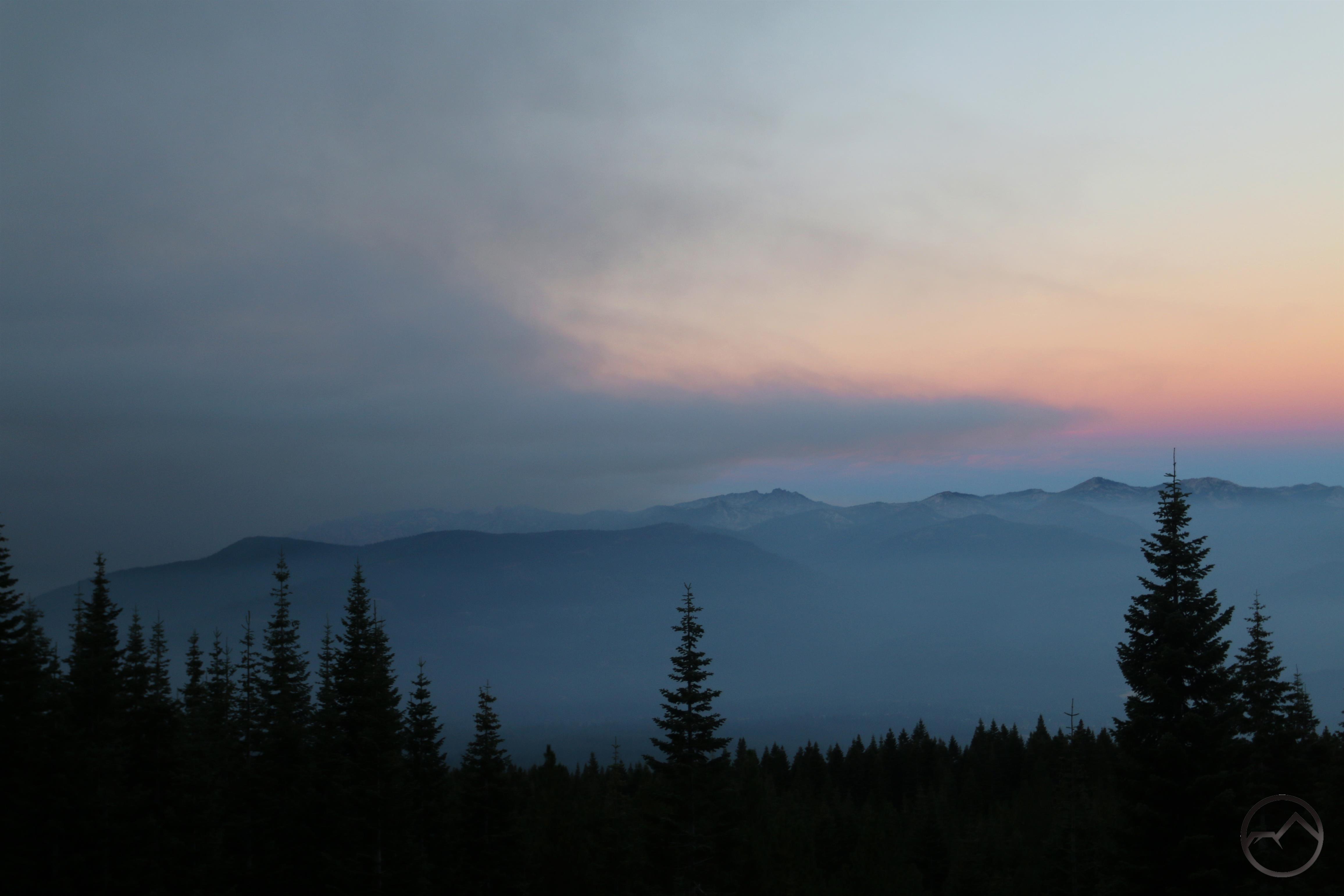
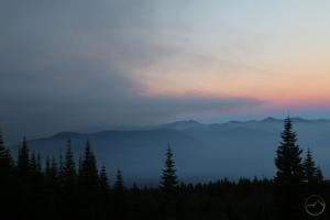
The magnificent view south, from the Old Ski Bowl.
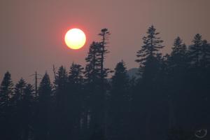
Last weekend, after leading the Cub Scouts on a hike through Panther Meadow, we headed up to the Old Ski Bowl to watch the sun set, drink hot chocolate and enjoy the spectacular scenery. It was spectacular as always but it was made even better by the thin layers of smoke from the still smoldering fires. The slight haze allowed each layer of the mountains to be highlighted. Even better, it caused the color gradient in the sky to be especially dramatic.
While everyone was drinking their hot chocolate, staying warm and enjoying the scenery, a ran up to the edge of the Old Ski Bowl’s picnic area, set up my tripod and captured this fantastic shot of the mountains. Two thoughts occurred to me while standing there. First, this complex tangle of mountains was what I believe John Muir was referring to when he said this:
“When I first caught sight of it over the braided folds of the Sacramento Valley, I was fifty miles away and afoot, alone and weary. Yet all my blood turned to wine, and I have not been weary since.”
These are braided folds indeed.
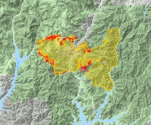
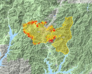
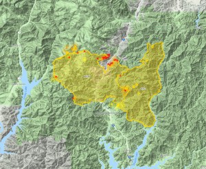
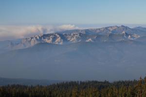
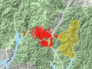
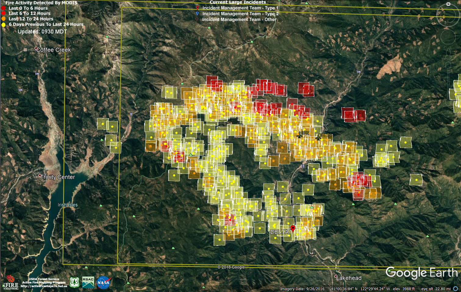
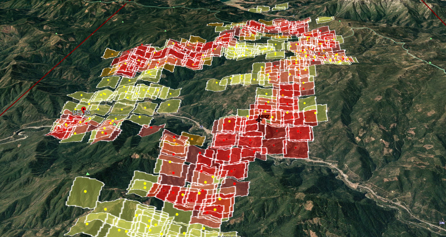
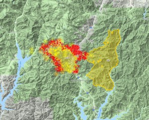
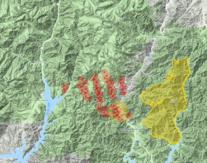
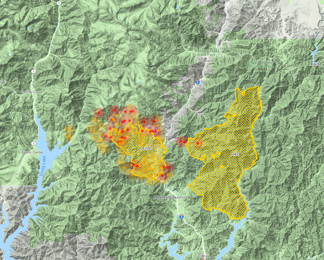
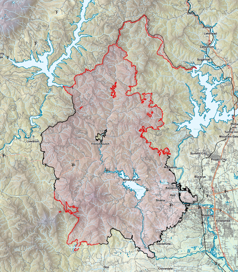
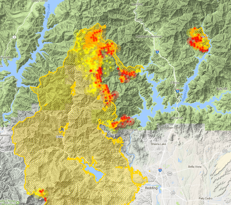
The second thought that occurred to me was that most of this area burned this summer, between the Carr, Hirz and Delta Fires. You can see the burned area (part of it, at least) below, highlighted by the orange line:
It may only look like a sliver of the image but it is a bit deceiving. The zoom lens compresses the image, making the area appear smaller than it is. In truth, the area within the lines covers a distance of over 40 miles from north to south. It is stunning that so much territory burned.
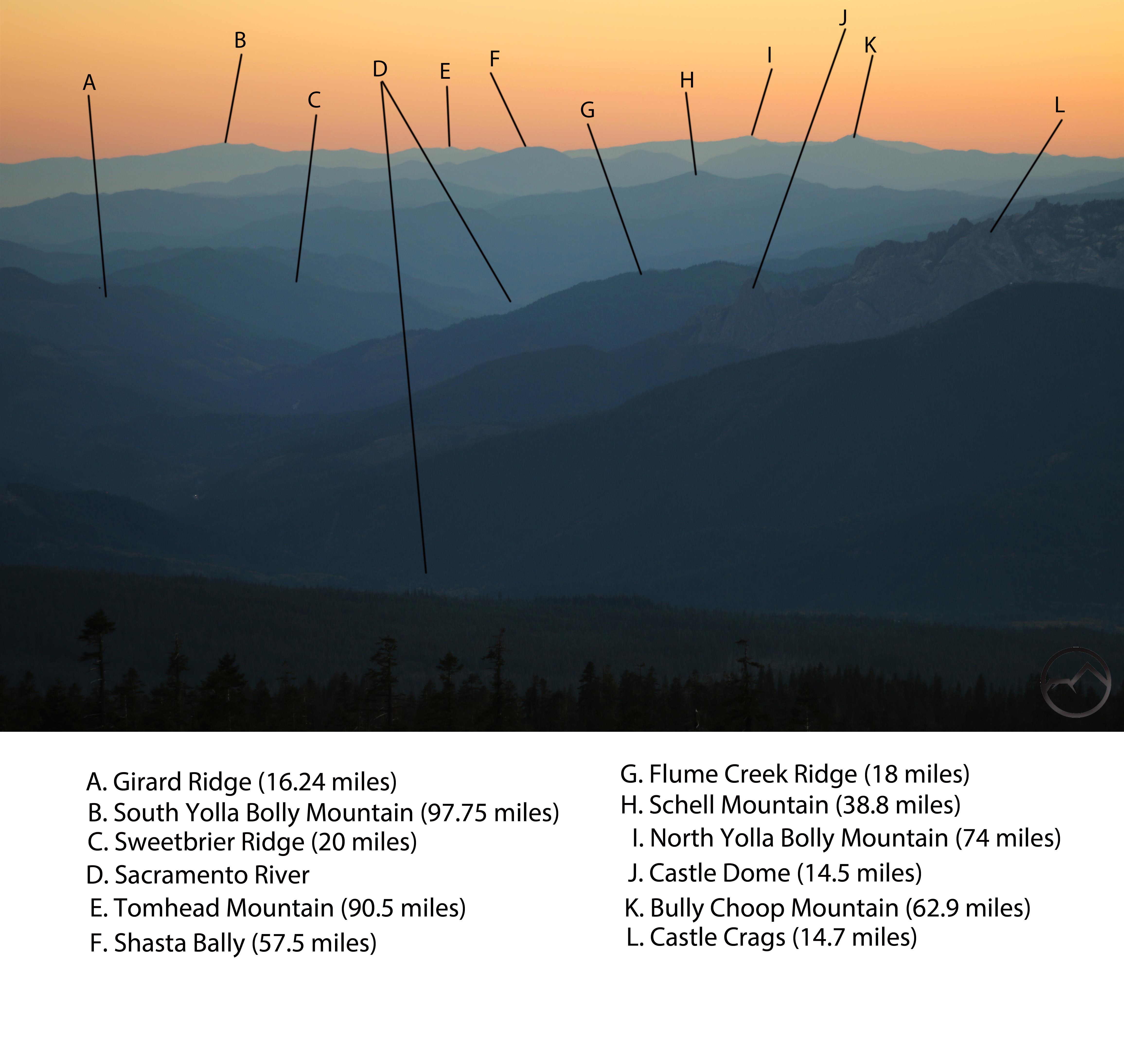
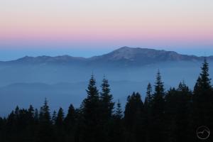
In spite of the destruction, the region remains beautiful and vistas from Mount Shasta like this one remain tremendous. The views from this spot reach further than just about anywhere else in California reachable by car. I may be wrong about that but if there are accessible vistas that reach further than this I’d like to know what they are. Worth noting, Snow Mountain was visible 135 miles to the south, but was out of frame in this image. To give some context to the image and to help give context to the image, I identified many of the landmarks and listed how far away they are from the Old Ski Bowl.
We are blessed that, in spite of the destruction, this is still a beautiful and remarkable world!
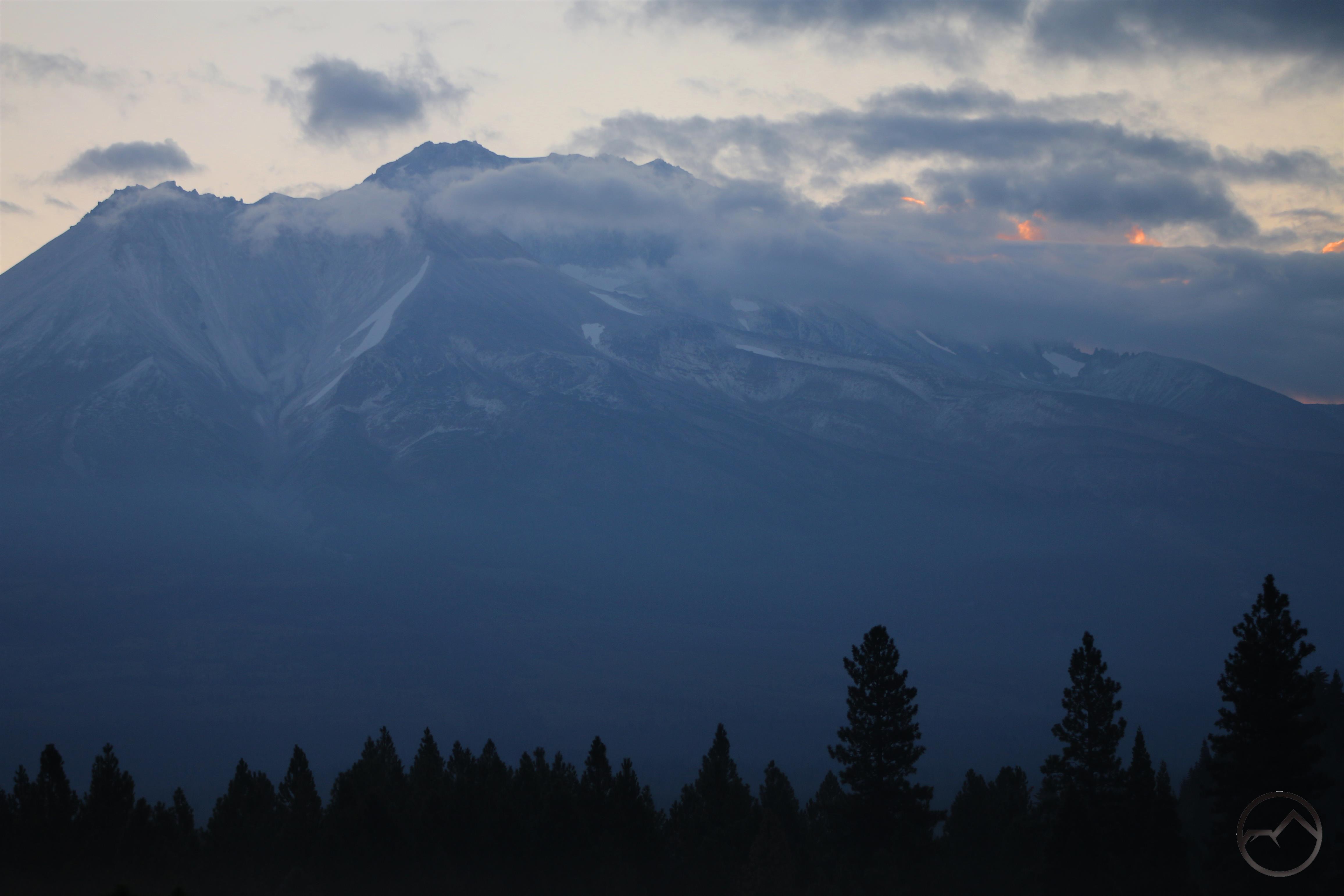
Mount Shasta received a late summer dusting of snow.
More than a week into the Delta Fire, the firefighting effort has really turned a corner on containing the beast. Officially, the fire is at 17% containment. While it has grown 58,427 acres, it has not jumped any fire lines and the areas that have been burned recently were within the projected fire lines. Not only has the pace of containment accelerated, the growth of the fire has decelerated. This is largely the result of cooler temperatures and even a little precipitation. Though there is no more rain in the immediate forecast, what little we did get was a huge blessing. It suppressed fire activity and allowed firefighters to really advance the containment lines. As a welcome harbinger of these successes, Mount Shasta even got a light dusting of snow during the night!
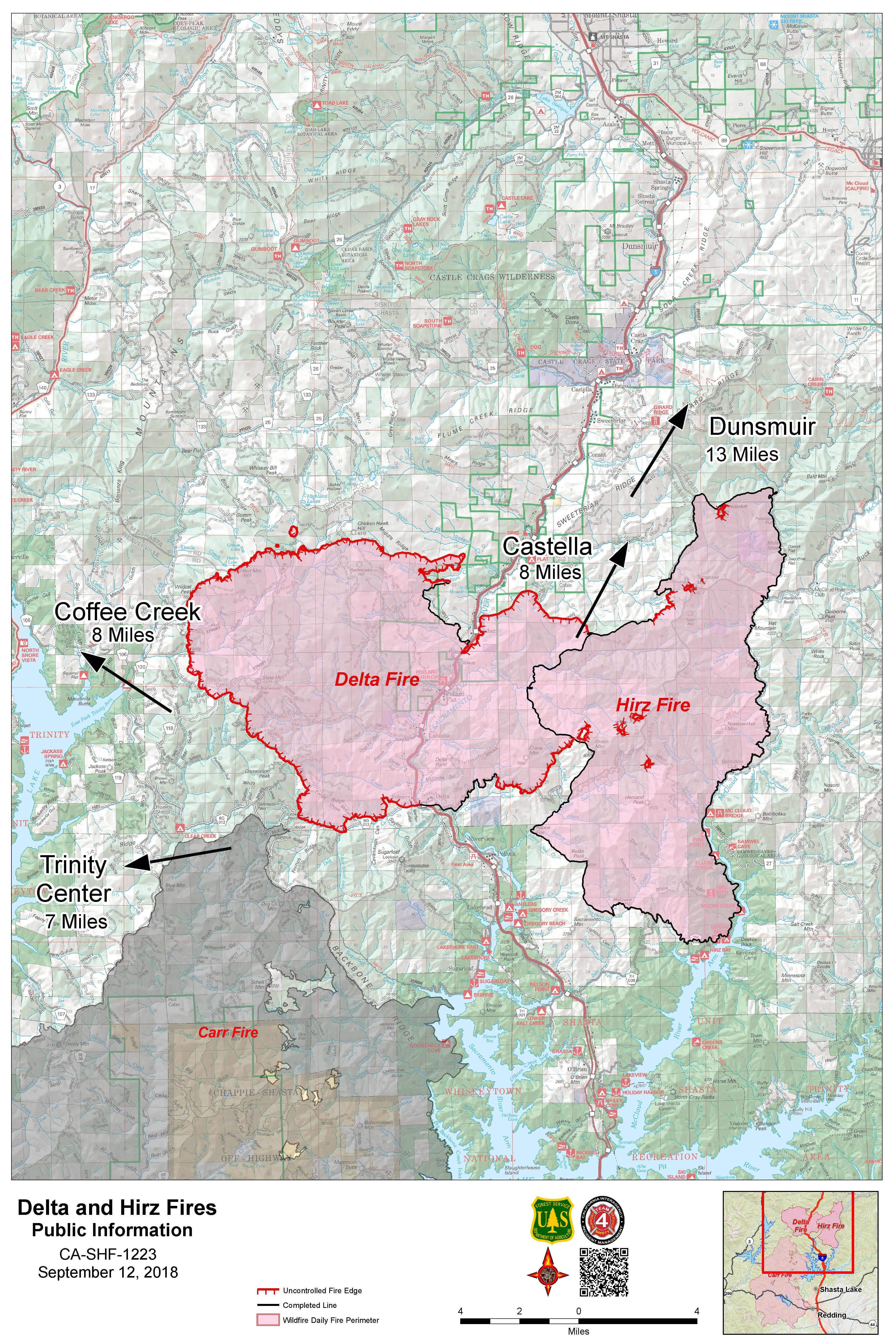
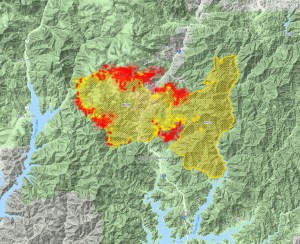
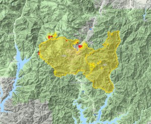
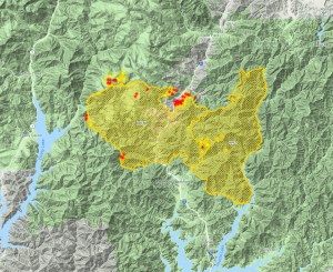
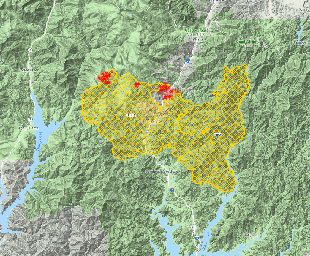
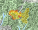
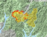
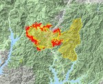
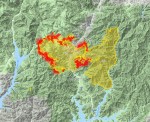
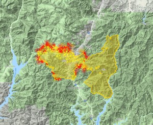
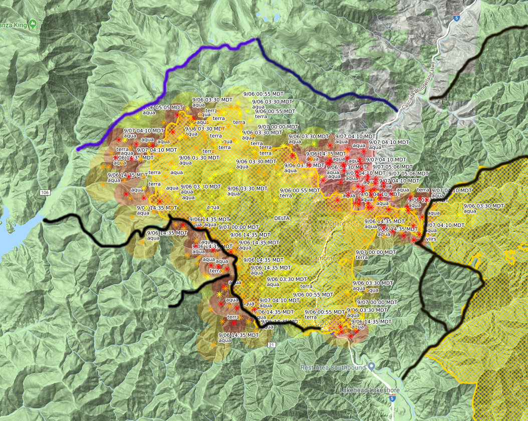
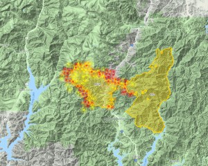
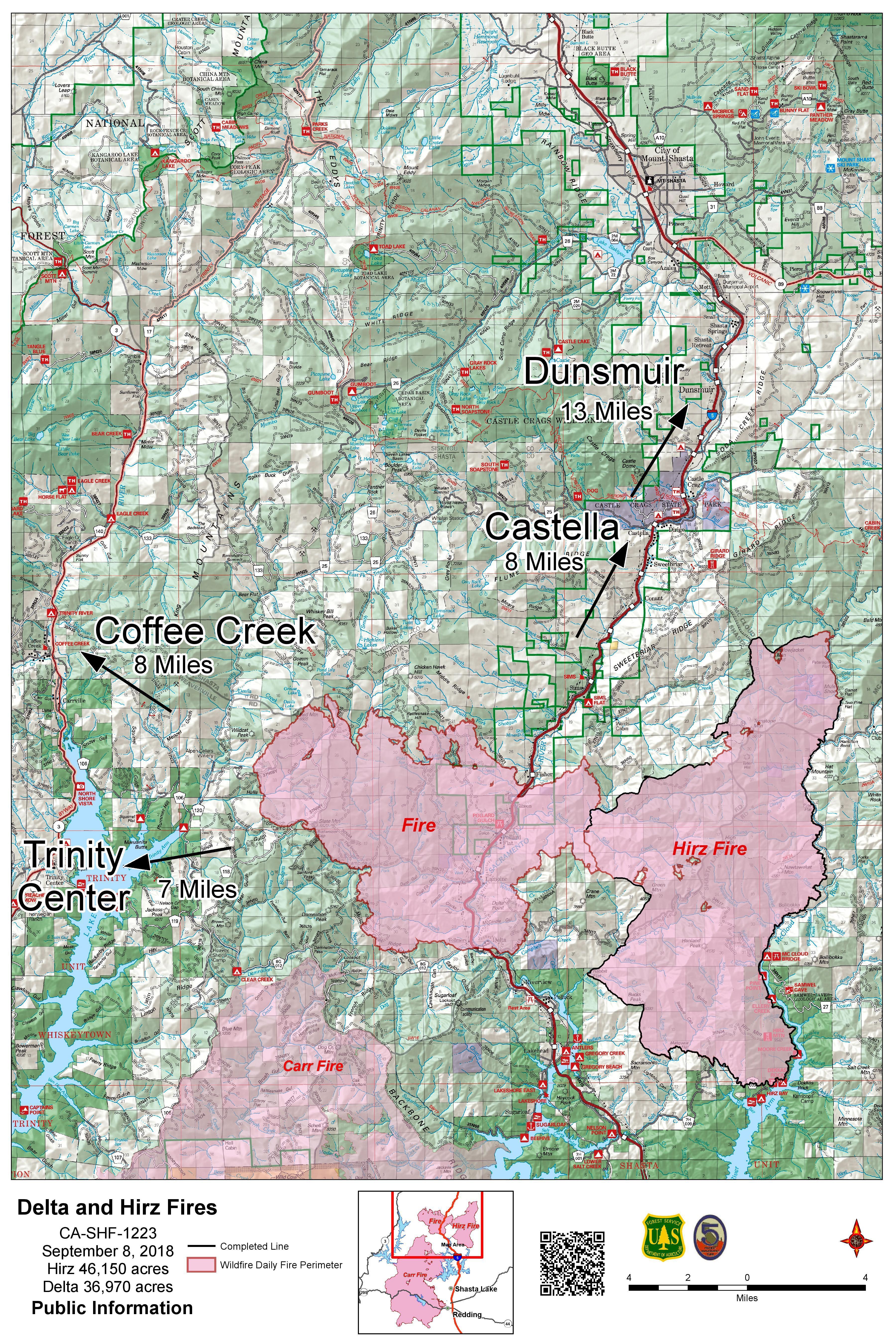
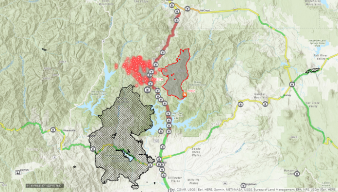
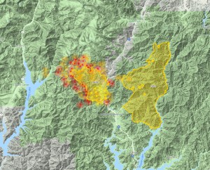
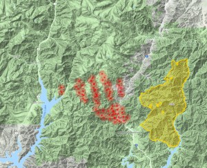
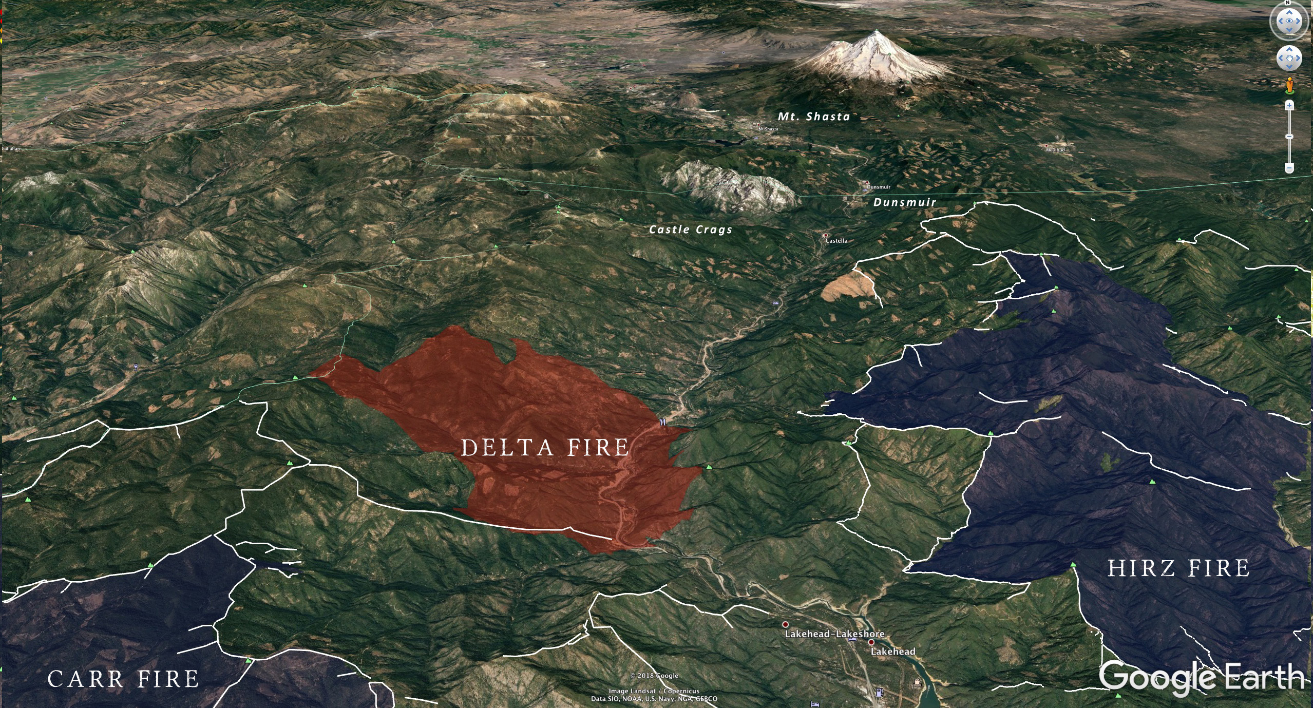
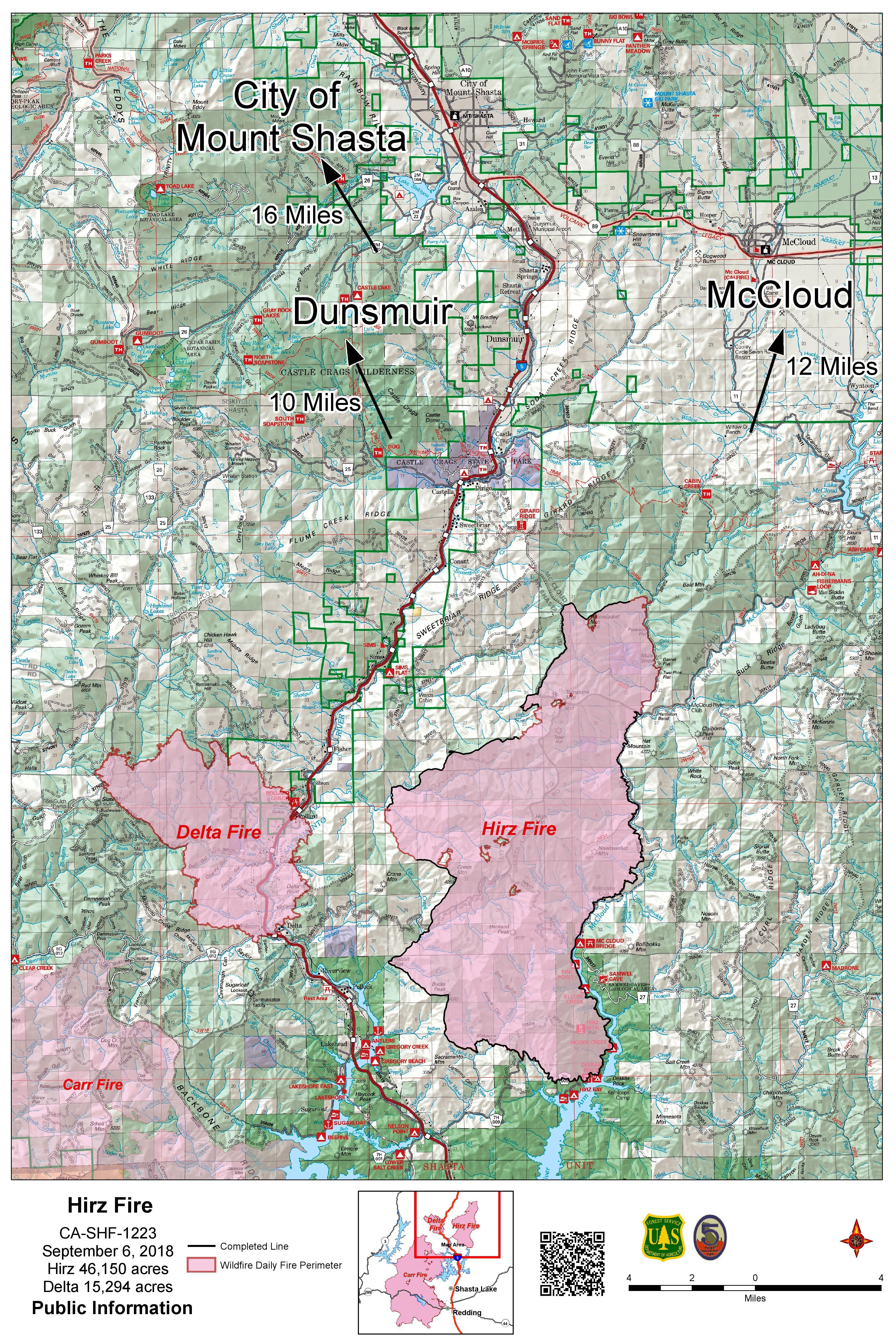
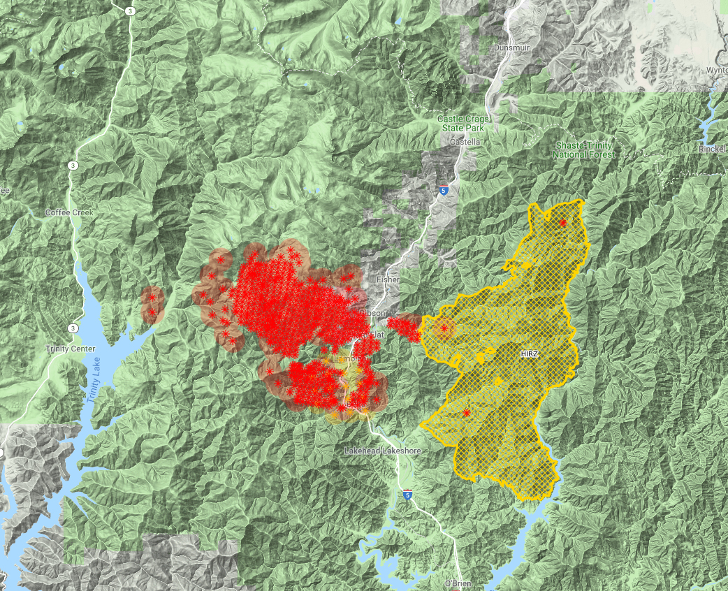
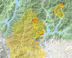
The Delta and Hirz Fires as of September 12.
Though the Delta Fire is officially larger than the adjacent Hirz, the two have completely merged together, forming a single block of burned terrain that is over 100,000 acres. The Hirz is 100% contained, so its containment lines help hold back the Delta Fire and have allowed firefighters to deploy resources in more pressing places. This has also been true on the south, where contingency lines built to hold back the Carr Fire, should the fire have jumped the main containment line, were also critical in holding the Delta Fire back from a southward advance.
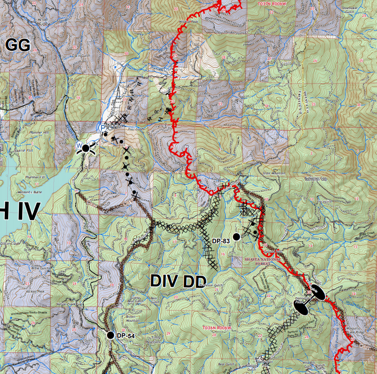
The really encouraging work has taken place on the north side of the fire. Not only was the Highland Springs community saved, but the containment lines further north have been constructed. This means that the Tamarack Lake Basin is likely to be saved. As an added bonus, the rarely visited Highland Lakes, Pond Lily Lake and even possibly the Grouse Lake basins will all be outside the fire’s ultimate boundary. This also means the Grey Rocks, some of the most rugged and enigmatic peaks in the region will not be burnt over as well. This is great news for hikers, explorers and lovers of the natural world. Also, it means that the communities further up the Sacramento River Canyon are not going to be threatened by the fire.
Progress is also being made on the west side of the fire. Some of the Carr Fire’s contingency lines are in use The terrain here is steep and rocky in some places. Lately, it has been the focus of consistent aerial attack. Fire lines have also been under construction as well. This area is critical, since there are some residences and even an extensive vineyard here along the East Fork of the Trinity River. While this area is still threatening, it is not as urgently dangerous as it was a week ago. Progress is definitely being made. Even though the low temperatures of the last few days and nights are not going to be sustained, the daily highs will only reach into the 70’s, meaning there are better conditions for fighting the fires.
The good conditions and increasing containment mean that the worst of the Delta Fire is likely in the past and we can hopefully look forward to a pleasant end to the summer months and a beautiful fall. Let us pray the fires are left behind as well.
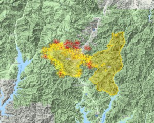
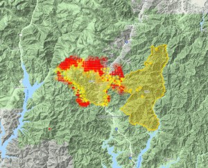
Here is a gallery of Delta Fire activity from the last three days. Click to enlarge:
Sept. 10 8:00 PM
11:00 PM
Sept. 11 7:00 AM
5:45 PM
8:40 PM
Sept. 12 12:00 PM
5:30 PM
8:00 PM
Sept. 13 7:00 AM
8:30 AM
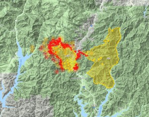
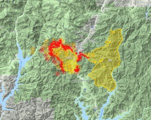
Update(5:30 PM):
Of course I had to write a post about turning a corner on the fire. It’s only after that that the fire flares up and necessitates I-5 being shut down once again. The fire has increased activity around the Gibson exit. Other than a spot up on Red Mountain in the northwest, the rest of the fire looks fairly quiet but the increase of activity in the canyon is troubling. Here is how it looks:
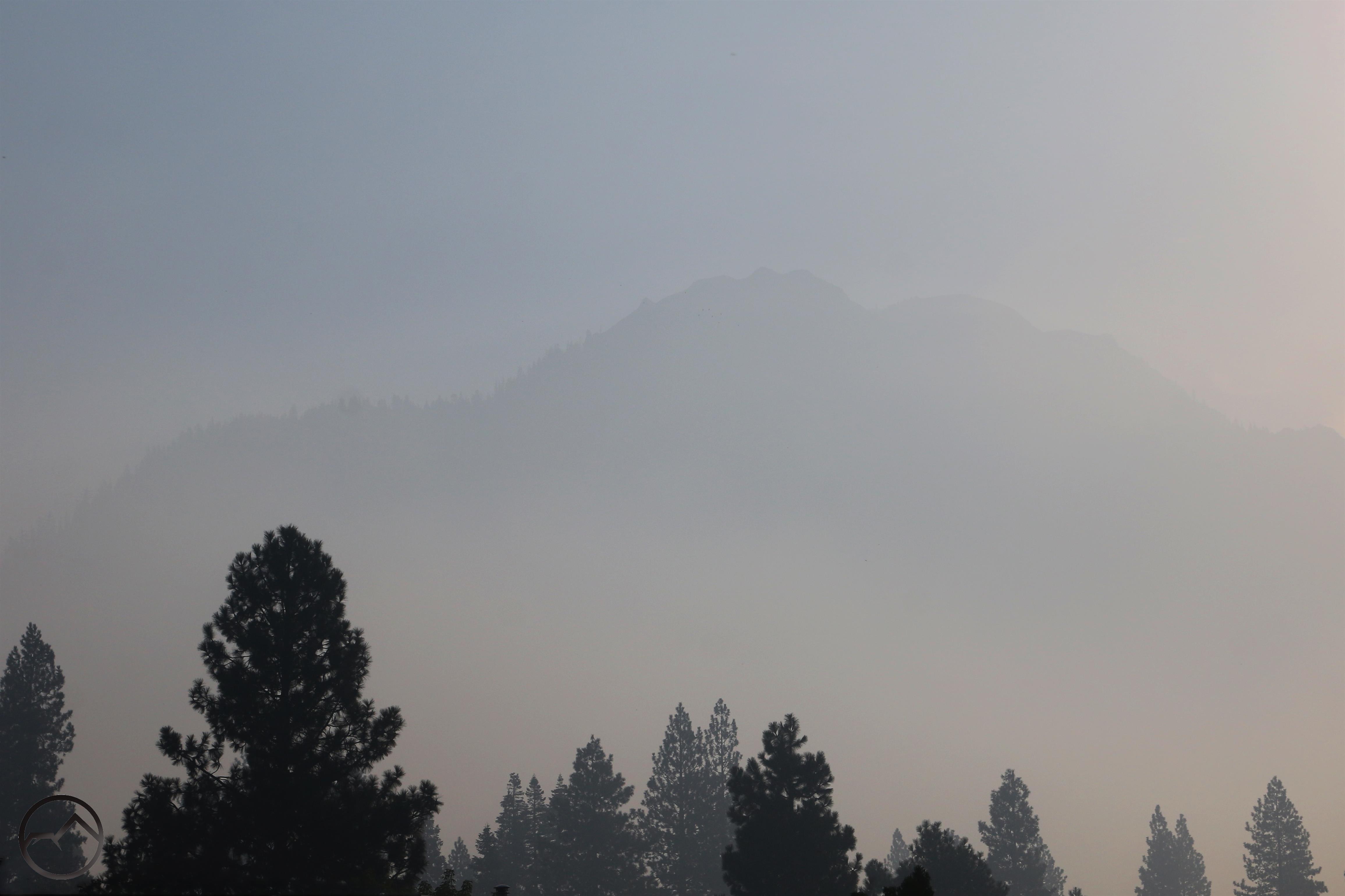
Without even knowing the fire had kicked up again and that I-5 was closed, it was obvious here in Mount Shasta that something was afoot. After good air quality over the last few days, the smoke rolled back into town in a big way. No doubt this is the result in the fire getting more active again. Thankfully, despite the seriousness of the flare up, it is a pretty localized event. Hopefully they will be able to put a lid on it pretty quick.
The smoke it back yet again. Hopefully it will blow out soon.
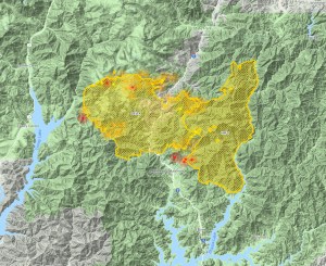
The Delta fire burns south of Flume Creek Ridge, the Castle Crags, the Grey Rocks and Red Mountain.
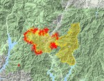
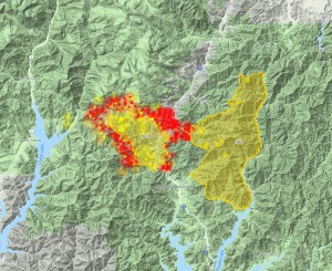
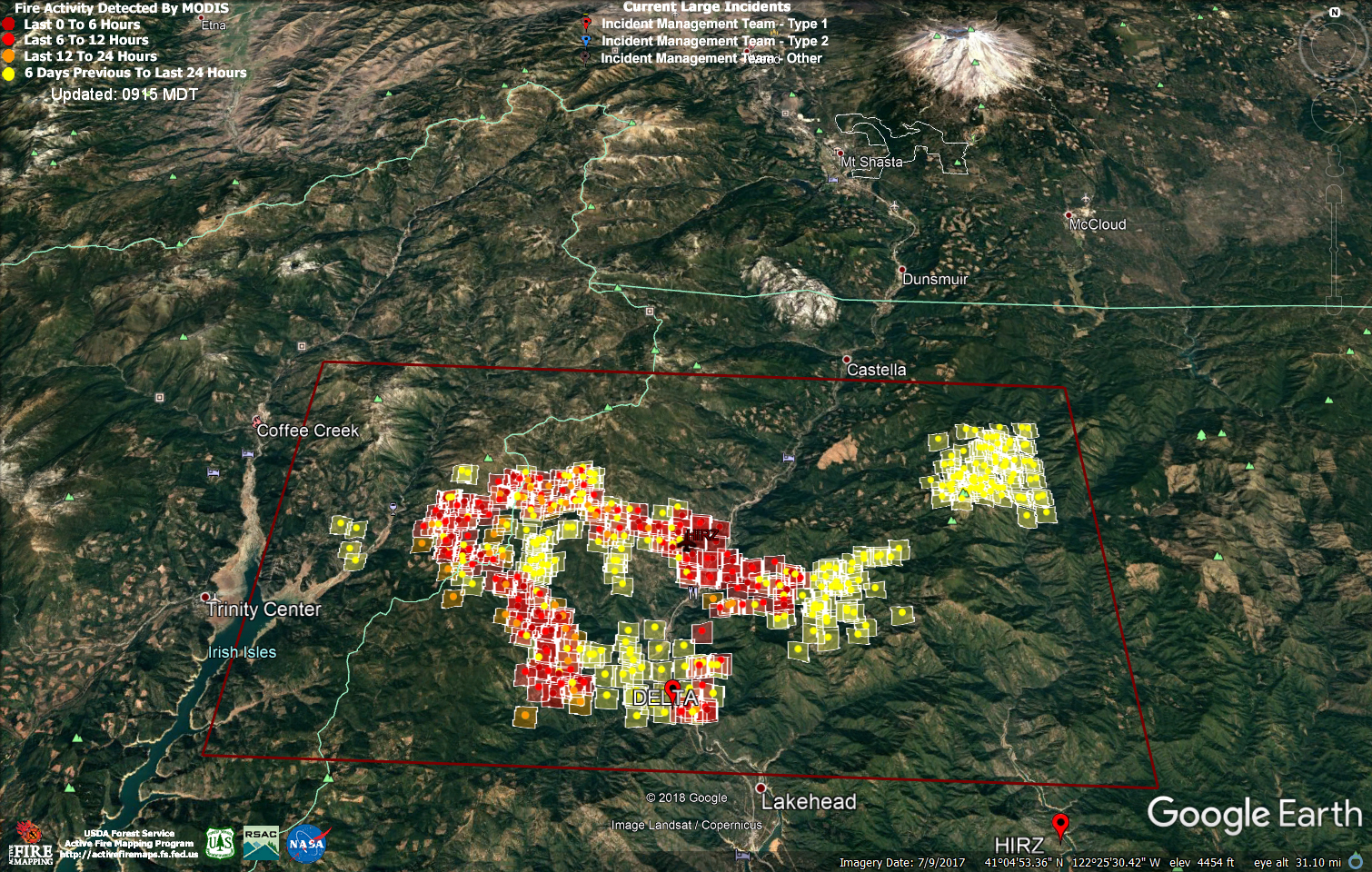
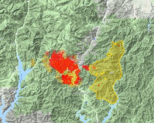
We have reached day 6 of the Delta Fire. It has now grown to 47,110 acres, making it roughly 1,000 acres larger than the now-contiguous Hirz Fire. Fortunately the fire has continued a slow advance it is now officially at 5% containment. I believe that the functional containment is actually much higher, considering the use of contingency line left from the Carr and Hirz Fires as well as the burned out areas of the Hirz, where there is little fuel left for the Delta to expand into. Nonetheless, the northwest side of the fire remains uncontrolled and continues its slow but inexorable advance up the Slate Creek drainage.
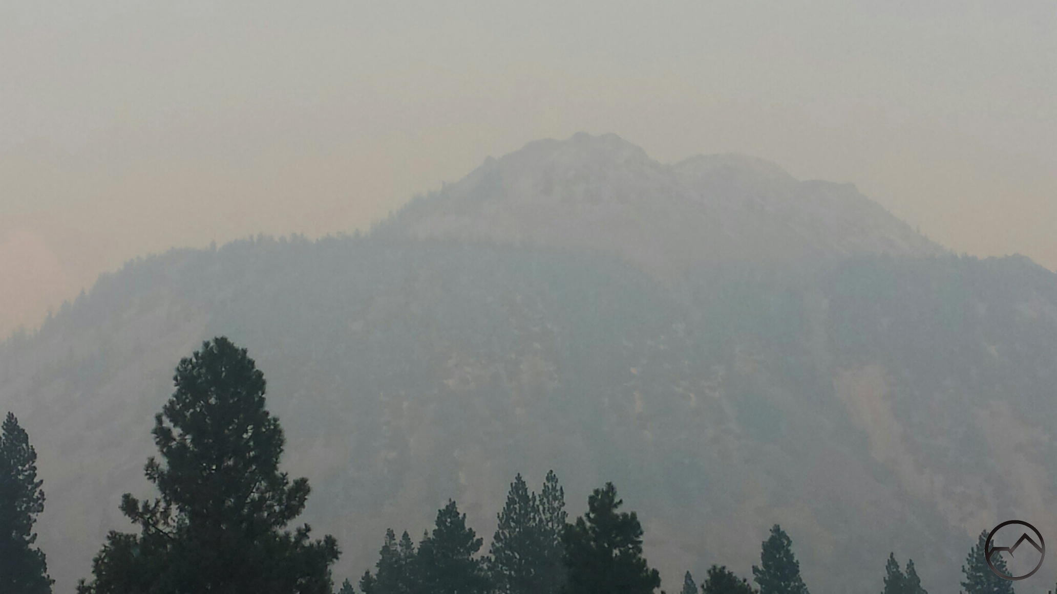
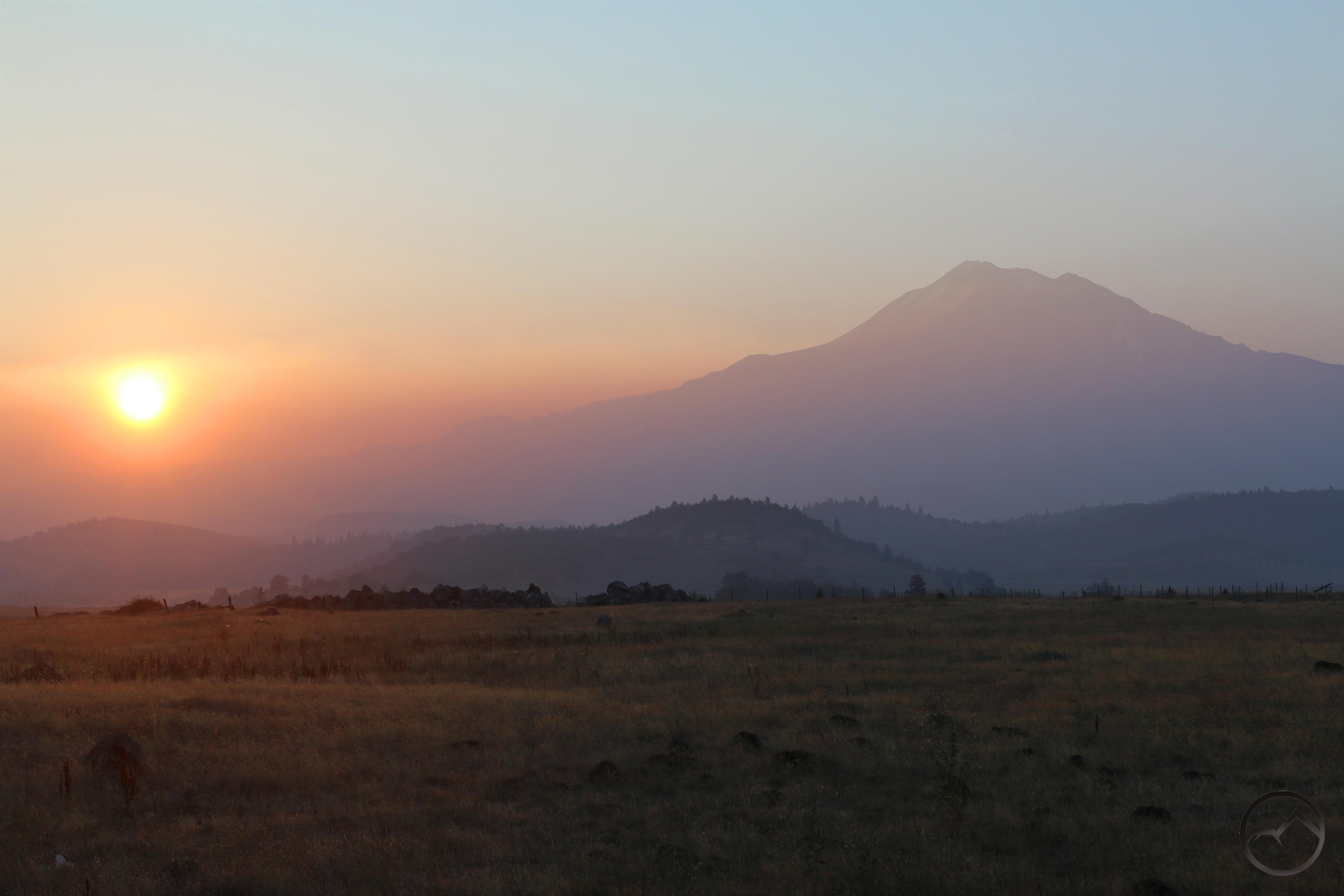
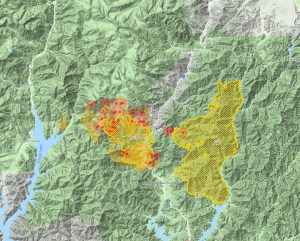
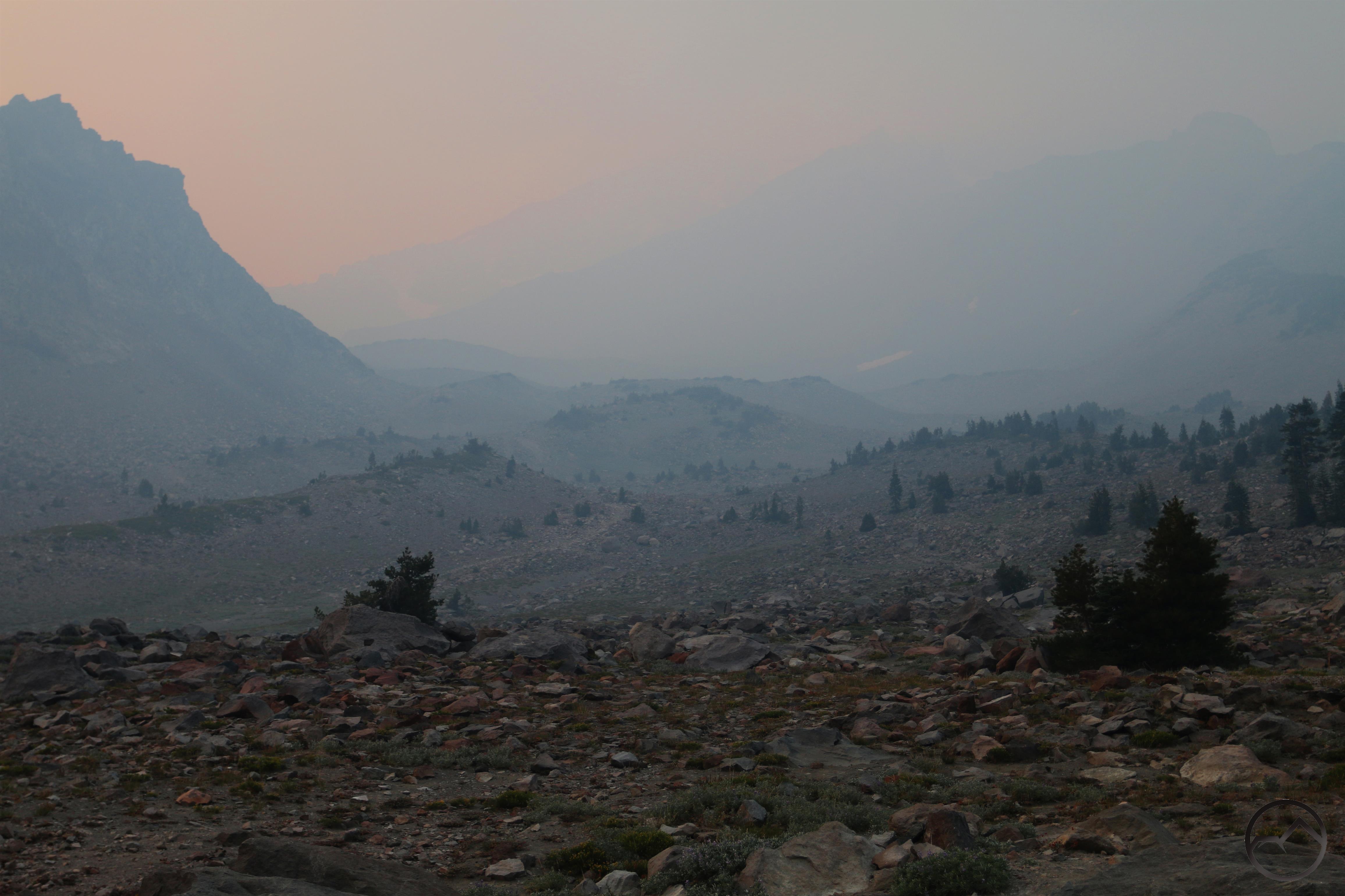
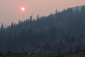
The smoke was awful yesterday but after the sun set the winds cleared it out in fairly swift fashion, leaving a night of clear stars. This morning was clear as well and, seeing some interesting clouds and minimal haze, I headed out to see what conditions were like. It made for a beautiful sunrise and lovely conditions up at the Old Ski Bowl.
The good air quality at the Old Ski Bowl also meant I had a good opportunity to look south and observe the Delta Fire’s activity. The sky was haze free all the way to the plumes that were coming up from the northern part of the fire. All the smoke was blowing east. Strangely enough, though Red Mountain is right at the front line of one of the most active parts of the fire, the wind made it seem as though there was no smoke in that vicinity at all. It also meant that the area burned by the Hirz Fire was totally blanketed in a deep layer of smoke.
Tombstone Mountain rises above the smoke in the Hirz Fire area.
Beyond Castle Dome and the Castle Crags, smoke billows up from the Delta Fire.
This raises the question about what is going on with the Delta Fire at this time. Thankfully there are positive developments. First, as noted, there is some official containment of the fire, though the functional containment is probably significantly higher than the listed 5%. Anything is good at this point, though. Second, also as noted, the fire continues to advance but only slowly. Though it is troubling that it has reached the area around Red Mountain, I am hopeful that the rugged, rocky terrain will function as a natural fire line and keep the flames from advancing north and west from there.
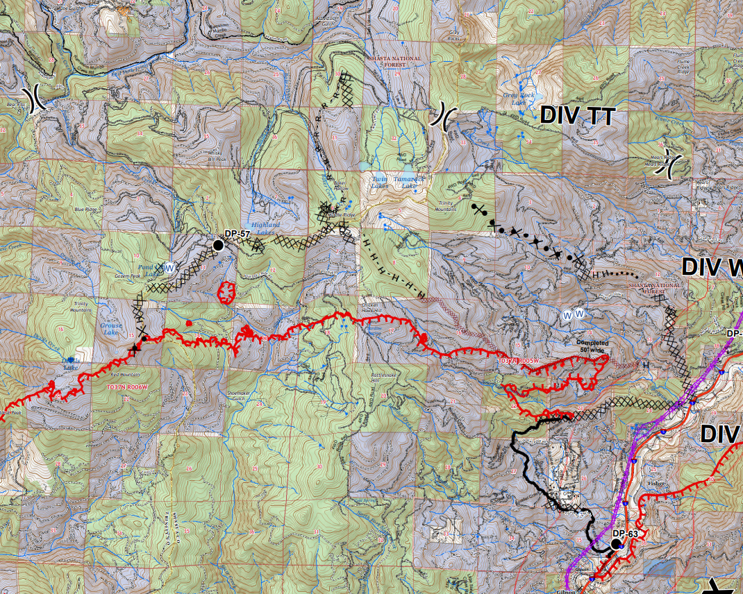
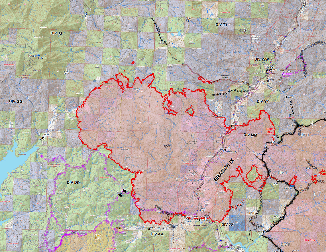
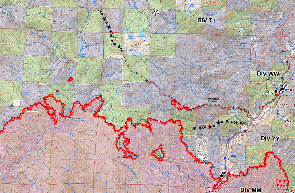
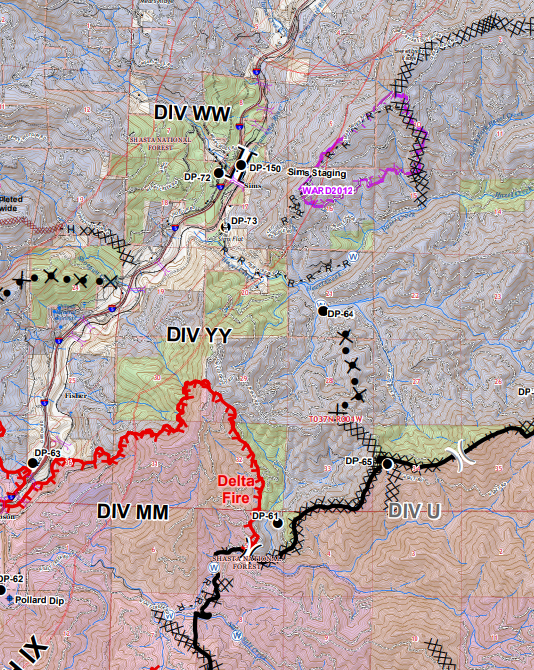
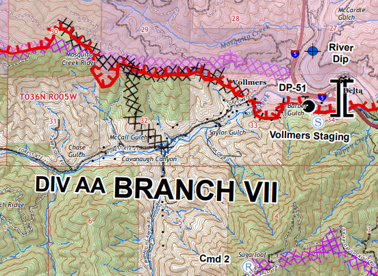
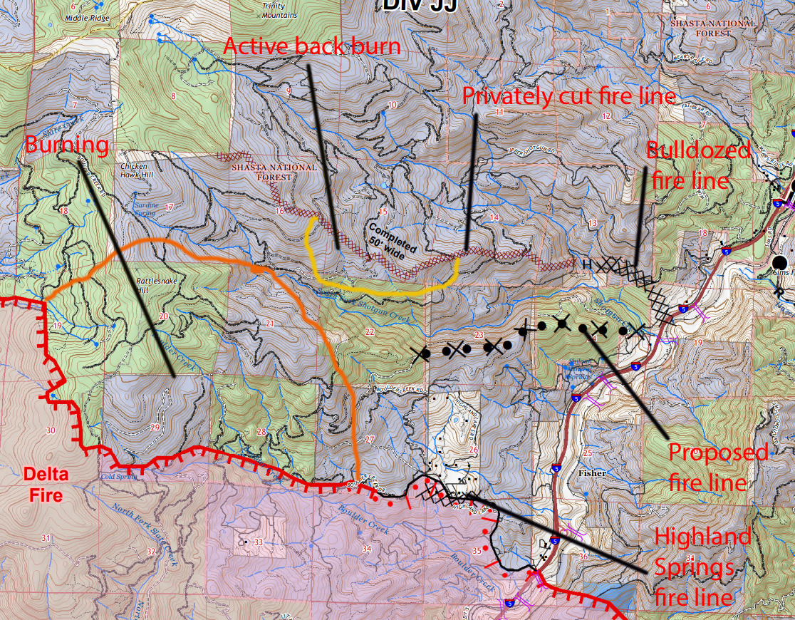
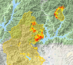
Also good news is the ongoing and increasing back fire activity on Middle Ridge. This is the critical line that must be held, since this stands in the way of the route the fire must take in order to burn up the Sacramento River canyon and threaten all the communities that lie to the north. The good news is not limited to the back firing though. Crews have been working hard cutting in a hand line on the upper part of Middle Ridge. here the terrain is rockier and bulldozers are not likely to be useful. However, amidst the rocks, the vegetation is sparser and crews can clear that into a solid, defensible hand line. The map below give a clearer picture of this:
Note the line of ‘H’s’ extending north of the established fire line. This extends all the way to Baker Peak, which is one of the highest points along the ridge above Tamarack Lake.
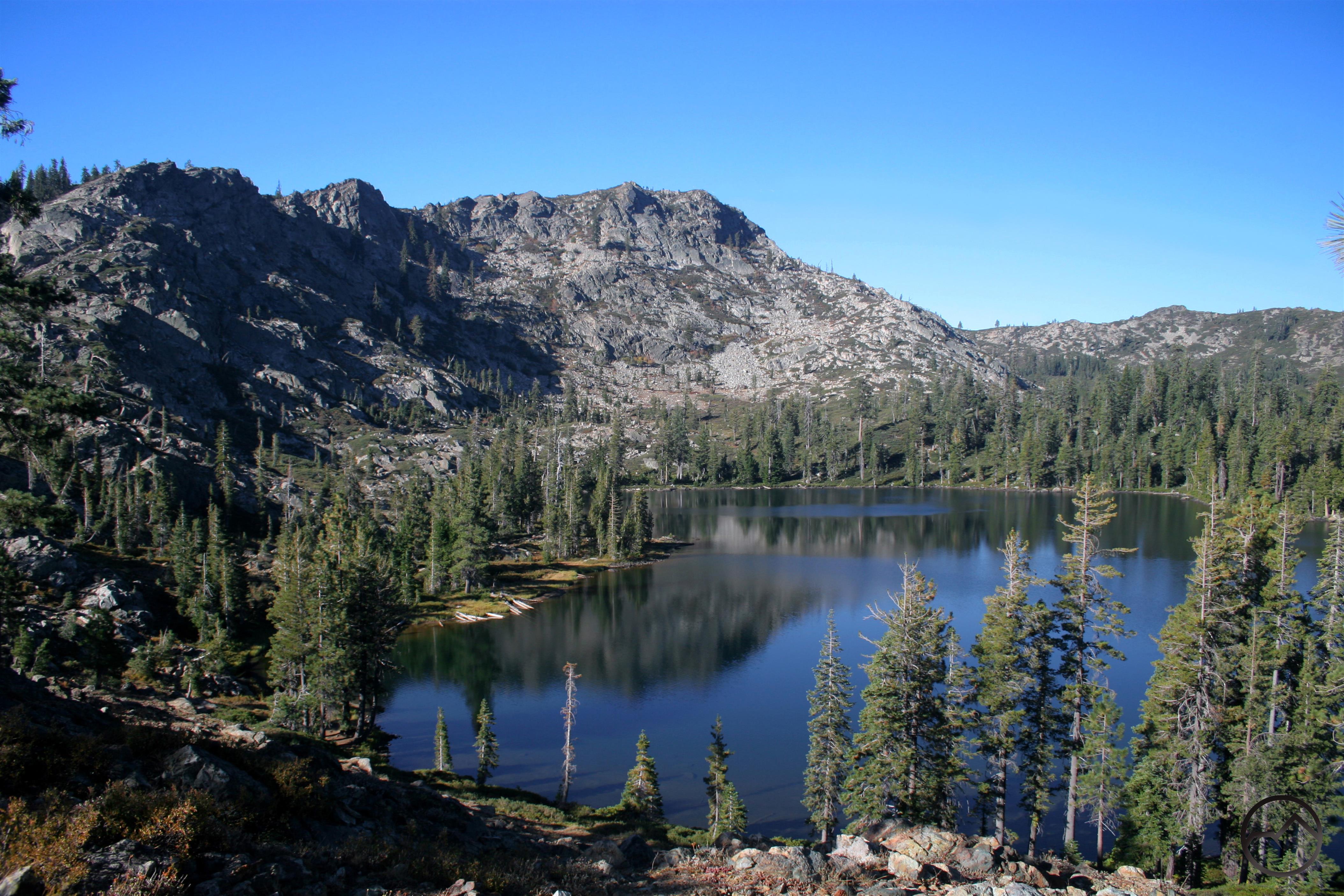
Tamarack Lake
Also important is the indication of a bulldozer line being prepared (marked by X’s and dots) further north, in Baker Hollow. I am really glad to say that, if these lines hold, it is highly likely that the Tamarack Lake basin will be spared! I can’t express how relieved I am that this may even be a real possibility. The Tamarack Lake Basin is one of the prettiest in the entire Klamath Mountains, with its rugged cliffs, gorgeous lakes, lush meadows and views of the craggy Grey Rocks all combining to make a very idyllic spot. While it is by no means guaranteed at this point, the fact that the line are being cut in in such a way that the fire might get saved is encouraging.
On the east side of the fire, the flames have expanded on into the burned out area left from the Hirz Fire. Fortunately, the old fire lines and the burned areas will keep the fires in check. The most vulnerable area is the Hazel Creek watershed, which meets the Sacramento River at Sims.
According to the above map, it does look as though containment lines are in place and under construction that will prevent the whole Hazel Creek drainage from going up in smoke. I am also encouraged that saving this area is even a possibility. I hope the efforts prove successful.
It is worth noting that the Union Pacific has been running a firefighting train through the canyon, spraying down the trees along the tracks and helping prevent it from burning. This has also allowed them to maintain the rail corridor through the canyon. This idea is affirmed by the testimony of trains that continue to fly past my house. As far as I-5, it is now open one lane in each direction.
In summary, the fire is still large, still advancing but significant gains have been made and some special places may be spared destruction. I hope this will be the case when it is all over. Now if we can just get some rain!
Click to enlarge the last couple days worth of fire activity:
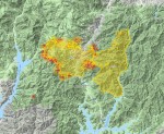
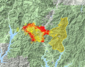
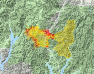
With the Delta Fire still raging through the Slate Creek watershed and growing to a depressing 40,580 acres, I thought it might be helpful to look at some positive developments going on with containing the fire. I want to admonish that all of what I have to say is from my own observation and interpretation of the maps. All the maps are available to the public, though some may be harder to ferret out. I apologize for any mistakes or misinterpretation of the data.
That said, the first thing I want to point out is that though the fire continues to grow, its pace has slowed, giving the firefighters a window to get some assets in place and try to slow the advance. Looking at the fire on Thursday morning compared to this evening is a little reassuring.
Sept. 6 7:00 AM
7:00 PM
Obviously the fire is larger than we would like, but when I went to bed Wednesday night I was expecting things to be far worse on Thursday. Moreover, I figured the fire would have consumed Tamarack Lake by this point and moved further up the Sacramento River canyon as well. As of Saturday night, neither of those two things have happened yet. Both could still be lost to the fire but at least at this point there is a fighting chance to save them and hope yet remains.
Another big blessing was the fact the the Delta Fire erupted in between the Hirz and Carr Fires. That meant that assets were close at hand and, just as important, many fire lines had already been cut. These were contingency lines to contain the Carr and Hirz if they jumped the lines that ultimately checked them. Nonetheless, they could swiftly be manned and brought into play to protect structures and unburned terrain.
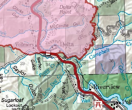
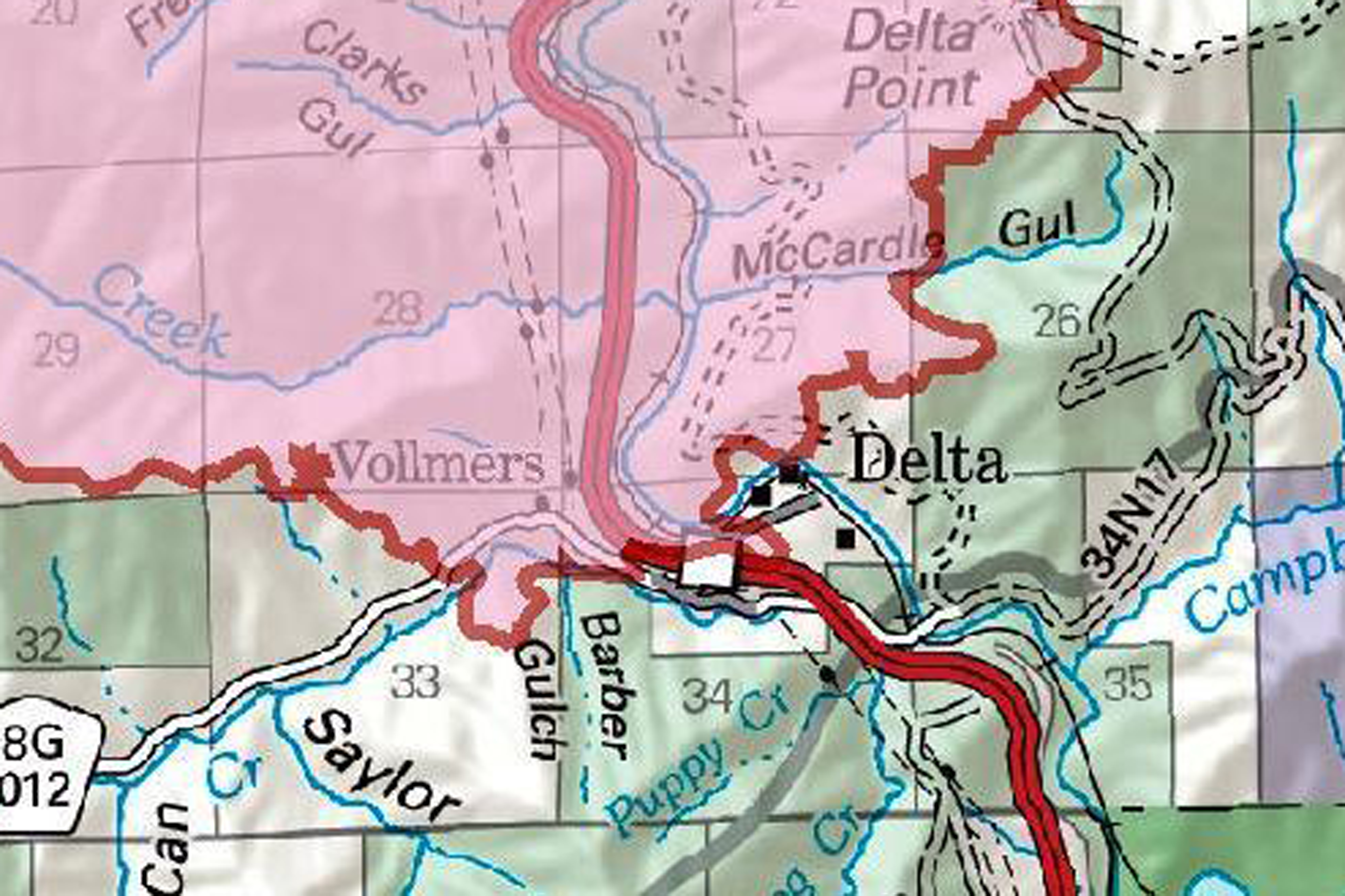
One good example of this was at Vollmers, where most of the homes seemed to have been saved. The contingency line for the Carr held the Delta Fire back.
The purple ‘x’ line is a Carr Fire contingency line. The black ‘x’ line is new fire line cut in to fight the Delta Fire.
The lines at Vollmers have been strengthened but and most of the canyon is outside the fire’s perimeter. That would likely not be the case if the contingency lines were not already in place. Unfortunately, the nearby hamlet of Delta has now fallen within the fire’s perimeter, where it had been excluded before. At this point, the fate of the homes is uncertain. Let’s hope they are still there.
Delta now inside the fire’s lines.
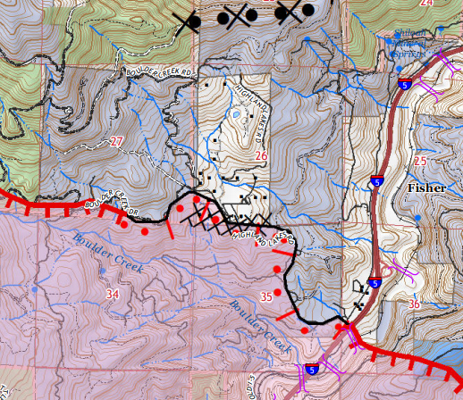
Another place where firefighters have made a valiant stand is to protect the homes in the secluded neighborhood of Highland Springs. This collection of houses lies in a hidden area on the west side of the canyon. A fire line was quickly cut in on the south side of the area and, thus far, has managed to hold the flames back. It isn’t exactly containment but it is a significant victory.
Highland Springs if the light colored block above the black ‘x’ line, which notes a fire bulldozed fire line.
The Highland Springs area is part of a really active firefighting area. This is the most critical part of the containment operation at this time. Holding the fire where it is right now will prevent the fire from advancing up the Sacramento River canyon and threatening Sims, Sweetbriar, Castella and Dunsmuir. I reckon this is where a lot of resources are being thrown into the fray.
The above map gives a broader picture of some of the firefighting operations that are currently ongoing. There is already a usable fire line cut along Middle Ridge. I believe that back burning operations have already begun there. Not only does this help hold back the fire from heading toward more populated areas, it also helps defend natural places like Tamarack Lake. The rest of the ridge running to west is still vulnerable. Hopefully this is the next area targeted for attack.
We’ll have to see what the fire does tonight before being able to guess what the next stage of containing the Delta Fire looks like. I think there is some factors that give some flickers of optimism at this time. Nonetheless, the situation is still very fluid and the whole effort could go sideways. Let us pray that proves not to be the case.
The sun rises through smoke that covers the region east of Mount Shasta.
Today is the fourth day of the Delta Fire. While the fire began with a roar on Wednesday, it seems like its advance has slowed, though it is still out of control and very dangerous. This morning it has heated up again and is moving north.
Yesterday was pretty smoky but when I awoke this morning I saw stars and new I needed to head out to see what I could see. Though the town of Mount Shasta was clear, I could tell as I drove up Everitt Memorial Highway that the smoke coming from the fire was thick and was really starting to encroach on the Old Ski Bowl, making a good view of the fire unlikely from that vantage point. Fortunately, the Everitt Vista Point was far enough west it offered a good perspective on the fire, as well as the smoke down in the valley below:
From there I headed north, to watch the sun come up behind the mountain. With the smoke drifting to the northeast, the morning provided a the unusual spectacle of watching the sun with the naked eye, as it was filtered by the smoke. Also unusual was the smoke passing through the gap between Mount Shasta’s summit and Shastina. The smoke seemed to flow faster through the gap, pushed by the strong wind currents that are typical of that spot. I watched the plume as it billowed and roiled and thought it almost looked as though fresh snow were being blown off the mountain as the sun was coming up. Would that it were so.
The smoke may present some unusual photographic opportunities but at this point I would dispense with them for a dead fire and clear skies.
Before I go into what the fire is up to, I want to reiterate that all the analysis is my own and that I am a complete amateur at this. Firefighting personnel know far more than I!
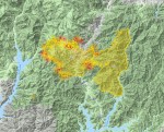
So what is going on with the fire this morning? Frustratingly, it has now grown to 37,000 acres, nearly equaling the neighboring (and now contiguous) Hirz Fire. Yesterday the fire expanded a bit in the canyon, threatening to move north through the vital and vulnerable corridor. Thankfully it seems to have backed off there. However, there is renewed strength to the flames on the northern front, though it does not seem to be advancing at a rapid rate.
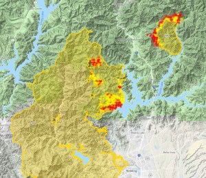
The pair of isolated heat blooms on the northeast corner are probably backfires being conducted on Middle Ridge, where a fire line is being cut in. Hopefully that project continues swiftly and the line is able to be built all the way across the ridge and connecting to Red Mountain on the west side. This would contain the fire and also preserve the gorgeous Tamarack Lake Basin (one of my personal favorites).
This map was included in an update yesterday, but I think it is worth posting again. The depiction of the fire is out of date, since it was drawn yesterday but the fire lines have not changed. I drew in the breaks built to contain the Carr and Hirz Fires, as well as the line on Middle Ridge that is under construction. I added a speculative line that I imagine is under construction or would make a good project to contain the fire’s northern advance.
Black = built lines, Dark Blue = under construction, Purple = speculative
I imagine the fire is likely to continue to burn to the northeast, across the Sacramento River. This will consume the Hazel Creek watershed but stay contained by the contingency line built along Sweetbriar Ridge. That, along with the line being built on Middle Ridge (the dark blue line), should protect Sweetbriar, Castella, Dunsmuir and beyond.
With the new day arriving and some clearish skies, I hope the air attack can really continue to hammer at the fire. That, along with the crews cutting in lines, they might be able to put a lid on this thing. Lord willing!
Here is the Delta Fire progression from the last 24 hours:
Sept. 7 9:30 AM
11:00 AM
12:00 PM
4:30 PM
6:00 PM
Sept. 8 6:00 AM
8:00 AM
9:00 AM
Update (10:40 AM):
The fire does not seem to be advancing but things are really heating up. It also looks like more heat blooms on Middle Ridge may indicate backfire operations are expanding. Again, that is complete amateur speculation but it fits with what we know.
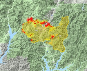
The Delta Fire as of Friday morning. The two large yellow clusters on the right are from the Hirz Fire.
I am going to keep things brief and direct this morning. I will update throughout the day as I see things worth adding.
Read my first two posts on the Delta Fire here and here.
The Delta Fire continues to burn furiously in the mountains north of Lakehead. It has grown to 24,558 acres. Though the fire does not seem to have advanced much to the north, it has expanded on the southwest and northeast corners. The former is not a significant problem, since it is likely to just burn up to contingency fire lines cut in for the Carr Fire. Unfortunately, this is not the case on the northeast side. The fire has gathered strength in the Sacramento River canyon. I hope that they can really jump on this fast. At least with the day arriving they have the opportunity to bring aerial resources into play.
A closer look at the fire. The yellow cluster at center bottom marks the initial expansion of the fire.
Aside from weather conditions, I think there are two challenges (and I am just guessing here. I am no expert) facing firefighters at this time. First is the rugged conditions in the canyon. The sides are steep and tough to access in some places. The canyon also works against aerial resources. It is probably almost like having to make the trench run on the Death Star. The second problem this part of the fire poses is the presence of lots of old clear cuts. These presents the possibility of accelerated spreading of spot fires.
This perspective is looking from east to west. It gives a little more sense of the ruggedness of the terrain.
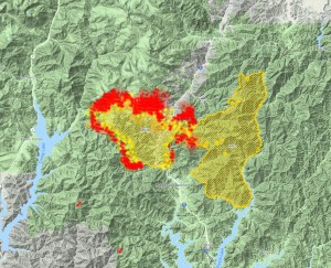
On the east side of the fire, the Delta Fire has linked up with the older Hirz Fire. This does function as something of a natural fire break, allowing resources to be more focused on areas of more pressing need. There are some blessings to be found here. First, the fires are now connected in more ways than one. The command and resource structure of the Hirz Fire has taken over the Delta Fire. Among other things, this means that a lot of assets and firefighters are able to be allocated swiftly. If the fire keeps burning to the southwest, it may eventually close the gap with the Carr Fire. If this happens, there will be, amazingly, one long black scar running across the southeast corner of the Klamath Mountains. In a roughly 45 mile arc, it will stretch all the way from Igo to just southeast of Dunsmuir. That is absolutely shocking.
This map is a bit out of date already, the Delta and Hirz having merged.
While the canyon is under dire threat, the fire has not advanced to the north much. While human geography is more important than the natural, I have been hoping that the Tamarack Lake area might be spared. While this is by no means a sure likely outcome, it has, thus far, dodged the bullet. I am hoping it continues to do so.
Here is the progression of the fire throughout yesterday to this morning. Note how the intensity subsided a bit yesterday, flared up in the evening and then expanded into the canyon north of Pollard Flat. That is the really critical point of defense right now.
Sept. 6 1:00 PM
2:00 PM
4:00 PM
5:00 PM
6:30 PM
10:30 PM
Sept. 7 6:30 AM
9:30 AM
I feel that I need to note that all of the information offered here is my own assessment of the situation and speculation. If anything proves false, I apologize and ask for correction. Let’s hope this thing gets whipped soon!
Update (1:00 PM):
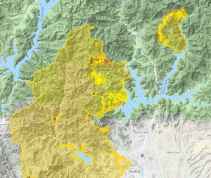
Black = built lines, Dark Blue = under construction, Purple = speculative
Based on the current Delta Fire activity report and the already extant fire lines cut in to defend against the Carr and Hirz Fires, I think it is possible to start to get an idea on what the plan is for the Delta Fire. On the map above, I marked all the Carr and Hirz fire lines in black. Some of those are already in use, holding back the Delta Fire. The activity report states that bulldozers are currently cutting in a line on Middle Ridge, which runs from roughly Sims up to Baker Point, above Tamarack Lake. This is marked on the map in dark blue. I am guessing, though I have no confirmation, that they will try to hold the ridge running from Baker west toward Red Mountain and then down to the East Fork of the Trinity River. I marked this speculative line in purple. This seems like the most effective and logical place to make a stand on the northwest side of the fire. I sure hope so, otherwise a lot of place we all love to visit are exposed to the flames.
The Delta Fire started off with a bang yesterday. It quickly expanded from a few acres to 2,000 acres to 5,000 acres and then, during the night, exceeded 15,000 acres. As of the time of this writing, (about 9:00 AM) I would bet it is approaching 20,000+ acres. Unfortunately it is officially at 0% containment. The weather is going to be warm today with dangerous conditions returning again in the afternoon. I am praying for the firefighters and that they can put a lid on this thing really quick.
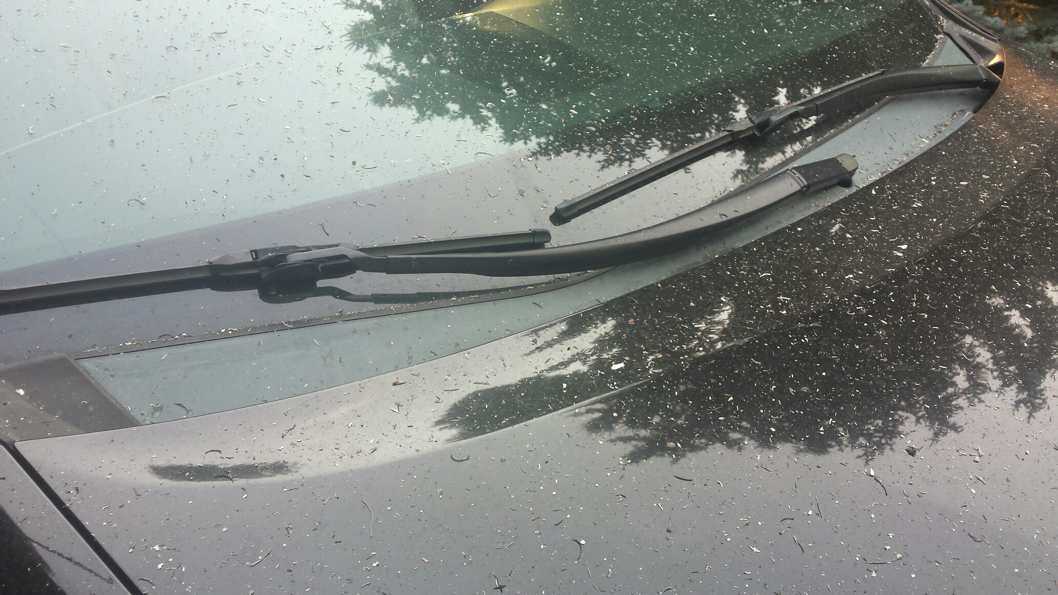
Here in Mount Shasta, the conditions are smoky and ash continues to fall out of the sky. I was up last night around 3:00 AM and the ash was reminiscent of snow. Would that it were. When it was light out I checked the conditions outside again and there was ash everywhere. Some schools have been canceled for the day, though I imagine that this move was done largely to keep people off the freeway and roads. Evacuations are in effect as well, stretching from Lakehead all the way to the Shasta County line. South Dunsmuir has also been evacuated, but I am guessing that this is referring to the area that lies immediately on the county line, near Railroad Park. This includes Castella, Sweetbriar and the Soda Creek area.
The fire now is officially listed as 15,294 acres but that is no doubt an out of date estimate. The fire is burning on both sides of I-5 and it is likely that, despite the sparse settlement in the area, there are some destroyed structures. On the east side of the freeway, the flames jumped the Sacramento River and are now actively burning toward the Hirz Fire. The real problem area is on the west side of the freeway, where the flames are massive and are consuming the Slate Creek watershed. Check the maps below:
The last image, being the most recent, is obviously the most pertinent and shows just how intense the fire is. Unfortunately the flames are encroaching toward the Tamarack Lake Basin, one of my favorite spots in the Trinity Divide. I really hope that area manages to escape the flames. It may be that this fire erases the last bits of the Trinity Summit Trail too. Sad.
I do think there is a little good news in all of this. Ironically, the fire is burning right in between the north end of the Carr Fire and the Hirz Fire. This means a couple of things. First the previous fires have significantly reduced the fuels in those areas, making them somewhat natural fire breaks. Second, there were contingency bulldozer-cut fire breaks that were cut in to contain those fires if the lines that ultimately stopped the flames failed. This is particularly useful on the southwest side of the Delta Fire. On the map, those lines are what have prevented the fire from advancing on Lakehead.
Map made by Deer Creek Resources. The white lines indicate contingency fire lines already in place.
Another good bit of news (this is unconfirmed by a second source) is the small heat blooms visible next to Trinity Lake. These have been reported to be backfires already begun to block the the westward advance of the fire. North of this back fire area is Bonanza King. This is the largest mountain between the Trinity Divide and the Trinity Alps. At 7,000 feet and very rocky, it may serve as a natural fire break on the west.
The north end of the Slate Creek watershed is made up of Middle Ridge, which also hems in the Tamarack Lake Basin. This would be a good place to stop the fire’s northward advance, if they are able to hold that area. The other really troubling spot is the west side of the Sacramento River Canyon. It has a lot of clear cuts and those are easy places for spot fires to start.
Today is critical in containing this fire and I believe that significant resources have been diverted to fight the fire. Hopefully that is the case. I’ll be saying prayers all day. I hope everyone else is too.
Update (10:00 AM):
An official map as of this morning has been put out. The fire has already expanded beyond its lines depicted here but this does help show where the fire is at:
One good bit of news that the map indicates is that the small village of Delta may have survived. Most folks probably don’t even know it is there but there are a number of old houses right on the Sacramento River. I had figured the town got obliterated but, at least according to this map, Delta may have survived:
Also, I have heard that the gas station at Pollard Flat survived. Let’s hope that is the case!
Update (10:45):
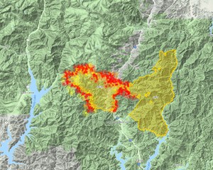
The Delta Fire at 10:45 AM.
The scanners indicate significant air resources are being diverted to the Delta Fire. This certainly is a good thing. If the contingency lines left over from the Carr Fire hold and and the fire around North Salt Creek can be channeled into the Hirz Fire, then the northern area is the most pressing area of need. Perhaps much of the air resources will be used to bottle the fire up, especially along Middle Ridge. That is the most obvious natural line of defense and I hope they hare able to make a stand there.
Update (2:00 PM)
The smoke has really shifted to the west since this morning. The Trinity Divide is really socked in but Mount Shasta is relatively smoke free. It sort of feels like rain but none is in the forecast. It all feels very strange.
Smoke has inundated Mount Eddy and the Trinity Divide.
Mount Shasta is surprisingly smoke free.
The heat blooms on this map make it look like the fire is losing its intensity. I am sure that this is not the case, but it does give some cause to hope that perhaps they can close the door on this really fast. I suspect that there will be an update soon indicating the fire’s actual, and likely substantial, activity.
Also, if you are trying to get around the fire watch out for big rigs on both Highway 3 and on Highway 299. Hwy 3 was blocked by a big rig last night and 299 is currently blocked by an accident involving a big rig.
Well….you can sort of see the summit of Mount Eddy through the smoke.
It has almost seemed like a wasted month here in Mount Shasta. The Carr Fire has continued to burn, the Hirz Fire has sprung up right next door to it and grown to over 12,000 acres. Worst of all, the smoke has been think, nasty and nearly ubiquitous. However, the last week has seen a slight weakening of this pattern. There have been short stints of clarity as the winds shifted and drove the smoke out of the valley, if only briefly. Thursday was the brightest spot, as the air quality improved to the point that Mount Shasta was a clearly visible as it normally should be. This seemed like the first time that had happened in a month. However, even that bright moment was fleeting and the pall of smoke encroached once again, shrouding everything around us so that, even from the Abrams Lake overpass, Black Butte could not be seen. Disgusting.
The Pacific Crest Trail Association has a useful tool that puts up a satellite image of the entire PCT each day. This is a great tool for comparing the conditions. Here are the images for August 17th and 18th:
August 17: The smoke covers the Strawberry Valley. Note that the Trinity Alps are clear.
August 18: More smoke covers the entire region. The Strawberry Valley is really socked in.
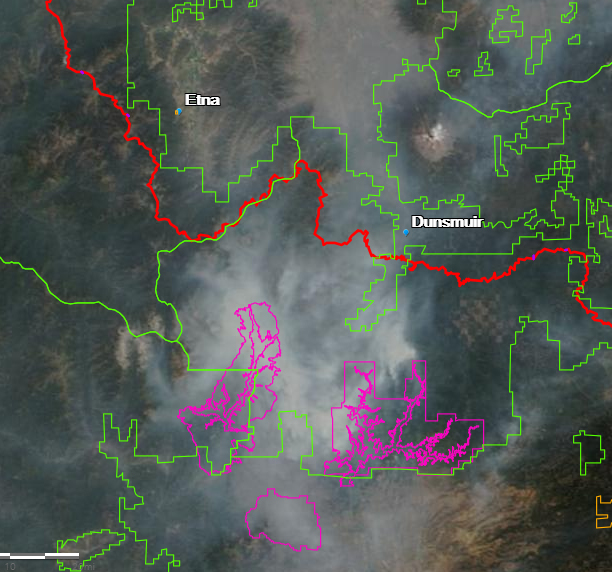
However, I believe that we are nearing the end of this ordeal. I have continued to follow the progress of the Carr Fire via CalTopo and it has been remarkable watching the fire burn itself out. The most optimistic event in this has been the seeming total success of the fire line that was cut in north of the Carr Fire over a week ago. This line started at Shasta Lake near Lakehead and climbed up Backbone Ridge all the way to Damnation Pass. From there is swept west past the very remote Clear Creek campground and then south along the crest of the Trinity Mountains. Here is how the fire looked little over a week ago:
The firebreak is the thin crescent of fire extending from the top of the Carr Fire all the way to Shasta Lake.
If my calculations are close to correct, that fire break is about 18 miles long. It basically bottles the fire up inside the Clear Creek watershed and forcing the fire down to the edge of Shasta Lake. If the fire break held, the plan was for the fire to consumer everything from the crest of the Trinity Mountains down to the lake, at which point it would essentially burn itself out. As planned, this is exactly what happened. Note the progression of the fire on this series of maps:
August 12
August 17 10PM
August 18 8:30 AM
August 18 3:30 PM
August 18 6PM
August 19 7AM
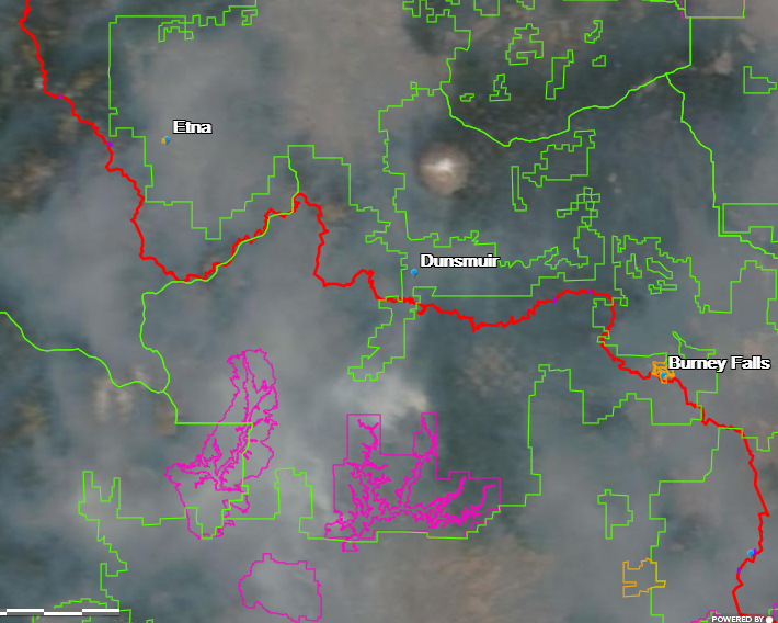
It is obvious from this progression that the fire is essentially burning itself out. It has consumed everything all the way down to the shore of Shasta Lake. There is nowhere left for the fire to go and there is nothing left to burn. Now it is just a smoldering mess and we can just wait for the smoke to eventually blow away. Of course, what this map also reveals is the growth of the nearby Hirz Fire. It is now putting out a significant amount of smoke of its own so we still have that to contend with. However, I hope that the knowledge that we are near the end of the Carr Fire is encouraging.
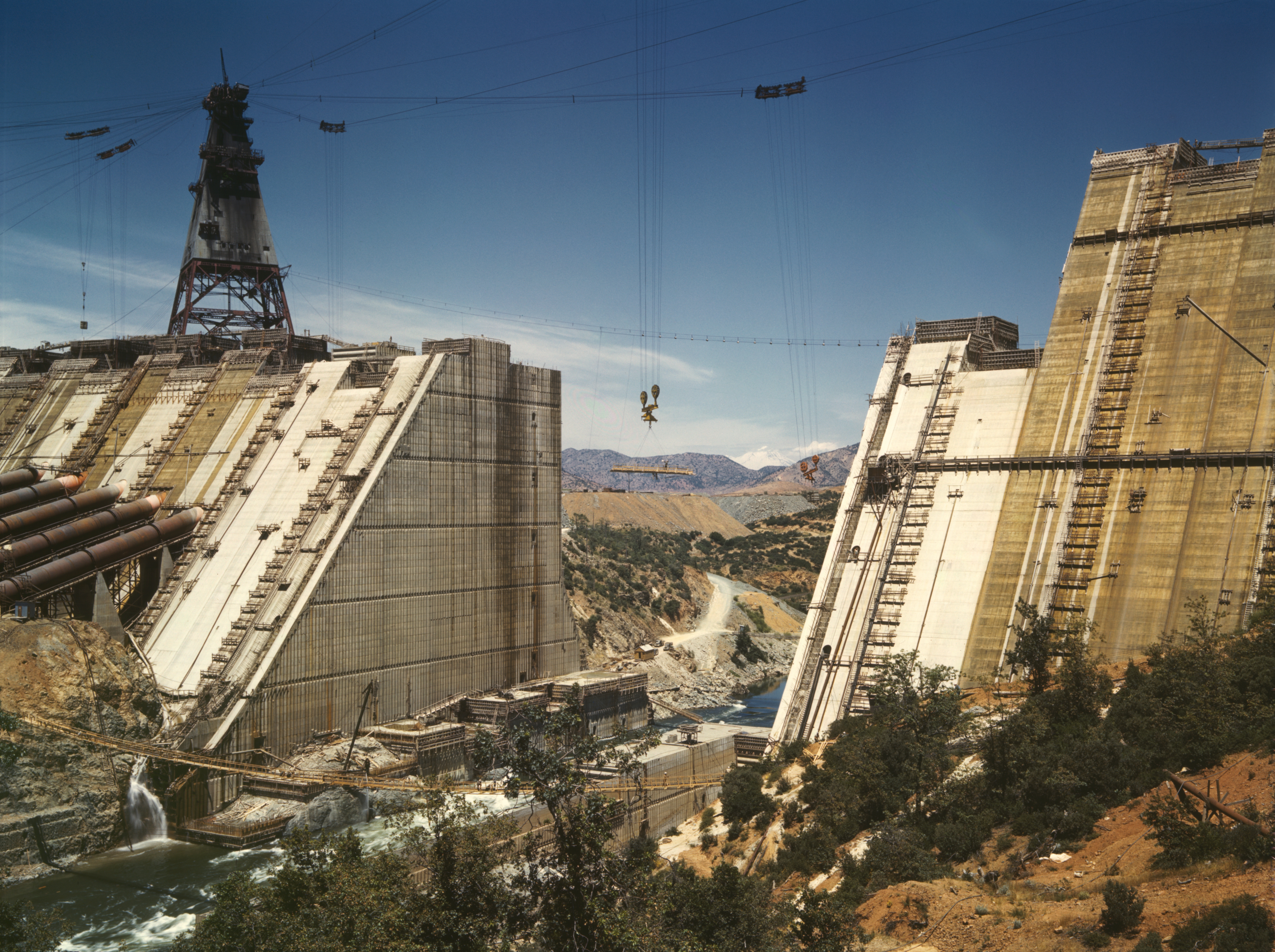
All we are left with then is the charred mountains that hem in the northwest corner of the great Central Valley. In some ways, it brings that area full circle. Much of those hills had been rendered bare by mining operations and other activities at the turn of the century. When the Shasta Dam was built, there was little vegetation on the surrounding mountains. We have returned to similar circumstances and get to watch nature heal all over again. Hopefully the air will be the first thing to clean up and soon.
Note the bare mountains in the distance through the gap in the dam. They are bare once again.
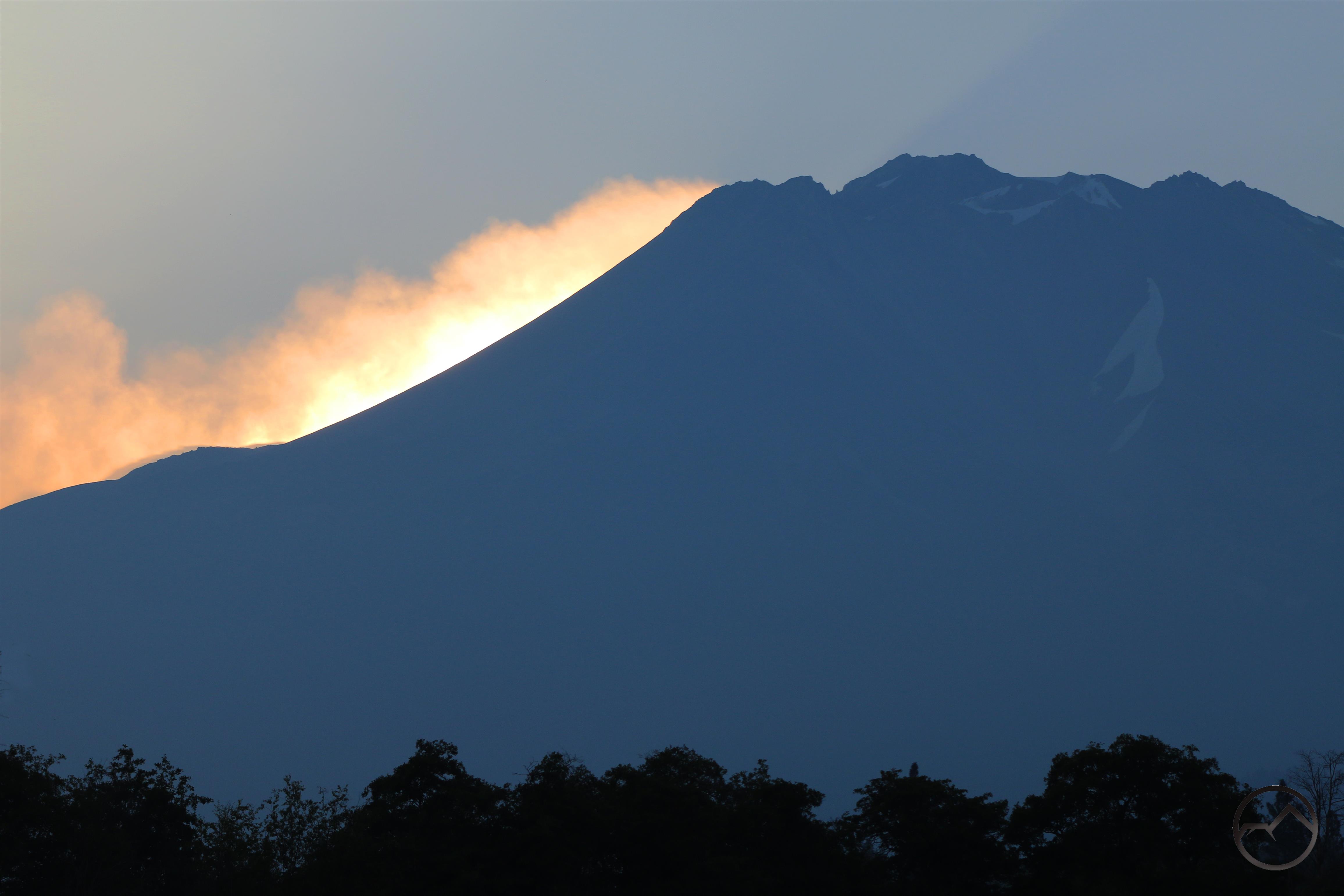
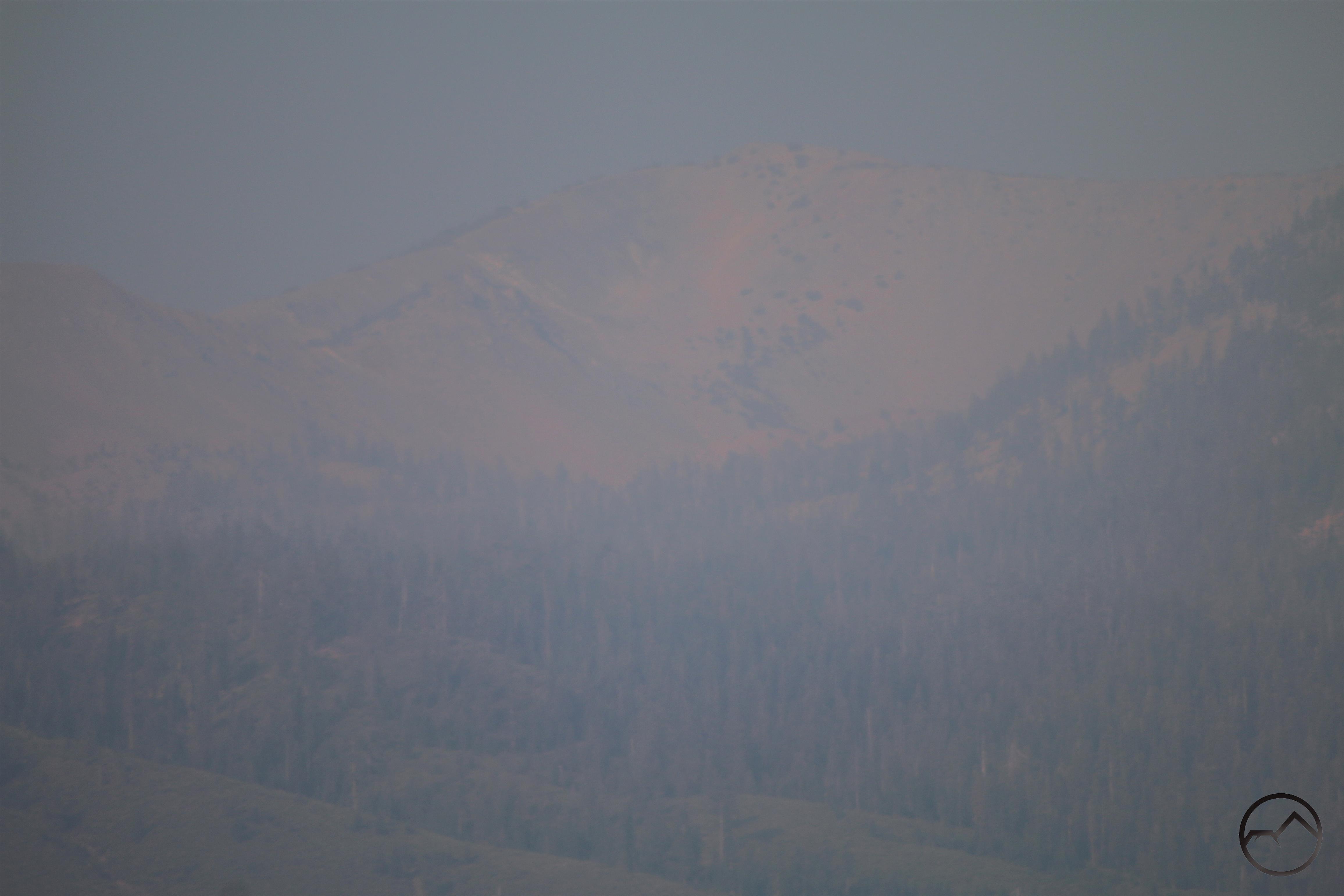
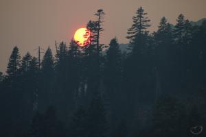
Meager alpenglow illuminates the thick blanket of smoke on Mount Shasta.
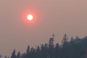
The last couple of days had somewhat better air quality in Mount Shasta despite the still-burning Carr Fire as well as the addition of the newly ignited Hirz Fire. Nonetheless, the smoke poured back into the area around the mountain with a vengeance today. In spite of this, my family and I went up to the Old Ski Bowl to have a picnic dinner. No doubt due to the smoke, the entire mountain from Bunny Flat to the end of the road was strangely empty of activity. It made our dinner strangely eerie. While my kids played on the rocks, my wife and I watched the sun set amidst the smoke. Oddly enough, we spotted someone descending past the sun on a parachute. After this, I managed to capture a few images of the smoky but gorgeous sunset. At least some beauty can be found midst the terrible conditions.
Click to enlarge:
Note the parachute!
Everyone is eager for the smoke to clear out. Hopefully the end is in sight. A quick glance at the Carr Fire incident map from 10 August reveals a well-established fire line hemming in the conflagration’s northern advance.
The long line at the top of the map indicates the fire line that has been established. I imagine that the plan is to let the fire burn up the Clear Creek watershed and then get contained within the lines. Everything below the line will like get consumed by the flames but the fire will have been effectively bottled up. The live map, as of 12:30 AM indicates that this is the case:
Note how the valley below the fire break is filling up but, for the most part, the fire has not advanced past this rallying point. Hopefully the fire line will hold and this will spell the ultimate end of the Carr Fire. Unfortunately, as is evident from the map, the new Hirz Fire has sprung up along the McCloud arm of Shasta Lake. Let’s pray this fire is brought to heel swiftly. Either way, it feels like, at long last, we are nearing the end of this ordeal. Lord willing.
For my birthday, my wonderful wife sent me off to Texas for a few days to hang out with my best friend for a few days. He has been my best friend for 16 years but, since we finished school in 2006 and I came back to California from Texas, I have only seen him 6 times. We talk all the time, but distance keeps us from spending time with each other. Not only did she send me out there, she bought tickets to one of my favorite Texas country stars. Needless to say, my friend and I were both excited for a weekend of no work, no kids, lots of barbecue and music and time hanging out together.
The one drawback was I had to fly out to Dallas first and I am not a fan of flying. The way I have coped with this is by sitting by the window and trying to figure out where we are by the landmarks visible below. This trip was no different, though the smoke and a bunch of storm clouds did obscure the view of a good portion of the trip. However, what I did see, especially in our local area, was quite interesting. Hopefully it is interesting enough to endure a few pictures of Texas too…
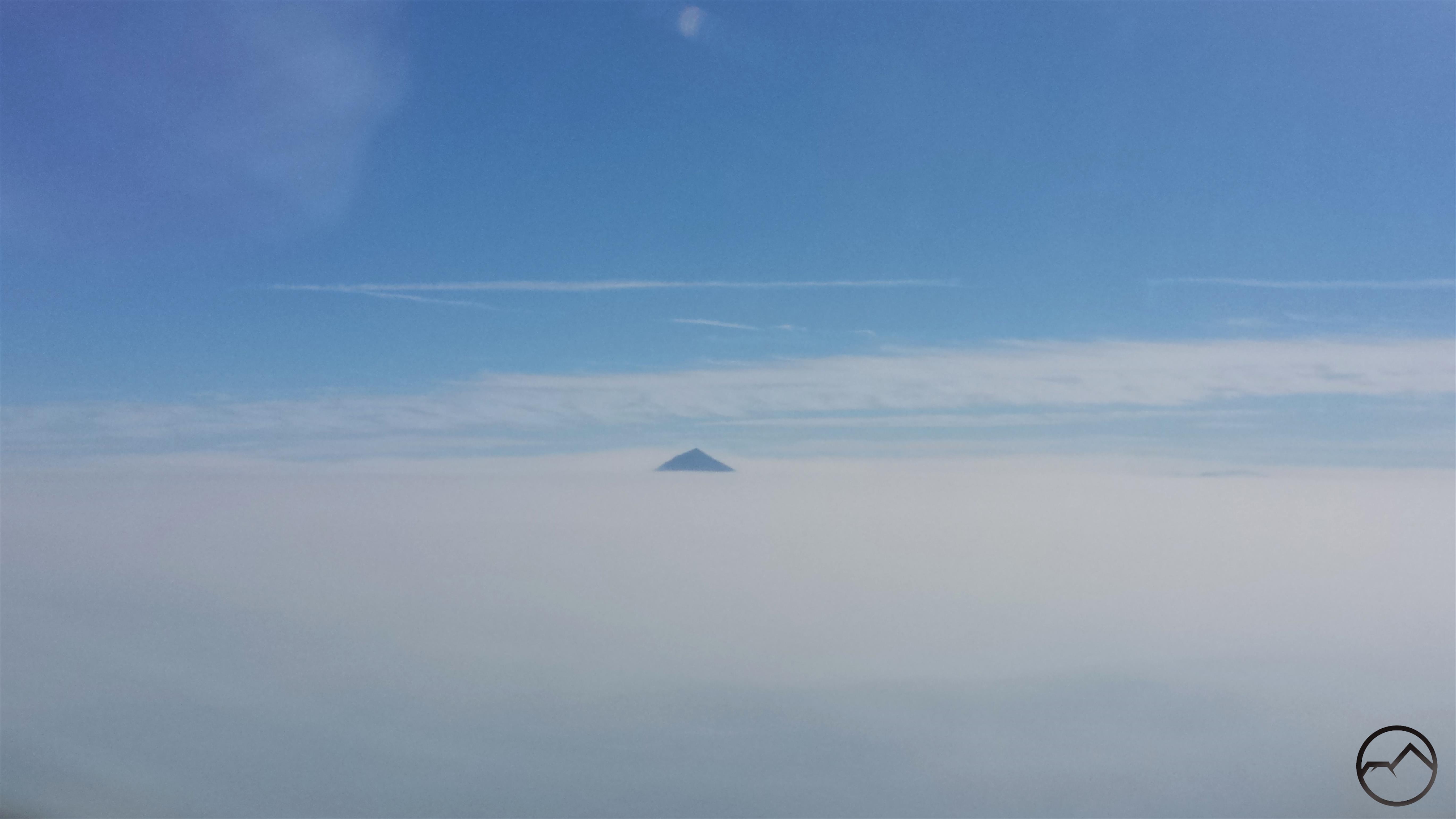
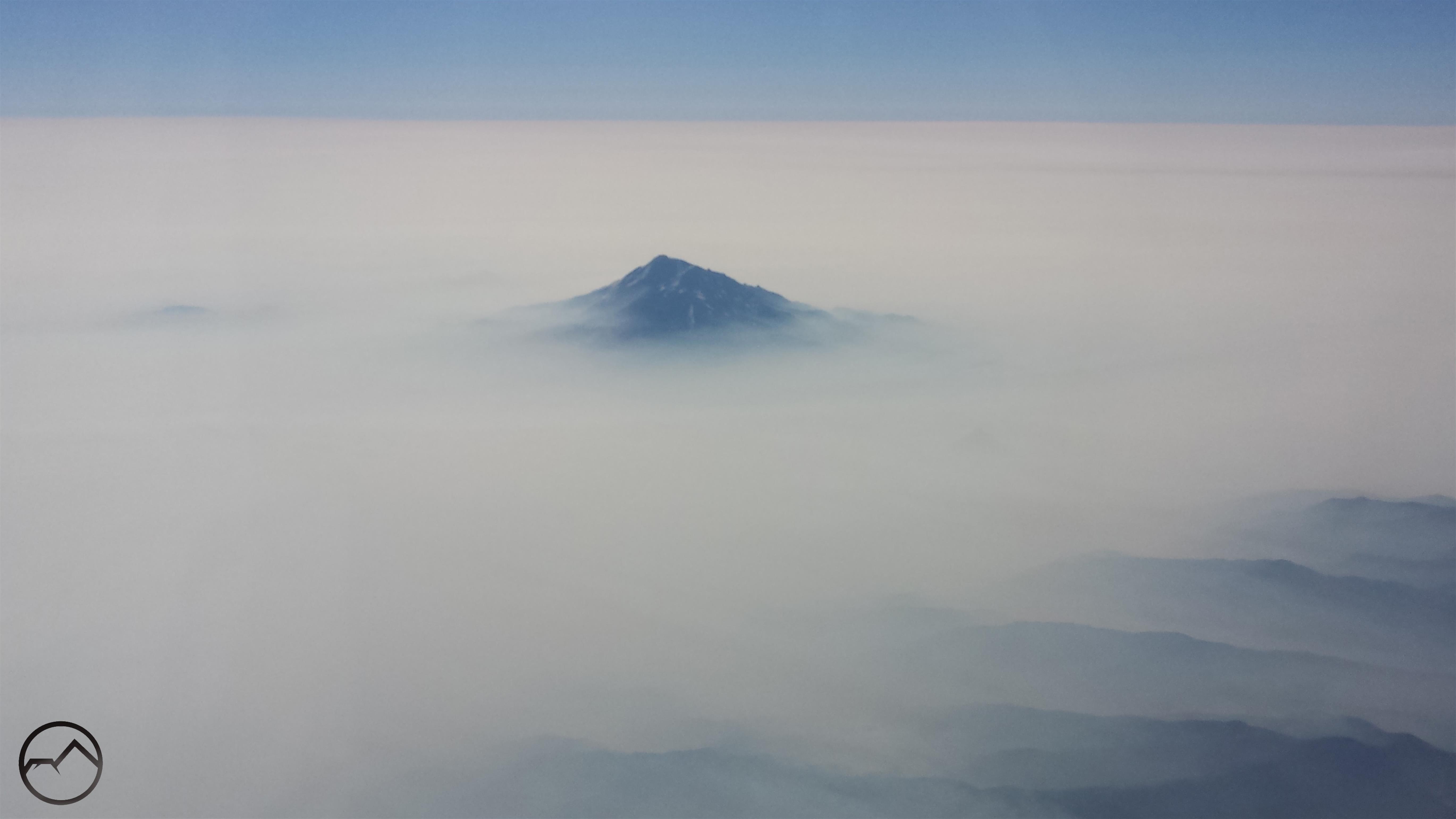
I flew out of Medford, which was even smokier than it was here in Mount Shasta. However, shortly after takeoff I spotted Mount McLoughlin poking up from the top of the smoke. At 9,493 feet, it was a good barometer for how high the smoke layer extended.
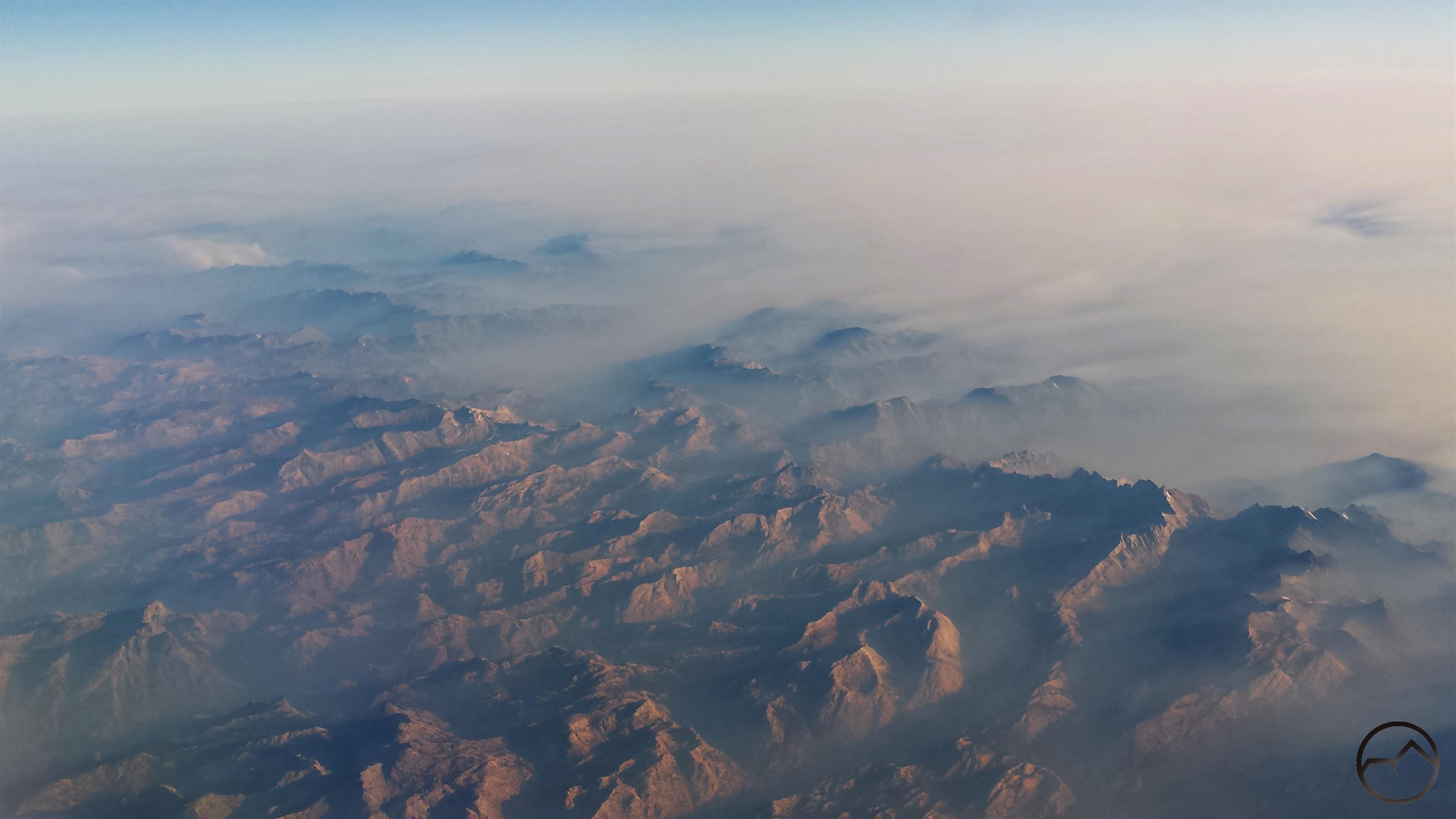
After flying over the Marble Mountains and Russian Wilderness, I finally had a good perspective on Mount Shasta. Several thousand feet of the mountain rose high above the smoke. It seemed like an island of clarity amidst a sea of chaos. Several other landmarks were visible, including the Whaleback, China Mountain, Mount Eddy and Porcupine Peak. The visibility, such as it was, of much of the Trinity Divide was evidence that the smoke was actually a bit better than it was in southern Oregon. It was good to see the mountain after its obscurity in the smoke for several days.
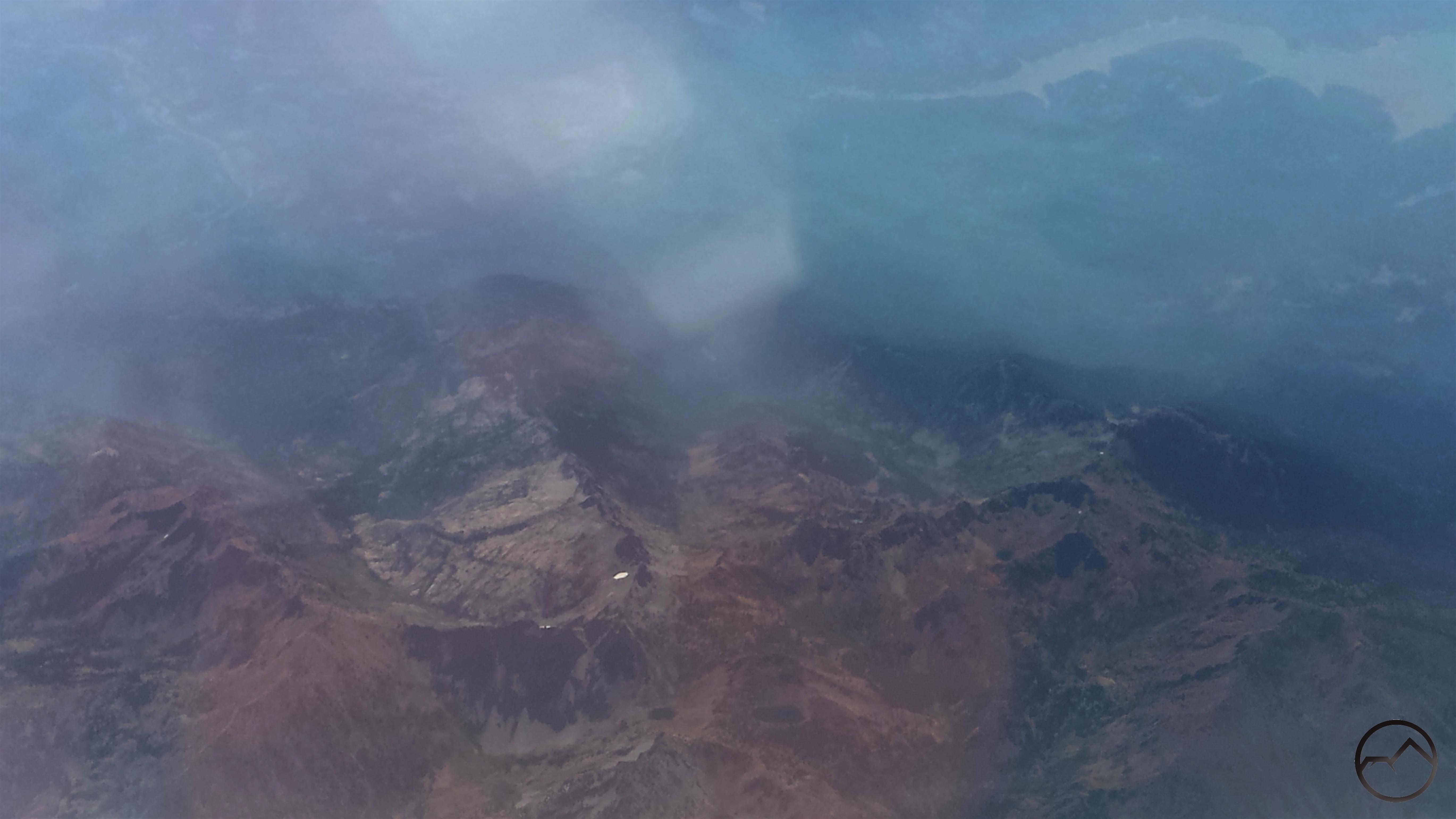
Next up was the Trinity Alps. These were surprisingly smoke free, which is remarkable considering how close they are to the Carr Fire. The area visible in this image includes Granite Lake and Gibson Peak near center and Siligo Peak with Deer and Summit Lakes in the center bottom. Middle Peak and Echo Lake are further to the right. Trinity Lake can be seen in the upper right hand corner.
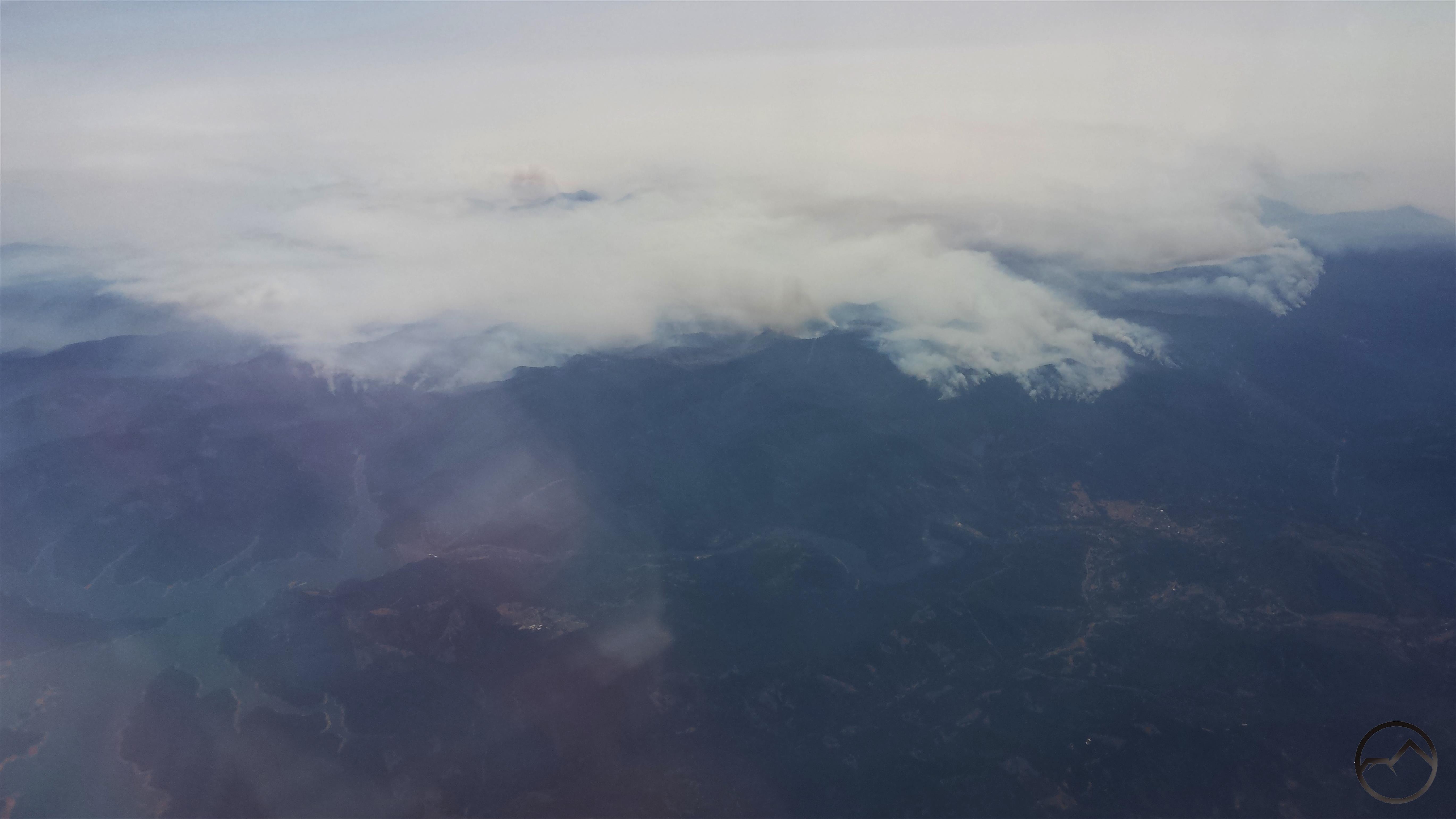
Shortly after the Trinity Alps, the plane flew past the Carr Fire. Here the western edge of the fire can be seen burning down toward Trinity Lake and the town of Lewiston. I could see planes diving low and dropping clouds of red retardant on the fire. It was a pretty dramatic sight.
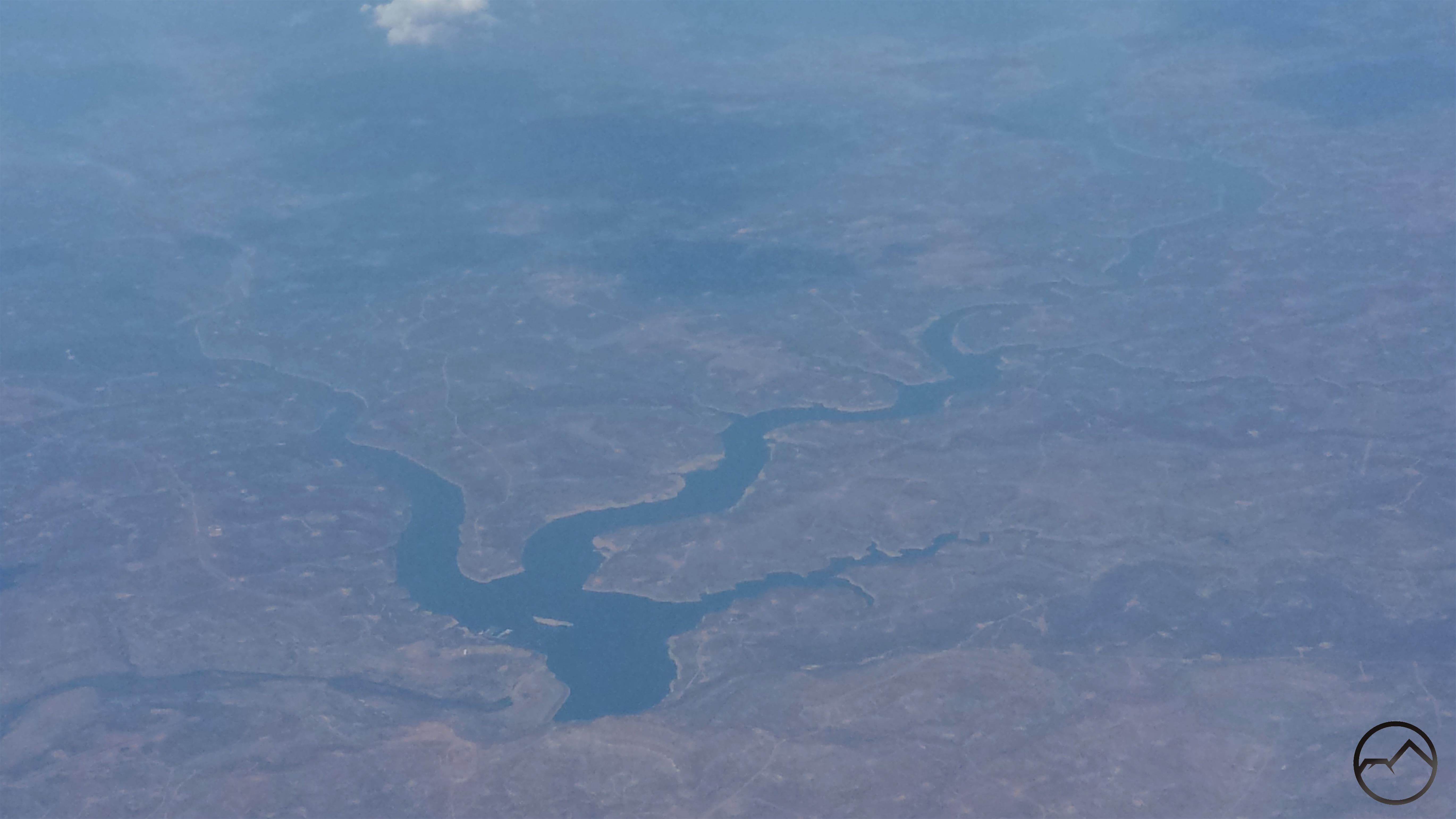
Once we left San Francisco, the smoke and clouds quickly closed in, making for a really bumpy flight. When things cleared up, the first landmark I was able to make out was Navajo Lake, which is near the Four Corner. The lake, formed by impounding the San Juan River, is mostly in New Mexico, though the upper most part of the reservoir extends into southern Oklahoma.
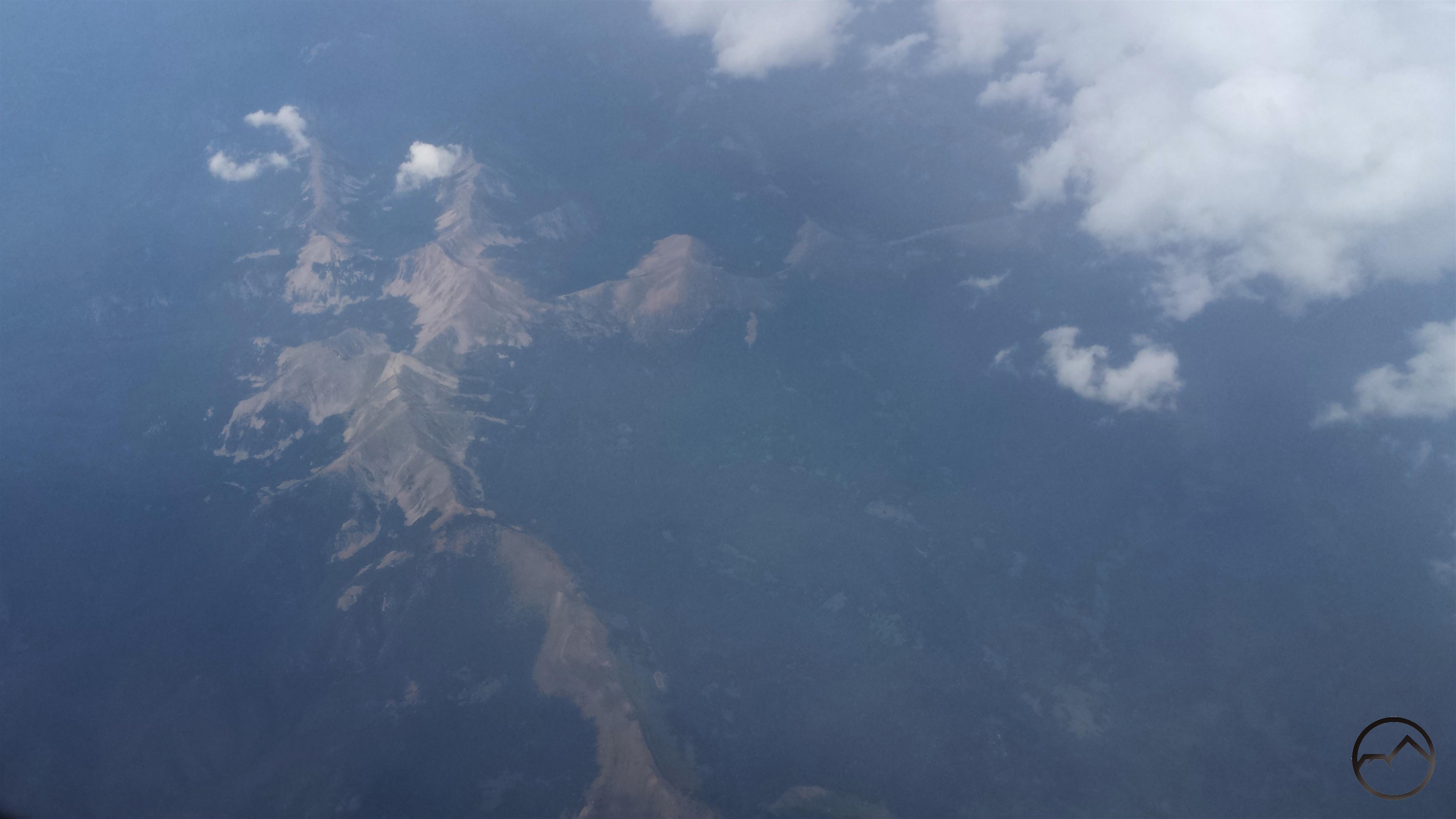
Next up was the Truchas Peaks, the 2nd highest collection of peaks in New Mexico and the southernmost 13,000 foot mountains in the Rockies. These towering summits lie in the heart of the Pecos Wilderness, one of the great wildlands of the Southwest. The darker ridge running vertically at the bottom of the image is the Trailriders Wall. It is probably my favorite spot in New Mexico. If you ever get a chance to explore this area, I strongly encourage it.
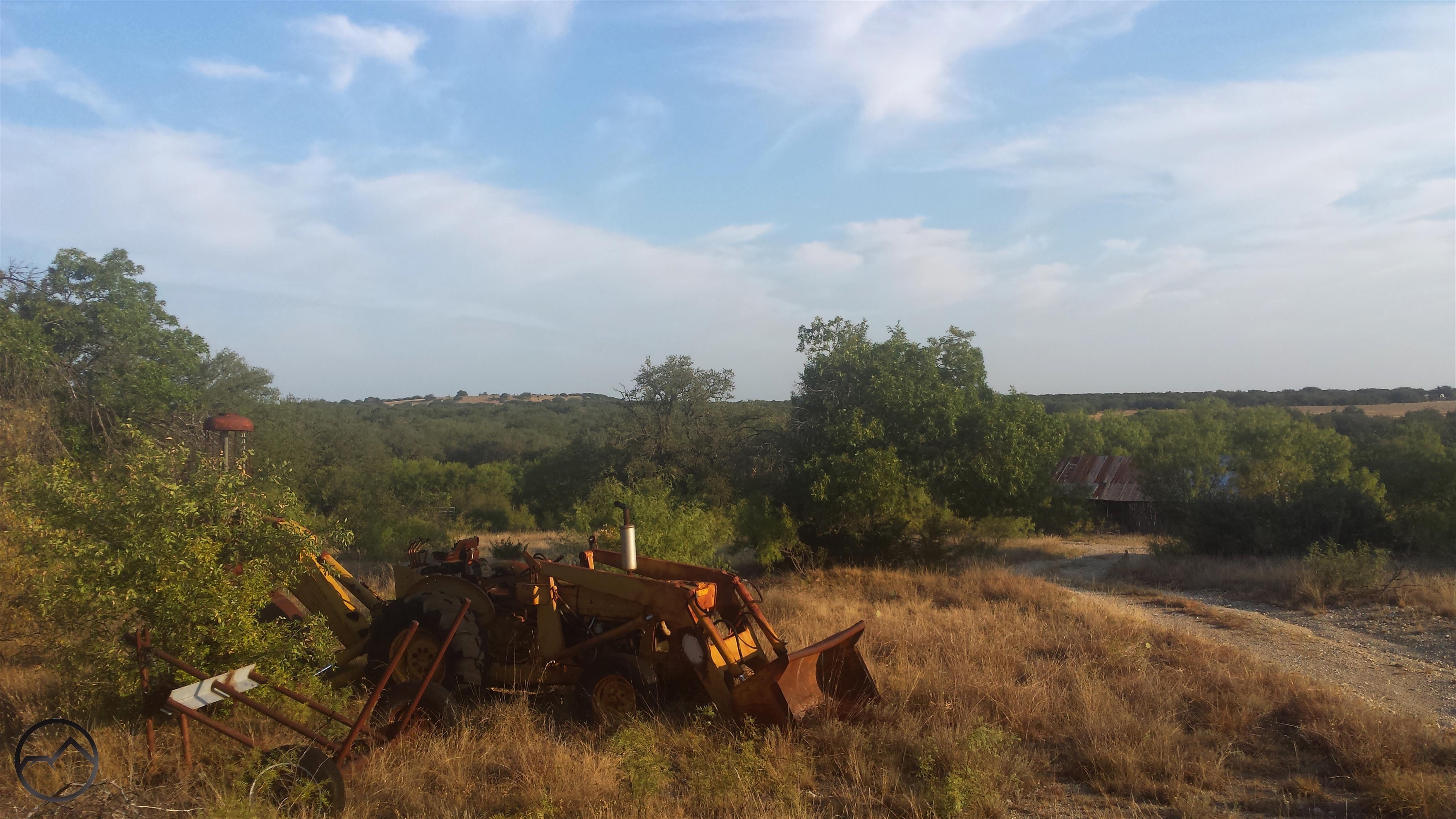
I finally landed in Dallas where my friend picked me up. I hung out that evening and I met his kids for the first time. The next morning we took a lap around our old campus and then headed south into central Texas, to the Hill Country, where he has a ranch. We spent the rest of the day shooting and driving around the old roads that wind around the property, which is several hundred acres in size. I spent a lot of time down there when we were in school together and it was a place with a lot of great memories.
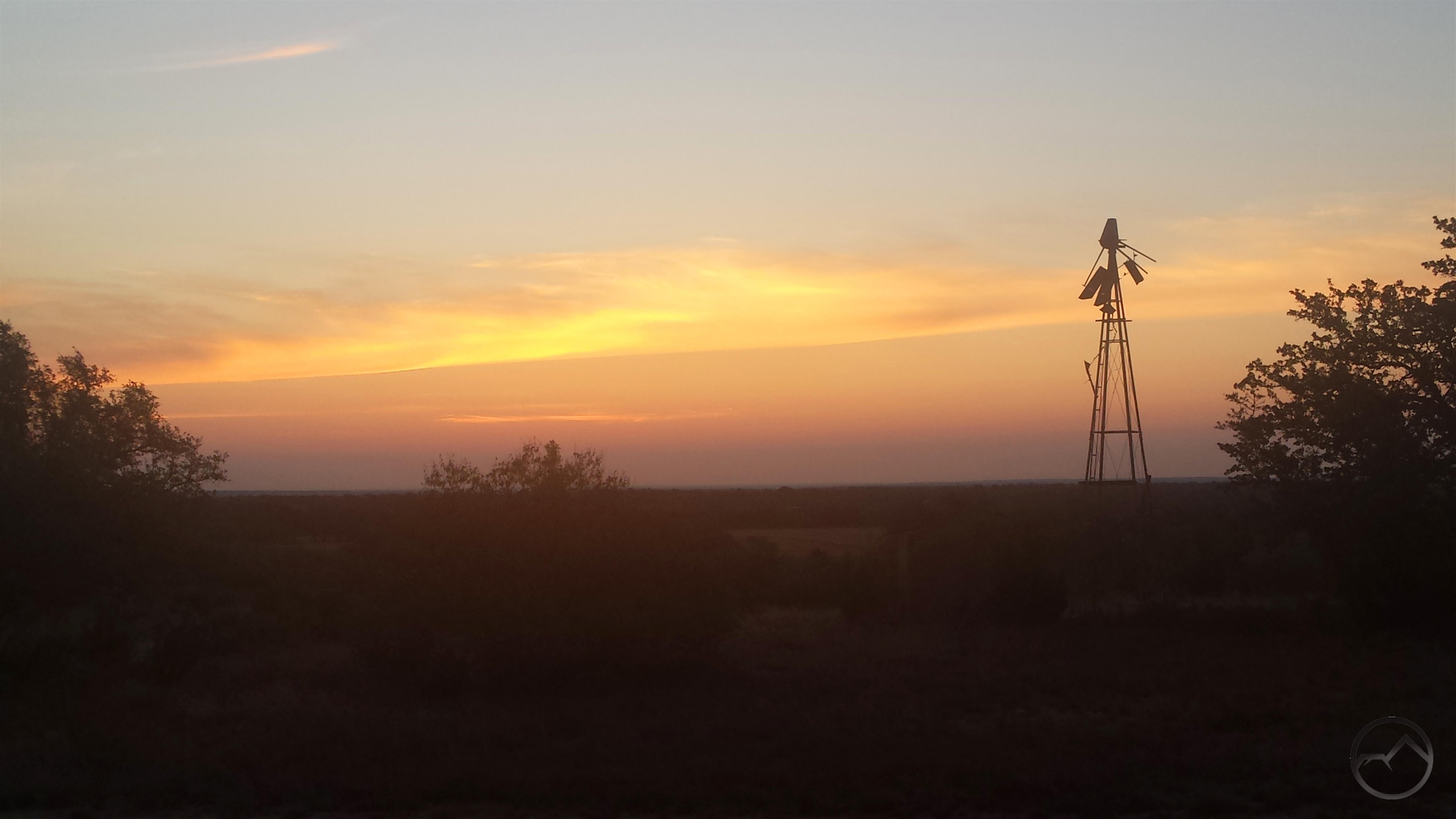
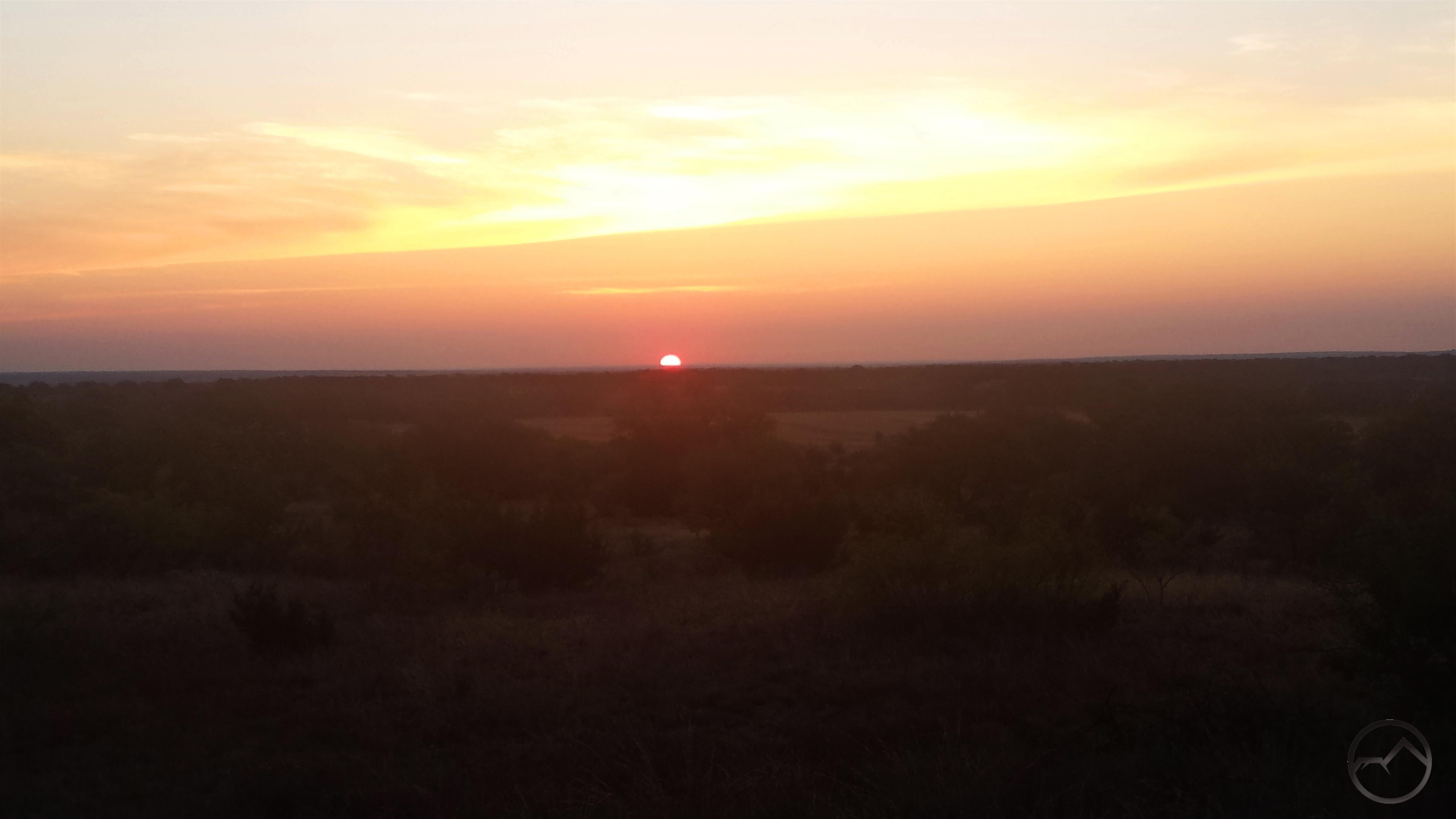
When I first moved to Texas, I had different perceptions of beauty in the natural world. My time there broadened my sense of what what beauty was, where to find it, and how to appreciate it. Naturally I prefer mountains and other such environments but it was good to get back into a land more subtle and be reminded of the value of the great scenic palette we have in this country. The sunrise we watched from the bluff was particularly magnificent.
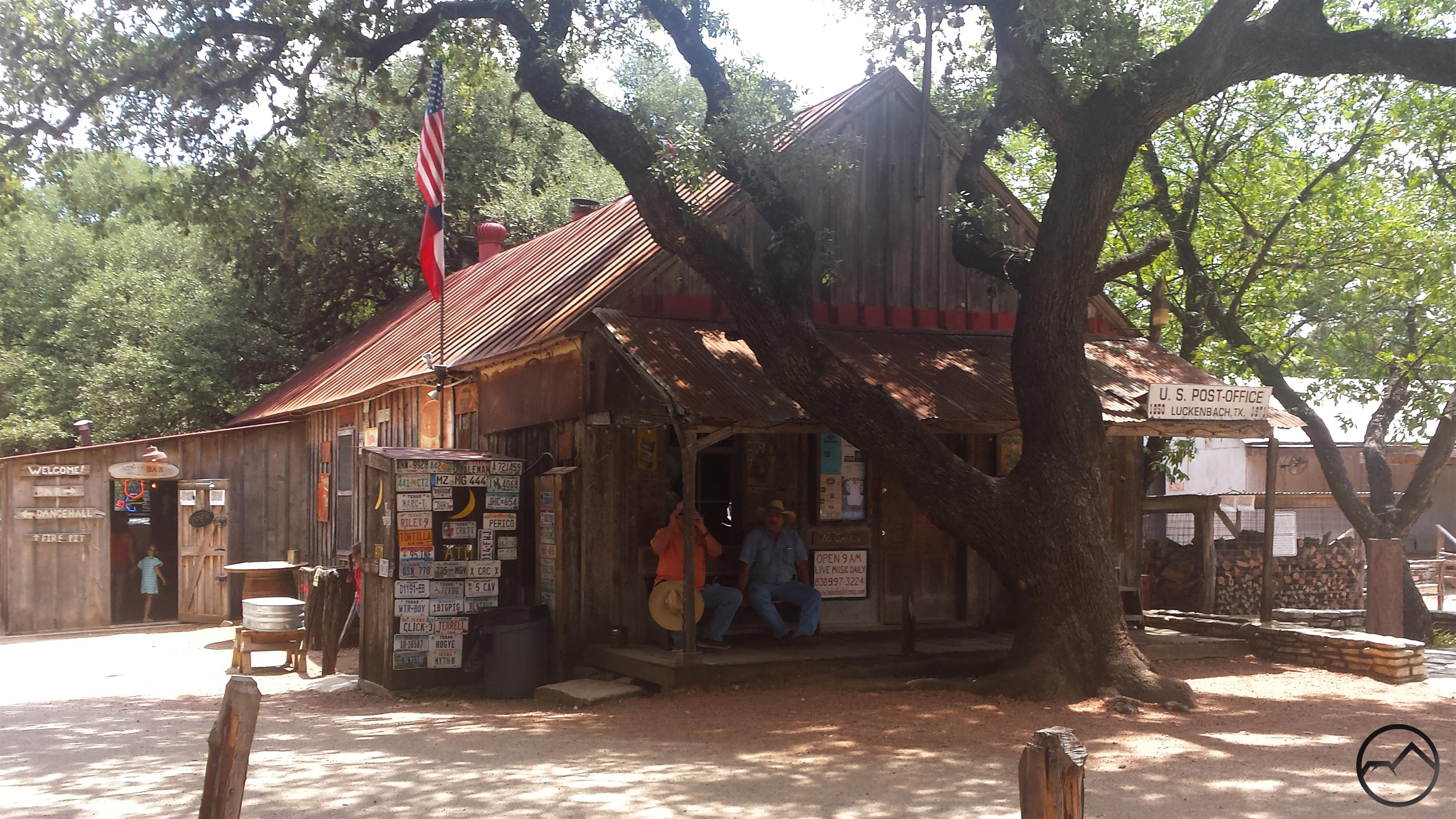
After leaving the ranch, we headed to Lockhart, Texas, where we planned to feast on BBQ for lunch. On the way, we went through Luckenbach, which is, though a bit of a tourist trap now, still sort of the center of the Texas country music scene (Gruene Hall is the real heart of Texas country, of course). Once in Lockhart we had lunch at all three of the great barbecue places, Blacks, Kreuz Market and Smitty’s. All were amazing but Kreuz was far and away the best. If anyone is in that area and likes BBQ, stopping and having some brisket is a moral imperative.
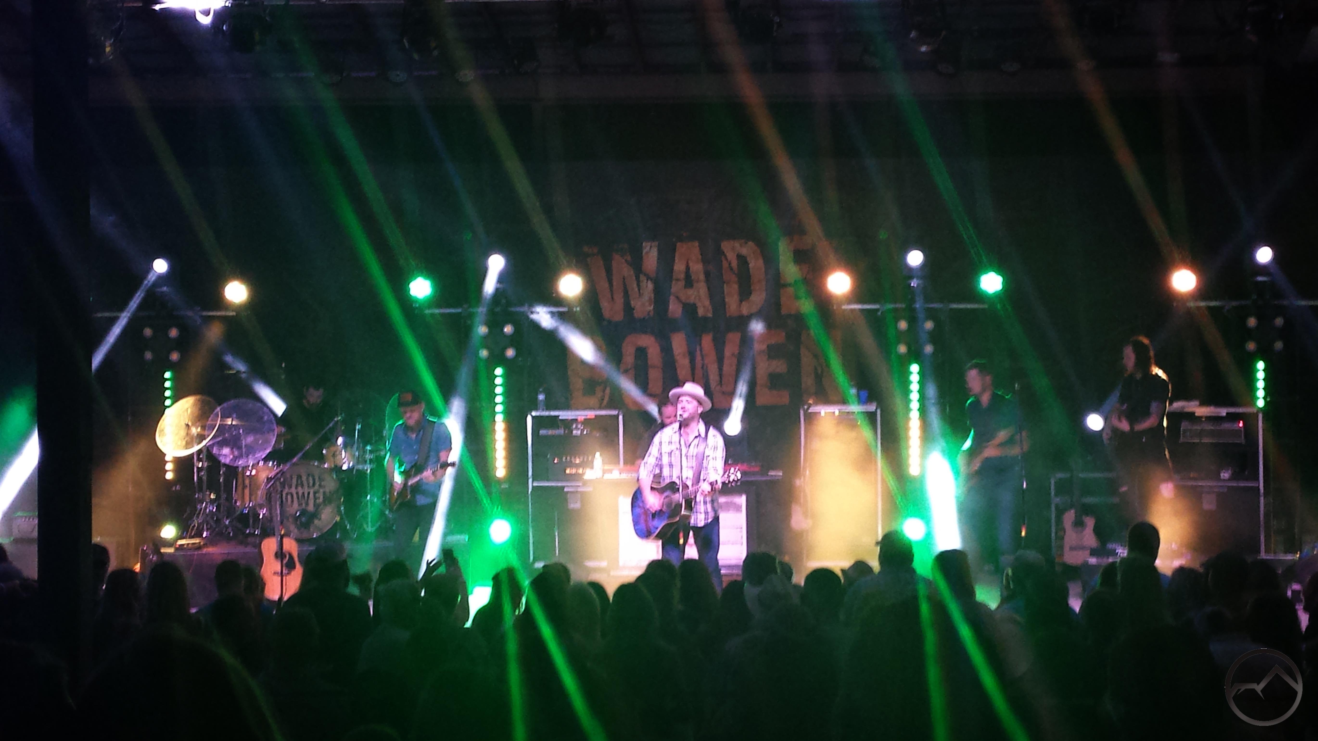
That night, we went to New Braunfels and watched Wade Bowen. It was a fantastic show. In my assessment, he is the top of the heap in the current Texas music scene. A few samples, if anyone is interested, can be found here, here and here. After that, it was one more day to hang out with my friend, head back up to Dallas and get ready to leave the next morning. It was a quick but great trip.
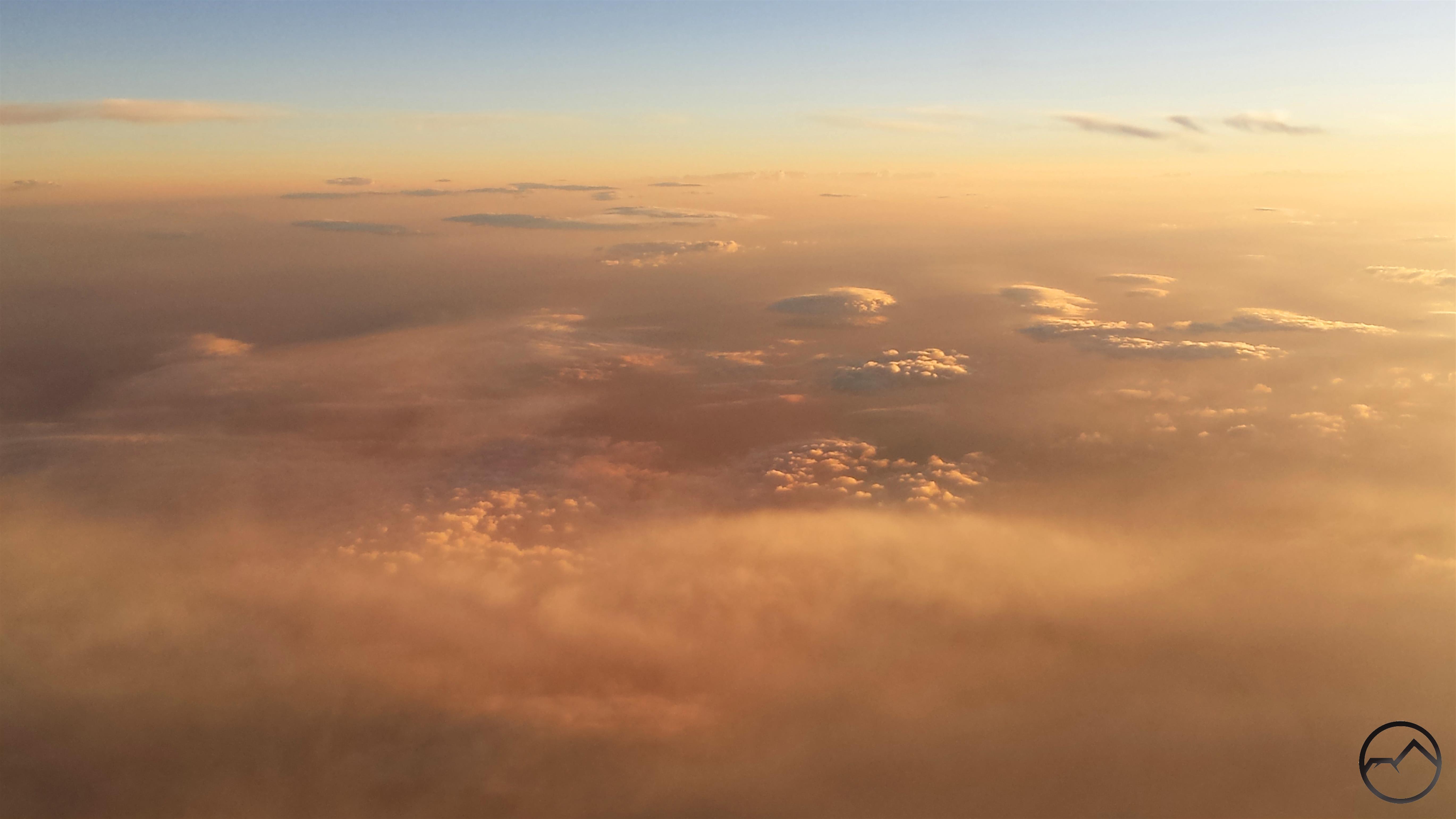
My predawn flight let me watch the sunrise from the air. It was magnificent. However, smoke covered much of the Southwest. It began halfway between Dallas and the New Mexico border an continued, for varying degrees, all the way to San Francisco Bay, where it came to an abrupt halt on the eastern edge of the Bay. San Francisco was crystal clear.
Near the end of the flight, we made a dramatic crossing of the Sierra Nevada. The bulk of the smoke covering the Great Basin was held back by the mighty mountain range. The morning light, mixed with the thin smoke over the Sierra turned the range pink. Range of Light indeed. Special credit to anyone who recognizes where this is. There are a number of good clues if anyone is a real geography nut and wants to figure it out.
The smoke was really thick all over California, but once again, Mount Shasta rises above it. I sure will be glad when this all blows away. Though it is small consolation, this stuff is everywhere, from Texas to California, so it is not like we are particularly afflicted.
I just want to offer a special thanks to my amazing wife for such a fantastic and selfless birthday gift. I am blessed beyond words.
DISCLAIMER: Any use of the information contained in this site by any and all persons is done at their own risk. The operator of this site shall be held harmless from any and all alleged claims, demands, causes of action, liability, loss, damage and/or injury to property or persons whether brought by an individual or other entity. This indemnification applies, without limitation, to all actions by an individual or other entity as a result of their use of information contained in this site.